We are taking a long day’s drive through the East Coast, covering 665 miles over 5 states and a district. Despite being solidly along the coast, the route will be fairly forgiving, cutting through Raleigh, Richmond, DC and then… Harrisburg? There is enough urban driving, and then the drive into the Poconos to account for, so our speed will only be about 62.5mph on average. Still, 5 states in a day? Not bad.
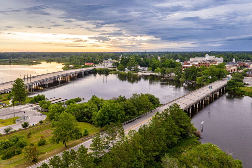
Jacksonville, North Carolina
It’s just that time of year. A low in the Gulf Stream is tailing a boundary into the Carolinas. It’s enough that there is widespread shower activity in the Appalachians tonight, and it’s liable to be a foggy morning as far north as DC. There will likely be showers embedded within the low clouds throughout Virginia as we make our way northward as well. I’ve been in Virginia only a couple of times, and it has rained every time. Is that a thing? Crossing the Potomac, and then heading north into Pennsylvania will be a bit nicer of a time. We will arrive in the Finger Lakes with mostly cloudy skies and a muggy atmosphere. The next boundary will be sliding out of Canada, making sure we don’t have TOO much fun in Ithaca.
We put together a forecast for Jacksonville early in May, and a couple of sources, including Victoria-Weather, thought the shower and storm activity in the area might indicate that there would be a recurrence the next day. This didn’t happen. Ultimately, that wasn’t the thing that turned the tide for anyone, but I think most in Duval County were happy for a rain free couple of days before it gets too hot. The Weathers Channel and Service drew level with good temperature forecasts, but the consensus was best of all Actuals: May 17th, High 86, Low 75 May 18th, High 84, Low 70
The forecast wheel spun and took us back to the southeast. We are off to Duval County tonight.
At 856PM, ET, Jacksonville was reporting a temperature of 79 degrees and mostly cloudy skies. Isolated storms have emerged over the center of the state, but they were dying with darkness. There is a bit of a jet streak over the Northern Gulf that is presently leading to some of the activity, however there is broad trade activity developing in the region. Deep low pressure in the Plains is also contributing to moisture transport across the Florida Peninsula. The region will be cloudy at the very least tomorrow, with a considerable threat for a pop up shower or storm, particularly in the afternoon. As the surface pressure reorganizes in the southern US on Monday, activity will diminish in the Jacksonville area. Tomorrow – Scattered showers and storms, High 87, Low 64 Monday – Sunny, High 86, Low 72
TWC: Tomorrow – Sunshine and clouds mixed. High 87, Low 74 Monday – Sun and a few passing clouds High 86, Low 71
AW: Tomorrow – Partly sunny; a thundershower in spots in the morning followed by a couple of thunderstorms in the afternoon High 87, Low 73 Monday – Times of clouds and sun High 87, Low 68
NWS: Tomorrow – Mostly sunny, High 87, Low 73 Monday – Mostly sunny High 85, Low 71
WB: Tomorrow – Mostly sunny. High 85, Low 76 Monday – Sunny. High 82, Low 73
WN: Tomorrow – Partly Cloudy, High 87, Low 73 Monday – Mostly Sunny, High 86, Low 71
CLI: Tomorrow – Thunderstorm High 86, Low 70 Monday – Partly cloudy High 85, Low 66
Varying opinions on storms tomorrow. Makes sense, I think they will be isolated. But alas, it’s Florida. It storms. Such as it is tonight.
The Eastern Carolinas are just as deep into December as the rest of us, but in places like Jacksonville, December is just nicer. On the 17th and 18th, during our forecast period, it was foggy and damp, yes, but also in the 70s. And sure, there was rain, but only .01″ was recorded late on the 18th. That’s not that bad! Also not bad was the forecast put forth by the Weather Service and WeatherNation, who had top billing in this one. Actuals: Tuesday – High 74, Low 55 Wednesday – .01 in of rain in a thunderstorm, High 70, Low 54
Not quite as renowned as the two Portlands, there are also two Jacksonvilles, and both of them are on an intercoastal water way in the southeast, so there is a bit more in common with these co-named towns.
At 156PM, ET, Jacksonville was reporting a temperature of 69 degrees with mostly sunny skies. A boundary had shifted off shore in relation to low pressure in the central Appalachians, and clouds and rain were recently observed as nearby as Cherry Point. North Carolina finds itself within the warm sector of this feature, and looks to enjoy a warm afternoon. The parent low to the feature in the Appalachians is a deeply occluded cyclone in Ontario. The jet structure is becoming more laminar, making the occlusion even more stark, and weakening the cold front. The boundary will track through Jacksonville fairly uneventfully tomorrow afternoon. This unaltered environment will be in place as another low organized and moves swiftly, starting in southern Missouri and transporting through the Carolinas by Wednesday evening. Expect a surge in warmth and moisture in the afternoon, followed by an increasing threat of showers, with a few embedded thunderstorms. Tomorrow – Mostly cloudy, High 72, Low 43 Wednesday – Increasingly cloudy, some rain late, High 72, low 56
TWC: Tomorrow – Areas of fog (and rain) early, then partly cloudy in the afternoon High 73, Low 53 Wednesday – Areas of fog early, then partly cloudy in the afternoon high 72, low 54
AW: Tomorrow – Areas of fog in the morning; otherwise, very warm with clouds and sunshine High 74, Low 51 Wednesday – Areas of morning fog; otherwise, partly sunny and warm with a couple of showers and a thunderstorm in the afternoon High 72, Low 53
NWS: Tomorrow – Areas of fog before 10am. Otherwise, cloudy, then gradually becoming mostly sunny, High 73, Low 52 Wednesday – A chance of showers. Mostly cloudy, High 70, Low 54
WB: Tomorrow – Mostly cloudy in the morning, then becoming mostly sunny, High 69, Low 53 Wednesday – Mostly cloudy in the morning, then becoming partly sunny. A 40% chance of showers, with thunderstorms in the evening, High 69, Low 53
WN: Tomorrow – Partly cloudy with showers, High 72, Low 53 Wednesday – Partly cloudy with scattered showers, High 70, Low 54
CLI: I think Clime is done? Their forecasts just keep bringing out 404’s
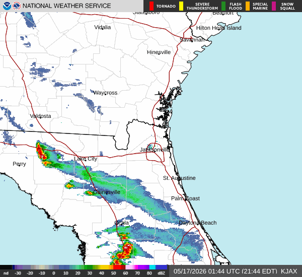
Here is the radar for the Carolinas with some showers over the Outer Banks.
One might think the title is referencing the lack of significant stormy weather in the Jacksonville area, even as the southern US was undergoing another severe weather outbreak, but it is not. Instead, the title references the lack of range in the temperatures, even with an airmass shift coming the way of Jacksonville. The forecasters with the quieter (and warmer overnight) temperatures were the ones that excelled on this day. The Top forecast went to Weatherbug, their first win of the year, after a strong 2021. Actuals: Tuesday: High 80, Low 60 Wednesday: High 82, Low 66
A lot of places in Florida seem like straightforward forecasts, but Jacksonville is far enough north, and not as prone to sea breezes on all sides as the rest o the state. What I am saying is, Jacksonville can be a bit more challenging. Let’s investigate, and see if today is as tough as I promised.
At 956PM, ET, Jacksonville was reporting clear skies and a temperature of 62 degrees. The airport was actually the cool spot in the area, with warmer temperatures south and along the coast. High pressure is firmly entrenched in the eastern third of the United States, and there isn’t a cloud in the sky over the Sunshine State. The ridge will be dislodged through the middle of the week, as a robust trough starts to press out of the Rockies and into the Plains. The skies above Jacksonville will not betray a strong cold front on it’s way towards the city through the day Tuesday and much of the day Wednesday. Some clouds will finally arrive late in Wednesday, with a bit of high overcast, and an increase of winds. The rain and thunder will hold off until Thursday morning. Tomorrow – Sunny morning haze, High 77, Low 57 Wednesday – Increasing clouds late, with some breeze, High 85, Low 59
TWC: Tomorrow – A mainly sunny sky. High 78, Low 56 Wednesday – Sunshine and clouds mixed. High 85, Low 63
AW: Tomorrow – Plenty of sunshine High 79, Low 54 Wednesday – Breezy with more clouds than sunshine High 84, Low 60
NWS: Tomorrow – Sunny, High 79, Low 56 Wednesday – Patchy fog between 7am and 8am. Otherwise, partly sunny, High 84, Low 63
WB: Tomorrow – Sunny, High 77, Low 59 Wednesday – Patchy fog, mostly sunny, High 83, Low 65
WN: Tomorrow – Mostly sunny, High 79, Low 56 Wednesday – Partly cloudy, High 84, Low 63
FIO: Tomorrow – Clear throughout the day. High 77, Low 58 Wednesday – Mostly cloudy throughout the day. High 80, Low 64
It turns out, it wasn’t a particularly adventuresome forecast. Time will tell if it is difficult. Despite how calm things looks for the next 48 hours in Jacksonville, the middle of the country looks to be pretty in line for another round of severe weather. Cold fronts catch the attention of Floridians, and this week will grab some attention. Right now, it’s a good night for stargazing.
North Carolina doesn’t get enough respect as a large state. It will take over 5 hours over 367 miles. We will go at a pace of 66.3mph from the mountains to the sea, and see all that North Carolina has to offer.
Asheville, North Carolina
North Carolina will be on the southern flank of a ridge that is drifting into the Atlantic, just off shore from New York, and the tail of a cold front will trigger some clouds across North Carolina. If we get out of the mountains early enough, we could see some fog. It should clear up after Hickory, but clouds will remain present across North Carolina for the remainder of our drive, and only more so as we sink further south and towards the coast in Jacksonville. Hope we drove to the right one.
Last Monday, we issued a forecast for Jacksonville, that took us through the middle of the week. Some other stuff has happened weatherwise since then. In Jacksonville, an aggressive surge of warm air indicated just what was available for the severe weather that was to come a few days later. Temperatures were, as a result, a bit warmer than most had on their forecast board. Weatherbug had two perfect forecasts, and hung tough thanks to their low temperature forecasts, and snagged the top forecast before all the weather went to hell not far from there. Actuals: Tuesday – High 85, Low 68 Wednesday – .11 inches of rain, High 89, Low 68
We have trekked out to Washington quite a bit recently (including a forecast for Yakima that didn’t quite get published until I noticed it hadn’t gone out right now) but now, we will be going exactly to the opposite side of the country.
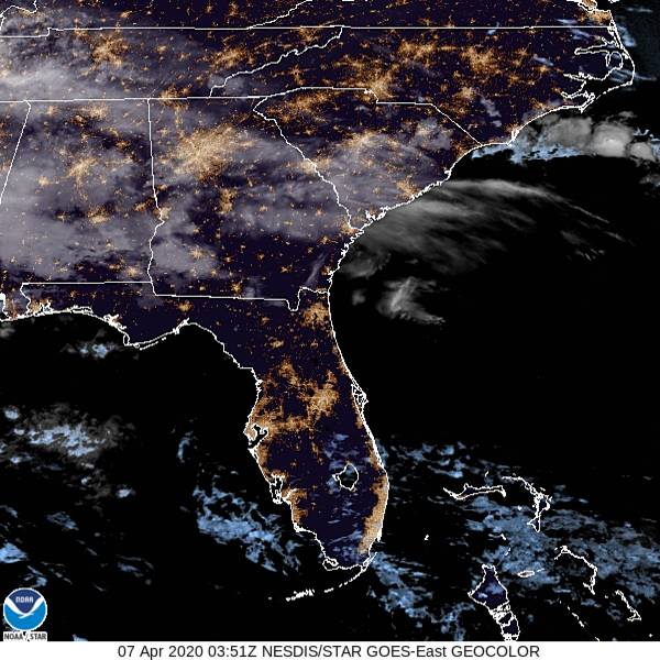
At 1156PM, ET, Jacksonville was reporting a temperature of 63 degrees with mostly cloudy skies. This is likely a bit of an aberration, as most sites across the region are cloud free, and the satellite imagery shows most of the sunshine state enjoying some moonshine tonight. The remnants of a boundary over the southeast lingers from Georgia to Mississippi in the form of some high clouds, though that is all that threatens tonight. High pressure centered northeast of the Bahamas will ensure Jacksonville will stay dry and mostly sunny on Tuesday. There is a weak low level disturbance over the Mississippi Delta that will continue to unravel as it shifts to the east, but Wednesday is going to look a little bit bleaker with a few more clouds and an isolated shot at a shower or thunderstorm. Tomorrow – Mostly sunny, High 85, Low 59 Wednesday – Mostly cloudy with a spot of rain, High 83, Low 67
TWC: Tomorrow – Partly cloudy skies. High 87, Low 63 Wednesday – Partly cloudy with afternoon showers or thunderstorms. High 86, Low 67
AW: Tomorrow – Times of clouds and sun High 85, Low 64 Wednesday – Mostly cloudy and very warm; a thunderstorm in spots in the afternoon High 86, Low 64
NWS: Tomorrow – Sunny High 86, Low 62 Wednesday – A slight chance of showers, then a chance of showers and thunderstorms after 2pm. Mostly sunny, High 88, Low 66
WB: Tomorrow – Mostly sunny in the morning then becoming partly cloudy, High 85, Low 64 Wednesday – Partly cloudy. Slight chance of showers in the morning then chance of showers and slight chance of thunderstorms in the afternoon, High 84, Low 68
WN: Tomorrow – Mostly sunny, High 86, Low 62 Wednesday – Partly cloudy with scattered showers, High 88, Low 66
FIO: Tomorrow – Clear throughout the day. High 86, Low 61 Wednesday – Partly cloudy throughout the day. High 87, Low 67
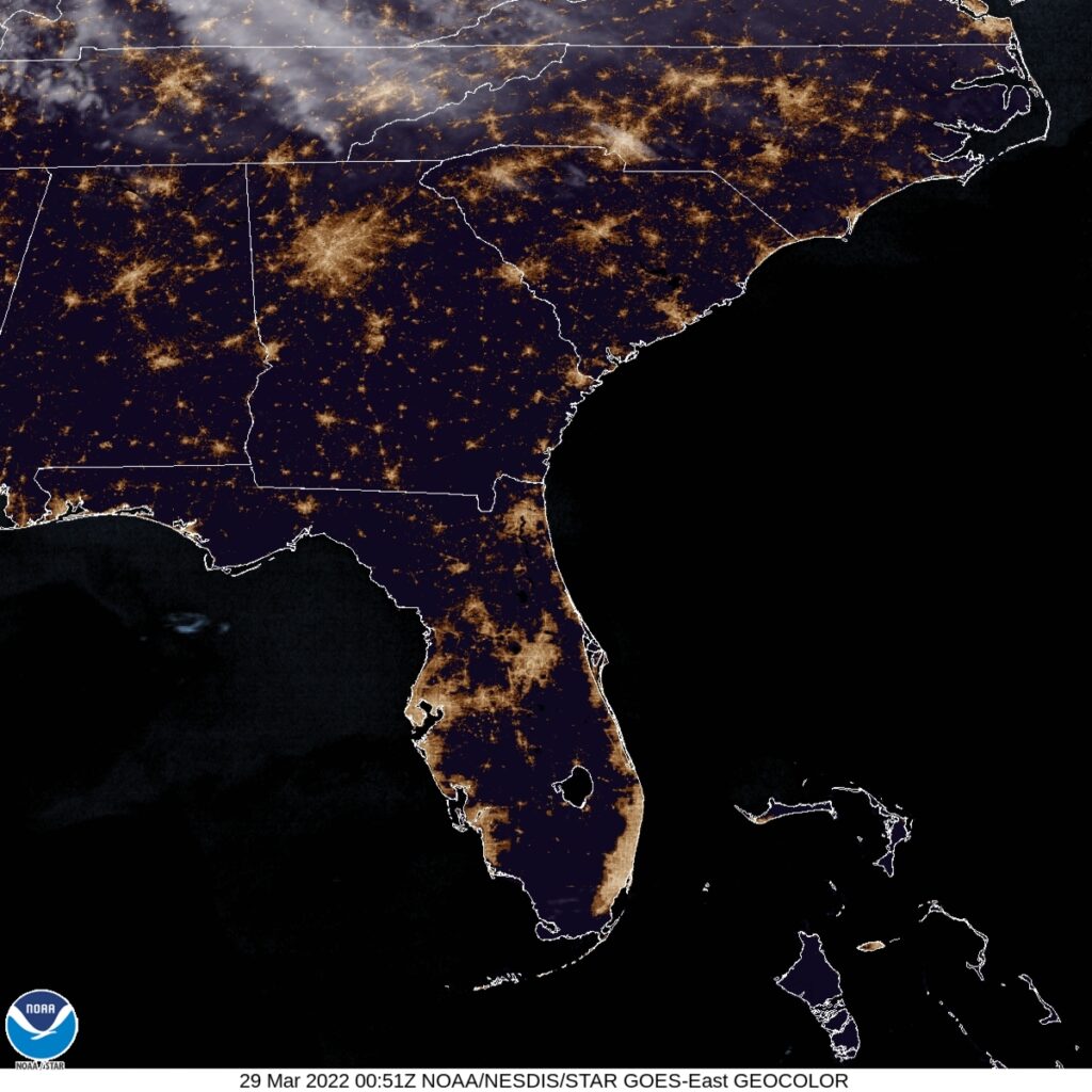
Here is the satellite graphic for the evening. Just a few clouds to the north, while Jacksonville can settle in for the night with no problems.