Bloomington, Indiana

We are only ever so slightly updating our forecast information from our last one. We are going from one state to the next, and not even changing the name of the town.

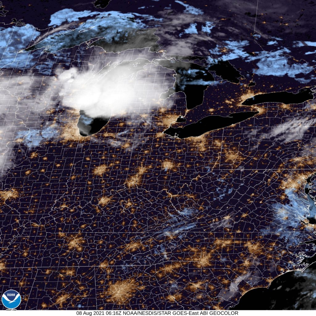
At 756PM, ET, Bloomington was reporting cloudy skies with a temperature 76 degrees. Thunderstorms were popping up from Shoals southeast towards Sellersburg, and they were generally moving away from Bloomington. High pressure is building over the Great Lakes, pushing the last vestiges of a cold front south and across the Ohio River. This should lead to some stability and fairly clear skies tomorrow in Bloomington.
The ridge is small in territory, but will be an effective shepherd, pushing any rising moisture around it and to the east, away from Bloomington. The remainder of the week will be dry for this tract of southern Indiana, but heat will start moving back in even behind the cold front.
Tomorrow – Sunny, High 84, Low 62
Friday – Sunday, a bit warmer, High 86, Low 60

TWC: Tomorrow – Partly cloudy. A stray shower or thunderstorm is possible. High 85, Low 65
Friday – Sunshine and clouds mixed. High 86F. Winds light and variable. High 86, Low 61

AW: Tomorrow – Beautiful with times of clouds and sun High 82, Low 65
Friday – Mostly cloudy High 84, Low 60

NWS: Tomorrow – A 10 percent chance of showers and thunderstorms before 7am. Patchy fog before 7am. Otherwise, mostly sunny, High 84, Low 66
Friday – Mostly sunny, High 84, Low 62

WB: Tomorrow – Partly cloudy. A slight chance of thunderstorms in the morning, High 82, Low 66
Friday – Mostly sunny in the morning, then becoming partly cloudy, High 82, Low 67

WN: Tomorrow – Partly cloudy with light rain showers, High 84, Low 63
Friday – Mostly sunny, High 84, Low 63

CLI: Tomorrow – Light rain showers, High 83, Low 65
Friday – Partly cloudy, High 85, Low 61

Not sure why there is rain in the forecast this morning, but there was some south of town late in the evening. I tried to save an image, but it was corrupted, and now there is nothing going on.

Bloomington, Illinois

It was a very stormy Monday night for northern Illinois, as a derecho swept through, touching nearly every location in the state. Here’s hoping that things return to Normal in the Bloomington area soon.

At 956AM, CT, Bloomington was reporting clear skies and a temperature of 60 degrees, a pleasant morning in the middle of what has been a warm, wet summer. Flow aloft is weak across the country, which will allow things to warm up under the sun, but humidity through the day should remain comfortable.
High pressure will continue to hold through today and to start the weekend on Saturday, however an upper level trough is then expected to rotate in from the Upper Midwest. A mostly disorganized batch of energy will tap into the Gulf of Mexico, pulling in a steady rise in moisture, and contributing to clouds and the potential for a few isolated storms on Sunday evening. These storms won’t match those seen on Monday, instead functioning as weak pop up cells that will end afternoon picnics a bit early.
Tomorrow – Mostly sunny, High 81, Low 58
Sunday – Increasing clouds, and an isolated storm, High 82, Low 63

TWC: Tomorrow – Some sun in the morning with increasing clouds during the afternoon. High 79 Low 57
Sunday – Cloudy. High 80, Low 62

AW: Tomorrow – Partly sunny and delightful High 78, Low 58
Sunday – Comfortable with intervals of clouds and sun High 81, Low 62

NWS: Tomorrow – Partly sunny,  High 80, Low 59
Sunday – Partly sunny, High 81, Low 63

WB: Tomorrow – Mostly sunny, High 77, Low 58
Sunday – Partly sunny, High 78, Low 63

WN: Tomorrow – Partly cloudy, High 80, Low 59
Sunday – Partly cloudy, High 81, Low 64

CLI: Tomorrow – Sunny, High 80, Low 57
Sunday – Mostly cloudy, High 81, Low 60

Look at me, Mr. Negative. I do have warmer temperatures, because it’s July and the sun is out, and I am the only outlet with rain in the forecast. It’s been so wet, why slow down now? Satellite imagery is pretty clear.

Showers and storms are the only relief

We are a nation divided. Any watch of the news will tell you that, but also, we are divided climatologically right now. Its hot and dry west of the Mississippi, and it’s been tolerable but west to the East. Such was the case in Bloomington, Indiana at the beginning of last week, when temperatures were allowed to remain in the 80s, and on Monday, the ground soaked up half an inch of rain. Surely, half the country would appreciate the wealth being shared. Victoria-Weather stepped up and earned the top forecast.
Actuals: Sunday – High 87, Low 67
Monday – .53″ of rain, High 82, Low 69

Grade A-C

Bloomington, Indiana

Let’s just keep piling on forecasts. Right now, let’s head to the home of my alma mater’s number 1 basketball rival, Bloomington, home of the (barf) Indiana Hoosiers.

At 153AM, ET, Bloomington was reporting fair skies with a temperature of 67 degrees. Indiana was enjoying a quiet night, however a weak warm front was proving active over Lake Michigan, with a cold front dangled through the Plains and touching off a broken line of severe weather west of the Mississippi. Dew points were in the 60s across Indiana, and ahead of any advancing showers or storms, Sunday will be humid.
The actual wet weather is going to take until early Monday morning, perhaps in the predawn, to arrive in Bloomington. The timing suggests storms will be rain producers, but won’t necessarily bear a severe threat. The boundary will be a fair sight weaker than it is showing tonight, and will disorganize before arriving. This means that Bloomington will likely have a threat for a shower or thunderstorm throughout the day as the region becomes modestly destabilized, rather than withstanding the sharp transition of a front.
Tomorrow – Mostly sunny, with some clouds building late. High 88, Low 67
Monday – Scattered showers and thunderstorms. High 84, Low 69

TWC: Tomorrow – Intervals of clouds and sunshine. High 89, Low 67
Monday – Scattered thunderstorms. Storms may contain strong gusty winds. High 83, Low 67

AW: Tomorrow – Partly sunny and humid High 90, Low 69
Monday – Intervals of clouds and sun with a thunderstorm in the area; humid High 84, Low 72

NWS: Tomorrow – Mostly sunny High 90, Low 69
Monday – Isolated showers and thunderstorms, then showers likely and possibly a thunderstorm after 8am. Partly sunny, High 84, Low 71

WB: Tomorrow – Mostly sunny in the morning, then becoming partly cloudy, High 87, Low 69
Monday – Showers likely and chance of thunderstorms, High 82, Low 62

WN: Tomorrow – Partly cloudy, High 90, Low 67
Monday – Partly cloudy iwth chance of thunderstorms, High 85, Low 71

FIO: Tomorrow – Humid and partly cloudy throughout the day. High 88, Low 66
Monday – Rain in the afternoon. High 85, Low 70

The weekend looks ok, but the workweek starts dreary. That qualifies as a good forecast, right?