A tough thing about summer when scattered showers or storms are in the forecast, is that if you have them in and they don’t happen, your temperature forecast is likely to be pretty far off as well. This was the case in Sandusky at the end of June, when everyone had showers and storms in the forecast for both Thursday and Friday. Didn’t happen save for a splash on Thursday the 26th, and temperatures soared into the 90s, leaving everyone with frightful numbers. Clime was the warmest outlet, and ended up securing the easy victory. Way to hedge your bets, Clime! Actuals: June 26th, .01 inches of rain, High 91, Low 75 June 27th, High 93, Low 73
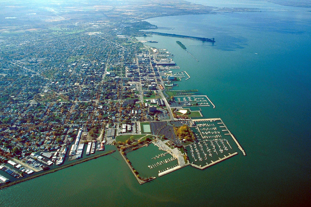
There are a surprising number of large cities in Ohio, and I’m not sure that most people are aware of all of them. Sandusky is the third largest, just on the shore of Lake Erie, however if you are familiar with Cedar Point Amusement Park, you probably have heard of Sandusky.
At 455PM, ET, Sandusky was reporting a temperature of 86 degrees with overcast conditions. There was a smattering of thunderstorms across Ohio, Michigan and Lake Erie, including a few that were producing severe hail. The nearest was a storm about 20 miles south of Sandusky, drifting to the southeast. This was all a part of a slow moving warm front across the Great Lakes, which was keeping the area from the historic heatwave in the Eastern US, but also allowing for the severe storms. The pattern in the northern Plains, at least over the lower levels, will continue to be unsettled, but the jet structure is going to lift north and away from there. The instability in the Plains will work with the heat and humidity under the jet ridge in the east, lifting north and continuing to bring thunderstorms to the Sandusky area. A surface trough will drift through the area late on Friday, bringing the best chance of thunderstorms. Tomorrow – Mostly cloudy with scattered storms, High 85, Low 73 Friday – Partly cloudy, a few afternoon and evening storms, High 88, Low 75
TWC: Tomorrow – Sun and clouds mixed with a slight chance of thunderstorms during the afternoon. Hgh 86, Low 71 Friday – Intervals of clouds and sunshine. A stray afternoon thunderstorm is possible. High 91, Low 75
AW: Tomorrow – Warm and very humid with a thunderstorm in the area; cloudy in the morning, then times of sun and clouds in the afternoon High 86, Low 71 Friday – Very warm and humid with variable cloudiness; a thunderstorm in a couple of spots in the afternoon High 89, Low 73
NWS: Tomorrow – A slight chance of showers, then a chance of showers and thunderstorms after 11am. Mostly sunny, High 86, Low 72 Friday – A chance of showers and thunderstorms, mainly after 2pm. Mostly sunny, High 89, Low 74
WB: Tomorrow – Partly cloudy with a chance of thunderstorms. A chance of showers. High 85, Low 75 Friday – Partly cloudy with a chance of showers. A chance of thunderstorms in the afternoon. High 87, Low 76
WN: Tomorrow – Partly cloudy with showers and a chance of storms, High 86, Low 72 Friday – Partly cloudy with scattered showers and a chance of storms, High 89, Low 74
CLI: Tomorrow – Thunderstorm, High 90, Low 73 Friday – Light rain showers, High 93, Low 75
Clime is going on the warm side, even tomorrow. Here is a look at the radar, with that storm to the south of Sandusky.
An under reported facet of the weather and forecasting in general is the wind direction. It stands a bit more at the forefront when lake effect snow is at play, as it was in Sandusky. The snow that was in the forecast lingered until the early afternoon on Friday, despite thoughts it would conclude on Thursday. Nobody had the snow right, so it came down to temperatures, and Victoria-Weather took the victory. Actuals: Thursday – Snow reported, not measured, High 25, Low 14 Friday – Snow reported, not measured, High 30, Low 21
The Great Lakes during a cold stretch in February, in the midst of some breezy conditions in the region. I have a pretty good guess on how things are going.
At 1053AM, ET, the Sandusky area was seeing clear skies and a temperature of 16 degrees. There were a few flurries throughout the region, thanks to lingering westerly winds. Another gnarly storm system is bringing heavy rain to the southeastern US. This is adding some moisture to the region, but by tonight, will inhibit flow into a trough moving into the region. The trough is weak, and riding the front edge of a strong ridge in the center of the country. It will bring a few flurries to Sandusky overnight and into the early morning tomorrow. The wind in the area may lead to some lake effect flurries that last into the early afternoon, but high pressure will squash the moisture out of the region by Friday. Expect sunny skies as the weekend rolls in. Tomorrow – A few flurries, perhaps accumulating to an inch, wrapping up in the afternoon. High 24, Low 13 Friday – Clearing and a bit warmer, High 27, Low 15
TWC: Tomorrow – Cloudy with snow showers mainly during the morning High 22, low 14 Friday – Cloudy. Very cold. High 27, Low 15
AW: Tomorrow – Very cold with snow and flurries at times, accumulating a coating to an inch, becoming breezy in the afternoon; roads could be slippery for the morning commute High 21, Low 13 Friday – Quite cold with low clouds; a warmup is on the way High 26, Low 15
NWS: Tomorrow – A chance of snow showers, mainly before 11am. Cloudy, High 22, low 14 Friday – Partly sunny High 27, Low 12
WB: Tomorrow – Cloudy. A chance of snow showers mainly in the morning. Snow accumulation up to 1 inch possible. High 20, Low 15 Friday – Partly sunny, High 24, low 18
WN: Tomorrow – Mostly cloudy with snow showers, High 22, Low 14 Friday – Partly cloudy, High 27, Low 13
CLI: Tomorrow – Heavy snow showers, High 21, Low 13 Friday – Overcast, High 26, Low 14
Given that it was -11 here this morning, the third double digit below zero morning in a row, it’s funny to see multiple outlets refer to the mid 20s as “cold”, needing to call it out like that. The radar shows an impressive amount of coverage, but it won’t add much in terms of accumulation.
The start of June was proceeding just fine on Monday, but then after a little warm front brought a scant amount of precipitation to Sandusky overnight, Tuesday was very different. Amid forecast highs that were supposed to be in the upper 70s to low 80s, opportune clear skies led to a high of 90. Nope, nobody was close. The Weather Channel had the top forecast, simply on the merits of having the warmest forecast on Tuesday. Actuals: Monday, Trace of rain, High 73, Low 50 Tuesday – .04 inches of rain, High 90, Low 59
It’s hard to believe the couple of months we have been through as a country. Hopefully, it is an inflection point in our history, towards justice and understanding.
At 255PM, ET, Sandusky was reporting clear skies and a temperature of 55 degrees. A solid dome of high pressure was centered over the eastern Great Lakes and Ohio Valley, with little threat of being dislodged today. A sharp, fast moving trough will slide into the Great Lakes through the day tomorrow, with some showers and thunderstorms following suit. At the surface, there is expected to be enough penetration into the surface ridge that some of those showers and storms will clip Sandusky overnight Monday into Tuesday, with some slow moving showers and clouds on Tuesday morning. The ridge will linger to the south, so sunny skies should return by afternoon. Tomorrow – Mostly sunny, late rain. High 72, Low 46 Tuesday – Overcast early with a spot of rain, then sunny in the afternoon. High 81, Low 51
TWC: Tomorrow – Sunny, along with a few afternoon clouds. High 73, Low 47 Tuesday – Sunshine and clouds mixed. Slight chance of a rain shower. High 84, Low 60
AW: Tomorrow – Partly sunny and warmer, High 71, Low 47 Tuesday – A shower or thunderstorm early in the morning; rather cloudy and humid High 77, Low 61
NWS: Tomorrow – Sunny High 71, low 48 Tuesday – A chance of showers and thunderstorms before 2pm, then a slight chance of showers. Partly sunny High 80, Low 61
WB: Tomorrow – Sunny, not as cool, High 71, Low 49 Tuesday – Mostly cloudy in the morning, becoming partly sunny, 40 percent chance of showers, High 77, Low 62
WN: Tomorrow – Partly cloudy, High 70, Low 48 Tuesday – Mostly cloudy with scattered storms, High 78, Low 61
FIO: Tomorrow – Clear throughout the day. High 70, low 49 Tuesday – Mostly cloudy throughout the day. High 79, Low 62
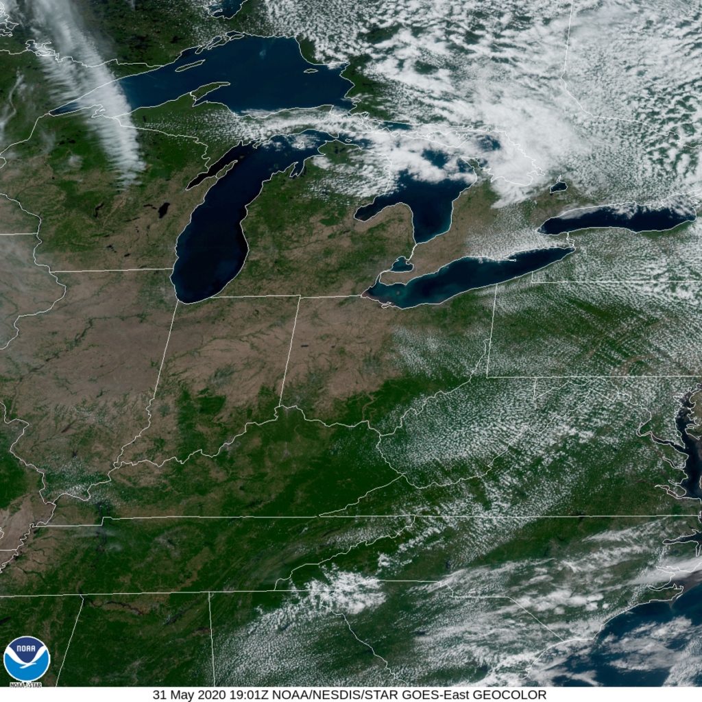
Here is the satellite, showing a very nice end to the weekend across the Great Lakes.
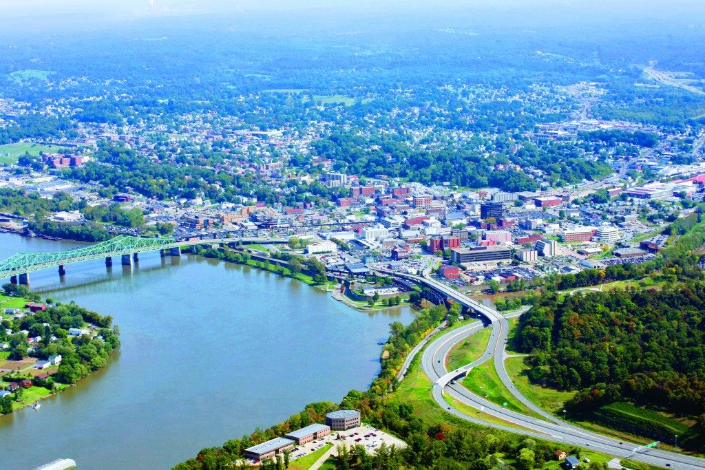
Today we embark on a quick little road trip, just 229 miles separate these 2 cities, and it’ll take barely longer than 1 viewing of Avengers: Endgame to get there. Don’t even need to pack snacks for this trip (but we will anyways)
As a frontal boundary sits over southern Michigan and slowly sags southward during the day, some scattered rain shower activity is expected over northern OH throughout the day. It’ll be a dry start to the trip travelling north from Parkersburg, but the closer we get to the lakefront, the more likely we’ll see a scattered shower or two across our route. Nothing particularly heavy is expected, just the weather being a little annoying.