March was not a busy month here at Victoria-Weather, at least on the forecast side. We had plenty of updates and weather discussions, but the forecasting was light. Therefore, it is tough to split the difference between our two top options for Forecaster of the Month: The Weather Channel and Clime.
Baltimore had about a perfect set of spring days. Sure, you could ask for temperatures to be a bit warmer, but in early April, 50s are perfectly reasonable. This was exactly what happened last Wednesday and Thursday. Temperatures never dipped below freezing, but nights were still cool, and it didn’t get too hot. 50s, perhaps, are too chilly for residents of Maryland, but they sure have an fan club, and besides, warmer temperatures are going to be in place for the next several months. Speaking of drawing a fan club, three outlets drew level for this forecast: Accuweather, The Weather Service and WeatherNation had a collective win, but the consensus forecast was actually a smidge better than even them.. Actuals: Wednesday, High 51, Low 33 Thursday – High 59, Low 33
Storms are expected to erupt across the middle of the country over the next couple of days, with an otherwise warmer trend. It is spring, after all. At last. On to the future forecasts.
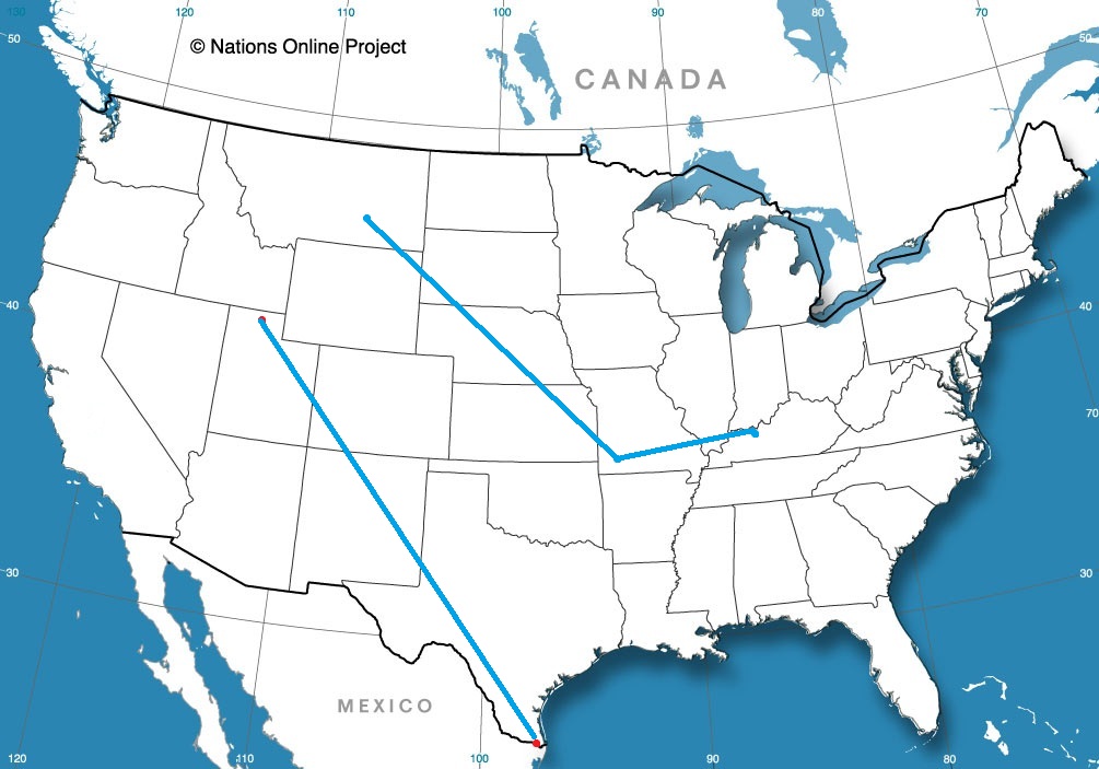
Road Trip from Owensboro, Kentucky to Springfield, Missouri.
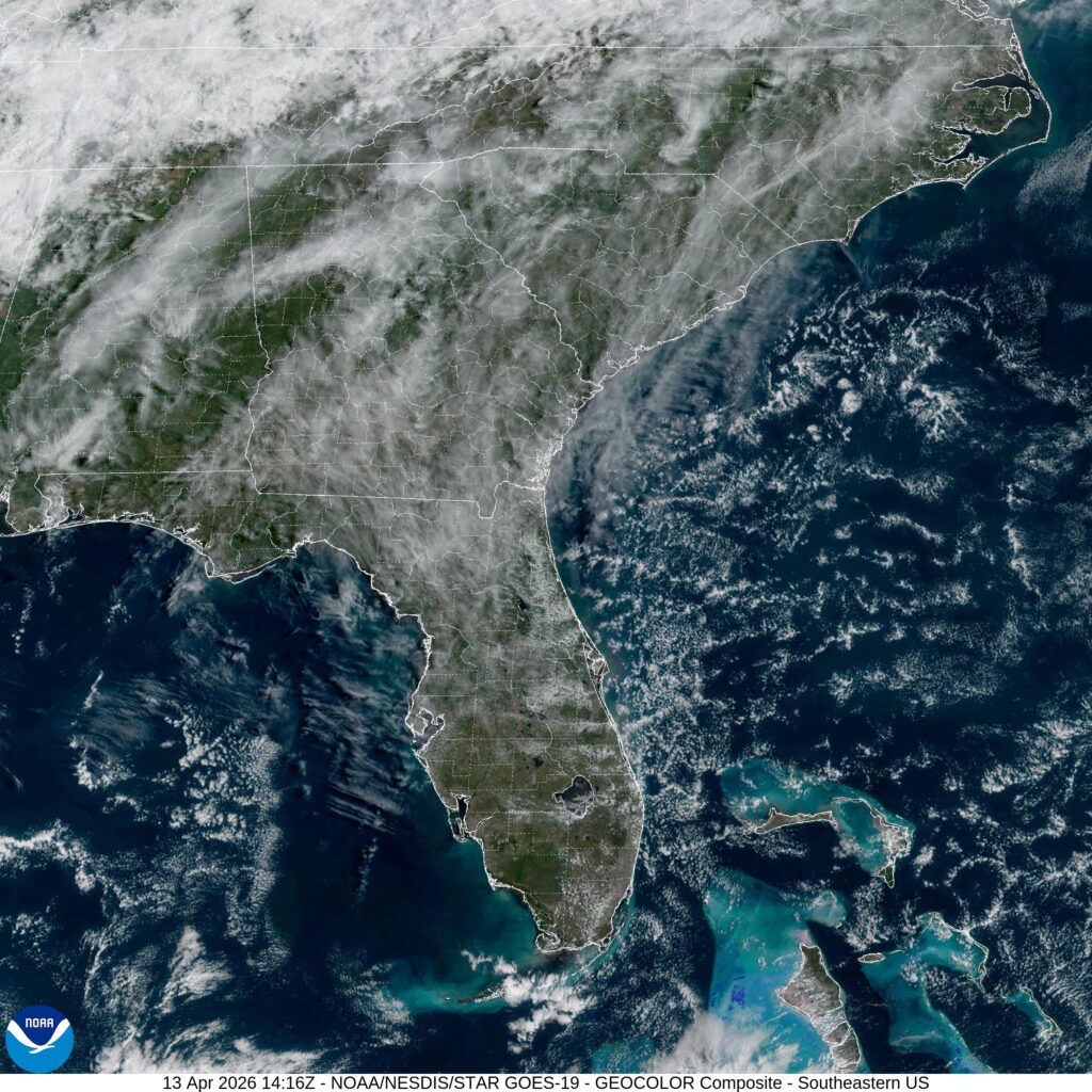
We are headed down to the Carolinas today. As things get warmer, weather is starting to get more convective. Will that be the case in North Carolina?
At 1010AM, ET, Fayetteville was reporting scattered clouds and a westerly breeze gusting to about 20mph. Elsewhere in the area, dew points of over 60 were leading to some haze, which the wind was doing a good job of scouring. There is a boundary to the west of the Appalachians that is in the process of fading, but has done an effective job of drawing warm moist air into the Carolina coastal plains. That boundary is fading as low pressure deepens in the northern Plains. This will reinforce both the jet ridge over the east coast, and the warm, oceanic air in Fayetteville. Clouds will increase with the temperature, but a dry couple of days are anticipated. Tomorrow – Mostly sunny, High 88, Low 59 Wednesday – Partly cloudy, High 91, Low 61
TWC: Tomorrow – Mostly sunny skies. high 89, Low 60 Wednesday – Generally sunny. Near record high temperature High 92, Low 62
AW: Tomorrow – Partly sunny and very warm with the temperature tying the record high from 1922 High 92, Low 59 Wednesday – Partly sunny and hot with the temperature approaching the record high of 95 set in 2006; caution advised if doing strenuous activities outside High 94, Low 61
NWS: Tomorrow – Sunny, High 89, Low 61 Wednesday – Sunny, High 92, Low 64
WB: Tomorrow – Mostly sunny. High 86, Low 65 Wednesday – Sunny hot High 89, Low 67
WN: Tomorrow – Mostly Sunny, High 89, Low 61 Wednesday – Mostly sunny, High 92, Low 64
CLI: Tomorrow – Sunny, High 88, Low 58 Wednesday – Partly cloudy, High 91, Low 61
Easy peasy. Satellite shows some scattered clouds across the southeast.
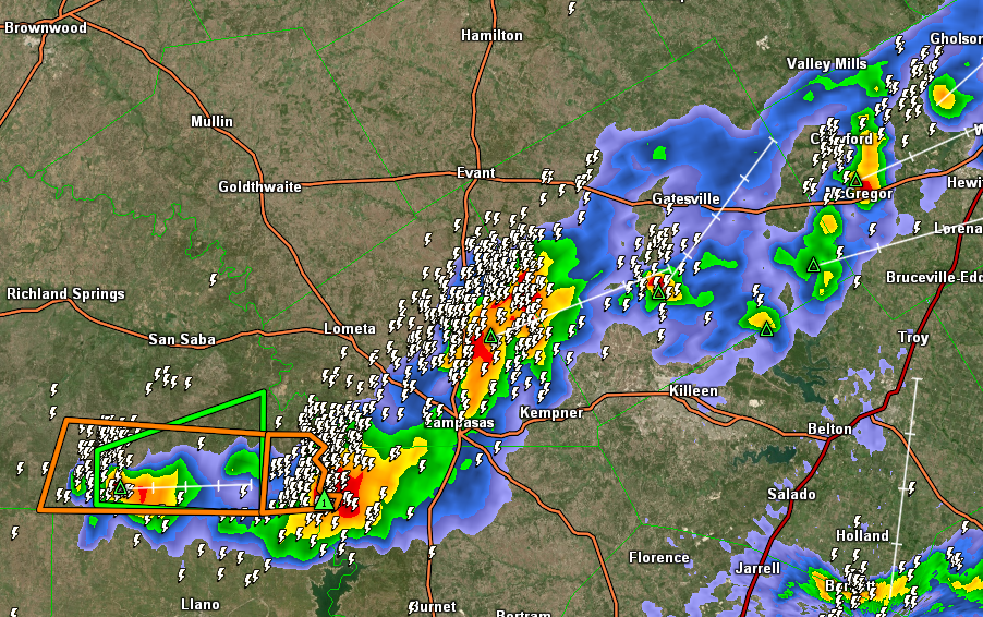
12:33AM: We’re looking at a busy week of storms. High pressure hangs over the mid-Atlantic, with warm air pumping into the Plains. Storms are a consistent threat in the middle of the country for the next few days.
4:55PM With the gusty winds found posrt frontally, and it being as dry as it is regionwide, expect an elevated fire risk for the Plains all week. Red flag warnings are out for many spots
10:53PM Storms are dying out in Texas this evening, but good luck getting sleep. Look at all this lightning
Just before Easter, we went to the Central Valley of California. Visalia was warm, but clear overnight skies meant the weather was sleepable. Records were not ultimately set, which was how the official forecasts played out. There was a tie at the top between Accuweather and Clime, and a good score for everyone. Actuals: Sunday, High 88, Low 49 Monday, High 87, Low 52
It’s only going to take 5 hours to travel from the Inner Harbor to the Ohio Valley, but boy, things are going to be world’s different, culturally and scenically. What about climatologically? That is why I am here! This drive is going to cover about 319 miles, as I said for roughly 5 miles. That means a pace of about 64.9mph, slowed by city driving and hilly terrain.
Baltimore, Maryland
A cold front is going to move through the region overnight tonight, but it isn’t a strong cold front, and it is reinforced by a stout little batch of high pressure. This will allow things to clear out nicely as we run the length of Maryland, eventually crossing directly into West Virginia. The temperature should rebound a bit as well, given the sun, and post boundary fog won’t be wide spread. If only it was a bit greener, this might be the perfect drive.
10:35PM: The burden for above normal warmth has shifted to the southeastern US for the time being. Instead of heat out west, there is a chance for mountain snow early next week in the northern Rockies.
7:35PM: There is a “minor heat risk” for the Central Valley in California. At least it’s minor. But what’s this? There is also a winter weather advisory in the Sierras. California contains multitudes.
We have finally left California, and now we head to the opposite coast. We don’t see enough of Baltimore, if you ask me. The Inner Harbor is wonderful.
At 1054PM, ET, Baltimore was reporting a temperature of 43 degrees with clear skies. The DC and Baltimore reporting sites were anomolous to the region, with temperatures in the mid to upper 30s nearby. Clear skies and low dew points suggest that Baltimore will see a chilly morning tomorrow. There are freeze warnings out regionwide. The pattern is conducive to a spring cool down, with a subtropical low in the Bight of Georgia and high pressure centered over the eastern Great Lakes. An upper level ridge is close behind, however, and while Wednesday will start cool, it will warm up nicely. Thursday looks like it could be spectacular. Tomorrow – Sunny, High 54, Low 30 Thursday – Sunny, High 62, Low 36
TWC: Tomorrow – Sunny High 54, Low 33 Thursday – Partly cloudy skies. High 61, Low 37
AW: Tomorrow – Plenty of sun, but cool High 52, Low 32 Thursday – Times of clouds and sun High 58, Low 37
NWS: Tomorrow – Areas of frost before 9am. Otherwise, sunny High 53, Low 33 Thursday – Mostly sunny, High 59, Low 38
WB: Tomorrow – Areas of frost in the morning. Sunny. High 50, Low 34 Thursday – Areas of frost in the morning. Mostly sunny High 54, Low 35
WN: Tomorrow – Sunny with areas of frost, High 53, Low 33 Thursday – Partly cloudy, High 59, Low 38
CLI: Tomorrow – Sunny, High 54, Low 34 Thursday – Mostly cloudy, High 57, Low 37
I’m the most optimistic about the power of insolation, it appears. Time will tell. Right now, clear skies on the coast, with clouds off shore.