Dothan stays dry, gets cool

For the second time in the day, we had a forecast where many outlets called for rain, and I couldn’t figure out why. In Cleveland, there was a little bit of rain, just as the forecast period started, but in Dothan, the rain was indeed long out of town. The cool air behind the rain was there too, with temperatures dipping a little bit below where V-W had forecast, which opened some daylight, and another outlet who forecast a dry period in Dothan, Forecast.io, ended up securing victory.
Actuals: Friday, High 86, Low 67
Saturday – High 85, Low 63

Grade: A-C

Los Angeles, California to Sioux Falls, South Dakota

We are destined for a three day trek across the western US for our forecast today. This route includes forays along roads that we don’t often see, especially in Wyoming and South Dakota, so that is kind of fun. Also, the idea of an Angelino in South Dakota makes me chuckle. The mileage between the two towns is 1677 miles, and our travels along several highways with 80mph speed limits will allow for a pace of nearly 70mph overall, and 559 miles of ground covered every day. Pretty sweet for a long trip.

DAY ONE (Tuesday)

Los Angeles, California

I’m not sure there is an actual location where you can take a picture of downtown Los Angeles with Mount Baldy looming in the background like this, but it’s what most pictures of downtown LA look like, so there must be something. The drive through California into the Lake Havasu area, where we will really start to turn to the north. A massive storm system is moving into the middle of the country and will bring more severe weather to the Plains, but also, significantly, will bring some snow to the Wasatch as we drive just to the east of them on I-15. We’ll stop in Holden, Utah, watching the peaks whiten overnight. Kind of like this picture of Mount Baldy.

DAY TWO (Wednesday)
The strong storm will barrel its way out of our route by the time we get moving on Wednesday, but bear in mind that this will be the first winter storm of the season, so even though we are on the interstates, the roads in the passes may still be a little slick. Nothing fresh will be falling through northern Utah or across the vast expanse of Wyoming that we will cover. We will end the day in the paper town of Savageton, which is about 2/3 of the way from Casper to Gillette.

DAY THREE (Thursday)
Moving through the Black Hills should be a bit easier than the Rockies and Wasatch were. They are lower, and probably won’t see as much snow, especially at the level I-90 passes through the region. Then, after Rapid City, South Dakota will feature boundless fields of pastureland, and a heck of a lot of sunshine and, most importantly, a speed limit of 80mph.

Sioux Falls, South Dakota

Sioux Falls, South Dakota

We’re going to the Dakotas this evening. There was a little bit of rough weather in South Dakota last night. Will the start of the work week bring more of the same?

At 756pm, CT, Sioux Falls was reporting a temperature of 55 degrees with clear skies. There was a complex series of of low pressure bringing rain and areas of strong thunderstorms from the Canadian border and further south, particularly in Oklahoma and Texas, but a swath of clear and cool air had built into the Dakotas.
The next trough will rotate into the central Plains after diving out of the Rockies, and is going to bring with it a strong batch of cold air, and quite a bit of vorticity, winding up what will likely be the largest storm of the season. Expect that by late Tuesday, flow will become robustly southerly, with rain starting late in the afternoon and evening. Very windy conditions are expected Tuesday night, with rain heavy in spots.
Tomorrow – Mostly sunny, High 71, Low 42
Tuesday – Sunny early, then rainy with very strong winds, even outside o thunderstorms, High 72, Low 41

TWC: Tomorrow – Sunshine and clouds mixed. High 72, Low 44
Tuesday – Plentiful sunshine High 71, Low 43

AW: Tomorrow – Pleasant and warmer with intervals of clouds and sunshine High 72, Low 45
Tuesday – Partly sunny and comfortable (late rain) High 70, Low 44

NWS: Tomorrow – Sunny High 71, Low 44
Tuesday – Sunny, High 70, Low 45

WB: Tomorrow – Sunny, High 71, Low 46
Tuesday – Sunny, High 70, Low 46

WN: Tomorrow – Mostly sunny, High 71, Low 44
Tuesday – Mostly sunny, High 69, Low 44

FIO: Tomorrow – Clear throughout the day. High 71, Low 45
Tuesday – Clear throughout the day. High 70, Low 45

It’s not a matter of if, but when it will rain in Sioux Falls. At least they aren’t in Wyoming and Montana, where snow is likely. And at least for tonight, it’s pretty OK.

Done in early

I was brave and bold with the forecast for Cleveland. I had no rain in there, and for the predominance of residents in the area, I’m sure they thought that forecast was spot on. But no, a heavy rain storm was in the area for the first hour of the day on Thursday. They had .87″ of rain before 1AM on Thursday, and then it was mostly done for the rest of the week. That counts as a busted forecast for me, and Victoria-Weather fell out of contention. The Weather Channel would have won the day regardless. I’m not sure if that is a consolation or not.
Actuals: Friday: .87″ of rain in thunderstorms, High 81, Low 63
Saturday – High 81, Low 57

Grade: B-C

Los Angeles, California

There are so many cities in the US, and we forecast for all of them, it’s always surprising for some reason when one of the big cities of the country gets pulled. Let’s forecast in LA!

At 753PM, PT, Los Angeles was reporting a temperature of 64 degrees with partly cloudy skies. Dew points were a little on the high side for the Los Angeles basin, lingering in the 60s near the coast and to the mid 50s inland. A deeply angled jet trough lies over the southwestern US, and it was evidenced by the stream of clouds from Los Angeles to Lake Havasu and south towards the Mexican border.
This jet trough will rotate away from southern California, bringing more sunny skies to the picture. This will allow for some warmth to build back in. Breezy conditions may arise on Saturday, but quieter winds are expected for Sunday.
Tomorrow – Partly cloudy, some morning fog, High 71, Low 58
Sunday – Partly cloudy, High 77, Low 57

TWC: Tomorrow – Sunny skies. High 72, Low 55
Sunday – Mainly sunny. High 81, Low 55

AW: Tomorrow – Mostly sunny and cool, High 72, Low 54
Sunday – Sunny and pleasant High 80, Low 57

NWS: Tomorrow – Sunny, High 73, Low 54
Sunday – Sunny, High 80, Low 56

WB: Tomorrow – Sunny, High 71, Low 55
Sunday – Sunny, High 78, Low 55

WN: Tomorrow – Mostly sunny, High 74, Low 54
Sunday – Sunny, High 81, Low 57

FIO: Tomorrow – Clear throughout the day. High 78, low 56
Sunday – Clear throughout the day High 61, Low 57

Next week is going to be a pretty interesting week in California, with rain and even snow in the mountains. Yowza.

Dothan, Alabama

A second forecast for the day, but there shouldn’t be much controversy with this one.

At 1053PM, CT, Dothan was reporting a temperature of 75 degree with overcast skies. The overcast will help sustain warmer temperatures through the night, and dew points that also sat in the mid 70s foretell of fog. The clouds are low based and low topped, and should diminish with sunshine on Friday. The remnants of a boundary running north-south through Georgia was touching off some thunderstorms in the Peach State, but the threat for rain had passed in southern Alabama.
An organizing area of low pressure off the coast of Georgia will draw the moisture presently in Georgia mostly off shore, and certainly away from Alabama. Expect a dry weekend in Dothan, but the humidity is more than likely to stay elevated.
Tomorrow – Fog early, then clearing and sunny, High 84, Low 72
Saturday – Sunny with less haze in the morning, High 85, Low 66

TWC: Tomorrow – Partly cloudy, slight chance of a rain shower, High 86, Low 70
Saturday – Mostly sunny skies. High 85, Low 64

AW: Tomorrow – A couple of morning showers and a thunderstorm; otherwise, partly sunny High 85, Low 71
Saturday – Pleasant with sunshine and a few clouds High 84, Low 65

NWS: Tomorrow – A 20 percent chance of showers and thunderstorms before 10am. Patchy fog before 9am. Otherwise, mostly cloudy, then gradually becoming sunny, High 84, Low 70
Saturday – Sunny, High 84, Low 65

WB: Tomorrow – Mostly sunny, a chance of showers and thunderstorms in the morning, High 84, Low 70
Saturday – Sunny, High 85, Low 65

WN: Tomorrow = Partly cloudy with isolated storms, High 84, Low 71
Saturday – Mostly sunny, High 84, Low 65

FIO: Tomorrow – Humid and partly cloudy throughout the day. High 84, Low 69
Saturday – Clear throughout the day. High 84, Low 63

I rea;;y am not sure where the rain is coming from in the forecasts for Dothan. Sure looks quiet right now.

Cleveland, Tennessee

Cleveland is one of the towns in a busy corridor of eastern Tennessee. It’s closer to Chattanooga than any other town, and nowhere near Lake Erie.

At 150PM, ET, Cleveland was reporting a temperature of 79 degrees with partly cloudy skies. The upper level feature that brought some severe weather to the region yesterday has deteriorated and started spiraling back towards the western Great Lakes. Westerly flow at the south end of the circulation is driving up the Appalachians, and is producing some extra overcast and rain in the region, but at the surface, dry high pressure is pressing in from the southwest.
An upper level trough will shift off the Georgia coast and will aid in the development of a feature in the Gulf of Georgia. It is expected to develop quickly, and is being monitored for tropical development. The focused circulation around this feature is going to clear out the environment on shore for most of the region. Rain will fall in the Coastal Carolinas, but Cleveland will be dry.
Tomorrow – Partly cloudy, High High 78, Low 66
Saturday – Mostly sunny, High 81, Low 60

TWC: Tomorrow – A shower or two around the area in the morning, then partly cloudy in the afternoon. High 80, Low 66
Saturday – Sunshine and clouds mixed. High 81, Low 60

AW: Tomorrow – A passing shower in the morning; otherwise, humid with a blend of sun and clouds High 81, Low 67
Saturday – Mostly sunny and nice High 82, Low 61

NWS: Tomorrow – A slight chance of showers and thunderstorms before 1pm, then a slight chance of showers between 1pm and 2pm, then a slight chance of showers and thunderstorms after 2pm. Patchy fog before 10am. Otherwise, mostly cloudy, then gradually becoming sunny, High 78, Low 64
Saturday – Mostly sunny, High 79, Low 60

WB: Tomorrow – Patchy fog in the morning. Mostly cloudy with a slight chance of sowers and thunderstorms in the morning, then sunny with a chance of showers and thunderstorms in the afternoon. High 78, Low 65
Saturday – Sunny, High 80, Low 60

WN: Tomorrow – Partly cloudy with isolated showers and isolated storms, High 78, Low 64
Saturday – Mostly sunny, High 80, Low 59

FIO: Tomorrow – Rain overnight. High 79, Low 63
Saturday – Partly cloudy throughout the day. High 79, Low 58

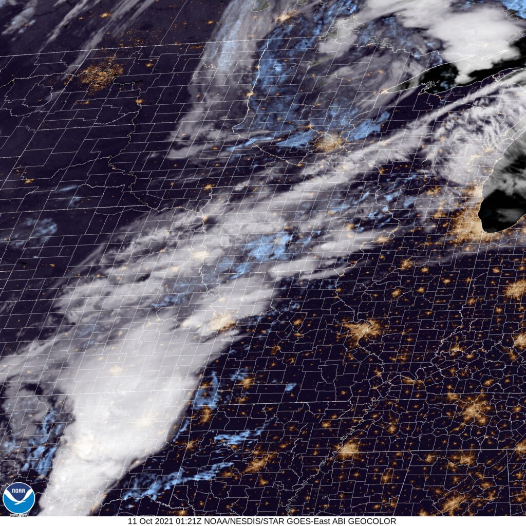
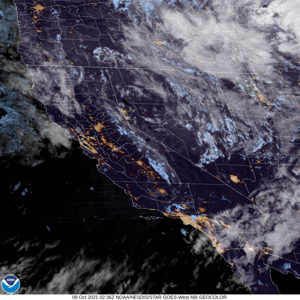
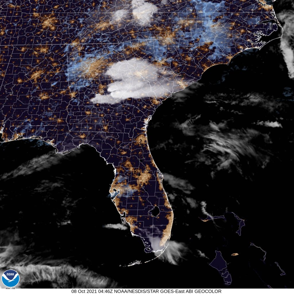
I’m going to stay out on my limb, with no rain in the forecast. Right now, rain is moving through the Smokey Mountains, and isn’t backing down the mountains towards Cleveland and Chattanooga. It seems unlikely that that would change, right? Anyways, here is the satellite imagery. There is rain, as I noted, up hill and east of Cleveland. Note the clouds off shore, as that is our pending potentially tropical feature.

Is a late season tornado outbreak on the way?

There is a tornado watch ongoing this evening from southeastern Tennessee to northeastern Alabama. The threat is localized to the region, and while significant for the region, it doesn’t qualify as an outbreak. Today’s feature is born of a lower level, cut off area of low pressure that doesn’t have a lot of juice to keep it sustained.

Later this week, a more formidable feature is forecast to emerge in the Plains. A sharp area of low pressure that also threatens too become cut off will develop with a little bit more jet support over Oklahoma, Kansas and other nearby states. The sharply cut off low will have a shortwave and a resulting rapid propagation, and as a result will diminish fairly quickly in the Ohio Valley.

Still, even on Day 5 (Sunday), the Storm Prediction Center already has a splotch on the map to be monitored for severe weather. The likely turning in the atmosphere, and the clashing airmasses of a changing season make tornadoes a strong possibility.

Another thing that will usher this shorter — but still active — wave out of the Plains is another, strong, longer waved trough that, even though it is still a week out, the SPC is concerned about. The surface low is forecast to be much more ferocious, with strong winds, rain and perhaps even more thunderstorm activity in the Plains.

This is going to be a very fall like feature, which means windy and rainy in the Upper Midwest. Further to the south, there will be tornadoes in a similar region as on Sunday, but gusty straight line winds will be a problem as well. A well defined cold front will sweep through the southern Plains, which usually means lines of thunderstorms rather than supercellular tornadic storms.

Nevertheless, I would expect the severe picture to clear up as models get better and we get closer to time. An initial instinct for me is that the zone for severe weather will include portions even further north by next Tuesday and Wednesday, perhaps as far as South Dakota. For now, here is the map:

It’s been a very quiet year for severe weather of the traditional variety, but it looks like October will change things. Not only will the next week change our fortunes, it will also change our weather. Don’t be surprised if next Tuesday’s storm is the one that ushers a real dose of autumnal air.

The Appalachians — Lower than expected

The forecast was pretty clear. The majority of our outlets thought that Sunday would be an entirely dry day in Roanoke, because moisture associated with an area of low pressure in the Tennessee Valley seemed like it would get pinned on the west side of the mountains, at least for another day. A couple of outlets, including The Weather Service and Weatherbug, thought a little bit of rain would spill over those hills. In the end, it was a pretty good shot of rain, about 2 tenths of an inch, that fell on Roanoke. Not great! Except, I suppose, for the Weather Service, who coasted to victory.
Actuals – Saturday – High 82, Low 54
Sunday – .19 inches of rain, High 81, Low 62

Grade: A(somehow)-C