Laredo, Texas to Lima, Ohio

It’s the depths of winter for a lot of us, but this is close to the time that the southern US starts to wake up for Spring. We’ll traverse the heart of the USA for our 3 day trip from Texas to Ohio. It’s a 1,488 mile journey, at a pace of 67mph, which will lend itself to a 537 mile drive on the first two days of our trek. We’ll finish the drive on a shorter day in order to enjoy all that Lima has to offer.

DAY ONE (Saturday)
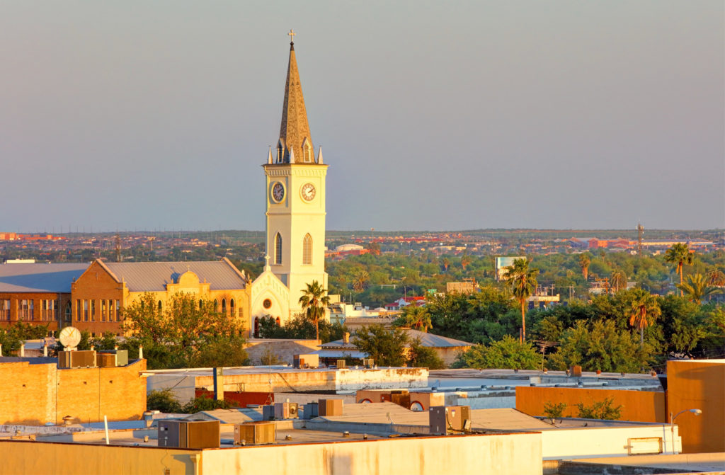
Laredo is the county seat of Webb County, Texas, United States, on the north bank of the Rio Grande in South Texas, across from Nuevo Laredo, Tamaulipas, Mexico.

Another surge if cold air is headed for Texas this weekend. An area of low pressure is going to bring heavy snow to the Great Lakes, but for our drive tomorrow, the trailing cold front will arrive in Texas early in the day. Rain will squeeze out in front of the boundary, but that should hold off until we get to Austin. After that, wind and light rain will be a concern through the early afternoon. Some wet snow could mix in before the rain ends while we approach Dalls. Clearer conditions will try to press in by the end of the day, but expect it to be chilly, and for some slick, icy spots on the roads. We’ll end the day in Winfield, Texas

DAY TWO (Sunday)
So much for the hints of spring I was hoping for. It’s still going to be cold for our route through the south central US. The deepest part of the thermal trough will align, essentially, with our route on Sunday, but fortunately, the precipitation will be confined well south of our route, closer to the Gulf Coast. The day will end in Bellevue, Tennessee, a southwest suburb of Nasville.

DAY THREE (Monday)
Another clipper is going to scoot through the Great Lakes to start the week, another in a series of similar features. This one will ride a bit further north of the tracks that have been in place lately, and won’t likely bring snow to Lima. Fortunately, Lima is in the one spot of northern Ohio that isn’t susceptible to lake effect snow, so expect some clouds, but a pretty generic winter day in Lima when we arrive.

Lima, Ohio

Lima, Ohio

Sure I’m up late, but the Olympics are in Beijing, and on TV at all the wrong times. Speaking of the Olympics, these are the winter games, and Lima will get pretty wintry as we wrap up the week.

At 1253AM, ET, Lima was reporting a temperature of 37 degrees with mostly cloudy skies. The southern end of a Canadian trough is moving through the Lima area tonight, but will be out of the hair of Lima residents entirely by the time the sun rises. It will shine brightly as clouds associated with the area of low pressure will shift northeast.
The next feature is a Clipper already forming in the Canadian High Plains. The heart of the feature will move through Wisconsin and Michigan on Friday, but the tailing cold front will sweep through northern Ohio. Snow is likely to arrive on Friday, heavily at times around noon, but mixed a bit with rain initially. It will then get colder with a few flurries possible through the afternoon.
Tomorrow – Clearing, but still partly cloudy, High 37, Low 30
Friday -Rain mixing with snow, around midday, flurries late, High 42, Low 28

TWC: Tomorrow – Cloudy skies, early snow, High 36, Low 31
Friday – Cloudy with periods of light rain, High 41, Low 27

AW: Tomorrow – A couple of morning flurries; otherwise, cloudy and colder High 38, Low 31
Friday – Breezy and milder; sun and areas of high clouds in the morning, then a mix of snow and rain in the afternoon High 40, Low 26

NWS: Tomorrow – A 20 percent chance of snow showers. Cloudy, High 33, Low 25
Friday – Snow before 8am, then rain and snow between 8am and 11am, then rain after 11am High 41, Low 24

WB: Tomorrow – Cloudy with a 20 percent chance of snow showers, High 36, Low 28
Friday – Windy cloudy, rain. Possibly mixed with snow in the morning. Then chance of rain in the afternoon. High 40, Low 28

WN: Tomorrow – Mostly cloudy with slight chance of light snow showers, High 33, Low 24
Friday- Cloudy with light wintry mix, High 40, Low 24

FIO: Tomorrow – Overcast throughout the day. High 34, Low 23
Friday – Light rain starting in the morning. High 40, Low 23

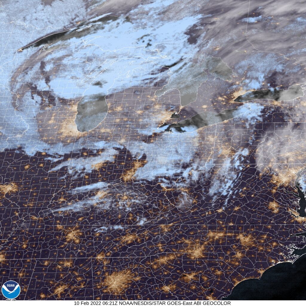
This verification is going to be very interesting. A mixed assortment of precipitation forecasts, as well as questions about the temperature trajectory, especially for Thursday. I’m intrigued. Here is the satellite, with some clouds nosing in from Michigan. This isn’t much, and a more notable system is on it’s way.

Overnight delivery

It sure got cold for the holiday week, didn’t it? All that started with a cold front that arrived over the weekend, and clipped Terre Haute just after midnight on Sunday morning. After nearly a half inch of rain on before midday on Sunday, temperatures peaked in the early afternoon, and dropped precipitously, reaching the mid-30s before Sunday turned to Monday. The forecast was actually pretty solid all the way around, with the top forecast going to the National Weather Service and Forecast.io, but weren’t markedly better than everyone else.
Actuals: Saturday – High 52, Low 31
Sunday – .4 inches of rain, High 51, Low 37

Grade: A-B

Coming Soon…

We have a lot of forecasts on our horizon in the coming days. What kind of action are we looking at?

Cleveland, Tennessee
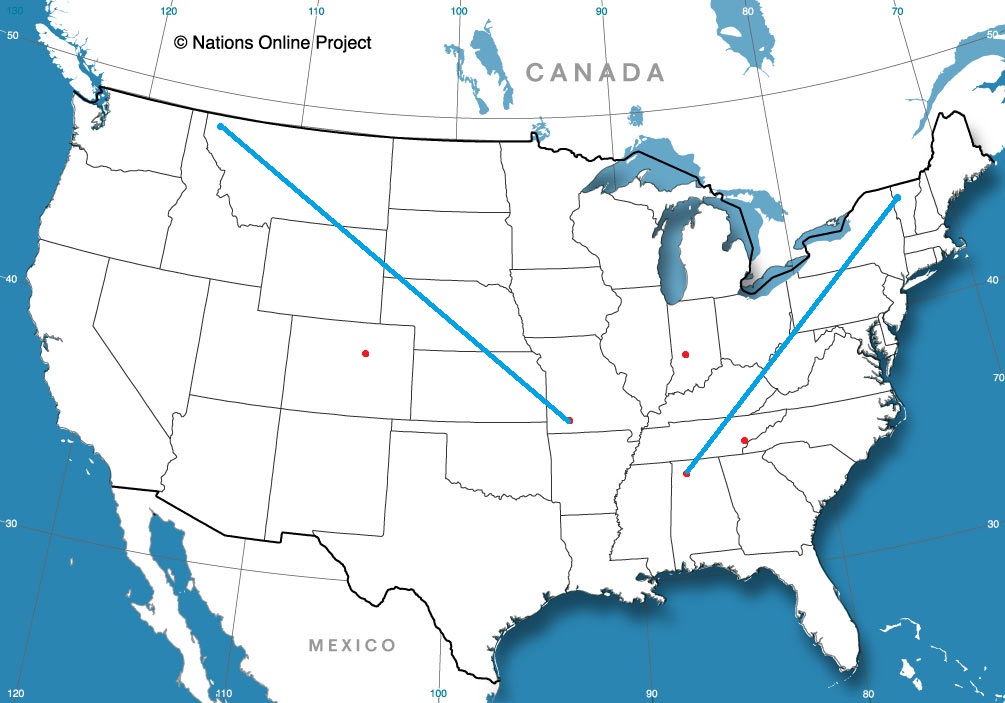
Road Trip from Burlington, Vermont to Cleveland (Road trip line drawn to the wrong city from Burlington. oops!)

Boulder, Colorado

Florence, Alabama

Bloomington, Indiana

Springfield, Missouri
Road Trip from Great Falls, Montana to Springfield

Laredo, Texas

We’re heading down to the banks of the Rio Grande for our forecast this evening. Typically this time of the year, we can expect some high heat and a little bit of humidity. Is that the case today as well?

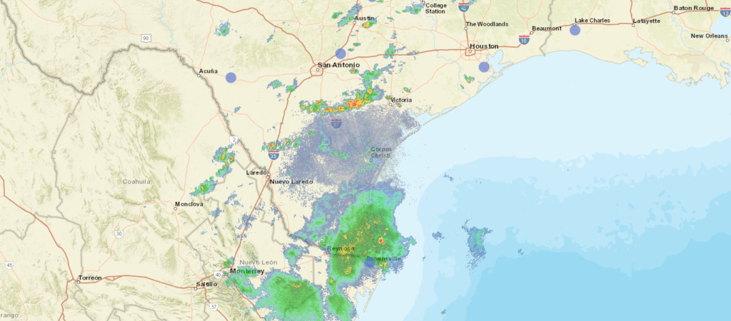
At 656PM, CT, Laredo was reporting a brisk 30mph gust with fair skies and a temperature of 84 degrees. Dew points were near 70, and the moisture rich environment provided an atmosphere that was active with precipitation. A line of thunderstorms ran from north of Victoria to north of Laredo. The storms nearest Laredo on the American side of the border are beginning to diminish, because they are driven less by any synoptic feature, but mostly on the diurnal interaction with onshore flow.
A remnant frontal boundary north of the Gulf Coast is leaching some moisture away from south Texas, but is more importantly allowing the space for high pressure to develop over the western Gulf. Scattered showers and thunderstorms will still be possible in Laredo tomorrow, owing less to the onshore flow, and more to the monsoon flowing through Mexico and north towards the dry line and the Front Range. As high pressure builds, it will interrupt the flow of instability into Laredo, and the end of the week projects to be dry, but much warmer.
Tomorrow – Isolated thunderstorms, High 97, Low 75
Friday – Sunny and hot, High 102, Low 78

TWC: Variable clouds with scattered thunderstorms. High 94, Low 75
Friday – Some clouds in the morning will give way to mainly sunny skies for the afternoon. High 101, Low 78

AW: Tomorrow – Humid with times of clouds and sun High 93, Low 75
Friday – Breezy and less humid with times of sun and clouds High 99, Low 77

NWS: Tomorrow – A 30 percent chance of showers and thunderstorms, mainly after 1pm. Mostly sunny High 96, Low 77
Friday – Sunny and hot, (early AM rain) High 100, Low 78

WB: Tomorrow – Mostly cloudy in the morning then becoming partly cloudy. A 30 percent chance of showers and thunderstorms, High 93, Low 77
Friday – Partly cloudy in the morning, then becoming sunny,, High 100, Low 78

WN: Tomorrow – Partly cloudy with chance of storms, High 95, Low 77
Friday – Mostly sunny, High 100, Low 78

FIO: Tomorrow – Humid and mostly cloudy throughout the day. High 94, Low 75
Friday – Humid and partly cloudy throughout the day. High 98, Low 77

The radar picture below is probably going to be a little less noisy tomorrow, and more so on Friday.

Unclipped

An Alberta Clipper has started tracking for the Upper Midwest, with a burst of snow expected in the western Great Lakes region over the weekend. The feature got it’s start in the middle of the week in, of all places, Alberta. This was key for our forecast site in Billings, which enjoyed the infusion of warm air being drawn north towards the low, and didn’t have to put up with any of the consequences, save for a breezy day on Wednesday. The forecasts were pretty similar, and there was a 4 way tie for third, but Victoria-Weather ended up securing a victory for ourselves.
Actuals: Tuesday – High 39, Low 23
Wednesday – High 50, Low 26

Grade: B-C

Sebastian, Florida

Hey, did anyone watch The Little Mermaid on ABC earlier this week? Why do I ask? Oh, no reason.

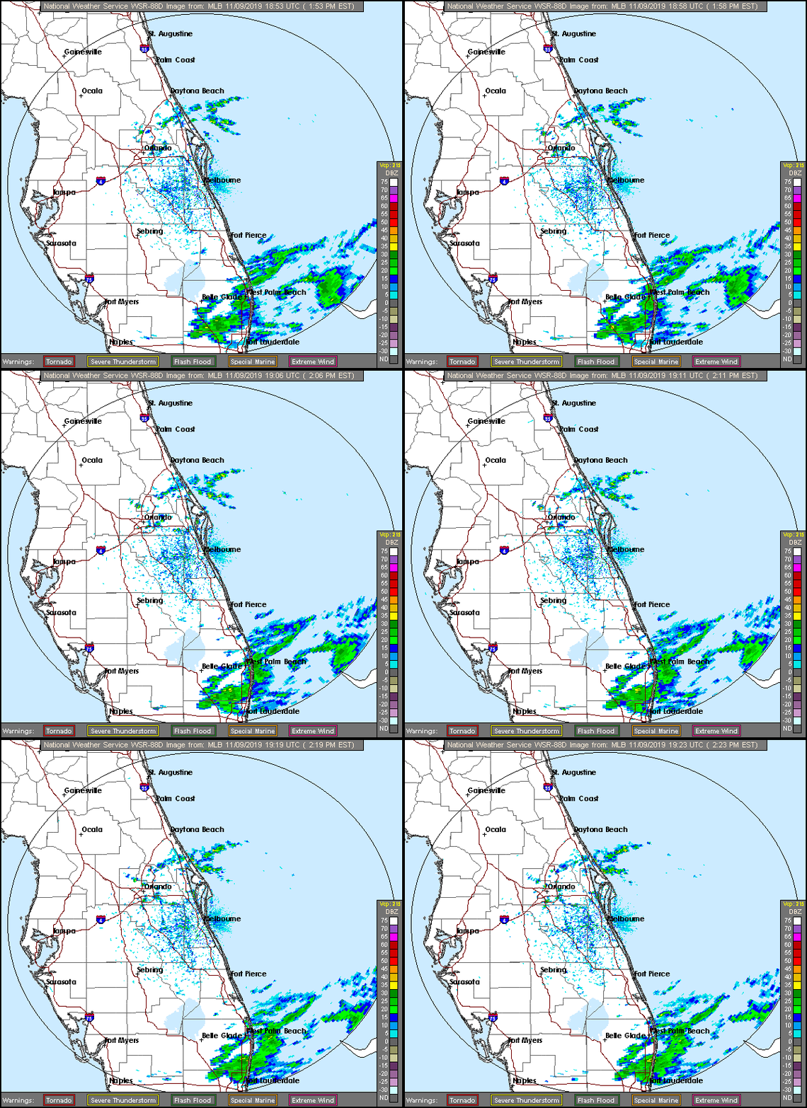
AT 153PM, ET, Sebastian was reporting a temperature of 77 degrees with clear skies. There were showers being seen south of town, from West Palm Beach towards Miami, and a brisk onshore wind carried some light rain near Cape Canaveral, but the air mass moving into the region was the same cool dry one found across the eastern part of the country.
The showers south of town are associated with a fairly strong area of low pressure in the Gulf Stream. An upper level trough lies over the Florida Peninsula, and will drift east out of the area, allowing some humidity and clouds to filter back in, however the skies are likely to stay clear.
Tomorrow – Sunny, High 79, Low 60
Monday – A few clouds, High 82, Low 64

TWC: Tomorrow – Sunshine and clouds mixed. High 79, Low 65
Monday – Intervals of clouds and sunshine. High 82, Low 68

AW: Tomorrow – Partly sunny High 80, Low 68
Monday – A passing shower in the morning; otherwise, partly sunny High 81, Low 70

NWS: Tomorrow – Mostly sunny High 79, Low 65
Monday – Mostly sunny High 81. Low 65

WB: Tomorrow – Partly sunny, High 78, Low 68
Monday – Partly sunny, High 81. Low 69

WN: Tomorrow – Partly cloudy, High 79, Low 65
Monday – Partly cloudy, High 81, Low 65

FIO: Tomorrow – Partly cloudy throughout the day. High 78, Low 68
Monday – Partly cloudy throughout the day. High 81, Low 71

Here is a look at the radar, showing a nice window of dry along the Atlantic Coast of Florida.

Sweltering in the South

We’re deep into the dog days of Summer now, as families are enjoying the last couple of weeks of Summer Vacation before they have to worry about kids going back to school. As expected, conditions are hot and humid across the South, but lately it’s been kicked up a notch above even where locals are accustomed too.

Houston has hit 101 degrees for a third day in a row now, the first time they’ve done that since 2015 when they went 102 102 106 (yikes!). Combined with that has been dew points approaching 80, cranking up the heat index around the metro to 115-120 degrees. Doesn’t look like much relief is on the way either in the coming days.

Pensacola hit 97 yesterday, breaking a high temperature record for the 2nd day in a row. On top of that, potent afternoon thunderstorms then parked overhead dumping over 3.5 inches of rain on the city, also a record for the day. Like Houston, these sweltering conditions are expected to persist for the next couple of days with heat index readings around 110.

Luckily, the residents along the Gulf Coast don’t have to worry about any tropical systems developing over the next several days as the Atlantic Basin is in a pretty quiet pattern right now. However, the intense heat and almost unbearable humidity doesn’t look to relent anytime soon. Stay indoors and cool if you can!

Madison, Wisconsin

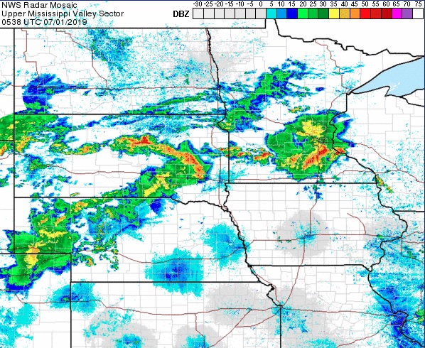
It’s been quite the active day here in the Upper Midwest, with Madison getting a morning line of storms and gusts to 40mph. It’s nothing like the 75mph gusts in Dubuque, not far off to the southwest, but still quite potent in its own right. Let’s take a look at how Wisconsin’s capital city will far as we start off the month of July.

At 853pm CDT, the temperature at Madison, WI was 71 degrees under mostly cloudy skies. A stationary boundary is camping out over the Upper Midwest, parked ahead of a slowly moving cold front through the northern Plains. Storms are expected to fire up over MN along this boundary Sunday evening and ride along it through WI, bringing some possible stormy weather to the area during the Monday morning hours. After this activity clears out, dry weather is expected for the afternoon and evening hours. An area of low pressure looks to shift through the region on Tuesday, bringing about another possible bout of showers and storms. Looks like it’s going to be a noisy start to the month!

Monday: Chance of morning showers/storms. High 87, Low 66.
Tuesday: Isolated afternoon thunderstorm. High 88, Low 71.

TWC: Monday: Afternoon thunderstorms. High 89, Low 69.
Tuesday: Scattered thunderstorms. High 87, Low 71.

AW: Monday: A shower and thunderstorm around. High 88, Low 70.
Tuesday: Strong storms, mainly later. High 85, Low 72.

NWS: Monday: Severe thunderstorms and patchy fog. High 87, Low 68.
Tuesday: Chance of thunderstorms. High 83, Low 72.

WB: Monday: Chance of storms. High 86, Low 71.
Tuesday: Chance of storms. High 85, Low 73.

WN: Monday: Partly cloudy with isolated storms. High 87, Low 68.
Tuesday: Partly cloudy with scattered storms. High 83, Low 72.

FIO: Monday: Rain tonight. High 88, Low 70.
Tuesday: Possible light rain in the evening. High 83, Low 72.

Madison is quiet, for now. However, we see strong storms developing in MN this evening, and it looks like these could slide into southern WI during the morning hours tomorrow.