It’s been quite the active day here in the Upper Midwest, with Madison getting a morning line of storms and gusts to 40mph. It’s nothing like the 75mph gusts in Dubuque, not far off to the southwest, but still quite potent in its own right. Let’s take a look at how Wisconsin’s capital city will far as we start off the month of July.
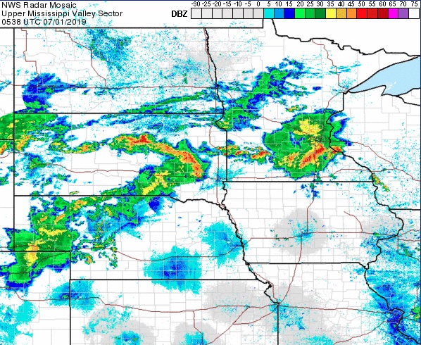
At 853pm CDT, the temperature at Madison, WI was 71 degrees under mostly cloudy skies. A stationary boundary is camping out over the Upper Midwest, parked ahead of a slowly moving cold front through the northern Plains. Storms are expected to fire up over MN along this boundary Sunday evening and ride along it through WI, bringing some possible stormy weather to the area during the Monday morning hours. After this activity clears out, dry weather is expected for the afternoon and evening hours. An area of low pressure looks to shift through the region on Tuesday, bringing about another possible bout of showers and storms. Looks like it’s going to be a noisy start to the month!
Monday: Chance of morning showers/storms. High 87, Low 66.
Tuesday: Isolated afternoon thunderstorm. High 88, Low 71.
TWC: Monday: Afternoon thunderstorms. High 89, Low 69.
Tuesday: Scattered thunderstorms. High 87, Low 71.
AW: Monday: A shower and thunderstorm around. High 88, Low 70.
Tuesday: Strong storms, mainly later. High 85, Low 72.
NWS: Monday: Severe thunderstorms and patchy fog. High 87, Low 68.
Tuesday: Chance of thunderstorms. High 83, Low 72.
WB: Monday: Chance of storms. High 86, Low 71.
Tuesday: Chance of storms. High 85, Low 73.
WN: Monday: Partly cloudy with isolated storms. High 87, Low 68.
Tuesday: Partly cloudy with scattered storms. High 83, Low 72.
FIO: Monday: Rain tonight. High 88, Low 70.
Tuesday: Possible light rain in the evening. High 83, Low 72.
Madison is quiet, for now. However, we see strong storms developing in MN this evening, and it looks like these could slide into southern WI during the morning hours tomorrow.