Joining us today for the forecast is Doug Iverson, the Chief Meteorologist at KPVI in Pocatello, Idaho. Mr. Iverson likes to go by the moniker Doug I. the Weather Guy, and can be found at Twitter @dougiweatherguy. Mr. Iverson is a native to Idaho, and surely has a little extra insight into the weather of Pocatello. Take it away, Doug!
Yay…the weekend is almost here. The Snake River Plain will see less of that wildfire smoke and more of that hot sun.
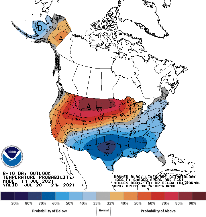
Another massive heat wave is in the forecast according to the CPC’s outlook, and this time, the region expected to be baked is the northern Plains and Upper Midwest. Curiously, while the northern US roasts, the southern part of the country looks to be well below normal. In the summer, that’s comfortable, so it’s not the story,
Unlike the blocking ridge that brought the heat in the Pacific Northwest last month, this looks like a more traditional ridge allowing all that heat to build. Temperatures from Montana through the Dakotas and into northern Minnesota could hit triple digits through early next week.
There will be a remnant mid and upper level trough over the southern US, which will lead to several rainy days, and keep temperatures cool. If it weren’t for that trough, given the greater jet pattern, a more significant heat wave could have been in store for a bigger population.
For whatever reason, we don’t get a lot of trips that are spent entirely out west, like this one. It will last nearly a full, and will cover 481 miles at a pace of 63.2mph, thanks to the lower capacity roads through the desert. Looks like it’s time to get moving.
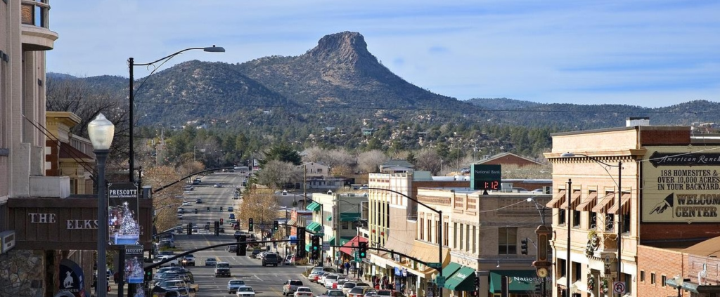
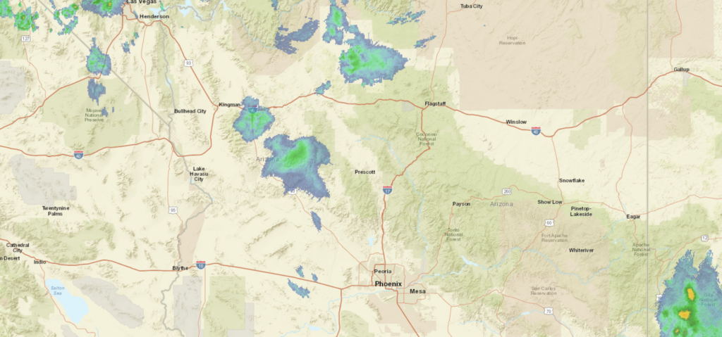
Prescott, Arizona
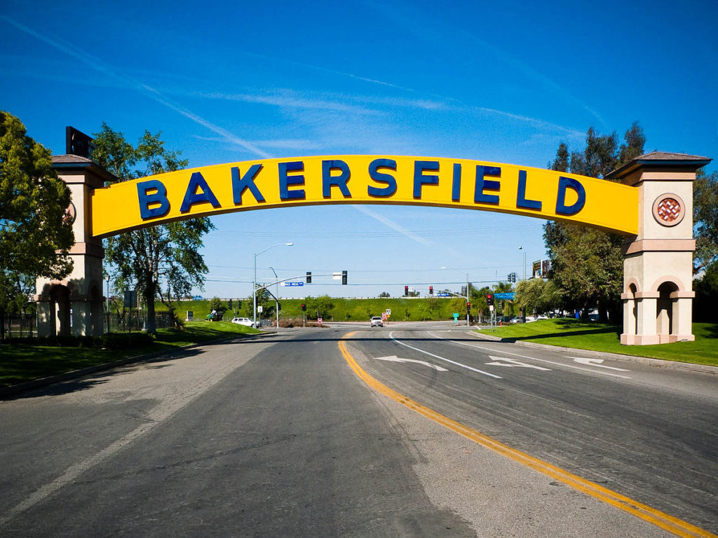
The afternoon monsoon looks to be full and robust tomorrow in the Four Corners region. That means very little for us, however. Prescott will have a slim chance for some afternoon showers and storms, but by that time, we will be deep into the Mohave, hoping our tires don’t melt to the road in the heat. Temperatures will easily reach the triple digits tomorrow in Bakersfield, and you have to imagine it will climb even warmer before we reach town in rural California.
The heat has been extraordinary in the southwest, but Prescott is often in a more favorable weather pattern than their gigantic neighbors to the southeast. How does that translate this time around?
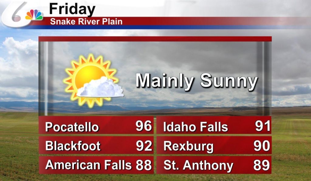
At 753PM, PT, Prescott was reporting a temperature of 80 degrees with clear skies. Some monsoonal rain showers were appearing on radar west of town, and a brisk west wind likely represented outflow, especially given the southeasterly winds of similar magnitude in Kingman. Guidance suggests a stronger ridge tomorrow over the central Rockies, which will stifle the monsoon and lead to a hot dry day in Prescott. Expect some weakening of the ridge and an amplification of the monsoon. Afternoon and evening thunderstorms will be most common in the higher terrain nearer the New Mexico border, but the coverage is expected to increase on Tuesday. Showers and storms are likely to crop up near Prescott, and it’s tough to leave it out of the forecast for Tuesday. Tomorrow – Sunny and hot, High 96, Low 68 Tuesday – Isolated thunderstorms, especially after noon, High 89, Low 68
TWC: Tomorrow – Except for a few afternoon clouds, mainly sunny. A stray shower or thunderstorm is possible High 91, Low 70 Tuesday – Some sun in the morning with increasing clouds during the afternoon. A stray shower or thunderstorm is possible. High 89, Low 69
AW: Tomorrow – Partial sunshine with a thundershower in spots in the afternoon High 92, Low 70 Tuesday – Intervals of clouds and sun with a thunderstorm around in the afternoon High 87, Low 70
NWS: Tomorrow – A 20 percent chance of showers and thunderstorms after 11am. Mostly sunny, High 93, Low 69 Tuesday – A 50 percent chance of showers and thunderstorms. Partly sunny, High 89, Low 69
WB: Tomorrow – Partly cloudy with a 20 percent chance of thunderstorms, High 90, Low 71 Tuesday – Mostly cloudy with a 40 percent chance of thunderstorms, High 85, Low 71
WN: Tomorrow – Partly cloudy with chance of storms High 93, Low 69 Tuesday – Partly cloudy with scattered showers, High 89, Low 69
FIO: Tomorrow – Clear throughout the day. High 93, Low 69 Tuesday – Mostly cloudy throughout the day. High 88, Low 67
I should note that it is 20 degrees cooler in Prescott than it was in Phoenix. Some of it is surely the thunderstorm nearby, seen on radar below.
Hello, and happy weekend! In the dead heat of summer, a road trip across the southern US sounds like the last thing one might want to do, but frankly, most cars have functioning air conditioning, so why not? It will take us a surprisingly swift 4 days at a pace of 70+mph, which is pretty close to our top speed, maybe ever. This will allow us to cover the 2176 miles between the towns in 561 mile chunks (a little less, somehow, on Day 4). Let’s blow the doors off this thing, huh?
DAY ONE (Saturday)
Tallahassee, Florida
Thunderstorms are raging in the Plains tonight, from Colorado and Nebraska southeast through Iowa and Illinois. They will continue to shift to the east southeast through the day. Bad news for the middle of the country but good news for drivers on the Gulf Coast. The showers and storms will be focused along this axis of instability, and will steer clear of the immediate Gulf Coast, leaving only a little bit of spotty activity between Mobile and New Orleans, but not much else. Our day will end on the east side of Lake Charles, still reeling from the last hurricane season. Thankfully, we’ve been quiet so far.
DAY TWO (Sunday) That feature in the middle of the country is going to slow down and wind up over the weekend. A cold front will develop over north Texas and become evident by the evening in the Dallas area, but we aren’t driving through north Texas or Dallas. It will stay Texas hot and Texas dry in the southern part of the state. We’ll get just west of Ozona before we conclude our drive for Sunday.
DAY THREE (Monday) The drive will continue through mostly pleasant conditions on Monday, but the seasonal monsoon is underway out west. The slightly elevated ground along the New Mexico – Arizona border could provide some fertile ground for scattered thunderstorms, and we might see a splash west of Lordstown, New Mexico. They will mostly be wrapped up, but still possible as we slide into Wilcox, east of Tucson.
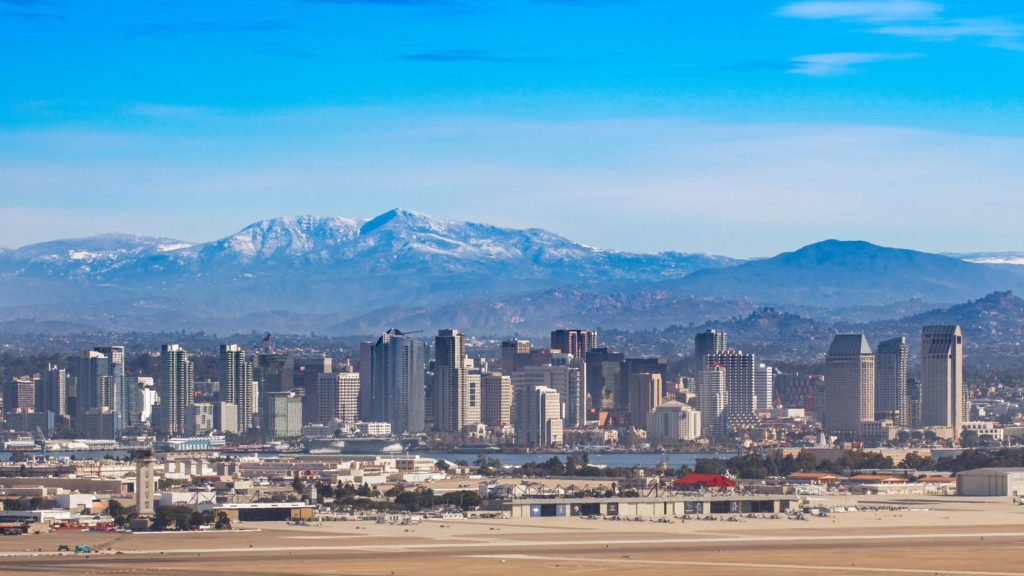
DAY FOUR (Tuesday) A similar pattern is expected for Tuesday. Importantly, this means that showers and storms will wait until late in the day to develop, and will generally be confined to the same spots on Tuesday as they were on Monday. That is to say, they will be most likely in the New Mexico/Arizona border region, which we will long be out of by the time thunderstorms develop. It’s just the hot, dry desert for us through Arizona and inland California, with the pearl at the end of the drive, beautiful San Diego.
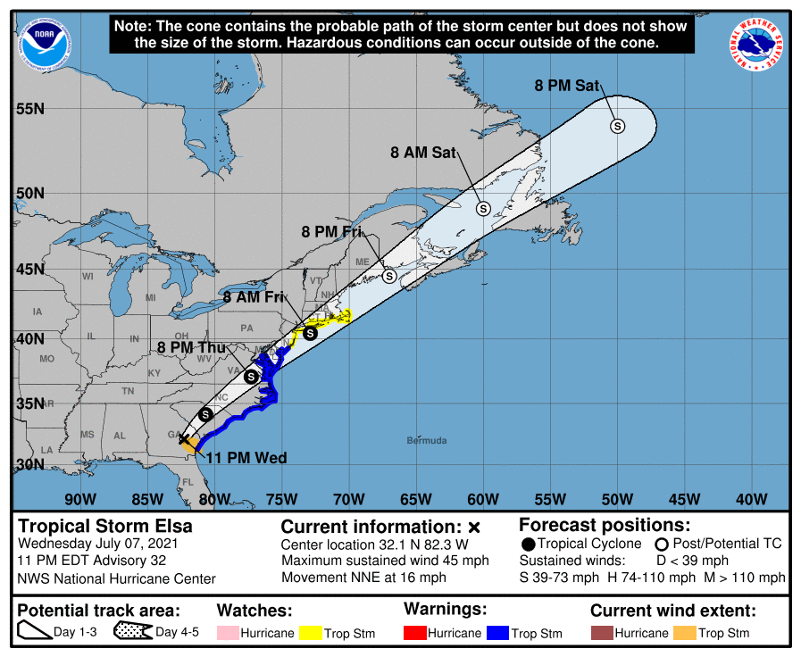
We have already reached the 5th named storm of the tropical season, but Elsa, the former hurricane presently drifting through the southeastern United States is the first hurricane of the season, as well as the strongest storm to make landfall this year.
Elsa’s strongest appearance on land, at least in terms of wind, was last night in Key West, when the airport reported a winds approaching 50mph. The primary threat from Elsa, as with most tropical storms, was, and continues to be, heavy rain.
Flash flood advisories were out for northern Florida and south Georgia, and have now shifted to South Carolina. There were also a few isolated tornado reports, and as Elsa spins northeast, there is a tornado watch for South Carolina and surrounding areas.
Elsa has been a mild storm, so read this as a precautionary tale. It still brought flooding, strong winds and tornadoes inland. Had she taken a different course, there may he been noteworthy storm surge as well, but her path, along the course and inland in a low density part of Florida, was beneficial for local residents. All tropical storms are dangerous, including Elsa, who isn’t quite done yet. Check out the forecast for the next few days.
There is still significant weather coming for the East Coast from Elsa. There are no other areas of concern in the Atlantic, but that will change, and we will then need to continue our maritime vigilance.
It’s been a very hot summer so far out west and in the northern US. The Great Lakes haven’t been spared, but Saginaw did catch a break as June turned to July. There was a little bit of rain on the last day of June, with temperatures in the 80s, and it got even cooler on July 1st, without any rain. That’s outdoors weather! Forecast.io claimed a victory, going dry on the 1st, and getting the best temperature numbers overall. Actuals: Wednesday, June 30th, Rain reported, not measured, High 83, Low 72 Thursday, July 1st, High 73, Low 58
We are now halfway through the year, and have now clearly defined a best forecaster so far this year. After a three way tie through May, Weatherbug had the best month in June, and Victoria-Weather and The Weather Channel did not, giving them the lead as we head into the dog days of summer. Hurricane season and record breaking heat are around the corner, and meteorologists are surely around the corner, so continued forecast vigilance will be necessary.