The weekend forecast for College Station, TX was pretty straightforward: Hot and dry. That’s pretty much how it panned out as well. The only hitch in the forecast’s giddy-up was that the overnight lows were just a smidge higher than some had expected. Oh well, I doubt too many people were complaining about it being 74 instead of 72. Weatherbug narrowly edged out NWS/WN for the victory.
Saturday: High 97, Low 74. Sunday: High 94, Low 74. Forecast Grade: A
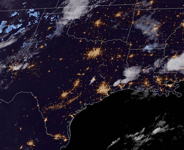
As we head into the first weekend of October, we head into southeast TX to take a look at College Station, home of Texas A&M! Can we expect some football weather or is the south still holding on to a bit of summer?
At 953pm CDT, the temperature at College Station, TX was 83 degrees under fair skies. Normally the people of the city would be gearing up for a big Football Saturday and root their Aggies on, but not this weekend as it’s a bye week for them. Luckily, the fans don’t have to be outside watching them play as it’s shaping up to be a very hot weekend in southeast TX. Weak high pressure continues to linger over the region while the main dome of it is parked well out east. An area of low pressure is shifting through the Central Plains into the Upper Midwest and while it will bring rain and thunderstorms from MN/WI down into KS/OK, it’s going to be pretty quiet on Saturday as just some isolated thunderstorms may pop off towards the LA/TX border. The cold front dropping through the Plains will gain more steam throughout the day on Sunday, bringing showers and storms to AR/OK and northern TX, but by the time the front makes it to the area, it should be during the early Monday morning hours. In the meantime, temperatures look to hit the mid-90s all weekend. A sweltering start to October!
Saturday: Partly cloudy and hot. High 94, Low 72.
Sunday: Partly cloudy, continued hot. High 95, Low 72.
TWC: Saturday: Mostly sunny. High 95, Low 72.
Sunday: Mostly sunny. High 95, Low 73.
AW: Saturday: Mostly sunny. High 95, Low 71.
Sunday: Mostly sunny and hot. High 94, Low 72.
NWS: Saturday: Sunny. High 95, Low 73.
Sunday: Sunny. High 94, Low 72.
WB: Saturday: Mostly sunny. High 94, Low 74.
Sunday: Partly cloudy. High 93, Low 74.
WN: Saturday: Mostly sunny. High 95, Low 72.
Sunday: Mostly sunny. High 94, Low 73.
FIO: Saturday: Humid and partly cloudy throughout the day. High 94, Low 72.
Sunday: Partly cloudy throughout the day. High 94, Low 71.
It’s a quiet night for the most part around southeast TX tonight, some storms are lingering east of Houston. A fairly quiet couple of days are in store so enjoy this hot weekend!
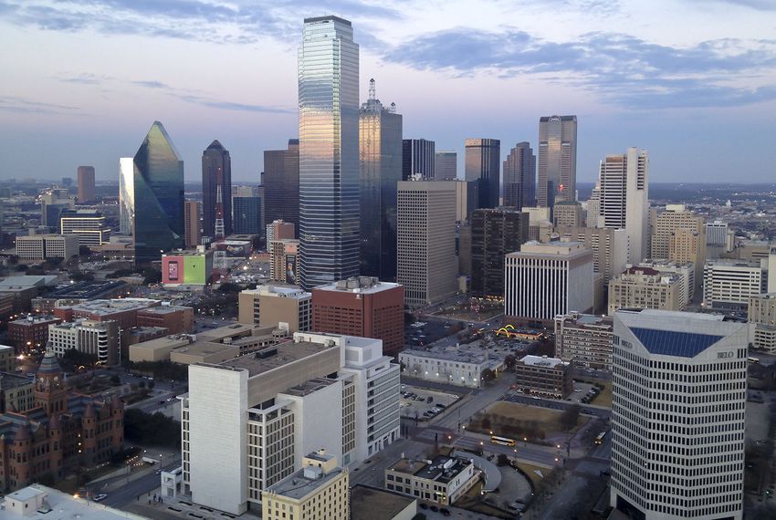
Tonight we embark on a 1,500 mile trip, from the Pacific Coast to the Big D. What weather will this weekend road trip encounter?? Let’s find out!
DAY ONE
As an upper-level trough shifts through the Pacific NW, an area of low pressure at the surface is developing over western WY and trailing a cold front of sorts back through the Great Basin. Luckily for us, all this activity is going to stay to the north of our Day One travels as we head east out of Oxnard through the northern LA Basin and then eastward on I-10 past Palm Springs and through the desert, eventually ending the day in Phoenix.
DAY TWO
It’s going to be a full day heading east on I-10, and better have those sunglasses because it’s looking like a pretty good day for traveling! There’s a slight chance of a few evening isolated thunderstorms, but those are just expected around the Big Bend area of the TX/Mexico border and should be off to the south of where we end our day in Van Horn, TX.
DAY THREE
I-20 is gonna be our home for the final leg of this stretch. It should be a pretty quiet day as we pass be Odessa, Midland, and Abilene. As we approach our final destination, there could be some widely scattered showers and thunderstorms as the tail end of a cold front shifts through the Red River Valley. Most activity should be off to the north over OK though, so odds are it’ll be a dry evening as we pull into Dallas!
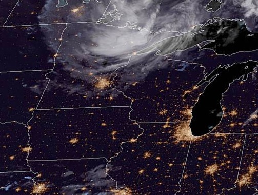
As we head into midweek and draw ever closer to the end of Meteorological Summer, let’s head to central IL and see what’s in store for Peoria!
At 1154pm CDT, the temperature at Peoria, IL was 64 degrees under fair skies. A large dome of high pressure is found over the region, making for very pleasant conditions as we head into midweek. This area of low pressure is going to shift off to the south and east during the day, however, as a cold front pushes through the Upper Midwest. While the main impacts of the front look to be off to the north and east, the tail end of the front looks to move through during the evening hours, which could bring some scattered showers and an isolated thunderstorm to the area. No washouts are expected from it, but don’t be surprised if you have to dodge a dinnertime shower.
Wednesday: Sunny and pleasant. High 79, Low 57. Thursday: Mostly sunny, isolated evening shower. High 86, Low 60.
TWC: Wednesday: Sunny. High 80, Low 58. Thursday: Afternoon thunderstorms. High 88, Low 56.
AW: Wednesday: Mostly sunny; pleasant. High 78, Low 56. Thursday: Sunshine; pleasant. High 84, Low 56.
NWS: Wednesday: Sunny. High 77, Low 56. Thursday: Sunny. High 85, Low 56.
WB: Wednesday: Sunny. High 78, Low 57. Thursday: Sunny. High 84, Low 57.
WN: Wednesday: Sunny. High 77, Low 56. Thursday: Mostly sunny. High 85, Low 56.
FIO: Wednesday: Clear throughout the day. High 77, Low 54. Thursday: Possible light rain in the evening. High 84, Low 54.
We see the swirl of clouds associated with an area of low pressure over northern MN, but central IL is pretty quiet tonight. That seems to be the story for the next couple days as well.
As we head into the weekend, let’s take a trip to the Gulf Coast and see how the weather is shaping up for Beaumont, TX. Will it be sunny beach weather or will be be scampering for cover?
At 853pm CDT, the temperature at Beaumont, TX was 83 degrees under partly cloudy skies. A frontal boundary looks to sag southward into portions of the Deep South over the next couple of days, but won’t make it anywhere near the Gulf Coast. A typical summertime pattern looks to be in place, with plenty of heat and low-level moisture fueling afternoon thunderstorms in the area. Friday looks to have the better chance of the 2 days in seeing thunderstorms, but Saturday will certainly see it’s share of activity in the vicinity. It doesn’t look like the days will be a washout, but if you’re going out and about, make sure you don’t leave the car windows open.
Friday: Cloudy, scattered storms. High 88, Low 77. Saturday: Mostly cloudy, continued storm activity. High 88, Low 76.
TWC: Friday: Scattered thunderstorms. High 86, Low 75. Saturday: Scattered thunderstorms. High 87, Low 75.
AW: Friday: Showers and a heavier tstm. High 84, Low 76. Saturday: A shower or heavy tstm. High 88, Low 75.
NWS: Friday: Thunderstorms expected. High 87, Low 76. Saturday: Thunderstorms likely. High 89, Low 75.
WB: Friday: Thunderstorms. High 83, Low 77. Saturday: Chance of thunderstorms. High 85, Low 76.
WN: Friday: Mostly cloudy with light showers. High 87, Low 76. Saturday: Partly cloudy with thunderstorms likely. High 89, Low 75.
FIO: Friday: Rain starting in morning, continues into evening. High 85, Low 78. Saturday: Possible light rain starting in morning. High 87, Low 77.
Scattered shower and thunderstorms have shifted out over the Gulf of Mexico tonight. However, additional thunderstorms are expected to develop during the afternoon hours the next couple of days.
Utica got the slightest bit of rain Monday morning as dissipating activity gave the city just enough to nudge the rain gauge. The rest of the day and Tuesday was fairly pleasant, though the morning lows were a smidge lower than most expected. Us here at VW anticipated that, however, and rode those cooler morning lows to an easy victory.
Monday: 0.01″ in a morning shower. High 82, Low 64.
Tuesday: High 82, Low 57.
Forecast Grade: A
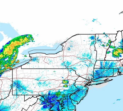
Today we’re heading to Central NY and taking a closer look at Utica, NY to start the workweek.
At 1153pm EDT, the temperature at Utica, NY (officially nearby Griffiss AFB) was 68 degrees with a few clouds. The tail end of a cold front is shifting its way through the Northeast, and with it showers and thunderstorms are moving through the Great Lakes. While thunderstorm activity should be winding down by the time activity moves through, there could still be a cell or two that affects the region. Otherwise, general rain showers are anticipated before conditions clear out for the afternoon. High pressure shifts in for Tuesday and brings with it sunnier skies and pleasant conditions!
Monday: Morning rain/possible storm, clearing late. High 83, Low 65.
Tuesday: Mostly sunny. High 81, Low 57.
TWC: Monday: Scattered thunderstorms. High 83, Low 67.
Tuesday: Mostly sunny. High 84, Low 59.
AW: Monday: A shower or tstorm in spots. High 84, Low 68.
Tuesday: Mostly sunny; less humid. High 83, Low 62.
NWS: Monday: Showers then slight chance of storms. High 85, Low 66.
Tuesday: Mostly sunny then slight chance of showers. High 83, Low 61.
WB: Monday: Chance of thunderstorms. High 81, Low 69.
Tuesday: Partly sunny. High 81, Low 59.
WN: Monday: Partly cloudy with light showers. High 86, Low 67.
Tuesday: Partly cloudy with isolated showers. High 85, Low 63.
FIO: Monday: Morning rain then partly cloudy. High 83, Low 67.
Tuesday: Partly cloudy throughout the day. high 85, Low 60.
The Utica area is quiet currently, but storms off to the west will be approaching through the morning hours.
The forecast for Birmingham was a fairly straightforward one, dry and HOT. Which is was, no doubt about that. The morning lows were a couple degrees cooler than most had anticipated however, which lead to some higher than average scores given the comparatively benign pattern. NWS and WeatherNation split top billing.
Friday: High 98, Low 67.
Saturday: High 100, Low 67.
Forecast Grade: B
Today we embark on a 2-day, 677-mile trek through the Appalachians to the Deep South. We could probably get this one in one very long day, but we’re gonna take our time and enjoy some scenery!
DAY ONE
High pressure is found over the OH and TN Valleys, keeping much of the region dry into the Central and Southern Appalachians. A sunny day is expected as we head south out of Morgantown through WV and through western Virginia. Continued pleasant but hot conditions are anticipated for the rest of the day as we end this leg in Knoxville.
DAY TWO
As high pressure continues to control the region, more sunny skies and dry conditions are expected for the rest of the trip. Temperatures are expected to hit the triple digits as we head past Chattanooga into Alabama and eventually into Birmingham, but at least the trip will be dry!
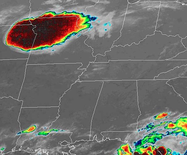
As we look forward to the weekend, let’s head to the Deep South and see how the historic city of Birmingham will fare!
At 953pm CDT, the temperature at Birmingham, AL was 80 degrees under fair skies. It’s been nothing short of ridiculously hot over the Southeast this past week as I mentioned a few days ago, and it doesn’t look like it’s gonna go anywhere soon. A strong ridge of high pressure is continuing to sit over the Deep South and will park itself there for another couple of days yet. It will break down a bit on Sunday and a chance of thunderstorms will re-enter the forecast. But until then, it’ll be dry but scorching hot!
Friday: Sunny and hot. High 95, Low 71.
Saturday: Sunny and even hotter. High 96, Low 69.
TWC: Friday: Sunny. High 96, Low 70.
Saturday: Sunny. High 98, Low 70.
AW: Friday: Mostly sunny. High 96, Low 70.
Saturday: Mostly sunny; hot. High 98, Low 68.
NWS: Friday: Sunny. High 98, Low 70.
Saturday: Hot. High 100, Low 71.
WB: Friday: Sunny. High 95, Low 71.
Saturday: Sunny. High 97, Low 70.
WN: Friday: Sunny. High 98, Low 70.
Saturday: Mostly sunny. High 100, Low 71.
FIO: Friday: Clear throughout the day. High 95, Low 70.
Saturday: Clear throughout the day. High 97, Low 69.
The Deep South is extremely quiet tonight, and looks to remain that way as we head into the weekend. Just don’t look at that cluster of severe thunderstorms in MO/NE. Nothing to see here folks!