Morgantown, West Virginia

As we head into the latter part of the workweek, lets head off to Appalachia and see what Morgantown is up to the next couple of days!

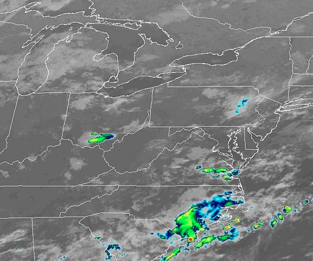
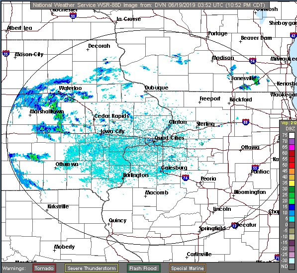
At 1153pm EDT, the temperature at Morgantown, WV was 70 degrees under fair skies. A weak area of low pressure is traversing the OH Valley region and looks to be the instigator of some afternoon thunderstorm activity. Nothing particularly severe is anticipated, just some good ol’ fashioned summertime thunderstorms. Activity should dwindle down late evening as the system pushes off to the east. Friday looks to be on the dry side with perhaps some isolated shower activity staying up in the mountains to the east.

Thursday: Increasing clouds in afternoon, scattered thunderstorms possible. High 84, Low 64.
Friday: Decreasing clouds in afternoon. High 84, Low 66.

TWC: Thursday: Afternoon thunderstorms. High 85, Low 64.
Friday: Partly cloudy. High 84, Low 64.

AW: Thursday: A strong afternoon thunderstorm. High 85, Low 66.
Friday: Periods of sun. High 86, Low 67.

NWS: Thursday: Scattered afternoon showers and thunderstorms. High 86, Low 65.
Friday: Isolated early morning shower, otherwise mostly sunny. High 87, Low 65.

WB: Thursday: Chance of thunderstorms. High 83, Low 64.
Friday: Partly cloudy. High 84, Low 65.

WN: Thursday: Partly cloudy with scattered showers. High 86, Low 65.
Friday: Partly cloudy. High 87, Low 65.

FIO: Thursday: Partly cloudy, few showers. High 86, Low 62.
Friday: Partly cloudy throughout the day. High 87, Low 66.

Quiet conditions are found around Morgantown this evening, with some shower activity found over southern OH. We can expected some more activity tomorrow but then taper down for the weekend.

Tallahassee, Florida to Grand Forks, North Dakota

Today we embark on a 3-day, 1,687-mile cross-country trip. However, we’re not going coast to coast, we’re going from the Gulf to the Great Plains! Let’s see what the next few days has in store for us as we make our way from Tallahassee to Grand Forks.

DAY ONE

Quiet conditions are expected for our departure from Tallahassee in the morning. As we pass by Montgomery midday, a few isolated showers and thunderstorms look to develop in the region, but most of that should be off to the east of the route. Dry weather should persist for the rest of the day as we pull into Nashville for the night

DAY TWO

Quiet conditions are anticipated for the start of the second day, though as we head northwestward on I-24 into KY, there could be a couple isolated showers during the late morning hours. We’ll pass by Paducah and head north towards Champaign, with partly to mostly cloudy skies along the route. Dry weather persists throughout the day as we pass Champaign and continue north towards Rockford, our stop for the night. There could be some isolated shower activity as we pull in, but thunderstorms might be seen off to the northwest.

DAY THREE

Low pressure shifting through WI and IL to start the day could make for a cloudy and showery morning as we head north towards Madison. Thunderstorm activity, if it’s already started, should be off to the east so that’s some good fortune for us as we start this long day. Dry conditions are expected through the midday and afternoon hours along I-94 through WI towards the Twin Cities, though don’t be surprised if a late-afternoon shower pops up as we make our way into MN. As we continue along I-94 past St. Cloud towards Fargo, dry conditions are expected once again and remain so for the rest of the trip into Grand Forks!

Sweltering in the South

We’re deep into the dog days of Summer now, as families are enjoying the last couple of weeks of Summer Vacation before they have to worry about kids going back to school. As expected, conditions are hot and humid across the South, but lately it’s been kicked up a notch above even where locals are accustomed too.

Houston has hit 101 degrees for a third day in a row now, the first time they’ve done that since 2015 when they went 102 102 106 (yikes!). Combined with that has been dew points approaching 80, cranking up the heat index around the metro to 115-120 degrees. Doesn’t look like much relief is on the way either in the coming days.

Pensacola hit 97 yesterday, breaking a high temperature record for the 2nd day in a row. On top of that, potent afternoon thunderstorms then parked overhead dumping over 3.5 inches of rain on the city, also a record for the day. Like Houston, these sweltering conditions are expected to persist for the next couple of days with heat index readings around 110.

Luckily, the residents along the Gulf Coast don’t have to worry about any tropical systems developing over the next several days as the Atlantic Basin is in a pretty quiet pattern right now. However, the intense heat and almost unbearable humidity doesn’t look to relent anytime soon. Stay indoors and cool if you can!

Madison, Wisconsin

It’s been quite the active day here in the Upper Midwest, with Madison getting a morning line of storms and gusts to 40mph. It’s nothing like the 75mph gusts in Dubuque, not far off to the southwest, but still quite potent in its own right. Let’s take a look at how Wisconsin’s capital city will far as we start off the month of July.

At 853pm CDT, the temperature at Madison, WI was 71 degrees under mostly cloudy skies. A stationary boundary is camping out over the Upper Midwest, parked ahead of a slowly moving cold front through the northern Plains. Storms are expected to fire up over MN along this boundary Sunday evening and ride along it through WI, bringing some possible stormy weather to the area during the Monday morning hours. After this activity clears out, dry weather is expected for the afternoon and evening hours. An area of low pressure looks to shift through the region on Tuesday, bringing about another possible bout of showers and storms. Looks like it’s going to be a noisy start to the month!

Monday: Chance of morning showers/storms. High 87, Low 66.
Tuesday: Isolated afternoon thunderstorm. High 88, Low 71.

TWC: Monday: Afternoon thunderstorms. High 89, Low 69.
Tuesday: Scattered thunderstorms. High 87, Low 71.

AW: Monday: A shower and thunderstorm around. High 88, Low 70.
Tuesday: Strong storms, mainly later. High 85, Low 72.

NWS: Monday: Severe thunderstorms and patchy fog. High 87, Low 68.
Tuesday: Chance of thunderstorms. High 83, Low 72.

WB: Monday: Chance of storms. High 86, Low 71.
Tuesday: Chance of storms. High 85, Low 73.

WN: Monday: Partly cloudy with isolated storms. High 87, Low 68.
Tuesday: Partly cloudy with scattered storms. High 83, Low 72.

FIO: Monday: Rain tonight. High 88, Low 70.
Tuesday: Possible light rain in the evening. High 83, Low 72.

Madison is quiet, for now. However, we see strong storms developing in MN this evening, and it looks like these could slide into southern WI during the morning hours tomorrow.

Casper, Wyoming

As temperatures are expected to soar here in the Upper Midwest this weekend, let’s venture to the Rockies and take a peek at how things will pan out in Central Wyoming!

At 1120pm MDT, the temperature at Casper, WY was 61 degrees under fair skies. Low pressure found over the Northern High Plains will shift its way into Central Canada throughout the day Saturday, trailing a boundary back into the Great Basin. Luckily for Casper, the main focus of any precip will be over the Dakotas as hot, humid air streams northward into the Northern Plains/Upper Midwest, kicking up storms off to the east. Low pressure that develops over the Great Basin Saturday shifts into the Central Rockies on Sunday. This increased cloud clover will bring much lower temps during the day, and as the overall boundary sags a bit southward, chances for showers and isolated thunderstorms Sunday evening increases.

Saturday: Mostly sunny. High 92, Low 57.
Sunday: Increasing clouds and cooler. Possible evening thunderstorms. High 81, Low 54.

TWC: Saturday: Mostly sunny. High 93, Low 55.
Sunday: Cloudy, isolated showers. High 80, Low 54.

AW: Saturday: Partly sunny; hot. High 91, Low 55.
Sunday: Mainly cloudy; not as warm. High 80, Low 52.

NWS: Saturday: Sunny then mostly sunny and breezy. High 91, Low 53.
Sunday: Mostly cloudy then chance of thunderstorms. High 85, Low 59.

WB: Saturday: Mostly sunny. High 89, Low 58.
Sunday: Chance of thunderstorms. High 77, Low 53.

WN: Saturday: Mostly sunny. High 91, Low 53.
Sunday: Mostly cloudy with scattered storms. High 85, Low 59.

FIO: Saturday: Foggy, then partly cloudy. High 93, Low 63.
Sunday: Mostly cloudy throughout the day, isolated showers. High 83, Low 58.

We see a fairly quiet pattern over Wyoming, while a thunderstorm complex is keeping things interesting along the Canadian border.

Dubuque, Iowa

As we close in on the official start of Summer later this week, let’s take a look at how the Upper Midwest will fare over the next couple of days.

At 953pm CDT, the temperature at Dubuque, IA was 68 degrees under mostly cloudy skies. A weak boundary continues to linger from Michigan through IA back into the Central Plains. It’s the focus of scattered shower and isolated thunderstorm activity and looks to remain so for tomorrow. There’s a chance of scattered shower activity during the daytime hours as it shifts away from the Dubuque area, while thunderstorm activity should remain off to the south. Thursday should be on the dry side as the aforementioned boundary shifts away and in advance of another low pressure system shifting into the Dakotas. There might be some shower activity on Friday, but not Thursday!

Wednesday: Scattered showers possible. High 71, Low 61.
Thursday: Mostly cloudy and warmer. High 75, Low 56.

TWC: Wednesday: Morning showers. High 75, Low 63.
Thursday: Partly cloudy. High 77, Low 56.

AW: Wednesday: Cloudy, a touch of rain. High 72, Low 62.
Thursday: Mostly cloudy; comfortable. High 75, Low 56.

NWS: Wednesday: Chance of showers. High 74, Low 62.
Thursday: Mostly sunny. High 76, Low 57.

WB: Wednesday: Chance of storms. High 71, Low 63.
Thursday: Mostly sunny. High 74, Low 57.

WN: Wednesday: Mostly cloudy with scattered showers. High 74, Low 62.
Thursday: Partly cloudy. High 76, Low 57.

FIO: Wednesday: Light rain until afternoon. High 73, Low 64.
Thursday: Partly cloudy throughout the day. High 77, Low 59.

There’s some light rain shower activity off to the west. We’ll see another day of this smattering of activity before things clear out.

Hot Here, Hot There, Hot Everywhere!

We’re now into Meteorological Summer (June-August), so it’s no surprise that temperatures are starting to heat on up here across the country. After what seemed like an extremely late start to Spring around here in the Upper Midwest, everything is in full bloom as the temperatures have been pushing into the 70s and 80s lately. Well, today here in the Twin Cities, we officially hit 90! We last hit 90 on September 16th, a span of 264 days! (The record, if you wish to know, is an insane 691 days, Minneapolis went all of 1915 without hitting 90F). Luckily the humidity was kept in check today, with dew points around 60, so it was nowhere close as bad as it could have been.

Where it WAS pretty awful was south Texas. Brownsville hit 104 degrees today, not only setting a record for the date, but setting an all-time record high for the month of June! (103F in 1918 and 2012 previously). However, that was no match for Falcon Lake, TX (also along the Texas/Mexico border), which reached an incinerating 116 degrees! Heat Indicies reached into the 120s in some places given the dew points were in the upper 70s to 80 at some spots. Certainly no good for anybody having to be outside in that.

And it’s not just the US that’s roasting right now. Record heat engulfed Scandinavia, as portions of northern Finland reached well into the 80s, nearly into the Arctic Circle. Some reports are saying they haven’t experienced this type of heat that far north so early in the summer season before. And since most of those locations have homes which aren’t equipped with air conditioning, it’s leading to some miserable nights.

Most likely we’ll see more extreme heat “outbreaks” as Summer plugs along, but we can always hope that they’re short in duration and people take precautions to protect themselves from its effects.

Redding, California to Montgomery, Alabama

Got a long trip from northern CA to the Deep South, covering 2,536 miles, which should take 5 days to cover.

DAY ONE

A broad ridge of high pressure is found over the Great Basin/Four Corners region, which is keeping most of the thunderstorm activity over the Sierras as well as the Rockies in the Four Corners region. Much of the day should be dry and fairly quiet as we travel southward from Redding along I-5 to Sacramento, then along Hwy 99 through much of the Central Valley past Fresno and Bakersfield. Late in the afternoon and evening we’ll cut across the Antelope Valley on 58 before ending our long day in Barstow.

DAY TWO

Going to be spending all day on I-40 as we head east out of Barstow and eventually make our way into northwestern AZ by midday. Some spotty thunderstorms are expected to get going over the mountains as we make our way towards Flagstaff, so by the evening hours some of this activity looks to roll off of them, which could give us a bit of a wet welcome heading past Winslow and Holbrook before ending our night in Gallup, NM.

DAY THREE

Slightly shorter day today, but still a hike across New Mexico as we continue our tour of I-40. However, storms are expected to flare up over the mountains in the central part of the state, so if we don’t get past them in time, we’ll be needing to turn on our wipers as we pass Albuquerque and eventually Santa Rosa. If we can get out ahead of the storms, it should be smooth sailing into Amarillo, TX, where we’ll end the night. Don’t be surprised if some late evening storms roll into town however, might keep us up a bit.

DAY FOUR

Our tour of I-40 comes to an end as we head southeast on 280 out of Amarillo towards Wichita Falls. Unfortunately a boundary settling across the Central Plains eastward is interacting with moisture coming up from the Gulf, and widespread showers and thunderstorms are expected to develop during the midday hours and persist well into the evening. Some thunderstorm activity could get potent as we pass by the Dallas-Fort Worth area, hopefully we’re able to dodge it as we continue onwards and end the long day in Shreveport, LA.

DAY FIVE

Looks like it will be another day of dodging showers and storms as low pressure shifts into the Mid-MS River Valley, increasing the chances of storms from AR/LA eastward into AL/GA as the day progresses. I don’t expect a washout, but you will have to keep an eye on the sky as we push through MS on I-20 past Jackson and eventually into Alabama before finally ending our trip in Montgomery.

Montgomery, Alabama

Tonight let’s take a trip down south and see how the rest of the weekend shapes up for the lovely folks in Montgomery, AL!

At 953pm CDT, the temperature in Montgomery, AL was 74 degrees under fair skies. The tail end of a boundary is working through the TN Valley this evening, but behind it high pressure is moving in. This area of high pressure is going to keep the Montgomery area dry over the next couple of days, with just a few passing afternoon clouds anticipated. Looks like a good start to the month!

Sunday: Sunny. High 93, Low 66.
Monday: Few afternoon clouds. High 92, Low 68.

TWC: Sunday: Mostly sunny. High 94, Low 65.
Monday: Partly cloudy. High 93, Low 68.

AW: Sunday: Mostly sunny; warm. High 90, Low 64.
Monday: Mostly sunny; warm. High 89, Low 68.

NWS: Sunday: Sunny. High 93, Low 68.
Monday: Sunny. High 91, Low 70.

WB: Sunday: Sunny. High 92, Low 66.
Monday: Mostly sunny. High 91, Low 69.

WN: Sunday: Mostly sunny. High 93, Low 68.
Monday: Mostly sunny. High 91, Low 70.

FIO: Sunday: Clear throughout the day. High 93, Low 66.
Monday: Partly cloudy until evening. High 92, Low 70.

Here we see a fairly calm and clear night over the Deep South, with much of the same expected over the next couple of days.

Parkersburg, WV to Sandusky, OH

Today we embark on a quick little road trip, just 229 miles separate these 2 cities, and it’ll take barely longer than 1 viewing of Avengers: Endgame to get there. Don’t even need to pack snacks for this trip (but we will anyways)

As a frontal boundary sits over southern Michigan and slowly sags southward during the day, some scattered rain shower activity is expected over northern OH throughout the day. It’ll be a dry start to the trip travelling north from Parkersburg, but the closer we get to the lakefront, the more likely we’ll see a scattered shower or two across our route. Nothing particularly heavy is expected, just the weather being a little annoying.