Sandusky, Ohio

As we start off the workweek, let’s travel to the shores of Lake Erie and see what Sandusky is up to!

At 1153pm EDT, the temperature at Sandusky, OH was 60 degrees under fair skies. There’s a very slow moving frontal boundary over southern Michigan and looks to sag slightly south over northern Ohio tomorrow, giving the Sandusky area a chance of shower activity. It will remain overcast throughout the day and well into Wednesday as well, despite the boundary lifting back north a bit. An area of low pressure will be intensifying during the day Wednesday as it approaches the region, but the best chance of showers with this system will be early Wednesday as the front lifts well north during the afternoon/evening and it won’t be until early Thursday morning until more significant showers/storms enter the area. Until then, it will be a murky and cool couple of days.

Tuesday: Isolated midday showers. High 59, Low 46.
Wednesday: Mostly cloudy, scattered showers. High 57, Low 45.

TWC: Tuesday: Cloudy, isolated showers. High 56, Low 47.
Wednesday: Morning showers, windy. High 52, Low 46.

AW: Tuesday: Occasional rain and drizzle. High 57, Low 48.
Wednesday: A shower and thunderstorm around. High 52, Low 45.

NWS: Tuesday: Slight chance of showers/storms. High 58, Low 48.
Wednesday: Chance of showers then storms. High 54, Low 45.

WB: Tuesday: Mostly cloudy, chance of showers. High 58, Low 45.
Wednesday: Chance of storms. High 51, Low 45.

WN: Tuesday: Mostly cloudy with isolated showers. High 56, Low 45.
Wednesday: Mostly cloudy with scattered showers. High 54, Low 45.

FIO: Tuesday: Foggy overnight. High 60, Low 49.
Wednesday: Mostly cloudy thru day, breezy in afternoon. High 55, Low 46.

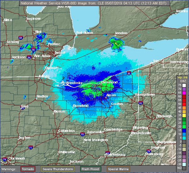
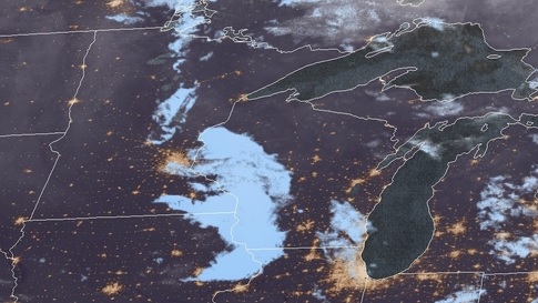
There’s a few light showers off to the northwest in Michigan, we’ll see these spotty showers a bit closer to home over the next couple of days.

Anniston, Alabama

Today we head down south to see what’s in store for the weekend in Annison, AL! This weekend marks the 8th anniversary of the 2011 Super Outbreak, will they have a quiet weekend to reflect, or will they have to keep their eyes on the sky once again?

At 1053pm CDT, the temperature at Anniston, AL was 54 degrees under fair skies. High pressure is sitting over the Deep South, and should keep an area of low pressure off to the north (which will bring snow to MN/WI/IL) so beautiful weather is in store for Saturday! The tail end of the cold front associated with the aforementioned low pressure system sags into the Deep South for Sunday. While mostly cloudy skies are expected for much of the day, only a couple of isolated showers will push far enough south to threaten the Anniston area. If anything does impact the area, it should be short lived. Overall, a very nice weekend is in store, scores better than that fateful day in 2011.

Saturday: Sunny and beautiful. High 79, Low 46.
Sunday: An isolated afternoon shower possible. High 78, Low 53.

TWC: Saturday: Mostly sunny. High 78, Low 45.
Sunday: Isolated thunderstorms. High 78, Low 56.

AW: Saturday: Plenty of sun; beautiful. High 77, Low 43.
Sunday: A passing morning shower. high 78, Low 55.

NWS: Saturday: Sunny. High 78, Low 48.
Sunday: Slight chance of afternoon thunderstorms. High 80, Low 56.

WB: Saturday: Sunny. High 77, Low 45.
Sunday: Partly cloudy. High 77, Low 56.

WN: Saturday: Sunny. High 78, Low 48.
Sunday: Partly cloudy with isolated storms. High 80, Low 56.

FIO: Saturday: Partly cloudy starting in the evening. High 78, Low 47.
Sunday: Partly cloudy until night. High 77, Low 57.

It’s a fairly clear night across the region, and looks to be that way for much of the weekend!

Syracuse, New York to Tucson, Arizona

Today we embark on a 5-day, cross-country road trip that’ll cover 2,337 miles. That’s a lot of snacks we need to stock up on! Let’s get a move-on, not a moment to waste!

DAY ONE

An area of low pressure is shifting through far southern Quebec/New England, with a cold front trailing through NY/PA back to the OH Valley. There might be an isolated rain shower lingering in the Syracuse area at dawn, but most of this activity should be off to the northeast of the city as we depart on our westward journey. The day should be dry but cloudy to start, then clouds clear out as we pass Buffalo and follow the shores of Lake Erie to Cleveland. From there we turn southward and end our rather uneventful start to the trip in Columbus.

DAY TWO

An area of low pressure looks to shift into the OH Valley to start the day, bringing some rain shower activity to the Columbus area as we head westward. Conditions improve a bit as we make it to Indianapolis, but a second round of showers is possible as we move through IL towards St. Louis as the tail end of a cold front works in from the north. Heavier stuff should remain off to the south as another area of low pressure lifts northeastward from the Lower MS River Valley, but keep an eye out on some shower activity as we pass St. Louis and finish the day in Rolla, MO.

DAY THREE

A fairly quiet day is expected today as our leg is between systems. Some clouds may increase during the afternoon hours as we head out of southwestern MO past Joplin. Southwerly winds are expected to increase as low pressure begins to intensify in the foothills of CO/WY, but conditions will remain dry as we finish our relatively short day in Oklahoma City.

DAY FOUR

Low pressure speeds off to the north of our route today as it moves through NE to IL, while the tail end of a cold front sags into OK. Cloudy skies and perhaps a shower or two will greet our morning as we start heading towards Oklahoma City, but nothing particularly heavy is expected. Cloudy skies continue as we pass Amarillo but late afternoon/evening storms look to stay north of I-40 as we press onwards into New Mexico. Our day ends in Vaughn, NM.

DAY FIVE

A dry day is in store as we finish our lengthy trip. While low pressure gets situated over the Four Corners region, precip should stay well off to the north over central UT/CO. Gusty winds, particularly in mountain passes, could make for some interesting sections as we head west out of Las Cruces along I-10, but shouldn’t be too bad as we finally make it to Tucson!

Laredo, Texas

Well, the weather hasn’t been too great up here in the Upper Midwest last couple of days. Constant periods of snow and sleet and strong winds have made for an unpleasant week. While our weekend looks to be dry but cold, let’s go see what it’s like in the Southern US. Like WAY far south. Laredo in fact! Any further south and you’d need a passport.


At 856pm CDT, the temperature at Laredo, TX was 77 degrees under fair skies. Tail end of a stationary front is lingering over the TX Gulf Coast, but is expected to retreat northward during the day tomorrow. An area of low pressure is expected to intensify over West TX from morning throughout the day as it shifts eastward. By midday, the low will be centered near Dallas while the accompanying cold front will have swept eastward through the state into LA, kicking off strong to severe weather over LA into AR. As far as the Laredo area is concerned, precip should stay off to the north as clouds are expected in the morning, but clears out by midday as strong winds from the west. Clear skies then expected throughout the rest of the weekend but with temperatures coming down a bit on Sunday in the wake of tomorrow’s system.


Saturday: Cloudy early, then clearing. High 86, Low 67.Sunday: Clear, slightly cooler. High 81, Low 55.


TWC: Saturday: Partly cloudy, windy. High 88, Low 69.Sunday: Sunny. High 81, Low 52.


AW: Saturday: Windy in the afternoon. High 91, Low 68.Sunday: Mostly sunny: not as warm. High 80, Low 54.


NWS: Saturday: Sunny and breezy. High 90, Low 68.Sunday: Sunny. High 78, Low 55.


WB: Saturday: Windy. High 91, Low 70.Sunday: Sunny. High 80, Low 52.


WN: Saturday: Mostly sunny. High 90, Low 68.Sunday: Sunny. High 79, Low 56.


FIO: Saturday: Partly cloudy in morning and breezy in afternoon. High 89, Low 69.Sunday: Clear throughout the day. high 81, Low 53.

We see the storm system getting revved up over Western TX, while eastern TX is already seeing some low clouds cover the region

Spring Snowstorm Sadness

It was a picture-perfect day around here in the Twin Cities. Upper 60s, partly cloudy, a little on a breezy side but wasn’t awful. These are the beautiful spring days that we cherish around here.

So of COURSE we’re looking at a monster snowstorm moving our way in 3-4 days. A low pressure system that’s currently moving onshore over the West Coast is expected to eject into the Plains on Wednesday and become another BOMB CYCLONE (it’s this year’s fun media-hyped weather buzzword, like Polar Vortex). Forecasts are, naturally, very wide-ranging in our area specifically, but it’s looking extremely likely that there will be a broad swath of land from western Nebraska to northern Minnesota that will get 12-18″ of snow, with embedded areas getting over 2 feet. Below is the latest GFS snowfall forecast through the event. It will be interesting to see how the system evolves over the next couple of days.

Just for reference, the biggest April snowstorm on record in the Twin Cities is 15.8″ set all the way back in… 2018. The 9th biggest storm of 9.0″ was also last year. This is not a trend I like to see continue, but alas, BUCKLE UP EVERYBODY. Winter is coming… well, I guess it hasn’t left at all.

Atlantic City, New Jersey

March Madness is fully underway, so Vegas is bustling this weekend! Lets take a look at Atlantic City, the Vegas of the East!

At 154pm EDT, the temperature at Atlantic City, NJ was 49 degrees under fair and breezy conditions. High pressure is sitting over the East Coast currently, making for very pleasant conditions in the Atlantic City area. High pressure will shift out over the Atlantic tomorrow but will continue to keep the area dry, though clouds will increase throughout the afternoon and evening hours. A quick-moving low pressure system will shift out of the Ohio Valley overnight Sunday into Monday, bringing rain to the area by midday Monday. It’s a quick-hitter though, and will clear out by Monday evening, ushering in colder air behind it. It’ll be dry for the rest of the week as high pressure builds back in.

Sunday: Some afternoon clouds. High 57, Low 29.
Monday: Overcast, some shower activity. High 48, Low 35.

TWC: Sunday: Mostly cloudy. High 56, Low 32.
Monday: Cloudy, chances of rain. High 49, Low 43.

AW :Sunday: Times of clouds and sun. High 55, Low 35.
Monday: Mostly cloudy, a little rain. High 52, Low 45.

NWS: Sunday: High 55, Low 32.
Monday: Rain likely. High 47, Low 41.

WB: Sunday: Sunny. High 53, Low 33.
Monday: Rain expected. High 49, Low 44.

WN: Sunday: Mostly sunny. High 55, Low 32.
Monday: Mostly cloudy with light rain likely. High 47, Low 42.

FIO: Sunday: Mostly cloudy and breezy starting in afternoon. High 53, Low 36.
Monday: Overcast throughout the day. High 51, Low 41.

It’s a picture perfect day today! Tomorrow will be more of the same before a system finally makes it way into the area on Monday.

Sunny Sevens

The forecast for Oshkosh was easy enough, it was dry both days with not a lot of expected variance. However, Tuesday warmed up exactly 7 degrees for both the low AND high temps, slightly more than most were expecting. Well, the Weather Channel expected it at least, securing a fairly comfortable victory.

Monday: High 39, Low 19.
Tuesday: High 46, Low 26.
Forecast Grade: A-C

Brunswick, Georgia

As much of the nations’ focus will be on brackets tomorrow, let’s look at what’s happening down south in Brunswick!

At 1153pm EDT, the temperature at Brunswick, GA’s McKinnon Airport (SSI) is 52 degrees with a few clouds. An area of low pressure along the SC coastline is lifting northward, and expected to bring plenty of rain to the Mid-Atlantic region over the next day or so. Behind it, high pressure is extending its way from the Northern Plains down to the Gulf Coast and will expand eastward over the next couple of days. This means plenty of sunny skies and warm temps for the Georgia coastline! A beautiful couple of days are in store to… stay inside and watch over 2 dozen basketball games.

Thursday: Sunny. High 71, Low 46.
Friday: Continued clear and sunny. High 70, Low 49.

TWC: Thursday: Mostly sunny. High 73, Low 44.
Friday: Sunny. High 72, Low 47.

AW: Thursday: Mostly sunny. High 72, Low 45.
Friday: Plenty of sunshine. High 71, Low 48.

NWS: Thursday: Sunny. High 70, Low 45.
Friday: Sunny. High 69, Low 48.

WB: Thursday: Sunny. High 71, Low 46.
Friday: Sunny. High 71, Low 49.

WN: Thursday: Sunny. High 70, Low 48.
Friday: Sunny. High 69, Low 47.

FIO: Thursday: Partly cloudy in the evening. High 71, Low 42.
Friday: Clear throughout the day. High 72, Low 48.

The Brunswick area is clear tonight, while an area of low pressure near Myrtle Beach will swirl northward over the Carolinas tomorrow.

Weirton, West Virginia to Oshkosh, Wisconsin

Today we have a 2-day trip from Weirton, WV to Oshkosh, WI, home of the annual EAA Airventure show! While that doesn’t happen until July, let’s take a look at what the next couple days bring over the Midwest as we make our way there!

DAY ONE

High pressure sitting over the OH Valley is keeping the region high and dry today, with mostly sunny skies expected over much of the region. The day starts out pleasant as we head north towards Cleveland then as we hop on I-90 westward, it should be nice as sunny as we make our way through northern OH and northern IN, though some clouds may crop up later in the afternoon. We finish the day in Chicago.

DAY TWO

A weak area of low pressure is pushing its way through IL this morning, and we could be seeing some light snow as it continues its way through the Great Lakes. As we head north from Chicago, the snow activity should be dwindling and be done by the time we cross into Wisconsin. Cloudy skies are expected for the rest of the day northward as we make our way into Oshkosh by the early afternoon.

Oshkosh, Wisconsin

Happy St. Patrick’s Day to you fellow readers! I hope you all enjoyed a fun day of festivities… or just staying in watching the NCAA Selection Show. Either way sounds good to me! As we head into the start of the new workweek, let’s see how the weather pans out for our final week of official Winter! Spring is almost here everybody!!

At 753pm CDT, the temperature at Oshkosh, WI was 33 degrees under fair skies. High pressure is found throughout the Plains and Upper Midwest this evening, though a weak mid-level disturbance is shifting through the area. This won’t really affect the Oshkosh area much, other than blot out the moon tonight. High pressure controls the area through Monday into Tuesday, keeping conditions dry and quiet. An area of low pressure looks to pass off to the south of the region on Tuesday evening, and the region kinda sits between systems as an area of low pressure pushes through Ontario late Tuesday into early Wednesday as well. That just means Oshkosh will stay mostly cloudy over the next couple of days, but dry!

Monday: Mostly cloudy. High 42, Low 24.
Tuesday: Mostly cloudy. High 44, Low 25.

TWC: Monday: Partly cloudy. High 40, Low 19.
Tuesday: Partly cloudy. High 44, Low 25.

AW: Monday: Clouds and breaks of sun. High 41, Low 22.
Tuesday: Partly sunny. High 44, Low 25.

NWS: Monday: Mostly cloudy. High 38, Low 23.
Tuesday: Partly sunny. High 43, Low 23.

WB: Monday: Partly sunny. High 39, Low 23.
Tuesday: Partly sunny. High 42, Low 27.

WN: Monday: Mostly cloudy. High 38, Low 23.
Tuesday: Partly cloudy. High 43, Low 23.

FIO: Monday: Partly cloudy starting in the morning. High 39, Low 22.
Tuesday: Mostly cloudy until afternoon. High 42, Low 27.

A weak disturbance is sliding through MN/WI currently, but it’s not bringing anything in the way of precip, just some low to mid-level clouds.