It was a picture-perfect day around here in the Twin Cities. Upper 60s, partly cloudy, a little on a breezy side but wasn’t awful. These are the beautiful spring days that we cherish around here.
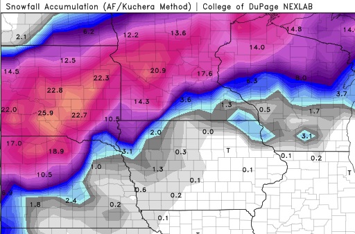
So of COURSE we’re looking at a monster snowstorm moving our way in 3-4 days. A low pressure system that’s currently moving onshore over the West Coast is expected to eject into the Plains on Wednesday and become another BOMB CYCLONE (it’s this year’s fun media-hyped weather buzzword, like Polar Vortex). Forecasts are, naturally, very wide-ranging in our area specifically, but it’s looking extremely likely that there will be a broad swath of land from western Nebraska to northern Minnesota that will get 12-18″ of snow, with embedded areas getting over 2 feet. Below is the latest GFS snowfall forecast through the event. It will be interesting to see how the system evolves over the next couple of days.
Just for reference, the biggest April snowstorm on record in the Twin Cities is 15.8″ set all the way back in… 2018. The 9th biggest storm of 9.0″ was also last year. This is not a trend I like to see continue, but alas, BUCKLE UP EVERYBODY. Winter is coming… well, I guess it hasn’t left at all.

