
After a quiet weekend, we are jumping back into the world of forecasting. Another big storm looms here in mid April, which is fine alongthe Gulf Coast, and might even be a little fun. Don’t ask about what it’s like up north.
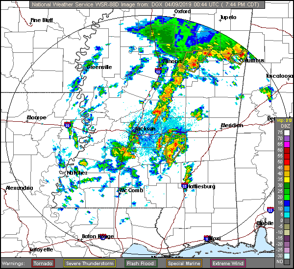
At 753PM, CT, Hattiesburg was reporting a temperature of 72 degrees and overcast skies. Central Mississippi was seeing an active weather night, as a clearly evident
And so it will be on Tuesday and Wednesday as upper level high pressure
Tomorrow – Mostly sunny, High 77, Low 63
Wednesday – Partly cloudy, warmer and more humid, High 85, Low 57
TWC: Tomorrow – A shower or two around the area in the morning, then partly cloudy in the afternoon. Thunder possible High 80, Low 61
Wednesday- A mainly sunny sky. High 86, Low 55
AW: Tomorrow – A passing morning shower; otherwise, mostly cloudy High 79, Low 63
Wednesday – Plenty of sunshine; warmer High 86, Low 54
NWS: Tomorrow – A 20 percent chance of showers before 10am. Cloudy, then gradually becoming mostly sunny, High 81, Low 62
Wednesday –
WB: Tomorrow – Mostly cloudy with a 20 percent chance of showers in the morning High 78, Low 63
Wednesday – Sunny, high 85, Low 55
WN: Tomorrow – Partly cloudy with isolated showers, High 81, Low 62
Wednesday – Sunny, High 84, Low 56
FIO: Tomorrow – Mostly cloudy until afternoon. High 80,
Wednesday – Clear throughout the day. High 86,
First, check out the radar, and the low pressure evident even on this map.
Now let’s check in with WJTV from Mississippi for the Pine Belt forecast.
Comment (1)