Oxnard, California to Palm Coast, Florida

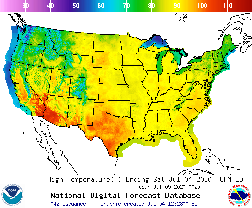
Happy 4th of July, everyone. The neighborhood fireworks are rocking my residence in celebration. We can celebrate the country by taking a cross country trip, which will be completed in 4 1/2 days, covering 2539 miles. That means our four full days will be consumed by 564 miles, thanks to the 70+mph afforded by these coronavirus emptied interstates.

DAY ONE (Sunday)

Oxnard
Oxnard, California

The first day of our trek is definitely going to be one that makes us wonder why anyone leaves the southwestern US. Not a cloud will be in the sky, save for one or two rising above the San Bernadino range very early in the day. The sweltering heat of southern Arizona may remind us of the rationale for living somewhere else, though, an our day will end in the outskirts of southeastern Tucson.

DAY TWO (Monday)
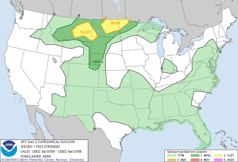
There will be some thunderstorms along our route on Monday, that’s one piece of news. The other piece of that news is that those storms will pop up after we’ve made our way through the region. The threat will come around El Paso, but that will fire up in the evening, as we are checking in for the night in Ozona, further to the east.

DAY THREE (Tuesday)
Driving through the San Antonio and Austin areas should be a pretty easy task, but closer to Houston, and perhaps as we pass into Louisiana, things may get a bit dicey iingering showers and storms associated with a lingering disturbance well east of our route (and the United States mainland, actually) and the ever present sea breeze could lead o a stray shower as we watch the show, wrapping things up ion Jennings, Louisiana, between Lake Charles and LAfayette.

DAY FOUR (Wednesday)
The drive along the Gulf Coast will be comfortably familiar for anyone who lives there. Quiet if hot and humid during the day, with an increasing threat for showers and thunderstorms as the instability gets to be too much. So after about 2, probably from Mobile eastward, we’ll have a real threat for showers and storms. Nothing too bad, but something that will definitely be there. We’ll stop in Madison, Florida, with a few hours to go on Thursday.

DAY FIVE (Thursday)
Some low pressure might organize late next week off the Carolina coast, which could provide some focus for thunderstorms in the southeast. IT’s for this reason that I would say thunderstorms might actually pop up in the morning in those last ew hours of our drive, rather than just with the peak heat. By the time we reach Jacksonville at the Atlantic coast, however, I think that storm threat will greatly abate. Stinkin’ hot, though.

Palm Coast, Florida

Super dewps

Never underestimate the ability of a high dew point to hold temperatures back. That was the case in College Station on Wednesday, with dew points in the 70s throughout the entire 24 (actually 48 hour period of the forecast), but another cause was a particularly vigorous onshore breeze that even let in a few drops of mist late in the day on Wednesday. Temperatures were a degree or two cooler than most outlets anticipated as a result. Generally, it was a decent forecast, though, with The Weather Channel and Accuweather claiming a tie.
Actuals: Tuesday – High 92. Low 81
Wednesday – High 94, Low 79

Grade: B-

Independence Day Ring of Fire

We’ve made it to the middle of summer, and the biggest summer holiday of them all. Some fireworks displays are still on, while others are cancelled out of an abundance of caution with the continued coronavirus pandemic. Whether or not we will get the patriotic displays, the atmosphere is certainly going to feel as it should on the 4th of July.

It’s going to be very hot for a lot of the country for Independence day, with 90s blanketing much of the country, save for the Pacific Northwest, where significantly cooler weather will take hold.

The overall pattern isn’t terribly strong, atmospherically, given there is a mountain range between the two air masses. There isn’t a vibrant jet structure to give rise to a solid dome of high pressure, but there isn’t organized low pressure either. Instead, we are looking at a pattern that will rely heavily on lower level features, which are provided more by the physical features at the surface than patterns in the atmosphere.

There is low pressure off shore, and sea breezes and weak oceanic circulation will lead to showers and storms along the east and Gulf coasts tomorrow. Lee troughing under zonal, west to east flow will lead to enough instability to lead to strong storms in the Plains, especially the northern High Plains, as noted in tomorrow’s SPC outlook map.

Large swaths of the country are going to be able to enjoy time on the lake or at the cabin, or perhaps watching fireworks displays from their decks or balconies. Socially distanced, of course.

Have a safe and happy 4th of July, everyone.

June Forecaster of the Month

Was it just me, or did June fly by? Maybe it was the extended vacation I took in the middle of the month, huh? Well, one outlet that appreciated it was the robot army of Forecast.io who thrived in the shorter session. Way to go, robot army!

OutletMonth wins
The Weather Channel1
Weatherbug1
Forecast.io1
Victoria-Weather
WeatherNation
National Weather Service
Accuweather
OutletMonth winsyear wins
The Weather Channel18
Weatherbug16.16
Victoria-Weather5.75
WeatherNation3.41
Forecast.io13.33
National Weather Service3.08
Accuweather2.25