Barry looms over Louisiana

Barry formed sloppily over the northern Gulf of Mexico late in the week before he made landfall near Intracoastal City, in the south central part of the state. The forecast was for a weak hurricane, at some point, and it was, but Barry made his landfall as a tropical storm.

The traditional concerns with a hurricane – wind and storm surge, looked to be mitigated by the general disarray of the storm even as he approached the coast. Note that the center of the storm is actually on the far north side of this batch of clouds, taken on Friday.
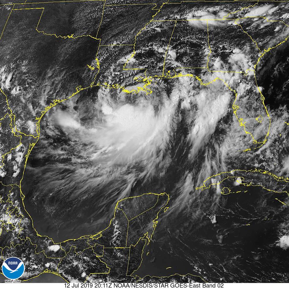
NOAA/NESDIS/STAR GOES ABI BAND 02 OR_ABI-L1b-RadC-M6C02_G16_s20191932011330_e20191932014103_c20191932014148.nc

There was no rain ahead of the storm either, but that has since changed. There is now a sizeable plume of heavy rain over eastern Louisiana, with more intense bands in central Mississippi.
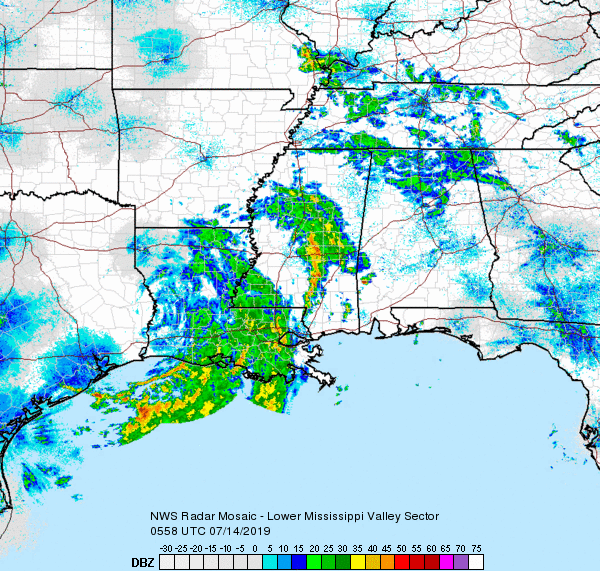
Barry isn’t sluggish, like Harvey a couple years ago, nor does it possess an otherworldly amount of rainfall, and isn’t very blustery. In most years, Barry would pass through inconvenient but forgotten

This year, however, the Plains have been beset by a whole lot of rain after an active late spring snow season. The Mississippi River was already up as a result of the upstream backlog, and now, Barry’s downpours will overwork the lower River and Delta. Fortunatley, the storm surge was mild, and in better news, the city of New Orleans sounds confident of the changes they have made post-Katrina. Nevertherless, Barry will continue to provide a threat for flash flooding in low lying areas in tbe far southern part of the state. Of course, the entire area is a low lying area, so be vigilant if you are riding this out in the bayous.
Coming soon…

It’s the hottest time of the summer, so let’s stay in the air conditioning and read about what’s going on outside. How does that sound?

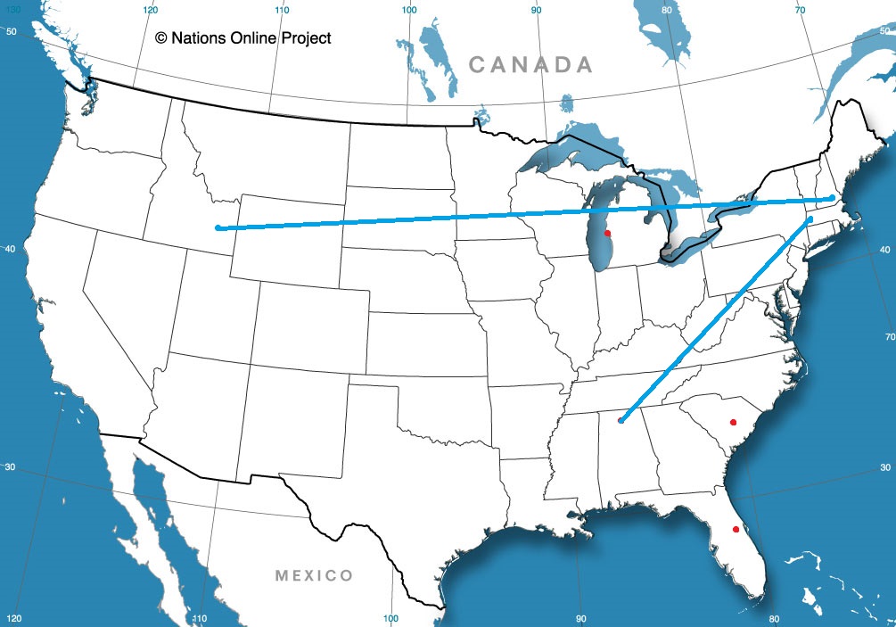
Road Trip from Pocatello, Idaho to Manchester, New Hampshire

Huntsville, Alabama
Road Trip from Pittsfield, Massachusetts to Huntsville

Deltona, Florida

Muskegon, Michigan

Sumter, South Carolina

A reminder: Thunderstorms are strong!

While strong synoptic scale systems, from Nor’Easters to Hurricanes are recognized for the sheer kinetic energy they possess over broad swaths of earth, it’s important to recognize that individual thunderstorms have an unbelievable amount of energy as well, and it’s all expressed faster and over a smaller area.

This video captures the flash flooding produced on Monday morning by a slow moving “every day” thunderstorm across the DC area. Even non-severe storms are capable of producing brisk winds, deadly lightning and as you can see, dangerous flash flooding, even if there aren’t any severe warnings (though this storm was waned for flash floods) and aen’t ultimately any severe reports.

Just another day in Southern Mississippi

First the good news: there were no thunderstorms last Wednesday or on the 4th of July for the city of Gulfport. Now the bad news: it was really stinkin’ hot. Low to mid 90s in the afternoon, and a low of 75 each morning. I hope the air worked for locals, or at least they have grown accustomed to sweating through the night. Accuweather had a dry forecast and the second best temperature forecast, which meant they started July off on a good note.
Actuals: Wednesday – High 92, low 75
Thursday – High 94, low 75

Grade: A-B

Tyler, Texas

Hi friends! I hope the holiday weekend left you recharged to attack the workweek. I think mine just made me want another week off!

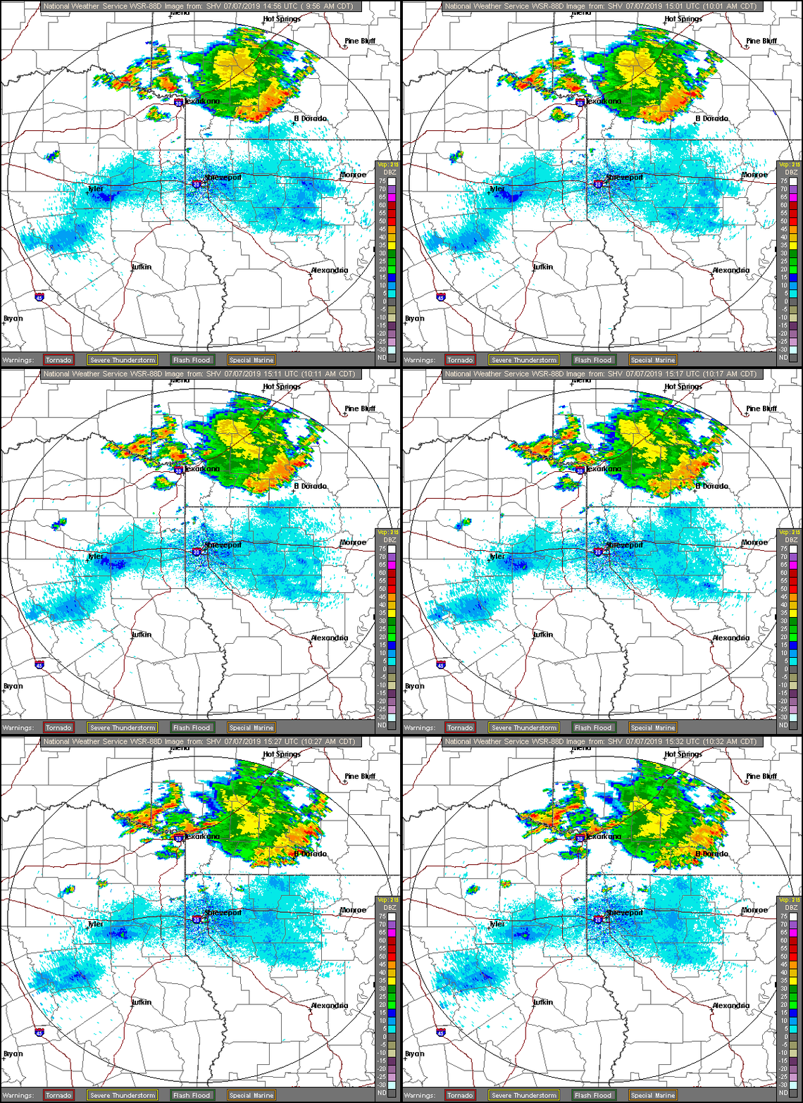
At 953AM, CT, Tyler was reporting a temperature of 85 degrees with sunny skies. Dew points were sultry, sitting in the mid to upper 70s across the region, feuling a surprisingly robust cluster of thunderstorms in southwest Arkansas, with some storms developing southwest into Texas, where a couple of cells were popping up just to the north of Tyler, and Gilmer was reporting thunder.
A very weak perturbation at the mid levels is sweeping through the region, beneath a similarly low powered ridge over the lower Mississippi Valley. This is enough to give some semblance of organization to the thunderstorm activity across the area, however widespread convection is likely across the southeast this afternoon as broadscale northwesterly flow trails some weak rotation centered over the Carolinas. Tyler will be at the western edge of this convective activity through mid afternoon tomorrow, and a stray thunderstorm cannot be ruled out. As low pressure organizes a bit over north Florida, and gets entrained with a trough over the Gulf Stream, The northwesterly flow will subside in Texas, but so too will the stream of moisture towards Tyler. Expect a hot and humid day on Tuesday, but without the threat for rain.
Tomorrow – Hot and partly cloudy with an isolated thunderstorm, High 94, Low 76
Tuesday – Mostly sunny, hot High 95, Low 75

TWC: Tomorrow – Partly cloudy. A stray shower or thunderstorm is possible High 95, Low 76
Tuesday – Mainly sunny. High 95, Low 76

AW: Tomorrow – Partly sunny; humid High 93, Low 75
Tuesday – Partial sunshine; humid High 94, Low 76

NWS: Tomorrow – Mostly sunny High 93, Low 76
Tuesday – Sunny, High 94, Low 75

WB: Tomorrow – Partly cloudy High 93, Low 76
Tuesday – Mostly sunny, High 94, Low 75

WN: Tomorrow – Partly cloudy, High 94, Low 76
Tuesday – Mostly sunny,, High 94, Low 75

FIO: Tomorrow – Humid and partly cloudy throughout the day.High 91, Low 73
Tuesday – Humid and partly cloudy throughout the day. High 91, Low 72

Guidance has already proven to be a bit too cool today, so I’m anticipating that to continue for the next couple of days. It looks like The Weather Channel and I are the only two on that bandwagon, as well as the threat for storms tomorrow. They ARE tops in the standings so far this year, so I think I picked a good partner. Here is radar, with a couple of storms popping up to the north.

June forecaster of the Month

For the first time as I can remember this year, an outlet thoroughly dominated the competition for a forecast period. The Weather Channel easily attained the top score this month, and they did it by winning or tying at the top spot on 4 of the month’s 6 rated forecasts. No stopping The Weather Channel, who now also takes the lead on forecasts wins for the year.

OutletMonth wins
The Weather Channel2.7
Weatherbug1.5
Forecast.io1
Victoria-Weather0.2
National Weather Service0.2
Accuweather0.2
WeatherNation0.2
OutletMonth winsyear wins
The Weather Channel2.79.95
Victoria-Weather0.27.7
Weatherbug1.57.58
Forecast.io16
National Weather Service0.25.45
Accuweather0.25.03
WeatherNation0.24.28

Gulfport, Mississippi

If you haven’t ever been to Gulfport, or know where it is located, Gulfport is a port on the Gulf.

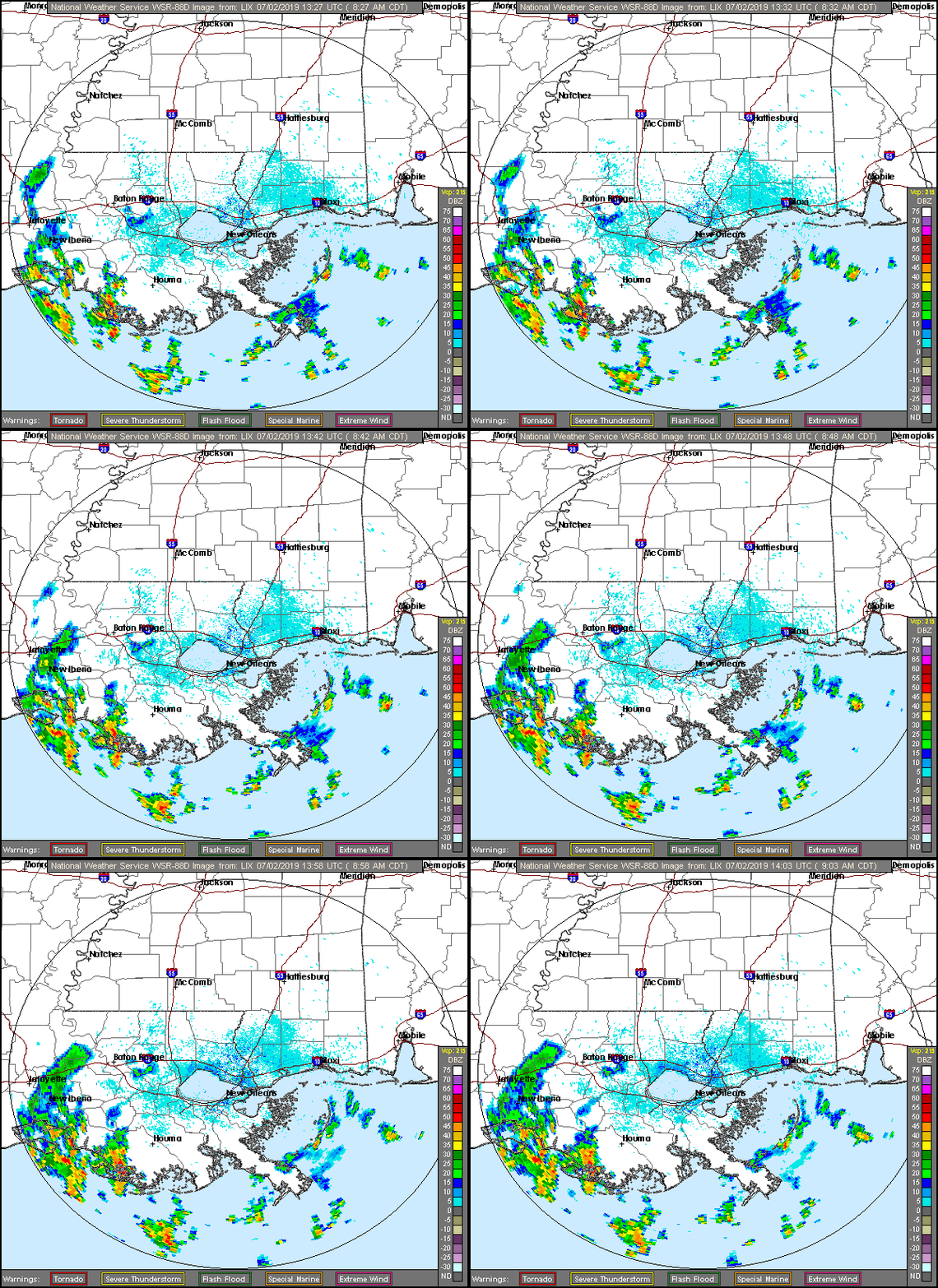
At 853AM, CT, Gulfport was reporting a temperature of 86 degrees with clear skies. It’s the season for light off shore convection, and indeed, there is already some off the Mississippi Delta. These Gulf Coast storms tend to be more widespread than anticipated in model guidance, and an intense rain shower cannot be ruled out today.
In the parlance, the Gulf is “open” meaning there is little to no counterflow to sea breezes, and sultry air is free to invade the coastal areas. This tends to mean that in the afternoon, there will be enough instability for occasional showers and thunderstorms, particularly a few miles inland where the sea breeze loses momentum, with storms then drifting back towards the coast as the sun sets. This will probably be the pattern each of the next two days in Gulfport, and truly, the entire Gulf Coast.
Tomorrow – Mostly cloudy with a few thunderstorms, High 93, Low 76
Thursday – Mostly cloudy with a few thunderstorms, High 95, Low 76

TWC: Tomorrow – Partial cloudiness early, with scattered showers and thunderstorms in the afternoon. High 90, Low 76
Thursday – Sunshine and clouds mixed. A stray shower or thunderstorm is possible High 93, low 77

AW: Tomorrow = Intervals of clouds and sunshine High 92, low 76
Thursday – Mostly sunny High 95, Low 76

NWS: Tomorrow – A 30 percent chance of showers and thunderstorms, mainly after 1pm. Partly sunny High 91, Low 76
Thursday – Mostly sunny, high 93, Low 76

WB: Tomorrow – Partly cloudy, slight chance of showers and thunderstorms in the morning, then chance of showers and thunderstorms in the afternoon, High 91, low 75
Thursday – Sunny in the morning then partly cloudy with a 20 percent chance of showers and thunderstorms in the afternoon High 93, low 75

WN: Tomorrow – Partly cloudy with scattered storms, High 92, low Low 77
Thursday – Partly cloudy, High 93, Low 77

FIO: Tomorrow – Humid and partly cloudy throughout the day. High 91, low 78
Thursday – Humid and partly cloudy throughout the day. High 93, Low 78

Hot. Humid. Mississippi. Here is some of this morning’s off shore convection on radar.

No rain and nasty temps

It was plenty warm in Nashville last week. temperatures soared into the low 90s in Nashville as the weekend commenced last week. there was a threat of some pop up showers and storms as is often the case south of the Ohio River this time of year, but Music City dodged the drops. The dry forecast meant Forecast.io was able to slip in front and win the forecast.
Actuals: Friday – High 91, Low 67
Saturday, High 92, Low 72

Grade: A-C

Madison, Wisconsin

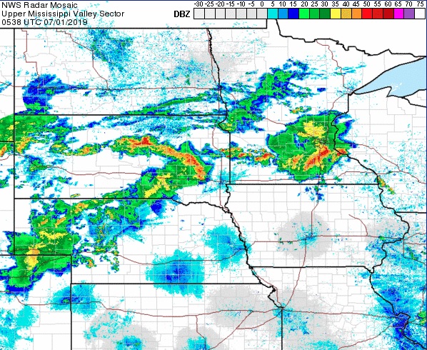
It’s been quite the active day here in the Upper Midwest, with Madison getting a morning line of storms and gusts to 40mph. It’s nothing like the 75mph gusts in Dubuque, not far off to the southwest, but still quite potent in its own right. Let’s take a look at how Wisconsin’s capital city will far as we start off the month of July.

At 853pm CDT, the temperature at Madison, WI was 71 degrees under mostly cloudy skies. A stationary boundary is camping out over the Upper Midwest, parked ahead of a slowly moving cold front through the northern Plains. Storms are expected to fire up over MN along this boundary Sunday evening and ride along it through WI, bringing some possible stormy weather to the area during the Monday morning hours. After this activity clears out, dry weather is expected for the afternoon and evening hours. An area of low pressure looks to shift through the region on Tuesday, bringing about another possible bout of showers and storms. Looks like it’s going to be a noisy start to the month!

Monday: Chance of morning showers/storms. High 87, Low 66.
Tuesday: Isolated afternoon thunderstorm. High 88, Low 71.

TWC: Monday: Afternoon thunderstorms. High 89, Low 69.
Tuesday: Scattered thunderstorms. High 87, Low 71.

AW: Monday: A shower and thunderstorm around. High 88, Low 70.
Tuesday: Strong storms, mainly later. High 85, Low 72.

NWS: Monday: Severe thunderstorms and patchy fog. High 87, Low 68.
Tuesday: Chance of thunderstorms. High 83, Low 72.

WB: Monday: Chance of storms. High 86, Low 71.
Tuesday: Chance of storms. High 85, Low 73.

WN: Monday: Partly cloudy with isolated storms. High 87, Low 68.
Tuesday: Partly cloudy with scattered storms. High 83, Low 72.

FIO: Monday: Rain tonight. High 88, Low 70.
Tuesday: Possible light rain in the evening. High 83, Low 72.

Madison is quiet, for now. However, we see strong storms developing in MN this evening, and it looks like these could slide into southern WI during the morning hours tomorrow.

Casper, Wyoming

As temperatures are expected to soar here in the Upper Midwest this weekend, let’s venture to the Rockies and take a peek at how things will pan out in Central Wyoming!

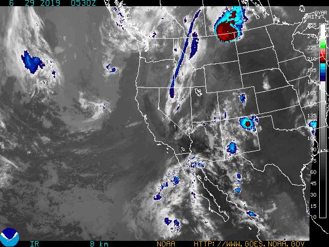
At 1120pm MDT, the temperature at Casper, WY was 61 degrees under fair skies. Low pressure found over the Northern High Plains will shift its way into Central Canada throughout the day Saturday, trailing a boundary back into the Great Basin. Luckily for Casper, the main focus of any precip will be over the Dakotas as hot, humid air streams northward into the Northern Plains/Upper Midwest, kicking up storms off to the east. Low pressure that develops over the Great Basin Saturday shifts into the Central Rockies on Sunday. This increased cloud clover will bring much lower temps during the day, and as the overall boundary sags a bit southward, chances for showers and isolated thunderstorms Sunday evening increases.

Saturday: Mostly sunny. High 92, Low 57.
Sunday: Increasing clouds and cooler. Possible evening thunderstorms. High 81, Low 54.

TWC: Saturday: Mostly sunny. High 93, Low 55.
Sunday: Cloudy, isolated showers. High 80, Low 54.

AW: Saturday: Partly sunny; hot. High 91, Low 55.
Sunday: Mainly cloudy; not as warm. High 80, Low 52.

NWS: Saturday: Sunny then mostly sunny and breezy. High 91, Low 53.
Sunday: Mostly cloudy then chance of thunderstorms. High 85, Low 59.

WB: Saturday: Mostly sunny. High 89, Low 58.
Sunday: Chance of thunderstorms. High 77, Low 53.

WN: Saturday: Mostly sunny. High 91, Low 53.
Sunday: Mostly cloudy with scattered storms. High 85, Low 59.

FIO: Saturday: Foggy, then partly cloudy. High 93, Low 63.
Sunday: Mostly cloudy throughout the day, isolated showers. High 83, Low 58.

We see a fairly quiet pattern over Wyoming, while a thunderstorm complex is keeping things interesting along the Canadian border.