We took a look at the central Valley in California early last week, and it was a pretty tough verification. Not, perhaps, in the way you think. Fresno wasn’t going to see much
Actuals: Monday High 102, Low 72
Tuesday – High 99,
Grade: B
from Victoria-Weather

We took a look at the central Valley in California early last week, and it was a pretty tough verification. Not, perhaps, in the way you think. Fresno wasn’t going to see much
Actuals: Monday High 102, Low 72
Tuesday – High 99,
Grade: B
The Carolinas were clipped by Dorian, with coastal sections of the states from Charleston to the Outer Banks sustaining damage, primarly due to storm surge and some isolated tornadoes, like the one in North Myrtle Beach. Greensboro was largely unaffected, and now can look instead to the west for their upcoming weather.
At 1152AM, ET, Greensboro was reporting a temperature of 79 degrees with fair skies. There was a little bit of cloud cover across the region, but not so much that the satellite was very busy. A stalled boundary suspended between two areas of low pressure in the Great Lakes was inducing a generally southerly flow, which will likely lead to low clouds and fog when temperatures start to wane.
The western low will start to occlude, while the cold front attached to the boundary to the east will begin to sink further south, decoupling from the western low. There won’t be much energy with the tail of this front as it passes into North Carolina, but after sunset, destabilization aloft might lead to a few showers and storms on Friday evening.
Tomorrow – Sunny and humid, High 92, Low 73
Friday – Mostly cloudy with increasing chances of rain. Cooler, High 83, Low 71
TWC: Tomorrow – Except for a few afternoon clouds, mainly sunny. high 95, Low 72
Friday – Scattered thunderstorms High 81, Low 71
AW: Tomorrow – Mostly sunny, hot, High 94, Low 71
Friday – Intervals of clouds and sun, a couple of showers and a thunderstorm, mainly later; warm High 83, low 72
NWS: Tomorrow – A slight chance of showers and thunderstorms after 2pm. Patchy fog before 9am. Otherwise, sunny, High 94, Low 71
Friday – A chance of showers and thunderstorms, mainly after 1pm. Increasing clouds, High 86, Low 70
WB: Tomorrow – Sunny. Patchy fog in the morning. A slight chance of showers and thunderstorms in the afternoon. High 93, Low 73
Friday – Partly sunny. A chance of showers and thunderstorms in the afternoon, High 83, Low 73
WN: Tomorrow – Partly cloudy with isolated storms, High 94, low 72
Friday – Partly cloudy with scattered storms, High 86, Low 70
FIO: Tomorrow – Humid and mostly cloudy throughout the day. High 93, Low 70
Friday – Humid and partly cloudy throughout the day. High 84, low 70
Model guidance suggests that temperatures will actually be in the high 70s on Friday, but note how nobody is on board with that. This is because guidance often fails to cope with terrain’s influence on temperature. That heavy, cold air will struggle to clear Appalachia, and with a blanket of mid level clouds, radiative cooling will be unlikely. Here is the satellite, with no clouds to speak of this morning.
By now, we’ve all heard the stories of utter devastation for the northern Bahamian islands of Great Abaco and Grand Bahama. The initial storm surge put a lot of Abaco underwater at the initial landfall, and many deaths on the island were the result of drowning during the storm surge, while in this case, the eye’s passage overhead provided a chance for many to get to higher, safer ground.
The storm then sat and spun over the eastern side of Grand Bahama, cutting the largest city, Freeport, off from the rest of the island. The destruction there, thanks to persistent triple digit wind speeds and a very high storm surge, is comprehensive.
Dorian’s slow down fortunately spared the Floridian coast from the worst damage, but the storm spiraled northwards and pummeled Georgia and the Carolinas with rain, storm surge, tornadoes and category 2-3 winds, before it made a brief trek over the Outer Banks, with a landfall at Cape Hatteras. Take a look at the radar imagery to see how close the eye was to Charleston and Wilmington at various points.
Dorian moved away from the Carolina coast and as he weakened, broadened his footprint, meaning more rain and cloud cover further from the center of the storm. A course directly up the Gulf Stream and away from land will allow for
Dorian tracked directly over Halifax, Nova Scotia with hurricane strength winds, and thought it didn’t approach the intensity it had when the storm swept through the Bahamas, he did considerable damage there as well.
The above video provides a good recap of the
If you can help out and choose to do so, the Red Cross is always accepting donations.
All eyes remain on Dorian as he batters the northern Bahamas, and we can openly speculate on his further track. It appears as though his course will mean a greater threat for the Carolinas than Florida. Last year, California bore the brunt of weather headlines for much of the year, thanks to drought and fires. This year, California is mercifully off the radar. Let’s check back in.
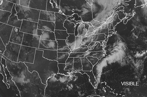
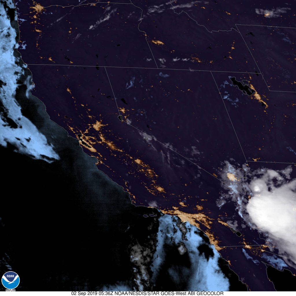
At 953PM, PT, Fresno was reporting fair skies and a temperature of 87 degrees. While not humid, the dew point was certainly a bit warmer than normal for central California. Despite that, the Golden State was clear, though the monsoon was active with heavy storms over Arizona.
Monsoonal activity will diminish tomorrow, though some high peak showers and storms will be possible, but settled into the valley, a little bit of morning haze will burn off quickly, with hot sunny skies in the afternoons.
Tomorrow – Sunny and hot, High 102, Low 72
Tuesday – Sunny and hot High 102, Low 74
TWC – Mostly sunny skies. High 103,
Tuesday – Mainly sunny. High 102,
AW: Tomorrow – Mostly sunny;
Tuesday – Mostly sunny; hot High 102, Low 72
NWS: Tomorrow – Sunny and hot, High 100, Low 73
Tuesday – Sunny and hot, High 100, Low 73
WB: Tomorrow – Sunny, High 102, Low 74
Tuesday – Sunny, High 101, Low 74
WN: Tomorrow – Sunny, High 100, Low 73
Tuesday – Sunny, High 100, Low 73
FIO: Tomorrow – Partly cloudy throughout the day. High 103,
Tuesday – Clear throughout the day. High 103, Low 71
The forecast is quite warm, but it’s interesting that the Weather Service is the coolest outlook. That’s not how it usually goes.
The forecast in Monroe seemed promising. There was a little bit of rain in the early part of Wednesday, but then the heat was supposed to break. It certainly did not. Instead, high temperatures remained in the mid 90s, which was just as hot as it was before a weak cold front slid through. The National Weather Service and
Actuals: Wednesday – Thunderstorms reported, not measured, High 95, Low 72
Thursday – High 95, Low 70
Grade: C
Because of the slowed down pace, Dorian was able to deepen further than forecasts originally expected, and has become a Category 5 storm as it bears down on the northern Bahamas. It has developed a well defined eye, as a symbol of
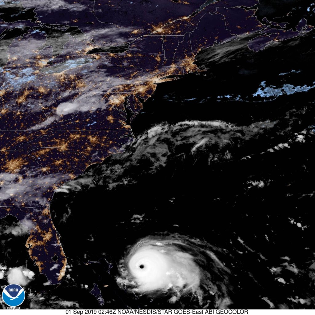
That’s a remarkable satellite image, in all of the worst ways. Dorian is going to prove very dangerous to the northernmost islands of the Bahamas, and it appeared he was on his way to becoming the strongest storm to hit the east coast of Florida since Andrew, but alas, that slow pace may have spared Florida the worst.
The NHC maintains warnings for the northern Bahamas, particularly Great Abaco and Grand Bahama, which look to bear Dorian’s full brunt over the weekend, but at this time, only a tropical storm warning has been issued for a small stretch of Floridian coastline.
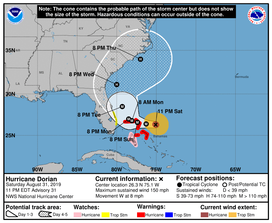
Dorian remains a danger, of course. The Bahamas in particular are in imminent danger, and even if the storm stays
Dorian has just now been upgraded to hurricane status. He presently sits to the east of Puerto Rico, and will move across the virginiaIslands. Forecast trends have been for a slower progression, a bit removed from the Bahamas, both of which are trends that indicate a stronger storm than had been originally forecast.
Not last week, we were discussing the timid nature of Chantal, as she spun into the north Atlantic. Dorian was initially thought to be another fish storm (after he encountered the Lesser Antillies, of course) but now, the storm is getting slower, and is missing out on the steering flow that instead grabbed the short lived Erin, who is now spiraling off after Chantal.
Dorian is now expected to swing north of the Bahamas before curling back to the west towards Cape Canaveral in about 5 days time, with a landfall sometime this weekend. This is still quite a ways out, and there is certainly plenty of time for things to change, a caveat that is always in place for tropical features, but things aren’t breaking well in the last 48 hours.
A slower course will allow it more time to ingest warm, energizing ocean water, which would have been ok, if it had continued on it’s original course over Puerto Rico and Hispaniola, and through the Bahamas. Instead, it’s jogged east and north, avoiding most of the major landmasses in his way. Now, Dorian, which looks to take an unimpeded run at the Florida coast, may arrive as a major hurricane over Labor Day weekend.
If high pressure doesn’t develop with the strength expected over Bermuda, the storm may shift north, but if it does, it will press south. If the storm tracks directly over some islands, or shear is greater than expected, then Dorian will end up weaker as he landfalls on the Florida Coast. Unfortunately, none of those things seem as though they are expected to come to fruition.
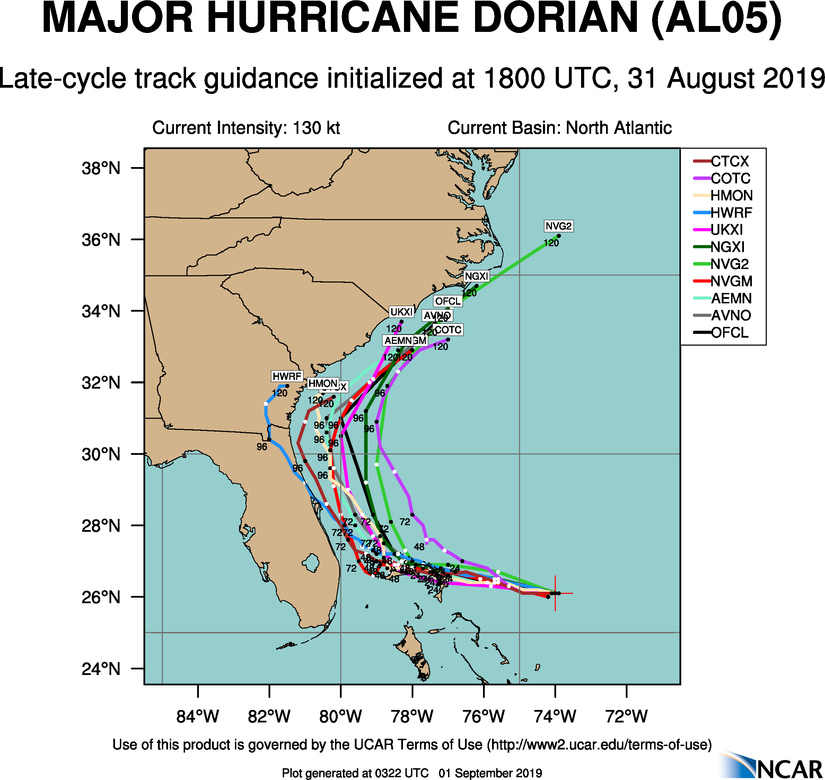
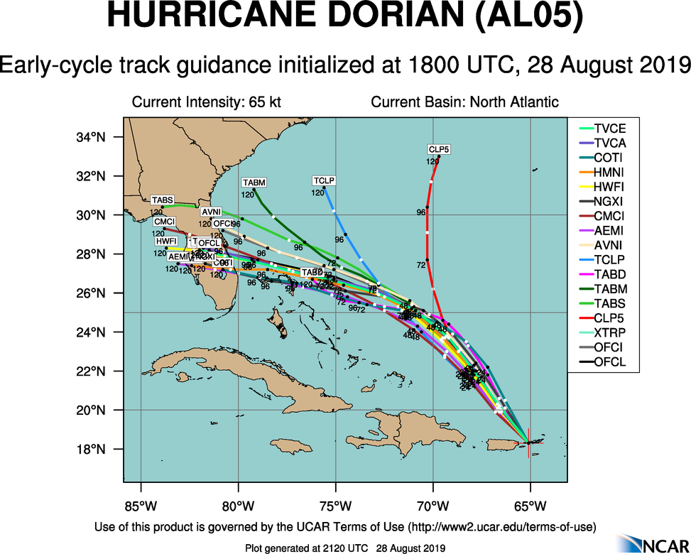
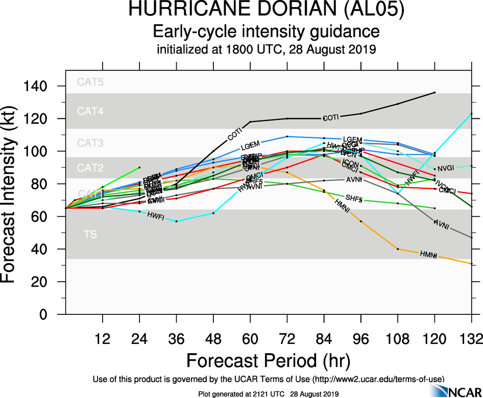
The below track and intensity projections don’t ingest the European model. If they did, they would likely be more aggressive on a land fall closer to Vero Beach and Fort Pierce, with a bit more of an intensity peak at landfall. We’ll try to keep you updated here and on Twitter.
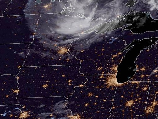
As we head into midweek and draw ever closer to the end of Meteorological Summer, let’s head to central IL and see what’s in store for Peoria!
At 1154pm CDT, the temperature at Peoria, IL was 64 degrees under fair skies. A large dome of high pressure is found over the region, making for very pleasant conditions as we head into midweek. This area of low pressure is going to shift off to the south and east during the day, however, as a cold front pushes through the Upper Midwest. While the main impacts of the front look to be off to the north and east, the tail end of the front looks to move through during the evening hours, which could bring some scattered showers and an isolated thunderstorm to the area. No washouts are expected from it, but don’t be surprised if you have to dodge a dinnertime shower.
Wednesday: Sunny and pleasant. High 79, Low 57.
Thursday: Mostly sunny, isolated evening shower. High 86, Low 60.
TWC: Wednesday: Sunny. High 80, Low 58.
Thursday: Afternoon thunderstorms. High 88, Low 56.
AW: Wednesday: Mostly sunny; pleasant. High 78, Low 56.
Thursday: Sunshine; pleasant. High 84, Low 56.
NWS: Wednesday: Sunny. High 77, Low 56.
Thursday: Sunny. High 85, Low 56.
WB: Wednesday: Sunny. High 78, Low 57.
Thursday: Sunny. High 84, Low 57.
WN: Wednesday: Sunny. High 77, Low 56.
Thursday: Mostly sunny. High 85, Low 56.
FIO: Wednesday: Clear throughout the day. High 77, Low 54.
Thursday: Possible light rain in the evening. High 84, Low 54.
We see the swirl of clouds associated with an area of low pressure over northern MN, but central IL is pretty quiet tonight. That seems to be the story for the next couple days as well.
Today’s forecast brings us to northern Louisiana. The weather here tends to be less ‘coastal’ and seems to be more at the mercy of the factors that drive the weather elsewhere in the southern Plains and lower Mississippi Valley.
At 818AM. CT, Monroe was reporting light rain with a temperature of 77 degrees. A large area of showers and thunderstorms lingered over northeast Texas, and extended a narrow tendril of rain through northern Louisiana. This outflow boundary suggested that the overnight convection was dissipating for the time being, but it seemed unlikely that the storm machine would be out of commission very long.
A deep area of low pressure was spinning in western Ontario, draping a long, winterlike cold front through the Plains and into the Red River Valley. The length and orientation of the boundary seemed to indicate that the feature wouldn’t be moving with any urgency. The scattered showers and thunderstorms will be an ongoing threat today into tonight. the front will linger over central Louisiana through the day tomorrow, which might mean some more clouds and spots of rain. The low will shift to the northeast through the period, and this will allow the front to diminish. high pressure will take over for Thursday, and it may be a tick cooler than it’s been lately over the next couple of days.
Tomorrow – Mostly cloudy, with isolated showers, High 86, Low 74
Thursday – Mostly sunny, High 91, Low 70
TWC: Tomorrow – Thunderstorms likely in the morning. Then the chance of scattered thunderstorms in the afternoon. High 89, low 74
Thursday – Sunny skies. High 90, Low 69
AW: Tomorrow – Intervals of clouds and sun, a couple of showers and a thunderstorm High 87, Low 74
Thursday – Partly sunny High 91, Low 68
NWS: Tomorrow – A 50 percent chance of showers and thunderstorms. Mostly cloudy High 90, Low 74
Thursday -Sunny, High 92, low 69
WB: Tomorrow – Mostly cloudy with a 50% chance of showers and thunderstorms, High 88, Low 74
Thursday – Mostly sunny, High 89, low 70
WN: Tomorrow – Mostly cloudy with scattered storms, high 90, low 74
Thursday – Mostly sunny, High 92, Low 69
FIO: Tomorrow – Light rain tonight and tomorrow morning. High 86, Low 75
Thursday – Clear throughout the day. High 89, Low 70
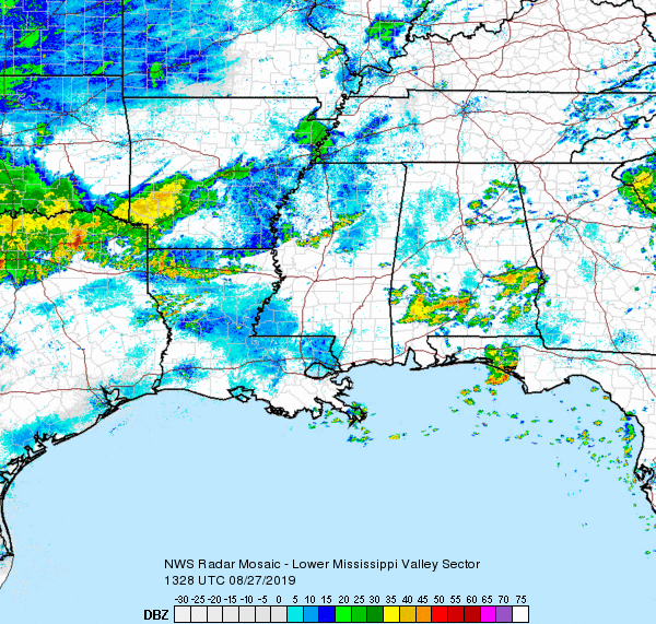
The radar in Jackson is out, so we will take a look at the big picture. That bowl shaped band of showers moving through the northern parishes of Louisiana is caused by storms to the north beginning to collapse.
Everything is bigger in Texas, or so they say. The temperature readings were pretty huge in San Antonio on the 19th and 20th, with the highs reaching triple digits on the 19th, and the upper 90s on the 20th, all while failing to dip below 80 for the overnight lows. That is a big time heat wave. Forecasts all circled the same numbers, so there wasn’t much separation, but a nearer high on the 20th gave Weatherbug the victory.
Actuals: August 19th – High 100, Low 80
August 20th – High 97, low 80
Grade :B