Another quiet-ish week of forecasting this week. Anthony will jump in with his usual allotment of outlooks, but I’ve only got a couple of forecasts on my docket.
Fresno, California
Greensboro, North Carolina
from Victoria-Weather

Another quiet-ish week of forecasting this week. Anthony will jump in with his usual allotment of outlooks, but I’ve only got a couple of forecasts on my docket.
Fresno, California
Greensboro, North Carolina
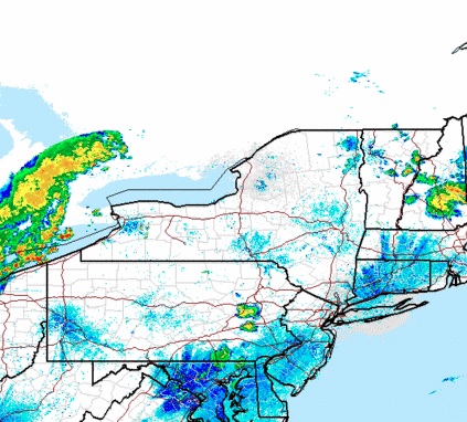
As we head into the weekend, let’s take a trip to the Gulf Coast and see how the weather is shaping up for Beaumont, TX. Will it be sunny beach weather or will be be scampering for cover?
At 853pm CDT, the temperature at Beaumont, TX was 83 degrees under partly cloudy skies. A frontal boundary looks to sag southward into portions of the Deep South over the next couple of days, but won’t make it anywhere near the Gulf Coast. A typical summertime pattern looks to be in place, with plenty of heat and low-level moisture fueling afternoon thunderstorms in the area. Friday looks to have the better chance of the 2 days in seeing thunderstorms, but Saturday will certainly see it’s share of activity in the vicinity. It doesn’t look like the days will be a washout, but if you’re going out and about, make sure you don’t leave the car windows open.
Friday: Cloudy, scattered storms. High 88, Low 77.
Saturday: Mostly cloudy, continued storm activity. High 88, Low 76.
TWC: Friday: Scattered thunderstorms. High 86, Low 75.
Saturday: Scattered thunderstorms. High 87, Low 75.
AW: Friday: Showers and a heavier tstm. High 84, Low 76.
Saturday: A shower or heavy tstm. High 88, Low 75.
NWS: Friday: Thunderstorms expected. High 87, Low 76.
Saturday: Thunderstorms likely. High 89, Low 75.
WB: Friday: Thunderstorms. High 83, Low 77.
Saturday: Chance of thunderstorms. High 85, Low 76.
WN: Friday: Mostly cloudy with light showers. High 87, Low 76.
Saturday: Partly cloudy with thunderstorms likely. High 89, Low 75.
FIO: Friday: Rain starting in morning, continues into evening. High 85, Low 78.
Saturday: Possible light rain starting in morning. High 87, Low 77.
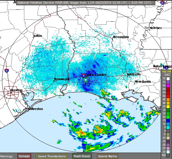
Scattered shower and thunderstorms have shifted out over the Gulf of Mexico tonight. However, additional thunderstorms are expected to develop during the afternoon hours the next couple of days.
Utica got the slightest bit of rain Monday morning as dissipating activity gave the city just enough to nudge the rain gauge. The rest of the day and Tuesday was fairly pleasant, though the morning lows were a smidge lower than most expected. Us here at VW anticipated that, however, and rode those cooler morning lows to an easy victory.
Monday: 0.01″ in a morning shower. High 82, Low 64.
Tuesday: High 82, Low 57.
Forecast Grade: A
Tropical Storm names recycle every 6 years, unless they are retired. The powers that be update their lists every once in a great while, but Chantal has been a part of the lists since 1983, a solid 36 years, and six total cycles. Once, in 1989, a Chantal emerged in the Gulf and began dissipating as she hit the Texas Coast. That was the last time we have seen a Chantal of any significance.
2003’s Chantal was as close as we’ve come to remembering any Chantals, with $5mm of damage to the coastline of Belize. All told, given the scope of damage a hurricane can introduce, that’s pretty much coming away Scot free.
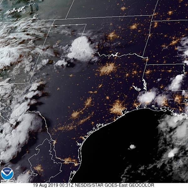
But it’s still more than most Chantals can say, including the one that just formed in the way north Atlantic over the last 48 hours. Check out the current satellite imagery of the storm.
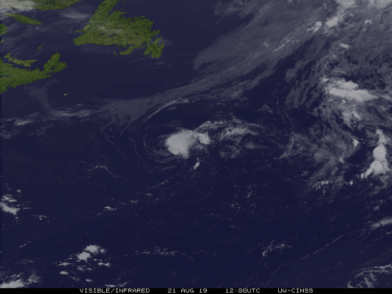
Not only is Chantal disorganized, but the closest island is Newfoundland. This Chantal is going to be just as uneventful as previous iterations.
After a busy couple of years, not only is Chantal harmlessly out to sea, she is also the first storm in months. Granted, we are approaching the peak of the season, but there isn’t any development looming quite yet. With any luck, this entire hurricane season is one big Chantal.
We are going to head right into the heat here in the dog days of summer. There will be a point where we have to pass through some storms to get from moderately more tranquil weather in New England to the steamy south, but where will it happen along our 2013 mile journey? And when, over the 4 day trek? As you might be able to establish, we will cover a bit more than 500 miles a day (519, actually) while traveling at a pace just shy of 65mph, which is somewhat slow, thanks to the tangled web of the east coast, and not a fear of impending thunderstorms.

DAY ONE (Tuesday)
Naturally, the feature first expected to impact our journey will be a weak shortwave trough moving out of the Great Lakes. Why is this great? Because I’m being sarcastic, and this will be difficult to forecast around. There is consensus that we will be dry through the New York City area, but then it becomes a little dodgier. I think the model that brings a lot of rain to Pennsylvania is doing so because of poor resolution. I think it’s going to generally be mostly cloudy with some isolated spots of rain, but maybe not enough to even turn the wipers on. These dots will be possible for the rest of the journey, though becoming less likely as we pass into Virginia. The day will end in New Market, Virginia, in the northern part of the state.
DAY TWO (Wednesday)
Another wave moving into the Great Lakes is going to carry with it a bit more weight. Inflow towards the low might lead to some fog and haze in the Appalachians and Smokey Mountains, but the potential for heavy thunderstorms will arise in Tennessee. Not widespread, destructive thunderstorms, mind you, but isolated, pop up showers and storms of questionable coverage. The strongest storms will stay west of the Appalachians, and coverage will begin to wane as a strong batch of
DAY THREE (Thursday)
I’m not in the market for going out
DAY FOUR (Friday)
That at times steady rain, with a few embedded thunderstorms, will continue through western Louisiana, and may even remain a concern as deep into Texas as Houston, but after we reach the western suburbs, I think we are in the clear. Just in time for more oppressive heat! At least there will be a few clouds every here and there, but not enough to make things feel significantly diffeent in San Antonio than they did in Providence.

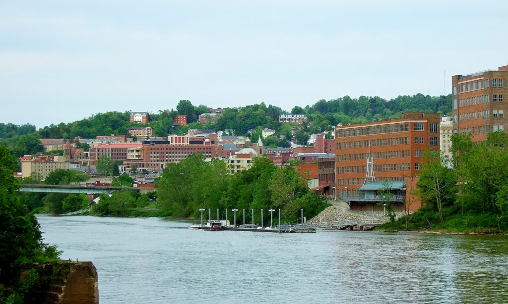
Today we’re heading to Central NY and taking a closer look at Utica, NY to start the workweek.
At 1153pm EDT, the temperature at Utica, NY (officially nearby Griffiss AFB) was 68 degrees with a few clouds. The tail end of a cold front is shifting its way through the Northeast, and with it showers and thunderstorms are moving through the Great Lakes. While thunderstorm activity should be winding down by the time activity moves through, there could still be a cell or two that affects the region. Otherwise, general rain showers are anticipated before conditions clear out for the afternoon. High pressure shifts in for Tuesday and brings with it sunnier skies and pleasant conditions!
Monday: Morning rain/possible storm, clearing late. High 83, Low 65.
Tuesday: Mostly sunny. High 81, Low 57.
TWC: Monday: Scattered thunderstorms. High 83, Low 67.
Tuesday: Mostly sunny. High 84, Low 59.
AW: Monday: A shower or tstorm in spots. High 84, Low 68.
Tuesday: Mostly sunny; less humid. High 83, Low 62.
NWS: Monday: Showers then slight chance of storms. High 85, Low 66.
Tuesday: Mostly sunny then slight chance of showers. High 83, Low 61.
WB: Monday: Chance of thunderstorms. High 81, Low 69.
Tuesday: Partly sunny. High 81, Low 59.
WN: Monday: Partly cloudy with light showers. High 86, Low 67.
Tuesday: Partly cloudy with isolated showers. High 85, Low 63.
FIO: Monday: Morning rain then partly cloudy. High 83, Low 67.
Tuesday: Partly cloudy throughout the day. high 85, Low 60.
The Utica area is quiet currently, but storms off to the west will be approaching through the morning hours.
The forecast for Birmingham was a fairly straightforward one, dry and HOT. Which is was, no doubt about that. The morning lows were a couple degrees cooler than most had anticipated however, which lead to some higher than average scores given the comparatively benign pattern. NWS and WeatherNation split top billing.
Friday: High 98, Low 67.
Saturday: High 100, Low 67.
Forecast Grade: B
Let’s take a look at the southern part of Texas, where it’s going to be extra hot and extra sticky.
At 751PM, San Antonio was reporting a temperature of 94 with a dew point of 70. Clear skies covered eastern and downstate Texas, though the dry line was active on
The anticyclonic flow is going to dissipate over the next 48 hours, with a return flow setting up along the Sabine River but not any further to the west. San Antonio looks to remain dry if uncomfortably warm to begin the workweek.
Tomorrow – Mostly sunny, High 99, Low 78
Tuesday – Still hot, High 99, Low 79
TWC: Tomorrow – Partly cloudy skies High 99, Low 78
Tuesday – A few clouds from time to time. Continued very hot. High 99, Low 78
AW: Tomorrow – Mostly sunny; very warm High 100, Low 79
Tuesday – Mostly sunny; very warm High 101, Low 78
NWS: Tomorrow – Mostly sunny and hot, High 100, Low 79
Tuesday – Mostly sunny and hot, High 100, Low 78
WB: Tomorrow – Mostly cloudy in the morning, then clearing. High 98,
Tuesday – Partly cloudy. High 97, Low 78
WN: Tomorrow – Partly cloudy, High 100, Low 79
Tuesday – Partly cloudy, High 100, Low 78
FIO: Tomorrow – Humid and partly cloudy throughout the day. High 98,
Tuesday – Humid and partly cloudy throughout the day. High 99, Low 78
Here is the satellite, with some puffs developing in west Texas.
Today we embark on a 2-day, 677-mile trek through the Appalachians to the Deep South. We could probably get this one in one very long day, but we’re gonna take our time and enjoy some scenery!
DAY ONE
High pressure is found over the OH and TN Valleys, keeping much of the region dry into the Central and Southern Appalachians. A sunny day is expected as we head south out of Morgantown through WV and through western Virginia. Continued pleasant but hot conditions are anticipated for the rest of the day as we end this leg in Knoxville.
DAY TWO
As high pressure continues to control the region, more sunny skies and dry conditions are expected for the rest of the trip. Temperatures are expected to hit the triple digits as we head past Chattanooga into Alabama and eventually into Birmingham, but at least the trip will be dry!

As we look forward to the weekend, let’s head to the Deep South and see how the historic city of Birmingham will fare!
At 953pm CDT, the temperature at Birmingham, AL was 80 degrees under fair skies. It’s been nothing short of ridiculously hot over the Southeast this past week as I mentioned a few days ago, and it doesn’t look like it’s gonna go anywhere soon. A strong ridge of high pressure is continuing to sit over the Deep South and will park itself there for another couple of days yet. It will break down a bit on Sunday and a chance of thunderstorms will re-enter the forecast. But until then, it’ll be dry but scorching hot!
Friday: Sunny and hot. High 95, Low 71.
Saturday: Sunny and even hotter. High 96, Low 69.
TWC: Friday: Sunny. High 96, Low 70.
Saturday: Sunny. High 98, Low 70.
AW: Friday: Mostly sunny. High 96, Low 70.
Saturday: Mostly sunny; hot. High 98, Low 68.
NWS: Friday: Sunny. High 98, Low 70.
Saturday: Hot. High 100, Low 71.
WB: Friday: Sunny. High 95, Low 71.
Saturday: Sunny. High 97, Low 70.
WN: Friday: Sunny. High 98, Low 70.
Saturday: Mostly sunny. High 100, Low 71.
FIO: Friday: Clear throughout the day. High 95, Low 70.
Saturday: Clear throughout the day. High 97, Low 69.
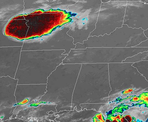
The Deep South is extremely quiet tonight, and looks to remain that way as we head into the weekend. Just don’t look at that cluster of severe thunderstorms in MO/NE. Nothing to see here folks!