As we saw with our monthly review earlier today, we haven’t been terribly active with our forecasts lately and, well, that doesn’t seem to be likely to change in the near future. We’ll still try to make sure to that everyone has a good look at everything that’s going on out there.
We didn’t really do a lot of forecasting this month, as most of our attention was tied to the dangerous and persistent tropical season. Dorian and Imelda took a lot of our attention, but when we were, albeit briefly, focused on the Mainland, it was WeatherNation who snuck in for a victory.
As we head into the first weekend of October, we head into southeast TX to take a look at College Station, home of Texas A&M! Can we expect some football weather or is the south still holding on to a bit of summer?
At 953pm CDT, the temperature at College Station, TX was 83 degrees under fair skies. Normally the people of the city would be gearing up for a big Football Saturday and root their Aggies on, but not this weekend as it’s a bye week for them. Luckily, the fans don’t have to be outside watching them play as it’s shaping up to be a very hot weekend in southeast TX. Weak high pressure continues to linger over the region while the main dome of it is parked well out east. An area of low pressure is shifting through the Central Plains into the Upper Midwest and while it will bring rain and thunderstorms from MN/WI down into KS/OK, it’s going to be pretty quiet on Saturday as just some isolated thunderstorms may pop off towards the LA/TX border. The cold front dropping through the Plains will gain more steam throughout the day on Sunday, bringing showers and storms to AR/OK and northern TX, but by the time the front makes it to the area, it should be during the early Monday morning hours. In the meantime, temperatures look to hit the mid-90s all weekend. A sweltering start to October!
Saturday: Partly cloudy and hot. High 94, Low 72.
Sunday: Partly cloudy, continued hot. High 95, Low 72.
TWC: Saturday: Mostly sunny. High 95, Low 72.
Sunday: Mostly sunny. High 95, Low 73.
AW: Saturday: Mostly sunny. High 95, Low 71.
Sunday: Mostly sunny and hot. High 94, Low 72.
NWS: Saturday: Sunny. High 95, Low 73.
Sunday: Sunny. High 94, Low 72.
WB: Saturday: Mostly sunny. High 94, Low 74.
Sunday: Partly cloudy. High 93, Low 74.
WN: Saturday: Mostly sunny. High 95, Low 72.
Sunday: Mostly sunny. High 94, Low 73.
FIO: Saturday: Humid and partly cloudy throughout the day. High 94, Low 72.
Sunday: Partly cloudy throughout the day. High 94, Low 71.
It’s a quiet night for the most part around southeast TX tonight, some storms are lingering east of Houston. A fairly quiet couple of days are in store so enjoy this hot weekend!
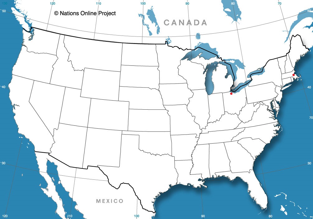
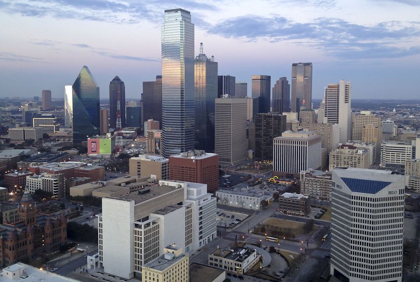
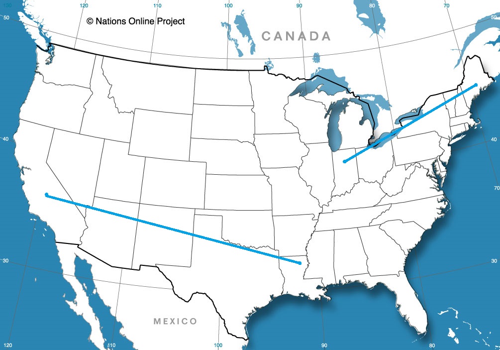
Tonight we embark on a 1,500 mile trip, from the Pacific Coast to the Big D. What weather will this weekend road trip encounter?? Let’s find out!
DAY ONE
As an upper-level trough shifts through the Pacific NW, an area of low pressure at the surface is developing over western WY and trailing a cold front of sorts back through the Great Basin. Luckily for us, all this activity is going to stay to the north of our Day One travels as we head east out of Oxnard through the northern LA Basin and then eastward on I-10 past Palm Springs and through the desert, eventually ending the day in Phoenix.
DAY TWO
It’s going to be a full day heading east on I-10, and better have those sunglasses because it’s looking like a pretty good day for traveling! There’s a slight chance of a few evening isolated thunderstorms, but those are just expected around the Big Bend area of the TX/Mexico border and should be off to the south of where we end our day in Van Horn, TX.
DAY THREE
I-20 is gonna be our home for the final leg of this stretch. It should be a pretty quiet day as we pass be Odessa, Midland, and Abilene. As we approach our final destination, there could be some widely scattered showers and thunderstorms as the tail end of a cold front shifts through the Red River Valley. Most activity should be off to the north over OK though, so odds are it’ll be a dry evening as we pull into Dallas!
Just to provide some context for just how big these United States are, we will be staying entirely west of the Mississippi and remain in states that border either the Gulf of Mexico or the nation of Mexico, and we will still be traveling 1,842 miles and taking 3 long days to get where we are going. We’ll even take interstates, so we’ll cover 68mph, and 546 miles per those first two days, and we’ll STILL have a lengthy 11 hour day to finish with.
Monroe, Louisiana
DAY ONE (Wednesday) There is a stout ridge of high pressure in the southeastern United States, and most of the precipitation for the next couple of days will be ridge riding on the north side of this dome, meaning very hot, dry and mostly sunny weather in the southeast, including in Louisiana and east Texas. The western edge of this dome will be in west Texas, but we will stop in Childress, before we run into the associated showers and thunderstorms. Hopefully, the AC works in the hotel.
DAY TWO (Thursday) As is the nature of shower activity on the backside of high pressure, it won’t be moving anywhere, but it’s coverage will probably expand through the day on Thursday. Expect some showers and storms through Amarillo, and as we cross into New Mexico, rain will lighten, but persist. In fact we may see rain persist right up to Tijeras, butting up against the foothills of the mountains surrounding Albuquerque. We’ll be in the clear, however, by the time we reach New Mexico’s biggest town, and will drive in sun to Manuelito, just before the Arizona line.
DAY THREE (Friday) High elevation rain showers may encroach the hills east of Manuelito, but that will be the only threat for this long finishing day of our trek. Strong low pressure is going to develop in the Rockies, kicking up a Santa Ana wind that may necessitate a firm grasp of the steering wheel. particularly as the day reaches it’s final stages, and we turn north into the San Joaquin Valley. Fresno will be mild and could be fairly breezy.
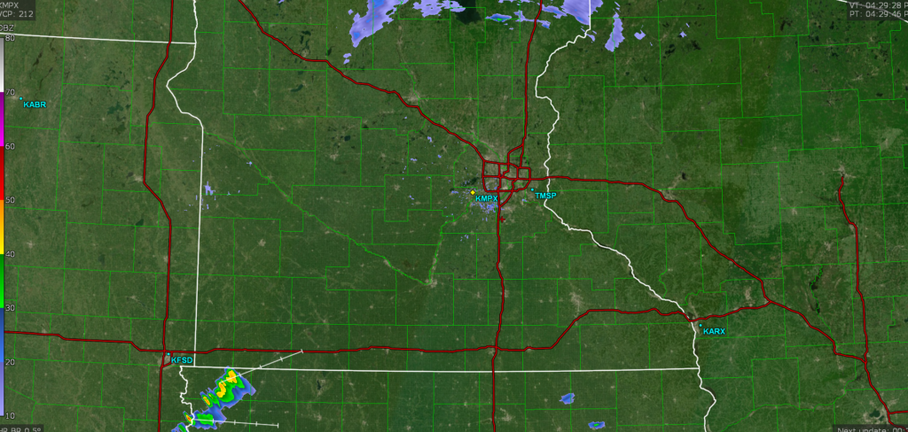
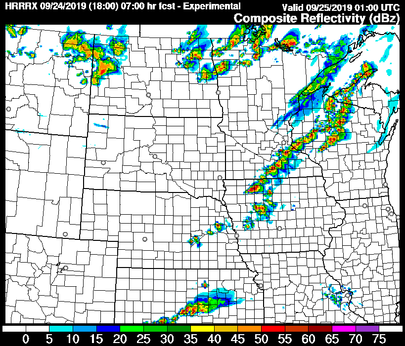
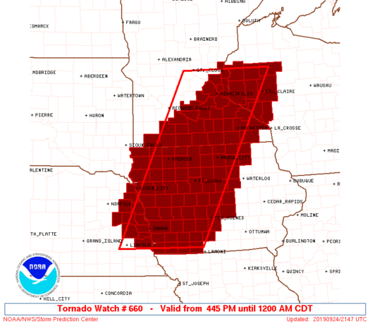
There is an enhanced risk for severe weather today in Minnesota, though at present, the radar is pretty sparse, save for a few showers in northern Minnesota and the first severe storm in northwest Iowa.
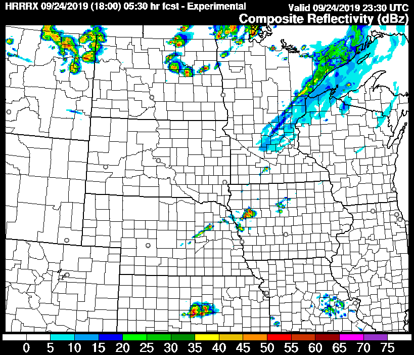
This radar imagery is from about 4:15. Here is a look at the HRRR forecast radar for about 630 this evening.
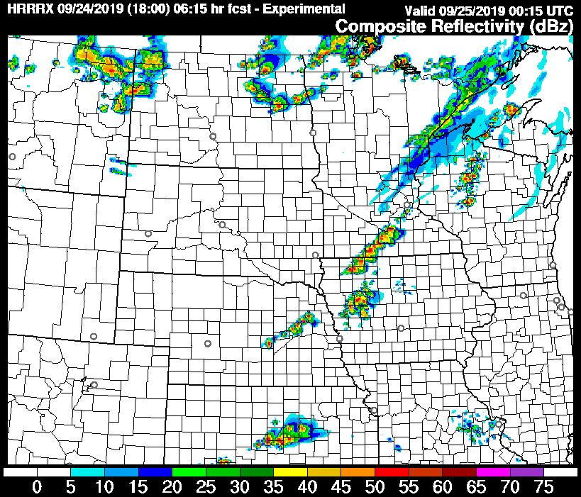
It looks as though the guidance is a little behind schedule, but the most important thing to note, will be how fast this line develops. This is the forecast radar 45 minutes later, or 715.
This looks like a strong line from Mankato to Storm Lake. Note the distinct blobs within the line. The threat for tornadoes and large hail is real tonight, and it is evidenced by the depiction of discrete cells within this line.
Eventually, and only within another 45 minutes, the storm will metastasize into a line. It will still be strong, and straight line winds will be added to the mix of threats.
This is the epitome of the “pay attention to the skies” days in southeast Minnesota and northern Iowa. Strong, dangerous storms are likely tonight, and they are likely to develop rapidly. It is possible that strong storms can develop and produce tornadoes even between radar scans with rapid development such as this.
Stay alert, heed local warnings, and listen to your gut. If it seems dangerous, take shelter, even if a warning has not yet been issued.
*Even as I was writing this, a tornado watch was issued for the region*
Meteorologists everywhere feel a twinge of guilt and pain every time severe weather targets life and property. We all love the weather, but when it turns ugly, it hurts a little differently, like we have somehow been betrayed. It’s worse when the bad weather is somewhat unanticipated.
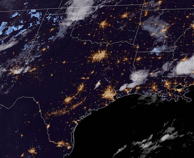
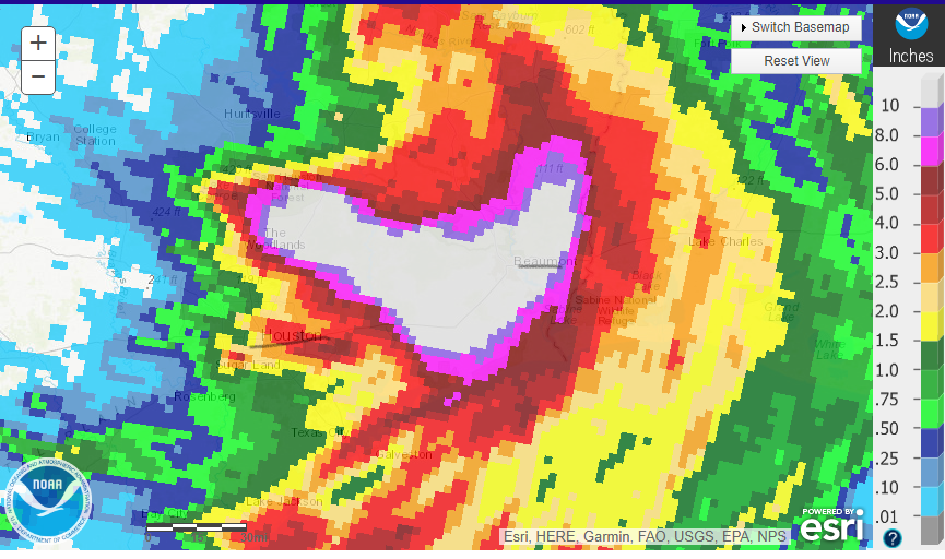
Imelda was never anticipated to be a strong storm, in terms of central pressure, or wind speed, and it wasn’t anticipated, originally, to linger very long. Eventually, the storm did slow down and tracked over the same tract of land for about 48 hours. The result is images that resemble those from Hurricane Harvey, particularly between Houston and Beaumont.
Here is a look at the heaviest rain of the past 24 hours. There is a swath from the Woodlands in the east Houston metro to Beaumont that saw 10+ inches of rain today. Over the course of the storm, that same area saw close to 2 feet.
I’ve underlined Houston and Beaumont on the map which should show you something else from a couple of different perspectives. Either you will see this map, depending on your perspective. Either you will note that the is a lot of rain for a very large area, or you will note that this is actually a lot less rain than the area saw with Harvey. Both conclusions are true, and should be telling.
Even though there is quantitatively less rain from Imelda, there was a lot of rain for a very large area IT was disruptive, deadly, destructive and evocative of the all time crisis that Harvey brought. This should underscore just what a nightmare Harvey was, but also sound an alarm about the eminent threat of any tropical feature. Just because Imelda’s torrential rain affected a smaller footprint doesn’t mean it wasn’t a major catastrophe. Imelda didn’t bring 5 feet o rain, but 2 is still pretty overwhelming.
Usually, when you think of mountains, you think of snow capped peaks and chilly air. In Greensboro last week, they were directly responsible for temperatures not cooling off as quickly as it could have. cold air was rushing south from the Great Lakes, but got hung up in the mountains. Southerly flow with humid air produced clouds and a bit of rain that certainly allowed for a cooldown, but not quite on the order forecast by our model guidance for Friday. Weatherbug had a blend of a good temperature forecast, and were one of only three that had rain in the forecast on Thursday. Actuals: Thursday – .01 inches of rain, High 95, Low 72 Friday – .01 inches of rain, High 82, Low 72
Before we begin, I want to highlight just what a miserable several days it’s been in southeastern South Dakota. Three EF-2 tornadoes embedded in a strong squall line tore through the south side of Sioux Falls, the state’s largest city Tuesday night. The massive devastation goes to prove, once again, that these strong squall events should be taken very seriously, because these tornadoes were so quick and briefly on the ground, they were over almost as soon as they were detected on radar.
The heaviest damage seemed to occur in one of the main commercial areas of the city, passing through a shopping center and a mall parking lot, and most noticeably tearing to shreds an Advanced Auto Parts. The City of Sioux Falls added this drone footage to their Twitter feed.
Here's a first look at the severe storm damage that occurred last night in Sioux Falls. pic.twitter.com/WyozEC0b8Q
While the tornadoes were embedded in a squall line, the squall line was a part of a persistent pattern of wet weather, that brought massive flooding to southeastern South Dakota and southwest Minnesota. Large tracts of I-90 were closed west of Sioux Falls to Mitchell, and many towns, including Madison, were cut off from the outside world by the rising rivers and creeks in the area. Many places received a foot of rain in a 72 hour period, and the region will remain wet this week. Let’s hope for better days soon.
As for the forecasting in the month of October, WeatherNation’s strategy of associating closely with the Weather Service and changing course only when necessary really only works if you find those situations where you can add value on your own. Well, in August, they did. Not only did WeatherNation win the forecasting title, the NWS dropped all the way to third. Congrats to WeatherNation. (Charts below are for daily forecasts)