Spokane, Washington

Another stop in our western sojourn as we travel to Spokane. It’s definitely one of our most frequent sites, so hopefully we will have little bit of experience on our side.

At 953AM, PT, Spokane was reporting a temperature of 42 degrees with overcast skies. Frost and freeze advisories were out for many of the cold-prone valleys in the Spokane region last night, but the overcast will prevent a significant cool down again tonight. Upper level low pressure is continuing to generate rain and even some thunderstorms, of which many will flare again this afternoon and evening. The persistence and future distention of the low is leading to diminishing returns for the storms, thought a few days ago, this system was capable of tornadic development.
the primary surface feature related to this trough has moved off to the Canadian prairies, but baroclinicity remains in place over the Pacific Northwest. At the base of the trough, another area of circulation is developing off the coast of Crescent City, California, and this should blunt the cool weather a bit, but the tandem lows and upper trough will hold cloudy conditions in place. Stronger and more well organized low pressure will emerge with the support of a reanimated lobe of the upper trough over the Gulf of Alaska. While this system advances the circulation off the coast will break down, and for a brief moment, clearer skies will be possible in Spokane, before Thursday sees a return of precipitation.
Tomorrow – Mostly cloudy, High 57, Low 35
Wednesday – Partly cloudy, High 59, Low 34

TWC: Tomorrow – Sunny, along with a few afternoon clouds. High 59, Low 36
Wednesday – Plentiful sunshine. High 61, Low 36

AW: Tomorrow – Cool with variable cloudiness High 58, Low 36
Wednesday – Sunshine mixing with clouds High 60, Low 36

WB: Tomorrow – Partly cloudy. Widespread frost in the morning, High 57, Low 36
Wednesday – Sunny, areas of frost, High 60, Low 36

WN: Tomorrow – SITE IS DOWN

FIO: Tomorrow – Partly cloudy throughout the day. high 60, Low 36
Wednesday – Clear throughout the day. High 63, Low 35

Wow, we haven’t had a website go down in a long time. I’ve looked through multiple browsers and devices but now luck. Chilly in eastern Washington for our forecast, and not a lot of the country can say that this week.
San Jose, California

I was in Costa Rica just two months ago. The capital and largest city there is also called San Jose, though I suspect the forecasts to begin this week will be a hair different.

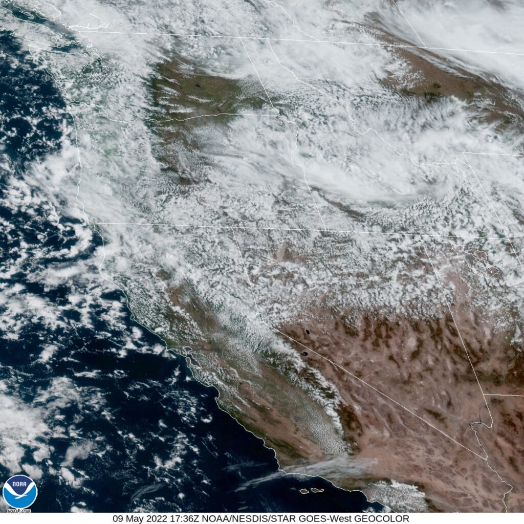
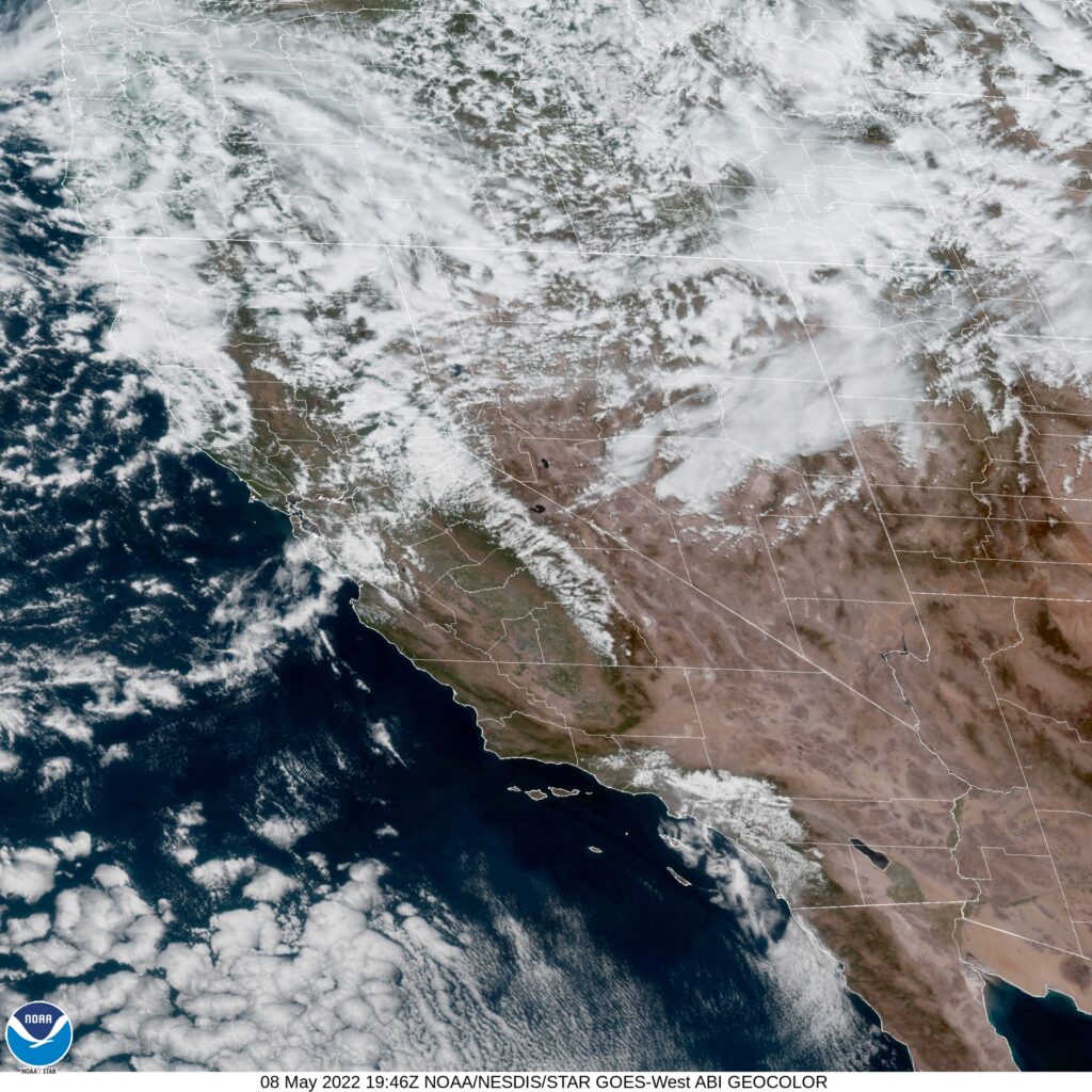
AT 753PM, PT, San Jose was reporting partly cloudy skies with a temperature of 54 degrees. Low pressure in the Pacific Northwest is extending a cold front being reflected at the surface approaching Victorville, while a band of clouds is streamed across the San Jose area. Brisk northwesterly winds give evidence that the boundary is through the region already. Heavy snow is expected in the higher terrain in Northern California as the upper level trough remains entrenched and moisture abundant.
As ridging strengthens in the middle of the country, the upper level trough will contort and dig deeper across the Bay area. Precipitation will become less likely, as a deeply distended trough in the northwest has less access to moisture, but unseasonably cold temperatures will be on the order for Silicon Valley, accompanied by blustery winds.
Tomorrow – Mostly cloudy, High 60, Low 45
Tuesday – Mostly cloudy, High 60, Low 45

TWC: Tomorrow – Mostly cloudy skies early will become partly cloudy later in the day. High 63, Low 46
Tuesday – Sunshine along with some cloudy intervals. High 63, Low 45

AW: Tomorrow – Cool with times of clouds and sun High 62, Low 47
Tuesday – Partly sunny and cool with a shower in places High 63, Low 45

NWS: Tomorrow – A 20 percent chance of showers after 11am. Mostly sunny, High 62, Low 42
Tuesday – A 20 percent chance of showers. High 63, Low 41

WB: Tomorrow – Partly cloudy. A slight chance of showers in the afternoon. High 61, Low 46
Tuesday – Partly cloudy. A slight chance of showers, High, 62, Low 46

WN: Tomorrow – Partly cloudy with light rain showers, High 63, Low 43
Tuesday – Partly cloudy with isolated showers, High 63, Low 41

FIO: Tomorrow – Partly cloudy throughout the day. High 61, Low 47
Tuesday – Clear throughout the day. High 64, Low 45

A wide array for you to choose form. Who will be right in the end? Satellite shows chaos to the north, and one defined boundary in California.

Inescapable gloom

It’s been a long, tough end to the cold season in the Upper Midwest for fans of warmer conditions. May started with more bad news for sunbathers of Omaha. After a storm system dipped south of Nebraska’s largest town, the clear air never forced its way in. Instead, the cold air behind the system settled in, and there was no way to heat it up, thanks to a persistent layer of clouds that lasted through the forecast period. Generally speaking, forecast outlets were more optimistic than what the situation called for. Weatherbug tends to have the chilliest forecasts, and the weather in Omaha played to their advantage on this occasion.
Actuals: Tuesday, .06″ of rain, High 53, Low 41
Wednesday – High 54, Low 48

Grade: C-D

April forecaster of the month

I’m as shocked as you are to see that I am able to put together this award ceremony in a mostly timely manner. It features a return of last year’s overall champion to a spot at the top. I have to commend Weatherbug on their growth through the years. Very often, they were tied to a Weather Channel forecast, and made changes with deleterious results. Now, in 2021, and at least in April 2022, they seem to have figured things out. Congratulations, Weatherbug!

OutletForecast Wins (year)
National Weather Service3.5
Accuweather2.83
Victoria-Weather2.33
Weatherbug2
The Weather Channel1.83
WeatherNation0.5
Forecast.io

Omaha, Nebraska

Omaha seems an interesting place to forecast for, given recent outlooks for the region. While today, the severe threat is to the south, if it stays there remains to be seen.

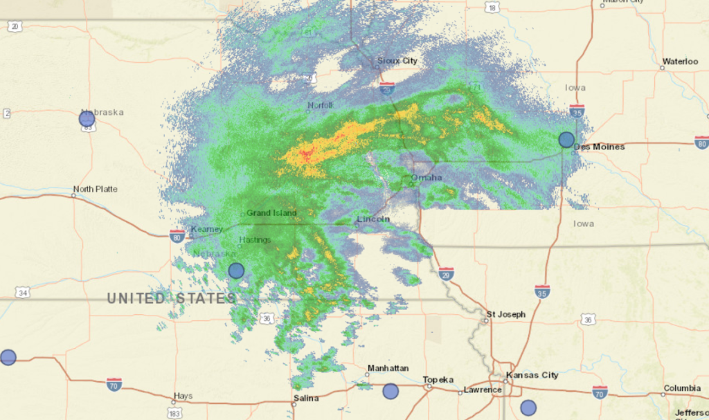
At 252PM, CT, Omaha was reporting cloudy skies with light rain with a temperature of 44 degrees. Brisk easterly winds persisted throughout the region, and worked mostly to hold the heaviest rain at bay, at least for the time being. A band of persistent rain showed on radar from Denison, Iowa to Columbus, Nebraska, and would eventually sink through Omaha tonight, A short wave moving through the central Plains had sunk closer to Kansas City, and the coldest, wettest shot was moving through the Omaha region.
This very same system is causing some wet snow in the western part of Nebraska, but it doesn’t seem like enough cold air will cycle far enough to the east for that to be an issue in Omaha before the precipitation wraps up. The short wave means this system is moving fairly quickly, even if the rain training across the region makes that seem counterintuitive. Things will dry out fairly abruptly overnight, with mostly cloudy skies by tomorrow morning. The next shortwave is already presenting itself in the Pacific Northwest, and will approach Omaha by mid week. Tuesday will largely be unseasonably cool but pleasant, while the next round will increase the clouds on Wednesday. An inverted trough could bring light rain to the region on Wednesday afternoon, with the full brunt of the feature waiting until Friday morning.
Tomorrow – A bit of rain before sunrise, then clearing. High 61, Low 43
Wednesday- Clouds increase with a spot of rain late, High 62, Low 45

TWC: Tomorrow – Cloudy skies early, followed by partial clearing (early rain) High 60, Low 41
Wednesday – Cloudy. Slight chance of a rain shower. High 63, Low 41

AW: Tomorrow – Cool; cloudy in the morning, then clouds and sun in the afternoon (AM Rain) High 59, Low 41
Wednesday – Intervals of clouds and sunshine (PM rain) High 63, low 42

NWS: Tomorrow – Cloudy, then gradually becoming mostly sunny (Early rain), High 60, low 43
Wednesday – A 40 percent chance of showers after 1pm. Mostly cloudy, High 61, Low 44

WB: Tomorrow – Decreasing clouds, late rain, High 56, low 41
Wednesday – Mostly cloudy, a chance of showers in the afternoon. High 59, Low 44

WN: Tomorrow – Partly cloudy with isolated showers, high 60, low 42
Wednesday – Mostly cloudy with scattered showers, High 62, Low 42

FIO: Tomorrow – Rain overnight and in the morning.High 59, Low 41
Wednesday – Rain in the evening and overnight. High 62, Low 41

Happy 40th birthday to the Weather Channel! here is a look at the radar from the Omaha region. Very busy!

Nice shooting

have you ever seen those paper targets after really good shots are done, and the holes are all pretty close to the center of the target? That was like our forecast in Baltimore. Everyone got an A on the forecast rating, thanks to high pressure, and no funny business. Clouds rolled in last Monday exactly as they were supposed to. The top forecast went to Weatherbug, who was nearly spot on.
Actuals: April 25th, High 78, low 53
April 26th, Hight 69, Low 53

Grade: A

Coming soon…

Now that all of the Justin Timberlake jokes and meme’s are out of the way, let’s get into one of my favorite months of the year.

San Jose, California

Spokane, Washington

Rocky Mount, North Carolina
Road Trip from Spokane to Rocky Mount

Duluth, Minnesota

Kokomo, Indiana
Road Trip from Duluth to Kokomo

Dangerous weather through the weekend

The weather has certainly been active this spring, and especially so if you consider how busy the Storm Prediction Center has remained since December of last year. Fortunately, since the devastation wrought in western Kentucky, southern Illinois and many places surrounding, we haven’t seen the type of devastation that stays in headlines for days.

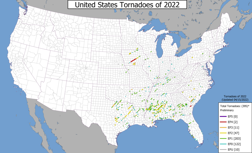
That’s not to say the storms have been any less violent so far this year. In fact, there was an EF-4 tornado last month that swept through Winterset, Iowa, claiming the life of 6. That was as strong as the Mayfield, Kentucky tornado. The substantive difference is that Winterset is not as large a town as Mayfield, but the Winterset tornado also did not have as long a track as the western Kentucky storm.

A look at the tornado tracks this year show that, while there have indeed been many twisters this year, most of them were weak, and a lot of them were in Dixie Alley.

By Supportstorm – Own work, CC0, https://commons.wikimedia.org/w/index.php?curid=115162410

By and large, those storms are avoiding the largest population centers, and haven’t been particularly virulent, as tornadoes go.

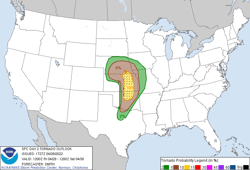
The pending change is twofold. First, tomorrow, the threat for significant weather targets an area including Tulsa and Wichita. Over the weekend, the threat includes the Dallas Fort Worth area. In general, the storms are going to affect a more populated area. Second, the storms are going to possess a notably higher threat for strong tornadoes. The hatched area in the SPC’s outlook for tomorrow indicates a threat of large (EF-2 or greater) tornadoes in an area. Those are big twisters dangerously close to Kansas City and Oklahoma City, potentially.

Big storms in more populated places remind us that we are definitely in severe weather season, and it is time to keep an extra eye on the sky.

Baltimore, Maryland to Racine, Wisconsin

Spring is supposed to be here. Really, it should be right around the corner. Why not drive to the lake? Specifically, this day and a half trip will cover the 776 miles between Chesapeake Bay and southeast Wisconsin. We will make the journey at a pace of 60.3mph. Thanks side streets and Chicago! The first day drive will cover 482 miles, leaving that Chicago chunk for day two.

DAY ONE (Thursday)

Baltimore, Maryland

The cold air in pursuit of an offshore cold front is going to cycle through New England and the mid-Atlantic tomorrow, likely pressing some mid and low level clouds through the undulating terrain of Pennsylvania. Light rain looks to be suppressed by local high pressure, and moisture is getting drawn towards a developing lee trough. Cloudy and cool, then, until we get to the toledo area and call it a night.

DAY TWO (Friday)

A warm front will be working it’s way north throughout the day on Friday, starting, I suppose, even on Thursday. Moisture will be penned closer to the Mississppi and the Illinois-Missouri border as we pass through Chicago, though a DEFCON 1 rain shower can’t be ruled out as we navigate the Windy City. It’s going to rain this weekend in Racine, but it probably won’t be when we arrive.

Baltimore, Maryland

I’ve been to Baltimore a couple of times. I saw Oriole Park and the Inner Harbor, and both were a joy. What about the weather, will that be as joyful?

At 1154PM, ET, Baltimore was reporting a temperature of 59 degrees. Clear or fair skies were reported across the mid-Atlantic, with a high amplitude ridge along the coast, merging, but not quite fully in phase, with a strong Bermuda High.
Seasonably strong storm features spun south of Newfoundland, and again over the Upper Midwest, and were connected by mid and high clouds in New England, showing off where the jet structure was strongest. The cold front with the trailing system will press eastward into the ridge, breaking down both the front and the ridge. Clouds will become more likely, as will some coastal haze, which will keep temperatures in check to start the work week.
Tomorrow – Sunny, High 77, Low 55
Monday – Clouds likely, High 70, Low 54

TWC: Tomorrow – Generally sunny High 80, Low 53
Monday – Mostly cloudy skies High 71, Low 54

AW: Tomorrow – Partial sunshine High 79, Low 54
Monday – Intervals of clouds and sun High 70, Low 54

NWS: Tomorrow – Patchy fog before 8am. Otherwise, mostly sunny, High 77, Low 53
Monday – Patchy fog before 11am. Otherwise, partly sunny High 70, Low 54

WB: Tomorrow – Mostly sunny, High 78, Low 53
Monday – Patchy fog in the morning, High 68, Low 53

WN: Tomorrow – Mostly sunny, High 77, Low 54
Monday – Partly cloudy High 70, Low 54

FIO: Tomorrow – Clear throughout the day. High 77, Low 51
Monday – Overcast throughout the day. High 70, Low 53

Head on over to WBAL to see friend of the Blog Tony Pann give the forecast for Baltimore, noting the wide variety of temperatures across Maryland tonight.