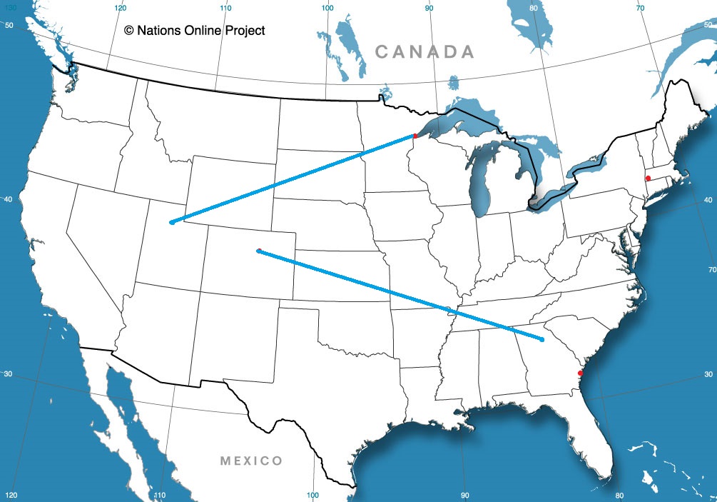
Google recommends two routes between Ogden and Duluth. One of them only has Fargo as the largest town between the two destinations. We’re going to take a more southerly route, in which we will pass through the Twin Cities. It’s a little less lonely. The drive will take 2 1/2 days and cover 1381 miles. Our pace will be 67.1mph, which means that the first two days will intend to conclude after 536.7 miles. Hope you like country music, because I bet there isn’t much else on the radio.
DAY ONE (Friday) The worst place to get stuck in the weather is the mountains. Slick roads plus climbs and drops and it can get a little dicey. Well, we are in Utah, and they don’t like dice. There will be high pressure in the northern Rockies tomorrow, holding a developing area of low pressure up in Canada while it warms up along our route. We will get to the sleepy eastern Wyoming town of Mule Creek, which is north of Lusk.
DAY TWO (Saturday) Another advantage to the southern route, aside from seeing actual human beings, is that the area of low pressure moving through Canada won’t carry enough cold air or momentum to intercept us as we pass through South Dakota or southwest Minnesota. We’ll make it to Mountain Lake, Minnesota with dark clouds with no rain on the northwestern horizon as we end the day.
DAY THREE (Sunday) If there is any precipitation with the passage of this cold front, it will be overnight as we recline in Mountain Lake. The cold front will be through southern Minnesota, so cool conditions will return as we head towards Duluth. Duluth is a very nice town, and because of Lake Superior it is always a little cool. Bring a jacket!
It’s the middle of April, and, disgusting though it may sound, we can’t officially exclude snow from the forecast. Not without a thorough examination, anyway.
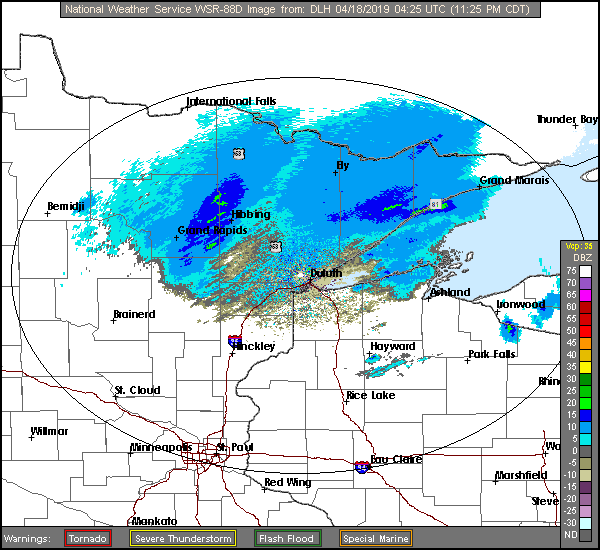
At 416PM, CT, Duluth was reporting a temperature of 41 degrees with drizzle and a brisk northwest wind. The temperature across the border in Superior, where wind was more directly coming off the Lake of the same name, was only in the mid 30s. No snow is presently being reported in northwest Wisconsin, but it is certainly not out of the question as cold air continues to filter in. Low pressure will track from southeast Minnesota, through central Wisconsin and into northern Michigan, which will be near enough to Duluth that cold air won’t really sneak in until late in the game. There will be a little bit of leftover moisture overnight when the temperature profile is most likely to permit snow in the early morning hours tomorrow. There will be a quiet period Thursday afternoon, followed by a very pleasant day on Friday. An area of low pressure moving through northern Saskatchewan will drag warmer air north by Friday evening. Tomorrow – Cloudy with drizzle in the morning, then sunny, High 51, Low 37 Friday – Sunny and warmer, High 60, Low 36
TWC: Tomorrow – Cloudy with light rain early. Snow may mix in High 51, Low 36 Friday – Sunny skies High 56, Low 31
AW: Tomorrow – Mostly cloudy, a brief shower or two, High 49, Low 36 Friday – Mostly sunny; not as cool High 56, Low 33
NWS: Tomorrow – Rain likely before 7am, then showers likely, mainly between 7am and 2pm. Mostly cloudy, High 49, Low 37 Friday – Sunny, High 57, Low 32
WB: Tomorrow – Mostly cloudy. ain showers likely in the morning then a chance of rain showers in the afternoon, High 51, Low 38 Friday – Sunny, high 57, Low 33
WN: Tomorrow – Mostly cloudy with light showers likely, High 48, Low 37 Friday – Sunny, High 57, Low 32
FIO: Tomorrow – Mostly cloudy throughout the day. High 54, Low 40 Friday – Partly cloudy overnight. High 63, Low 36
Forecast.io went way warmer than the rest of the group, suggesting faith in model guidance. Makes sense since it is a computer algorithm. I captured the radar much later than I started the forecast, but there is still a bit of light rain in the Arrowhead of Minnesota.
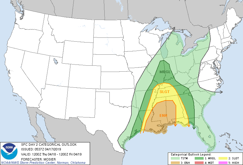
Generally speaking, Tornado Alley is at its most active during the late spring and early summer. The most treacherous tornadoes in Oklahoma’s history have all seem to come in the first week in May, for example. Here in 2019, however, we have been reminded that the so called “Dixie Alley” sees its busiest time in the early part of spring.
We’ve already seen the deadliest tornadoes in 6 years on March 3rd, as a twister in Beauregard, Alabama killed 23 people there alone. Earlier this week, destructive tornadoes rumbled from Franklin and Alto, Texas to Vicksburg, Mississippi.
This pattern is expected to continue in the next couple of days. There is a chance for strong thunderstorms today in the southern Plains, a bit further west than what we have seen so far, but tomorrow poses a risk for a return of severe storms, with an emphasis on tornadoes in Dixie Alley. There is an enhanced risk for severe storms from Louisiana to Georgia and the Panhandle of Florida.
The jet stream hasn’t quite retreated to Canada yet this early in the season, so surface moisture doesn’t build all the way back to the Plains. Cold air is more dense and has more momentum than warm air, so it has no problem intruding on the southeastern US, touching off the strong storms of early spring.
It will get a little bit further away, that cold air, as the summer approaches and finally arrives. The severe threat in the southeast will lessen, but the oppressive heat and humidity will certainly arrive.
We’ll touch upon the storms that have swept through the south, in particular east Texas and the Lower Mississippi Valley soon, but in a less important note, gosh darn it it rained in Hattiesburg on Tuesday morning. It wasn’t much. Nobody noticed it because it was so brief and pre-dawn, but forever on the record it will say it rained on Tuesday April 9th, 2019, and nobody will remember it or acknowledge it, because it was a trace of rain in a week that saw the area get pummeled by more concerted rounds of stormy conditions. on Monday and then again over the weekend. All of these complaints are to say that Victoria-Weather didn’t do greater with the forecast. The National Weather Service and WeatherNation did, however, winning the day. Actual: Tuesday -Trace of rain, High 81, Low 62 Wednesday – High 82, Low 56
Well, we finished this week off with a pretty nasty system in the south central US, and the next few days don’t look any less active. Where will we dispatch from in the next several days?
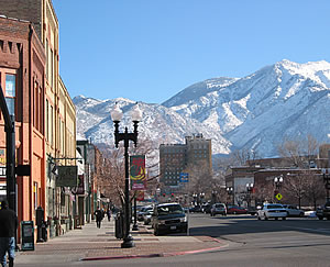
Duluth, Minnesota Road Trip from Ogden, Utah to Duluth
Texarkana was named after three states it is near. It straddles the Texas-Arkansas border, and isn’t far from Louisiana. Sure, it’s closer to Oklahoma, but Texarklahomana is unwieldy.
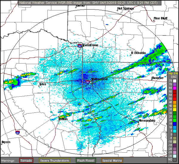
At 953PM, CT, Texarkana was reporting a temperature of 59 degrees with clear skies. An oscillating boundary over the region is beginning to pivot back north as an area of low pressure develops over the Big Bend area of Texas. The front had pushed south, associated with a strong system now north of the Great Lakes, but the base of the parent trough is over Texas, and fostering development at the tail of the original front. Texarkana looks to be directly in the line of fire for some strong weather tomorrow. Heavy rain with strong thunderstorms will be possible throughout the day, with the best chance coming in the late morning. Because the activity is expected to arrive so early, Texarkana may avoid a particularly tough fate, which is more likely to the southeast, where a “Moderate Risk” of severe weather is being forecast. The dynamics of the system, particularly the inherent vorticity and widespread instability suggest that this storm could result in a large tornado outbreak. Overcast skies and the chance for light rain will continue through the early morning on Sunday, but clearing skies will arrive by lunch time and continue for the remainder of the weekend. Tomorrow – Rain with strong thunderstorms, High 64, Low 56 Sunday – Scattered showers early, then clearing, High 62, Low 45
TWC: Tomorrow – Variable clouds and becoming windy with strong thunderstorms. Damaging winds, large hail and possibly a tornado with some storms. High 59, Low 56 Sunday – Cloudy skies early, then partly cloudy in the afternoon. High 64, Low 45
AW: Tomorrow – Rain and severe thunderstorms; storms can bring flooding, hail, damaging winds and even a tornado High 64, Low 56 Sunday – Some clouds, then sunshine; breezy and cool High 61, Low 45
NWS: Tomorrow – Showers and thunderstorms. Some storms could be severe, with large hail and damaging winds High 65, Low 56 Sunday – A 20 percent chance of showers before 1pm. Cloudy, then gradually becoming mostly sunny High 62, Low 47
WB: Tomorrow – Showers and thunderstoms. Some thunderstorms may be severe with damaging winds, large hail and tornadoes in the afternoon. High 59, Low 57 Sunday – Mostly cloudy with a 20 percent chance of showers in the morning then partly cloudy in the afternoon, High 61, Low 47
WN: Tomorrow – Cloudy with heavy thunderstorms, High 65, Low 56 Sunday – Partly cloudy with isolated showers, High 62, Low 47
FIO: Tomorrow – Rain starting overnight and windy starting in the morning, continuing until afternoon. High 59, Low 55 Sunday – Mostly cloudy until evening. High 64, Low 45
Here is a look at radar imagery of banded showers across the Ark-La-Tex. Below is a Facebook live event from Todd Warren, a meteorologist out of of NBC in Texarkan/Shreveport looking at the severe threat for tomorrow.
Well, the weather hasn’t been too great up here in the Upper Midwest last couple of days. Constant periods of snow and sleet and strong winds have made for an unpleasant week. While our weekend looks to be dry but cold, let’s go see what it’s like in the Southern US. Like WAY far south. Laredo in fact! Any further south and you’d need a passport.
At 856pm CDT, the temperature at Laredo, TX was 77 degrees under fair skies. Tail end of a stationary front is lingering over the TX Gulf Coast, but is expected to retreat northward during the day tomorrow. An area of low pressure is expected to intensify over West TX from morning throughout the day as it shifts eastward. By midday, the low will be centered near Dallas while the accompanying cold front will have swept eastward through the state into LA, kicking off strong to severe weather over LA into AR. As far as the Laredo area is concerned, precip should stay off to the north as clouds are expected in the morning, but clears out by midday as strong winds from the west. Clear skies then expected throughout the rest of the weekend but with temperatures coming down a bit on Sunday in the wake of tomorrow’s system.
Saturday: Cloudy early, then clearing. High 86, Low 67.Sunday: Clear, slightly cooler. High 81, Low 55.
TWC: Saturday: Partly cloudy, windy. High 88, Low 69.Sunday: Sunny. High 81, Low 52.
AW: Saturday: Windy in the afternoon. High 91, Low 68.Sunday: Mostly sunny: not as warm. High 80, Low 54.
NWS: Saturday: Sunny and breezy. High 90, Low 68.Sunday: Sunny. High 78, Low 55.
WB: Saturday: Windy. High 91, Low 70.Sunday: Sunny. High 80, Low 52.
WN: Saturday: Mostly sunny. High 90, Low 68.Sunday: Sunny. High 79, Low 56.
FIO: Saturday: Partly cloudy in morning and breezy in afternoon. High 89, Low 69.Sunday: Clear throughout the day. high 81, Low 53.
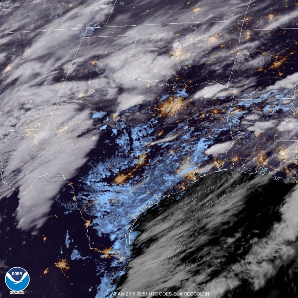
We see the storm system getting revved up over Western TX, while eastern TX is already seeing some low clouds cover the region
The forecast later in the week for Monroe, Michigan would become a little bit gloomier, but at the beginning of the week, there was only an isolated shot at some showers. It was warm, otherwise, with a lot of sun. More sun than expected, because those rain showers never materialized in Monroe, and temperatures warmed even more than expected. A warm forecast doesn’t usually mean Weatherbug has a horse in the race, but they did this time, claiming victory. Actuals: Sunday – High 64, Low 43 Monday – High 72, Low 55
It was a picture-perfect day around here in the Twin Cities. Upper 60s, partly cloudy, a little on a breezy side but wasn’t awful. These are the beautiful spring days that we cherish around here.
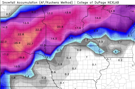
So of COURSE we’re looking at a monster snowstorm moving our way in 3-4 days. A low pressure system that’s currently moving onshore over the West Coast is expected to eject into the Plains on Wednesday and become another BOMB CYCLONE (it’s this year’s fun media-hyped weather buzzword, like Polar Vortex). Forecasts are, naturally, very wide-ranging in our area specifically, but it’s looking extremely likely that there will be a broad swath of land from western Nebraska to northern Minnesota that will get 12-18″ of snow, with embedded areas getting over 2 feet. Below is the latest GFS snowfall forecast through the event. It will be interesting to see how the system evolves over the next couple of days.
Just for reference, the biggest April snowstorm on record in the Twin Cities is 15.8″ set all the way back in… 2018. The 9th biggest storm of 9.0″ was also last year. This is not a trend I like to see continue, but alas, BUCKLE UP EVERYBODY. Winter is coming… well, I guess it hasn’t left at all.
After a quiet weekend, we are jumping back into the world of forecasting. Another big storm looms here in mid April, which is fine alongthe Gulf Coast, and might even be a little fun. Don’t ask about what it’s like up north.
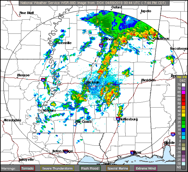
At 753PM, CT, Hattiesburg was reporting a temperature of 72 degrees and overcast skies. Central Mississippi was seeing an active weather night, as a clearly evident vorticity maximum centered southeast of Brandon was drawing a band of thunderstorms along I-59, however the southern end was pulling northeast and away from town. The air in the southeast is juicy and unstable, but the trough parenting this hit of low pressure has little upper level support and a lot of forward momentum. Expect a quiet night in Hattiesburg. And so it will be on Tuesday and Wednesday as upper level high pressure follows into Mississippi. Expect a brisk warm up on Wednesday as a beast of a system develops in the central Plains and taps into the Gulf of Mexico for moisture. Tomorrow – Mostly sunny, High 77, Low 63 Wednesday – Partly cloudy, warmer and more humid, High 85, Low 57
TWC: Tomorrow – A shower or two around the area in the morning, then partly cloudy in the afternoon. Thunder possible High 80, Low 61 Wednesday- A mainly sunny sky. High 86, Low 55
AW: Tomorrow – A passing morning shower; otherwise, mostly cloudy High 79, Low 63 Wednesday – Plenty of sunshine; warmer High 86, Low 54
NWS: Tomorrow – A 20 percent chance of showers before 10am. Cloudy, then gradually becoming mostly sunny, High 81, Low 62 Wednesday – Sunny High 84, Low 56
WB: Tomorrow – Mostly cloudy with a 20 percent chance of showers in the morning High 78, Low 63 Wednesday – Sunny, high 85, Low 55
WN: Tomorrow – Partly cloudy with isolated showers, High 81, Low 62 Wednesday – Sunny, High 84, Low 56
FIO: Tomorrow – Mostly cloudy until afternoon. High 80, Low 63 Wednesday – Clear throughout the day. High 86, Low 56
First, check out the radar, and the low pressure evident even on this map.
Now let’s check in with WJTV from Mississippi for the Pine Belt forecast.