Lee will take all week to reach land

It seems as though we have been talking about Hurricane Lee for a while now. It feels like the storm should already have blown past Bermuda. Instead, the storm is still northeast of Puerto Rico, and won’t really kick out of this area until Wednesday. At that point, Lee will relly start to move, and we will get a little more confident on where he will eventually landfall.

Right now, though, even a week out, there is a solid cluster of models that put his landfall near Yarmouth, Nova Scotia next weekend.

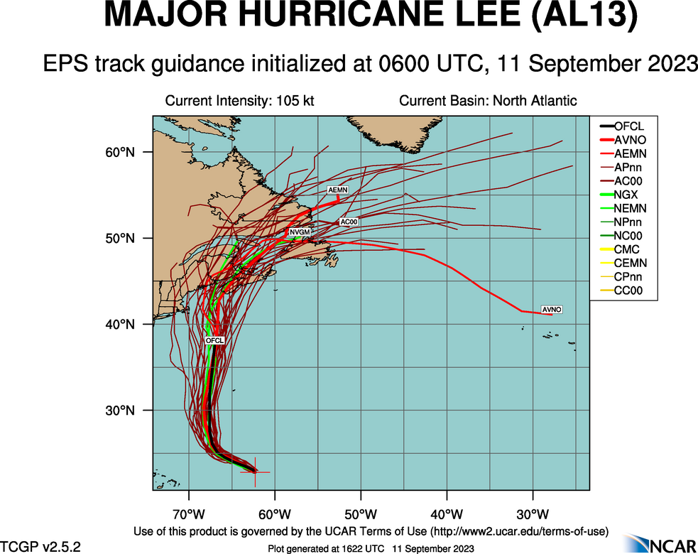
Late this week, he will pass to the west of Bermuda, but spiral bands of thunderstorms will certainly swipe at the island, and heavy surf is quite likely. As he passes Bermuda, he will be weakening, and by landfall, may be a Tropical Storm.

If he landfalls as a hurricane, it is because he does so further south and west – one of those stray strands of spaghetti indicating the storm could waiver and strike New England directly. As it is right now, Lee is still a strong storm that developed rapidly. As with every hurricane season, so much depends on luck, and luckily, there is steering flow to drive Lee away from the mainland just enough. Even as storms get stronger, that reliance or hope for good fortune remains the same.

Of course, a strong tropical storm landfalling in Nova Scotia is still noteworthy and not great news. Fortunately, southern Nova Scotia is regularly battered by strong storms, though not of tropical origin, which means the area, infrastructurally, can withstand a pretty decent pummeling. Where I am concern is if the storm orients just right, heading back northeast while driving water into the Bay of Fundy. In that scenario, surge could be a issue in New Brunswick and Truro, Nova Scotia.

More remains to be seen. Where will Lee ultimately decide to go? How swiftly will he start to deteriorate upon finding cooler waters? We still have a week to find out.

Before I go to bed

I will discuss this in greater detail tomorrow, but I want you to wake up with this knowledge. Hurricane Lee is not going to landfall in the States. I would worry more about that in Nova Scotia. Additionally, this does not mean that US interests on the coast are in the clear. As Lee heads to the north, be wary of rip currents and high surf as the stom heads north.

Heat prologue

Labor Day weekend was very hot for the middle of the country, but it took a little bit of ramping up. It wasn’t very warm yet when we forecast for Danville. The temperatures were on the rise, though, finishing at 86 on the 2nd, better than the 55 we observed to start the forecast on the 31st. Victoria-Weather took the W for Danville.
Actuals: September 1st, High 82, Low 54
September 2d, High 86, Low 54

Grade: C

An anecdote

To give you an idea of the weather scenario we are in right now, I was just on a conference call with people from many parts of the country. One of the attendees from Texas was lamenting the triple digit heat that continues to boil Texans.

Here in Minnesota, I had to wear a light jacket this morning. Fall is coming, people. Eventually.

Update: Brr!

Low pressure will try to deflect the next round of tropical weather

Lee, presently in the North Atlantic, already looking for a trip to the Eastern Seaboard, is a big, scary storm. He’s going to be a Cat 4 before all is said and done, and a Cat 5 is not out of the question. Fortunately, this is the forecast map for Saturday.

That coastal feature should be just enough to shunt Lee away from the coast. Remember that if you are lamenting the weekend rain out East this weekend.

August Forecaster of the Month

It’s been a long year for Accuweather. Coming into August, they still hadn’t had a solo win on a single forecast all year. August is through, and Accuweather still hasn’t won a forecast for themselves. They tied for the win on three this month, however, and that consistency earned them the Forecaster of the Month title.

OutletForecast Wins (year)
Victoria-Weather5.83
The Weather Channel4.83
Clime2.83
National Weather Service2.5
WeatherNation2.5
Weatherbug2.5
Accuweather2

A switch flips

On the 22nd, we put together a forecast for Trenton, where weather was looking fine. It continued as such for most of Wednesday the 23rd as well, but in the afternoon, things went from clear to cloudy in the span of a couple of hours, and then Trenton sat in the sludge for the rest of the forecast period. there was a little bit of rain that came with the overcast, which put Clime off of the victory, and instead handed it to the unlikely duo of Accuweather and Weatherbug.
Actuals: Tuesday August 23rd, High 78, Low 59
Wednesday – August 24th, .15 inches of rain, High 72, Low 66

Grade: B-C