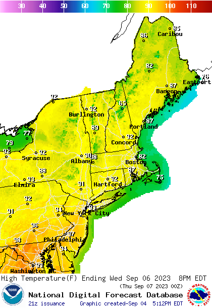
Hot weather is roasting the middle of the country on this Labor Day, but it’s going to break, at least in the northern part of the country thanks to a round of severe weather moving through the Upper Midwest. The peak of the heat for New England looks like it will come on Thursday of this week. Below are the highs for Thursday
We’ve spent some time looking at the temperature trends for September, including some outlooks for the temperature over the next few weeks. Also illustrative, though, is the severe weather outlook. Much cooler weather is coming behind the severe weather.
Additionally, with crops still in the ground, if things get cooler and clearer pretty quick, all that moisture will lead to some foggy mornings, further helping keep temperatures in check. It’s right around the corner.
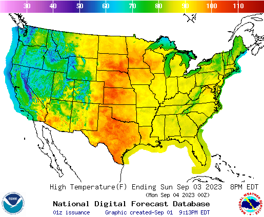
By now, I’m guessing many of you have assessed the forecast ahead of Labor Day as you make your holiday weekend plans. I hope it includes a pool, cold drinks or plenty of air conditioning. Not only is it expected to be warm, but expect record breaking heat through the center of the country. Here in the Twin Cities, triple digits aren’t out of the question.
While it will be a blast furnace from Wisconsin to the Dakotas and south through the Plains, it will be much more comfortable on the coasts, except, I should note, around the DC/Baltimore area, where it’s going to be abnormally warm as well.
After the weekend, the heat will ease a little bit, but it’s still going to be danged hot, especially for the areas surrounding west Texas. Note that the heat is also going to arrive in New England and the Mid-Atlantic.
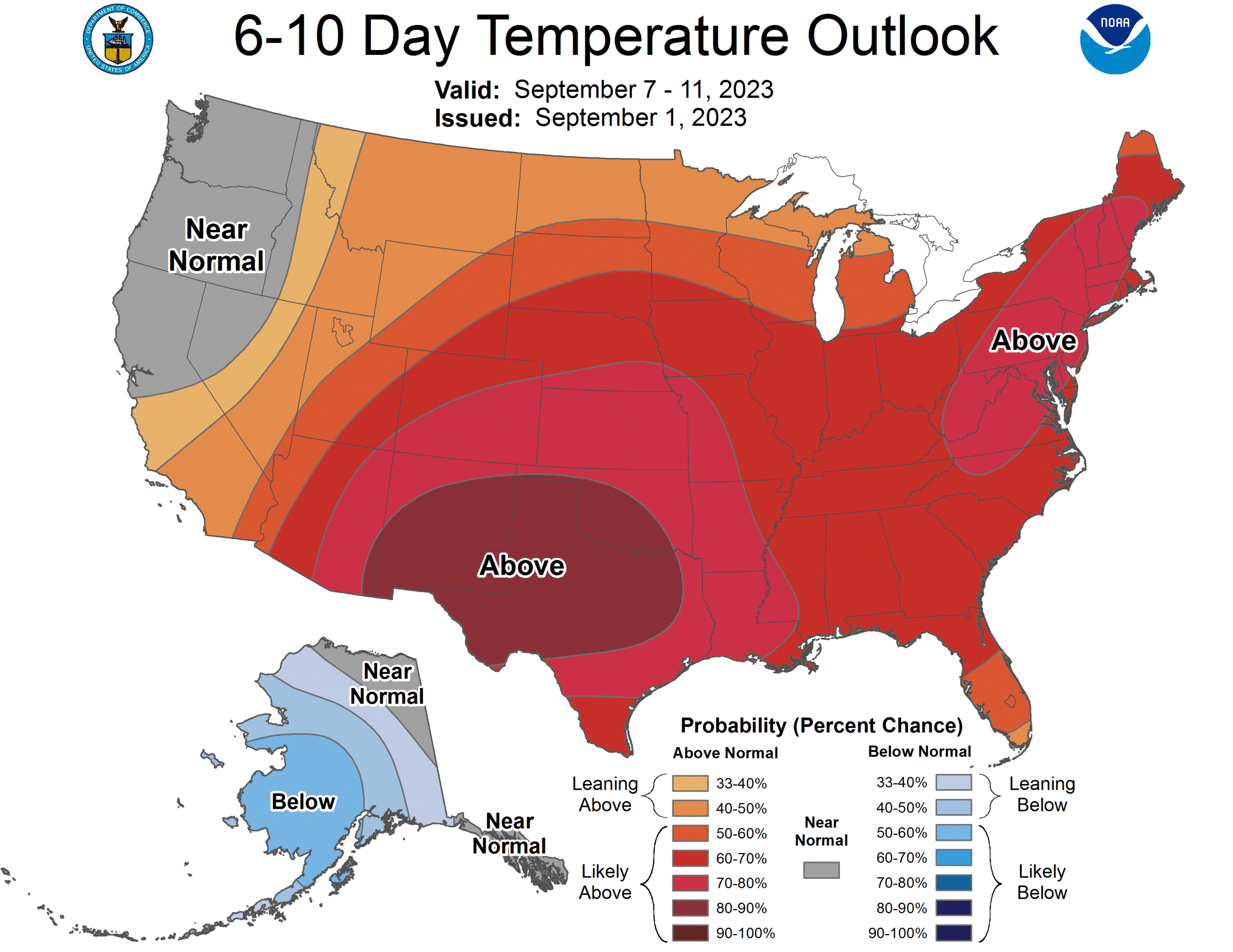
The rest of the month, after the 7th-11th looks to mostly temper. but still fairly warm. One bit of good news is that it looks wetter than normal in the Plains, which will stymie any growing drought concerns in the Plains.
I famously am constantly in need of an editor, someone to review my spelling, and in some cases, such as two weeks ago when I put together a forecast for Yuba City, California, to make sure I made any sense. I suggested that diurnal convection might feel “left out” and bring shade to the town, and said that it is “night” that we are seeing clouds instead of smoke on the satellite this summer in California. I even spelled night correctly. I published the forecast after midnight, Victoria-Weather time, which was a big part of the problem, but despite all that, we managed to have the best numbers for Yuba City, tied with The Weather Channel. High pressure in the area provided the clear skies (and left those clouds out) needed to bump temperatures right on up to 106 on the 15th. Maybe I just need to start writing more in the middle of the night? Actuals: Monday, August 14th, High 100, Low 74 Tuesday, August 15th, High 106, Low 67
Danville is south of Chicago and snuggled up next to Indiana. The whole region is consumed by corn fields.
At 959PM, CT, Danville was reporting a temperature of 55 degrees with fair skies. Dew points were in the low 50s as well, and thanks to the looming harvest, the air around Danville was a bit moister, and will be prone to fog on clear nights such as today. High pressure is currently in place, while Idalia in the Carolinas had started to pull some cooler moisture from Canada towards the low, bringing some cooler air to Danville. Temperatures will remain a bit suppressed while a wave moves just north of the Canadian border. Even though the system is bringing severe weather to the northern High Plains tonight, it will leave northern Illinois dry. After this feature shifts on, temperatures in Danville will really start to climb, just in time for the holiday weekend. Tomorrow – Mostly sunny, High 79, Low 50 Friday – Sunny and warmer, High 85, Low 50
TWC: Tomorrow – Mainly sunny High 77, Low 49 Friday – Sunny skies High 83, Low 52
AW: Tomorrow – Plenty of sunshine; a nice end to August High 78, Low 49 Friday – Nice with plenty of sunshine High 85, Low 51
NWS: Tomorrow – Sunny High 78, Low 49 Friday – Sunny High 83, Low 51
WB: Tomorrow – Sunny High 76, Low 50 Friday – Sunny High 83, Low 53
WN: Tomorrow – Sunny High 78, Low 49 Friday – Sunny High 83, Low 52
CLI: Tomorrow – Clear, High 77, Low 50 Friday – Sunny, High 82, Low 52
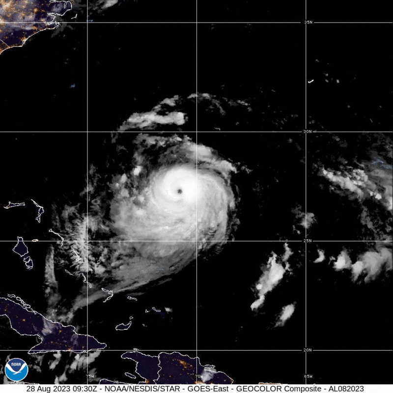
The GFS was much warmer than all other models for Danville, and nearly every outlett abandoned that guidance. The warmth is coming, just a matter of when. Here is the satellite, with Idalia in the southeast corner.
Idalia looks like she will make landfall tomorrow at about the spot that was expected before it even had a name. Initial model guidance wasn’t as aggressive on the storm’s intensification as the NHC was, so credit as always to the meteorologists, but here is the good news:
The Big Bend are of Florida is fairly sparsely populated. Storm surge, thanks to the geography of the region, will be quite high for Cedar Key north and westward, but there aren’t a lot of beachfront communities in the area. Not to say there aren’t any, but the most costly part of this storm will not be the surge, even though it will be impressive.
Instead, my biggest concern is the flash flooding that may come to places like Live Oak, Valdosta and Wenatchee. Sporadic tornadoes are also a big concern, as they usually are with landfalling hurricanes.
Idalia is a healthy storm, and will be memorable for those it impacts. The only reason this storm isn’t more fearsome is because it found the part of the Florida Coast that hasn’t been fully developed.
Franklin is a big beautiful storm, with a well developed eye that is mercifully spinning well away from most major interests, save for the air and sea interests of the North Atlantic. He is not getting much attention, because he isn’t going to make landfall anywhere, and will merely work to reroute aircraft and ships.
All that said, he is causing a trough in the mid-Atlantic to slow down, and the rain showers in the Virginias over the weekend dumped enough rain to cause some flash flooding over both states. As Franklin keeps moving, ultimately so will these showers. With luck, Idalia will also steer clear of the region.
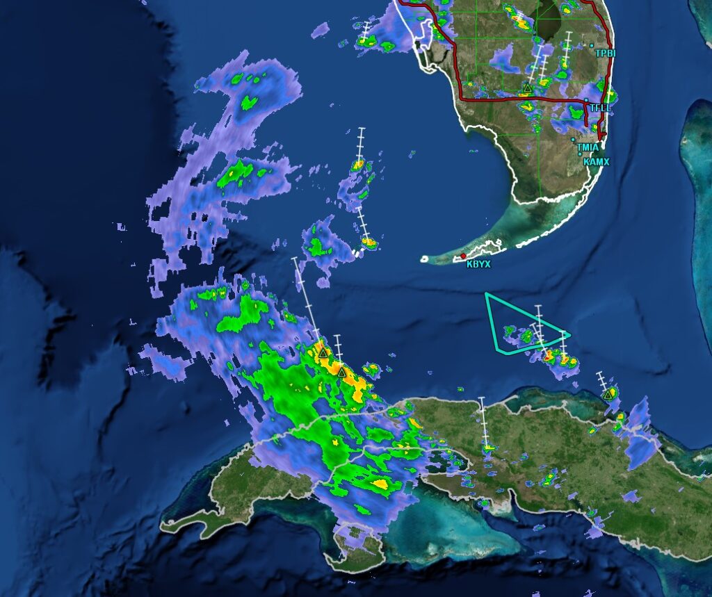
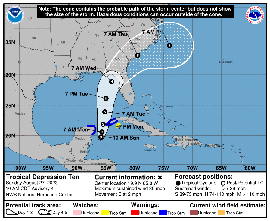
Idalia has formed off the Yucatan. There aren’t any major changes vs. what we were looking at yesterday, save for a little bit of acceleration. Expect the storm to landfall on Wednesday south of Tallahassee as a strong tropical storm.
UPDATE 9pm – The latest forecast from the NHC has Idalia landfalling at a Category 2 level. That seems a little high to me, but ultimately, what is most important is that the storms projected landfall is at a pretty low density part of the state. Let’s hope that’s how it ends up.
UPDATE 1115PM – No big changes to Idalia, but the threat for for tropical weather will cut off the inflow to the Midwest. Things should be drier mid to late week in the Mississippi Valley