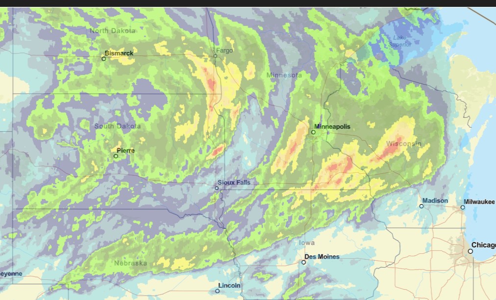
That’s a lot of territory that got a steady rain today. That’s great, but of course it came on the weekend, and at the end of the season. Beggers can’t be choosers.
There will be more to come tomorrow and lastnig to the early part of next week.
from Victoria-Weather

That’s a lot of territory that got a steady rain today. That’s great, but of course it came on the weekend, and at the end of the season. Beggers can’t be choosers.
There will be more to come tomorrow and lastnig to the early part of next week.
It’s going to be a bit of a rainy weekend in Minneapolis-St. Paul this weekend. Hooray! The first batch of rain will arrive late this evening, giving way to a bit of a break tomorrow, followed by the threat for strong thunderstorms (though the heaviest storms will come south of Minnesota) on Saturday, and some lingering rain on Sunday. The area needs to be replenished, but of course, it is all coming on the weekend.
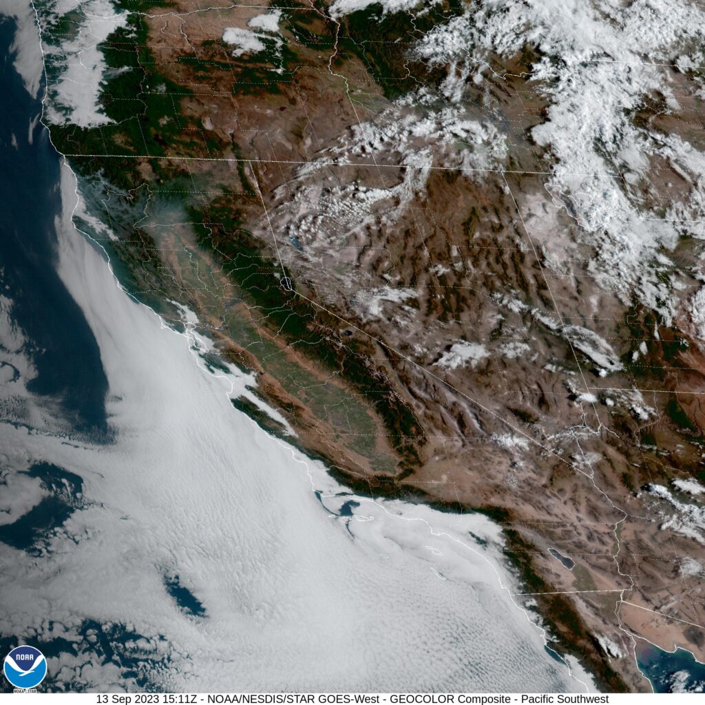
Do you remember all the stories we have heard recently about the western US? I think the most recent weather story was about all the snow and rain the region received first with a vigorous winter and then with the remnants of Tropical Storm Hilary. Now? How about some pleasant, below normal temperatures to wrap up the summer. Weird, huh?
Man, it just seems like the Twin Cities can’t get a drop of rain these past couple of years
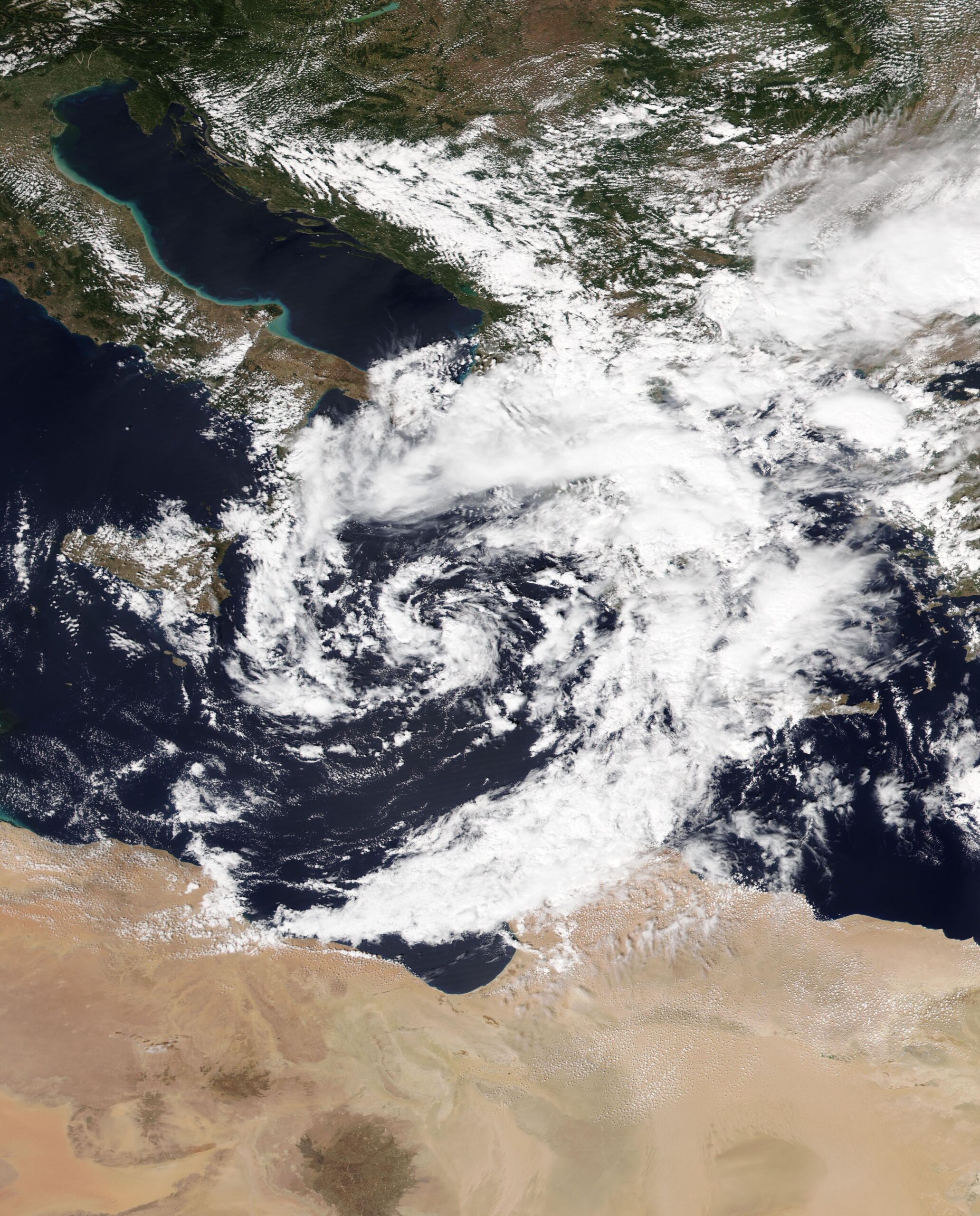
The above is satellite imagery from about 2 weeks ago, as a spiral band from Storm Daniel lashed the Libyan coast east of the Gulf of Sirte. Derna is one of the most northern points of that part of Libya, and suffered the most severe consequences of what was a virulent storm.
Daniel developed in the central Mediterranean, and started making headlines by bringing flooding rains to Greece, where Larissa, in particular, found itself underwater. This was caused by an Omega block, ridges of high pressure that orient the jet in the shape of the Greek letter Omega. This is a generally immobile pattern, and can cause short term drought beneath the ridge, and persistent rain on either side. Daniel wasn’t moving much, wobbling between the southern Balkan Peninsula and northern Libya.
The second accelerating factor was terrain of Libya in general, and the area near Derna, specifically. As you may know, Libya is dominated by the Sahara Desert. There is the Mediterranean climate in the northern coastal areas, so Derna and the other large cities of northern Libya aren’t foreign to rain, but it is pretty dry there, and significantly drier further to the south. It’s not soil that is receptive to rain falling at persistent or voluminous rates. It is prone to running off.

Pictured above is the 3d view looking north from Derna on Google Maps. There is a small river emerging from a network of canyons that cut deep into some cliffs. The entire topography of the region is set up to funnel runoff out of the desert through this canyon and out of Derna. There is a dam at the mouth of the canyon which allowed Derna to exist while also generating some electricity.
There WAS a dam, I should say. Under the onslaught of a cyclone’s worth of rain funneled through the canyon, the poorly maintained dam failed, unleashing all this water on Derna. Undoubtedly, years of dictatorial rule followed by a decade of civil unrest had led to poor civil infrastructure maintenance, and ultimately, tragedy.
As is often the case with the worst disasters, there was a perfect confluence of circumstances that made it so horrific.
Tired of looking at the Tropics? Me too! Check out these storms in western New Mexico.
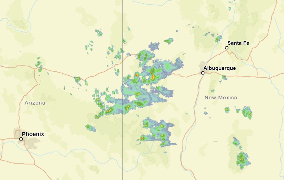
This is some monsoonal moisture, but this time of year, things are moving a little bit more from west to east. This moisture is going to get collected into a developing area of low pressure that will bring a little bit of severe weather to Oklahoma and Texas early this week.
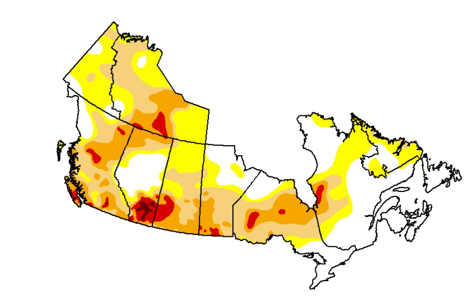
There is a big, sloppy tropical feature blasting through the Canadian Maritimes today. Most of Canada is in the throes of a drought that has brough fires to much of the country and smoke to much of the continent. Most of Canada is in a drought, except for the Canadian Maritimes.
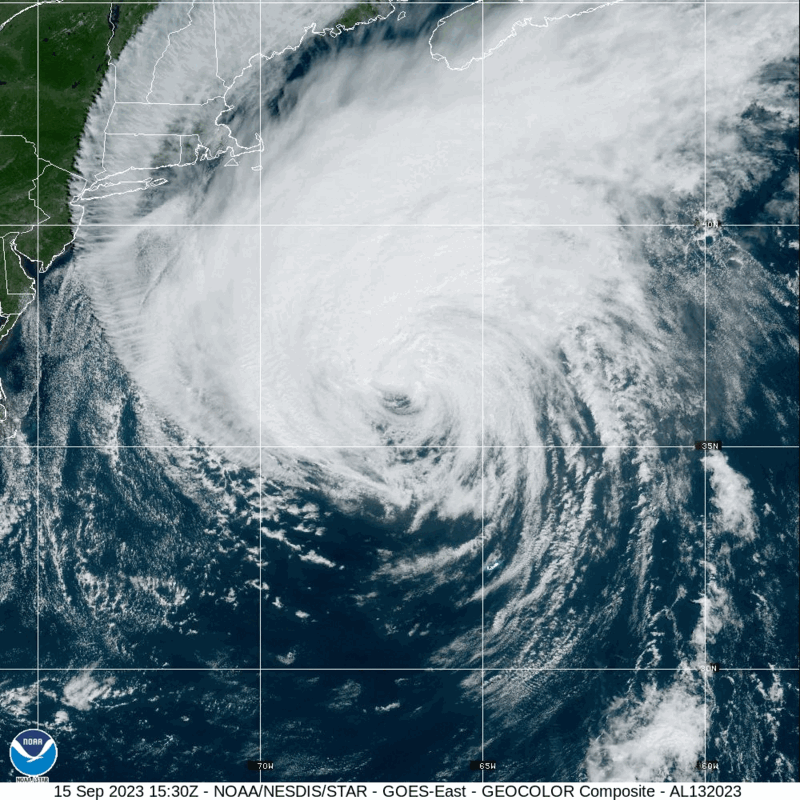
There has been a little bit of positive news from the Atlantic, at least for Stateside interests. The track for Lee has turned a little bit to the right, away from New England and away from the Bay of Fundy, where it could have caused real problems. Instead, the weaker Tropical Storm Lee will land in southwestern Nova Scotia.
Surge and wind threats are lessened for the New England coast, and I’m not nearly as worried about amplified storm surge in New Brunswick, but tropical storm force winds are still going to be an issue for this area, even for parts of down-east Maine, which will get lashed by rain and tropical storm force winds, but the threat, at least in the States, will not be as severe or widespread.
Tropical storm force winds are still anticipated in the southern part of Nova Scotia and parts of coastal New Brunswick, but again, Lee is weakening, and it won’t be a hurricane making landfall in the Canadian Maritimes. The storm will make landfall around Yarmouth, Nova Scotia tomorrow morning, around 8am, CT, or 10 Atlantic time.
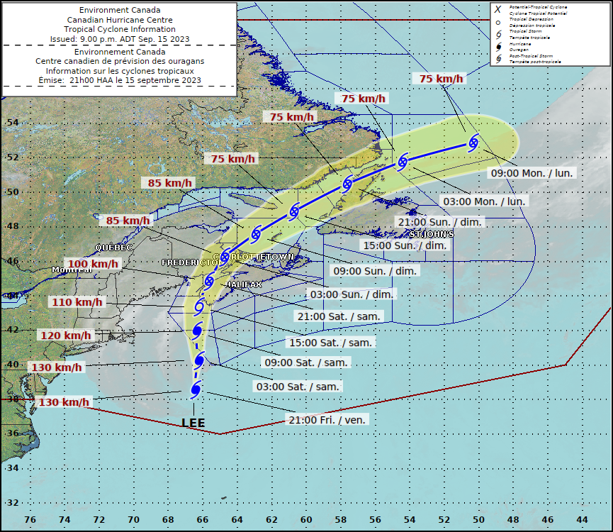
It’s been a long wait, and fortunately, Lee is looking like he showed his worst in the open ocean, and a bullet was almost dodged.
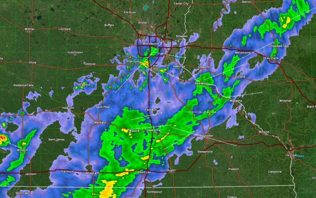
Of further note, the rain is falling on Friday morning instead of over the weekend as well! Red letter day in Minneapolis-St. Paul!
Lake Havasu City is probably one of the longest names for a a forecast site that we have. On the other hand, it’s position between Las Vegas and Yuma typically means a particularly brief forecast.
At 815AM, PT, Lake Havasu City was reporting a temperature of 84 degrees with fair skies. Dew points in the area were in the low 50s, though that isn’t terribly absurd for this time of the year, with the monsoon active. Most of the wet weather is at elevation, and will continue to be so in the eastern part of Arizona.
An upper level trough is on its way into the northern Rockies, which will reorient the regional flow. Cooler, denser air will be angled off the Pacific towards Lake Havasu City, and will have a difficult time reaching the area. Dew points are expected to drop, and the threat for clouds or spotty rain showers will disappear with the feature’s arrival.
Tomorrow – Mostly sunny, High 98, Low 76
Friday – Sunny, High 100, Low 80
TWC: Tomorrow – Sunny skies. High 100, Low 79
Friday – A mainly sunny sky. High 102, Low 78
AW: Tomorrow – Plenty of sun High 99, Low 79
Friday – Plenty of sun High 102, Low 77
NWS: Tomorrow – Sunny High 96, Low 80
Friday – Sunny, High 97, Low 79
WB: Tomorrow – Sunny, High 99, Low 77
Friday – Sunny, High 100, Low 78
WN: Tomorrow – Sunny, High 101, Low 79
Friday – Sunny, High 103, Low 78
CLI: Tomorrow – Sunny, High 100, Low 79
Friday – Sunny, High 102, Low 79
A little variety to the forecast in Lake Havasu City. I’m a little surprised that this is how it shook out. Satellite is clear in California, and getting clearer in Arizona.