
9:46PM: It’s the longest day of the year, which for our purposes means more heat of the day to touch off air mass thunderstorms. A lee trough is bringing weather to the Front Wave, but even with the extra sun, it’s pretty quiet in the middle of the country. Storms, for sure, but the only warning east of Colorado at the moment is in southeast Virginia.
Blowing through
It’s been a stormy June, and even now, it remains stormy between the Ohio Valley and Great Lakes. We had a forecast last week for South Bend, which looked like a couple of days that were going to be stormy. In the end, only Thursday saw storms (though rainfall was not quantified through our monitoring station) that had nearly severe winds. Accuweather had the only correct rain forecast, which lined up with a top temperature forecast. Temperatures on Thursday were held in check by the stormy activity, which kept scores down.
Actuals: Wednesday, June 10th, High 90, Low 71
Thursday, June 11th, High 84, Low 65
Grade: C
Updates 6/21
12:20AM: Like I said earlier, happy Father’s Day! If you are looking for information on our most recent forecast city, I can tell you that things are going extremely quietly for Longview, as east Texas is completely unbothered by showers or storms. Will that hold? Not for the whole region, but maybe in Longview, specifically!
Updates 6/20
10:57PM: The current round of severe weather, while intense, is certainly in a safer place than it has been lately. As storms continue to the east, they will slide further south than storms that we saw last week, and with a lot less vigor. Happy Fathers Day!
Updates 6/19
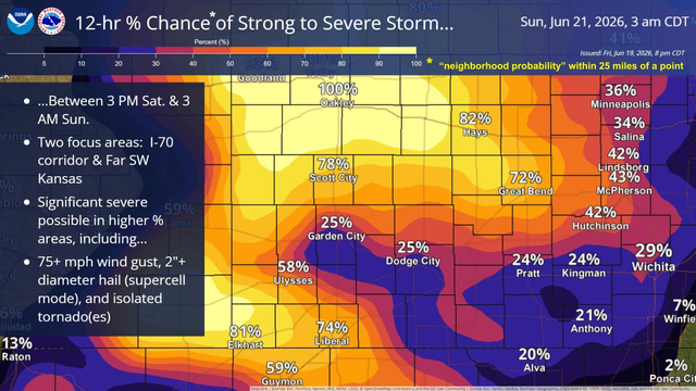
9:23PM: Today was a bit calmer across the country, but business will pick up again in the central Plains tomorrow. Here is a graphic I’ve not seen before, but it promises a busy day in Kansas and Nebraska
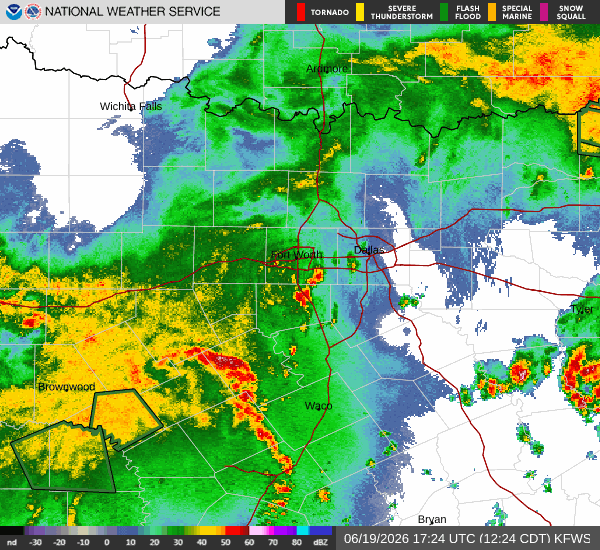
10:53PM: This is a mild version of what I expect eastern Texas to look like tomorrow. Stronger activity, maybe a little convection, but not organized, not scary.
Longview, Texas
The middle of the week has been rife with severe weather. There is more in the mid-Atlantic, but things are finally beginning to look a bit more relaxed. How relaxed in east Texas?
At 1153AM, CT, Longview was reporting mostly cloudy skies and a temperature of 73. The lingering boundary that has been a significant weather maker in the southeast this week now lay from Jacksonville, Florida to a secondary surface feature southeast of Texarkana. A band of showers and storms has slid southeast of Longview, but a batch of showers continues near Dallas, and a dry afternoon is unlikely.
There is a low level perturbation seated over southern Missouri that is going to continue to enhance shower and storm activity through the day tomorrow. The more significant jet streak is shifting to the east, with a weak ridge snuffing out the weak low in the south central US. Further bringing about some stability to east Texas is a surface system developing in the Front Range late Saturday, shifting into central Plains on Sunday. This will lead to rising heat and humidity, but clearer conditions, with only a couple of pop up thunderstorms.
Tomorrow – Scattered showers and storms, High 83, Low 73
Sunday – Clearing and warmer with isolated showers, High 90, Low 75
TWC: Tomorrow – Scattered thunderstorms in the morning. Cloudy skies late. High 83, Low 72
Sunday – Partly to mostly cloudy. High 88, Low 73
AW: Tomorrow – Humid with intervals of clouds and sunshine High 83, Low 73
Sunday – Humid with sunshine and some clouds; a thunderstorm in spots in the afternoon High 90, Low 75
NWS: Tomorrow – Showers likely and possibly a thunderstorm before 7am, then a chance of showers and thunderstorms after 7am. Cloudy, then gradually becoming mostly sunny High 90, Low 74
Sunday – Mostly sunny, High 93, Low 75
WB: Tomorrow – Mostly cloudy with a chance of showers and thunderstorms. High 83, Low 75
Sunday – Mostly cloudy in the morning then becoming partly cloudy High 89, Low 74
CLI: Tomorrow – Thunderstorm High 83, Low 75
Sunday – Thunderstorm High 90, Low 75
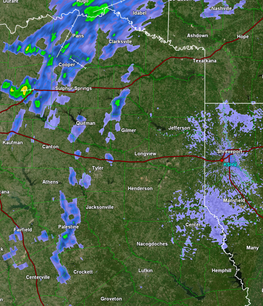
Undersold is that with the low pressure developing to the north, it will also be fairly breezy in Longview on Sunday. Just hot wind. Here’s the diminishing storm activity, depicted on radar!
Updates 6/18
10:04PM There has been a litany of thunderstorms across a big swath of the country this week, and even as the threat for tornadoes, wind and hail abate, the lingering effects of torrential rains remain, and will be enhanced by ongoing showers. Thus, we are looking at ongoing flood advisories in the mid-South.
May Forecaster of the Month
May is our entry into spring and summer. As much as April claims to be, things actually start happening in May. One thing that stayed the same, however, was The Weather Channel’s continued hold at the top of the Victoria-Weather Verification charts. Congrats!
| Outlet | Forecast Wins (year) |
| The Weather Channel | 4.5 |
| Clime | 2.33 |
| National Weather Service | 2.33 |
| Accuweather | 2.33 |
| WeatherNation | 2.16 |
| Victoria-Weather | 1 |
| Weatherbug | 0.33 |

South Bend, Indiana
As a proud grad of Purdue University, I will very begrudgingly issue this forecast. Buckle up, it could be a fun one.
At 1003PM, ET, South Bend was reporting a temperature of 77 degrees with mostly cloudy skies. A band of showers and storms had moved into the eastern part of the state, leaving a humid night for northern Indiana. This should leave the area primed for more sultry conditions tomorrow.
There won’t be a triggering mechanism, save for the latent heat and humidity for tomorrow, but that could be enough for a few stray storms in the afternoon, none of which are likely to be severe. Another band of storms will arrive overnight with a perturbation associated with an area of low pressure moving east through the Canadian Prairies. This complex will hit around midnight and last into the wee hours. The next threat of storms is going to be better organized, and more closely tied to a cold front. This will arrive 24 hours after the first batch, close to midnight Thursday into Friday.
Tomorrow – Afternoon showers and storms, with more action overnight, High 92, Low 73
Thursday – Predawn showers, then storms late, High 89, Low 71
TWC: Tomorrow – Intervals of clouds and sunshine. A stray shower or thunderstorm is possible. High 93, Low 72
Thursday – Mostly cloudy skies with scattered thunderstorms developing later in the day. Some of the storms may become severe. Damaging winds, large hail and possibly a tornado with some storms. High 88, Low 69
AW: Tomorrow -Partly sunny, hot and humid; breezy in the afternoon High 90, Low 71
Thursday – Remaining very warm and humid with periods of clouds and sunshine; severe weather expected at night; be alert and have a way to receive warnings High 89. Low 72
NWS: Tomorrow – A slight chance of showers, then a chance of thunderstorms after 4pm. Partly sunny and hot, High 91, Low 68
Thursday – A 40 percent chance of showers and thunderstorms after 2pm. Partly sunny and hot, High 90, Low 72
WB: Tomorrow – Partly cloudy. A slight chance of showers in the morning then a chance of showers and thunderstorms in the afternoon. High 91, Low 76
Thursday – Partly cloudy. A slight chance of showers in the morning then a chance of showers and thunderstorms in the afternoon. High 86, Low 73
WN: Tomorrow – Partly cloudy with showers and a chance of storms, High 90, Low 70
Thursday – Partly cloudy with showers and a chance of storms, High 90, Low 72
CLI: Tomorrow – Rain showers High 91, Low 69
Thursday – Thunderstorm High 91, Low 71
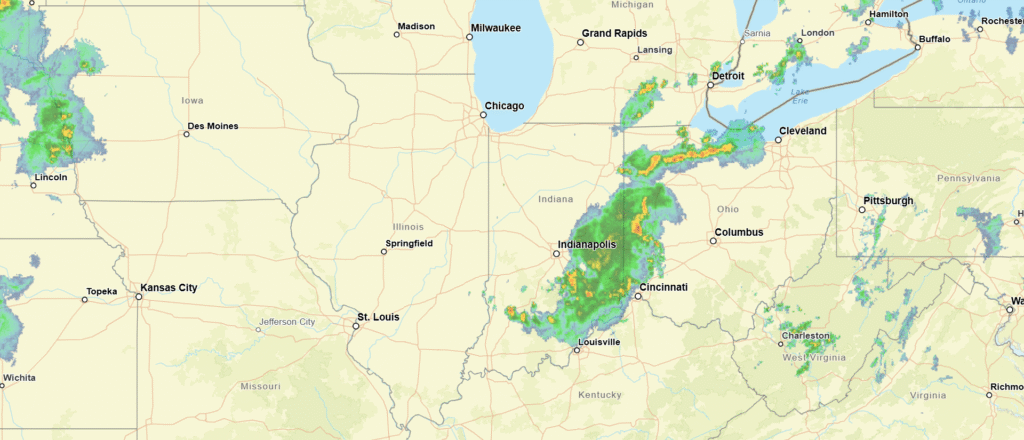
You can see a band of storms drifting into Ohio. Get used to looking at this, South Bend.
Memorial Day sunburn
We took a look at Houston for our most recent forecast, which happened to present a forecast that fell over Memorial Day. We are approaching the summer season for the Gulf, which often means coastal showers and storms on most afternoons. I’m a proponent of including showers and storms in most forecasts down there, because that is often how it is going to turn out. Most everyone agreed with that line of thinking, but The Weather Channel boldly opted to leave precipitation out of the forecast. On this day, none of the rain hit the station at Houston, which turned a Victoria-Weather victory to a Weather Channel one.
Actuals: May 24th, High 86, Low 68
May 25th, High 88, Low 73
Grade: B