Punta Gorda, Florida to Bridgeport, Connecticut

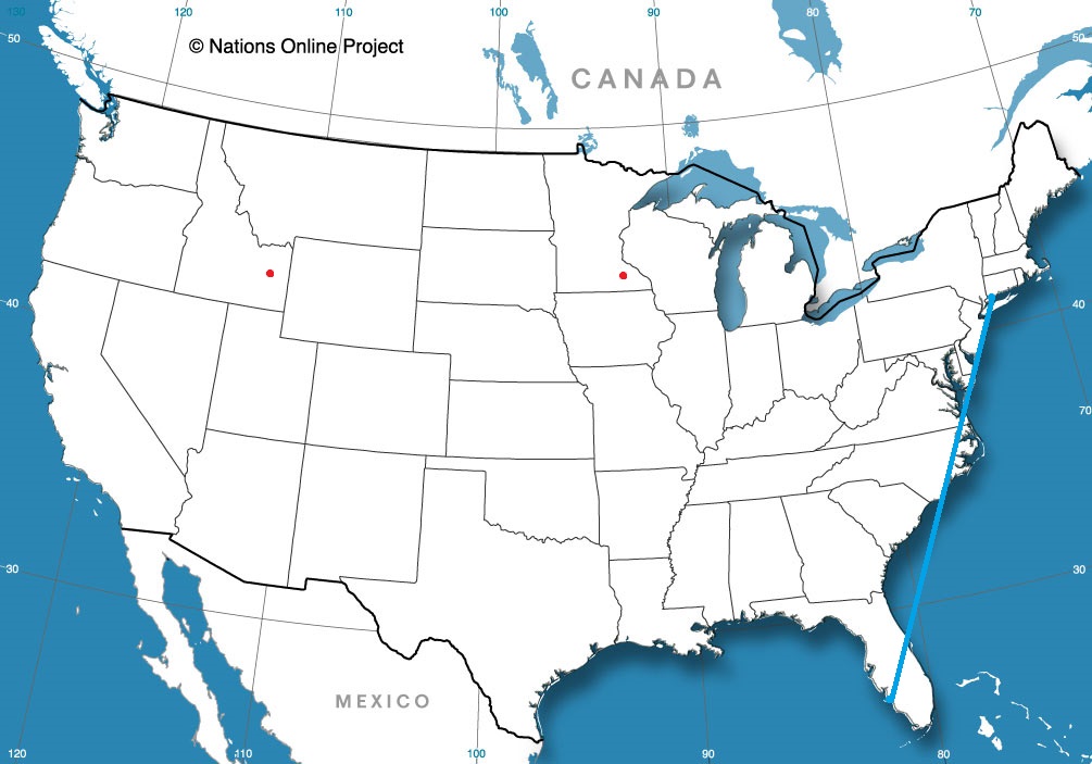
I know how great vacation can be, but driving to Florida along the East Coast seems like such a challenge. But then, getting to La Guardia from Bridgeport doesn’t seem like a lot of fun either, so a 2 and a half day trip it is! We’ll meander over the course of 2 1/2 days at a pace of 62.6mph, which as you should know by now, isn’t very fast. We will cover barely over 500 miles a day on days one and two, with the rest of our 1284 mile journey reserved for Saturday.

Punta Gorda, Florida

DAY ONE (Thursday)
This is the rare August in which the southeast is somewhat synoptically active. There are a lot of showers and storms in the northeastern Gulf as high pressure sinks into the Carolinas. The daily convection in the southeast will likely not make it further north than Gainesville, which means that if we start early enough, we should stay dry all day. Well, save for the sweat we break out into every time we stop for gas. It’s still going to be hot and humid, until we reach Gable, South Carolina, southeast of Sumter. This blog is very into Sumter right now.

DAY TWO (Friday)
High pressure won’t last long in the face of August heat and humidity in the southeast. Alas, a blob of moisture will waft north into Georgia and the Carolinas. We should be sneaking into Virginia by the time it really gets active, but with the moisture wrapping into the eastern exposures of the Shenandoahs and Blue Ridge, don’t be surprised to see some late afternoon haze and clouds, even as far north as Havre du Grace, Maryland, at the northern end of Chesapeake Bay, and our terminus for the day.

DAY THREE (Saturday)
Further north, high pressure often has a greater toehold, and that will be the case on Saturday. A wedge of dry air associated with low pressure in Canada will make itself at home in between the moisture blob to the south and that same area of low pressure. It’s going to be a bit of an intense day of driving, as we pass through the southern and eastern parts of the Philadelphia metro, and then right through the heart of New York, but it should be worth it, as Bridgeport is in for a fantastic start to the weekend.

Bridgeport, Connecticut

Popocatello

Popocatepetl is a volcano in Mexico. Pocatello was a white hot city in Idaho last week. Popocatello is a portmanteau by a meteorologist who thinks he is funny. Victoria-Weather thought it would be even warmer in Pocatello as July faded to it’s conclusion than it actually was, but we still managed to collect a much needed victory.
Actuals: Tuesday – High 93, Low 55
Wednesday – High 93, Low 54

Grade C

Sumter is not Florence

I don’t know what happened to Weather Underground, our traditional source for verification information. This time around, the problem was attribution. They kept reverting back to weather information for Florence when I sought info on Sumter. It’s too bad for us, because we verified better against Florence’s figures. When running the correct verification, Victoria-Weather fell off, and the cooler numbers in the afternoon, with cooler overnight lows gave the win to the trio of Accuweather, The Weather Service and WeatherNation
Actuals: Friday (the 26th) High 86, Low 68
Saturday – High 90, Low 64

Grade: A-B

Rochester, Minnesota

We are going to sneak close to home tonight, going down to Rochester, the home of the Mayo Clinic.

At 1254AM, CT, Rochester was reporting a temperature of 67 degrees with fair skies. Low pressure moving through northern Manitoba is inducing a lot of low level moisture northward, and dewpoints across the region were high. Fog is likely to settle in in low lying areas overnight, particularly given the clear skies.
Between the low in Manitoba and the remnants of a system in northern Quebec, there has been a rise in instability in the Upper Midwest, with scattered showers through Wisconsin on Saturday. The Manitoban low will bring some drier air into northern Minnesota on Sunday, and continue through the southern part of the state on Monday. As a result, shower and storm activity will become more voluminous, and depending on the available energy, there is a chance for some severe weather in the Rochester area on Monday.
Tomorrow – Isolated showers and thunderstorms, High 85, Low 64
Monday – Scattered showers and thunderstorms, High 82, Low 66

TWC: Tomorrow – Sunny, along with a few afternoon clouds. High 85, Low 65
Monday – Mixed clouds and sun with scattered thunderstorms. Storms may contain strong gusty winds. High 81, Low 68

AW: Tomorrow – Partial sunshine; humid High 84, Low 65
Monday – A strong afternoon thunderstorm; storms can bring flooding downpours, large hail and damaging winds High 82, Low 67

NWS: Tomorrow – Patchy fog before 8am. Otherwise, mostly sunny High 85, Low 63
Monday – Showers and thunderstorms likely, mainly before 1pm. Partly sunny, High 85, Low 66

WB: Tomorrow – Mostly sunny, patchy fog in the morning, High 84, Low 65
Monday – Numerous showers and thunderstorms, high 82, Low 68

WN: Tomorrow – Partly cloudy High 85, Low 63
Monday – Partly cloudy with numerous thunderstorms, High 85, Low 66

FIO: Tomorrow – Partly cloudy throughout the day. High 85, Low 65
Monday -Rain in the afternoon and evening. High 83, Low 69

The timing everyone has for precipitation is all different. Several outlets have rain starting shortly after midnight on Monday, while others don’t have it until the evening. Meanwhile, we have a chance on Sunday. Here is a loop of the day’s satellite imagery, showing the thunderstorms moving through Wisconsin, and fog developing up by Duluth.

An ineffective cold front

Back in mid – July (that’s how far behind I am on these verifications) we looked at the western Michigan town of Muskegon, which was to receive a healthy wallop from a mass of storms moving through Minnesota and Wisconsin. Those storms proved stronger than expected in the Upper Midwest, and generally lasted longer in Michigan than anyone thought. What really surprised all outlets was how little the high temperature was impacted on Sunday the 21st. After a high of 89 on the 20th, it only dipped to 87 for a high on Sunday. Not really a terrific forecast, but not really terrific weather, either.
Actuals: Saturday – .51 inches of rain in thunderstorms, High 89, Low 71
Sunday – Thunderstorms reported, not measured, High 87, Low 69

Grade: C-D

Pocatello, Idaho

Something about Pocatello always seemed interesting to me. If I’m being honest, I think I just like the way the name sounds.

At 127PM, MT, Pocatello was reporting a temperature of 83 degrees with a brisk wind from the northeast, right down the Snake River Valley. There is a general area of showers in the higher terrain east of Idaho Falls contributing to the brisk winds, and any lightning that results from these showers will be particularly dangerous, as the region is tinder dry.
A weak ridge over the Rockies is no match for the monsoon, which will continue to bring showers and storms to the Tetons, particularly in the afternoon for the next two days. Showers and storms aren’t likely to settle down into Pocatello, but similar to today, wind is likely to rush in and the fire threat probably won’t abate.
Tomorrow – Partly cloudy and hot, High 95, Low 53
Wednesday – Mostly cloudy, High 96, Low 57

TWC: Tomorrow – Sunshine along with some cloudy intervals. High 94, low 57
Wednesday – A mix of clouds and sun early, then becoming cloudy later in the day. High 91, Low 61

AW: Tomorrow – Partly sunny; hot High 95, Low 58
Wednesday – Rather cloudy High 92, Low 59

NWS: Tomorrow – Sunny, High 93, low 61
Wednesday – Partly sunny, High 91, Low 61

WB: Tomorrow – Sunny, High 89, Low 57
Wednesday – Mostly sunny, High 88, Low 57

WN: Tomorrow – Mostly sunny, High 93, Low 60
Wednesday – Partly cloudy, High 91, Low 63

FIO: Tomorrow – Partly cloudy throughout the day. High 94, low 59
Wednesday – Mostly cloudy throughout the day. High 93, Low 62

Look at that range in high temperature forecasts! For a forecast with no rain involved, we can brand this as E for exciting. Here is a look at the radar, with those storms over the Tetons.


Always bet on thunderstorms

That’s generally the rule of thumb for forecasting in Florida, especially in the summer months. Last weekend was our valid time for our forecast for Deltona, and there were a handful of outlets that unconscionably left rain out of the forecast one one or both days. Mistake. Because we stuck to our mantra, we won the forecast despite some pedestrian temperature forecasting.
Actuals: Friday – .36″ of rain in thunderstorms, High 95, low 75
Saturday – High 93, Low 75

Grade: B-C

Sumter, South Carolina

Sumter is sort of an in between town. It’s not a coastal town, but it’s not very far inland either. What is the leading factor in the weather in Sumter? I reckon’ we’re about to find out.

At 1055AM, ET, Sumter was reporting a temperature of 81 degrees with sunny skies. After a muggy weekend, an unseasonably strong cold front has swept unpleasantness off the coast, and high pressure has built into the Carolinas.
The remnant boundary will lay astride of the coast, and within the convective remainder, a tropical wave will become involved and briefly intensify before pulling the dry continental air further into South Carolina, and the showers and storms at sea further into the Sargasso. All the while, Sumter looks to enjoy a whole lot of sunshine.
Tomorrow – Mostly sunny, High 89, Low 65
Saturday – Hot but clear, High 90, low 64

TWC: Tomorrow – Sunshine and clouds mixed. High 88, low 66
Saturday – Plentiful sunshine High 89, Low 65

AW: Tomorrow – Intervals of clouds and sunshine High 87, Low 66
Saturday – Mostly sunny High 89, Low 65

NWS: Tomorrow – Partly sunny High 88, Low 67
Saturday – Mostly sunny, High 89, low 65

WB: Tomorrow – Partly sunny High 87, Low 68
Saturday – Mostly sunny, High 87, low 67

WN: Tomorrow – Partly cloudy High 88, Low 67
Saturday – Mostly sunny, High 89, low 65

FIO: Tomorrow – Mostly cloudy throughout the day. High 88, Low 69
Saturday – Partly cloudy throughout the day. High 89, Low 67

All told, especially after this past week, that’s not really a bad outlook for South Carolina. Here is a look at the western Atlantic satellite, showing the instability off shore.

It’s the nights that are oppressive

A lot was made of the heat indices in the 110’s across a broad swath of the Plains east through the Great Lakes to the Mid-Atlantic, but Huntsville is at higher elevation, and was battling an area of low pressure that was bringing clouds to the region and some spots of rain near (but not in) Huntsville on Friday and Saturday. Temperatures, as a result, barely scraped 90. Still hot, but not as hot as it could have been. The problem was overnight, when lows were in the muggy low 70s. That’s tough, as the body can’t cool down and recharge, and is an underrated danger of heat waves. As for the verification of Thursday’s forecast, there was a quartet of forecasters on level pegging: Victoria-Weather, The Weather Channel, Accuweather and Forecast.io.
Actuals: Friday – High 90, Low 73
Saturday – High 88, Low 72

Grade: B-C