Well, ok, as you can see from these stories, there is a long strand of wet weather straddling the east coast through the mid-Atlantic. Once you are a little bit inland, though, happy opening day, baseball fans!
The coming stretch is going to be heavy on the travel, which makes sense since so many people are on spring break. That explains the forecasts down south as well.
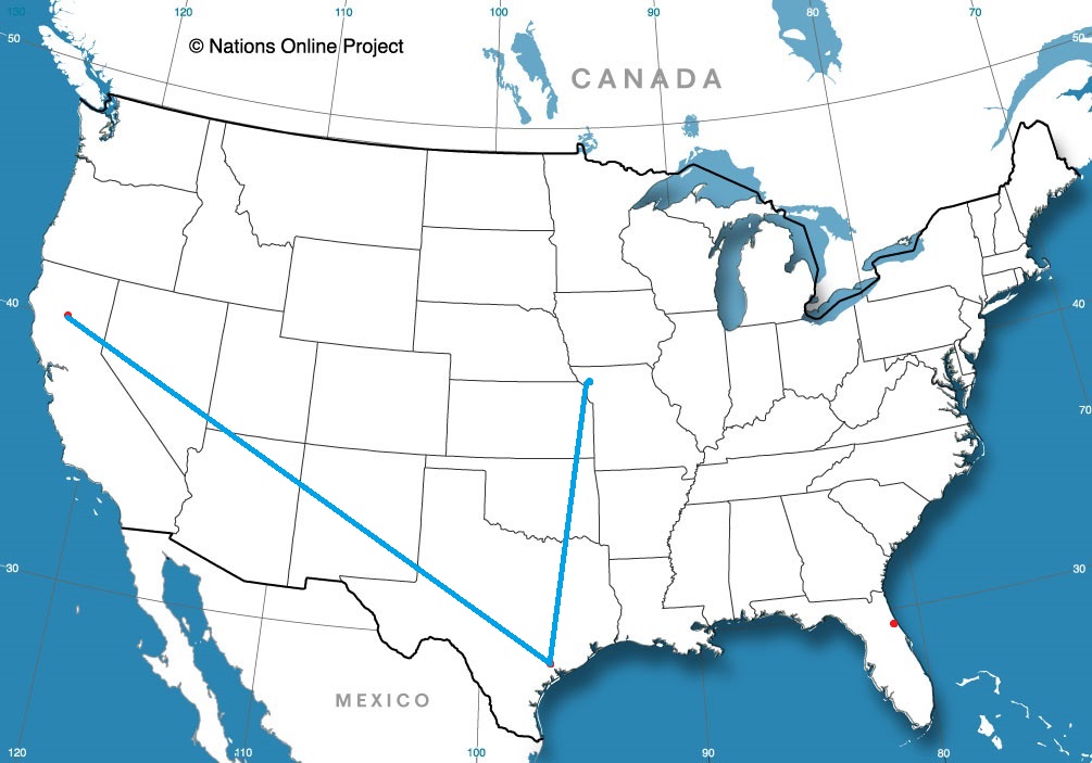
Palm Coast, Florida
Victoria, Texas Road trip from St. Joseph, Missouri to Victoria
Chico, California Road trip from Victoria to Chico
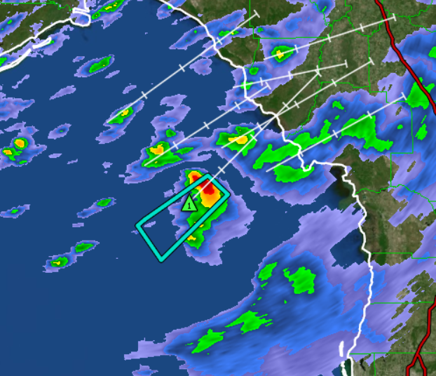
As we learned from our last update, today is the only day to be concerned with rain in the Tampa area. To the north off the coast from Cedar Key, the NWS has issued a Marine Warning that looks strange.
Polygons usually expand through the expected storm motion to account for the potential variability of the track. Instead, this one narrows around the storm motion. That’s just a backwards polygon is what that is.
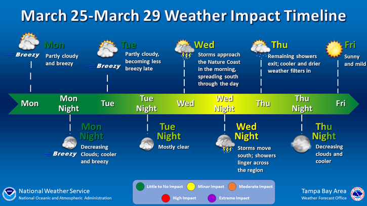
As the Tampa Bay weather office shared recently, this week looks pretty good, save for a little bit of storminess tomorrow. Of course, this is the Gulf Coast side, so the spring breakers in question are probably visiting grandparents.
As seen in the video from NBC news, tragedy has befallen Baltimore Harbor, where a cargo vessel leaving the harbor lost power and steamed directly into a support for the Key Bridge, the outermost bridge spanning the Patapsco River, collapsing the span into the River. Two were rescued, though around 20 drivers and construction workers are through to be missing.
Today, this morning, while time is the most critical for whatever recovery can be done to save lives if possible, the weather was at least accommodating. There were clear skies and the Patapsco was calm, which will allow the waterway to be as clear as the waterway can get. It is a busy thoroughfare for maritime traffic and surrounded by a large city, so it is generally murky, and often quite chilly.
Even after the initial recovery is completed, it will be important to continue clearing the wreckage from the mouth of the Patapsco. Baltimore Harbor is one of the busiest on the Eastern Seaboard, and an important source of goods coming into and out of the United States. The longer the harbor is closed, the more likely it is to make a dent on the economy.
Unfortunately, the weather will not be cooperating in these efforts in the next couple of days. There are storms, both rain and snow, from the Great Lakes to the the Florida Panhandle, and this system is headed eastward. It won’t have much energy or much moisture for the coastal Plains, but it will rejuvenate upon reaching the ocean. Even before moisture falls, inflow will blow right through Chesapeake Bay up to Baltimore Harbor.
Rainfall will likely be most intense on Thursday morning, before a reconstituted system can pull off to sea. For the next couple of weeks, the mid-Atlantic looks to expect normal temperatures, but above normal moisture. The falling rain muddies up rivers, and will not help divers without the aid of sonar. Fortunately, for the long term recovery and replacement efforts, near normal conditions are expected around Baltimore, which means warming temperatures and average precipitation.
Hopefully, this can facilitate a rapid clean up and a return to normal for the city of Baltimore. Victoria-Weather extends condolences to those who have lost during this tragedy.
Last weekend, a system moved through the Great Lakes and eventually spiraled through the mid-Atlantic with a copious amount of rain falling around New York over the weekend. But we are here to talk about Columbus. In my forecast I noted that I thought Friday would be on the overcast side, and little did I know how thick those clouds would be. Temperatures were forecast to hit the low 60s on Friday, and they didn’t even get out of the mid-40s. I did say it would be warmer, and it was only 42 on Thursday! Ugh. There was a three way tie between The Weather Channel, Weather Service and Weathernation. Actuals: Thursday – High 41, Low 23 Friday – .19 inches of rain, High 45, Low 29
At this point, most of the precipitation in southern Minnesota is falling as rain, and even then, there is a dry slot right over the Twin Cities metro area that isn’t being picked up well by models. Right now, the NAM model has among the better solutions, but the best bet is looking at the short range models. One thing all of them are consistent on is a reformed area of low pressure and another blast of nasty, and this time windy, conditions overnight.
I wrote last week about the strange forecast coming up for the Twin Cities, where some forecast outlets were calling for a ton of snow, despite so many factors working against a huge accumulation. Well, the storm is nearly over (a recap on that through some updates on the site later) in Minnesota, but the system is still around, and bringing some severe weather concerns in the deep south.
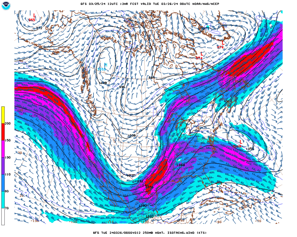
A strong jet flowing north-northeast to the Ozarks, sequestering a pocket of energy in the Mississippi Delta
The jet across the country is strong, a common scenario when encountering spring season storm threats, and it is helping the system in the Plains occlude fairly quickly, with an additional area of low pressure developing at the surface northwest of the Mississippi Delta. There is a copious amount of moisture down here, as always, but now also quite a bit of turning in the atmosphere, or vorticity.
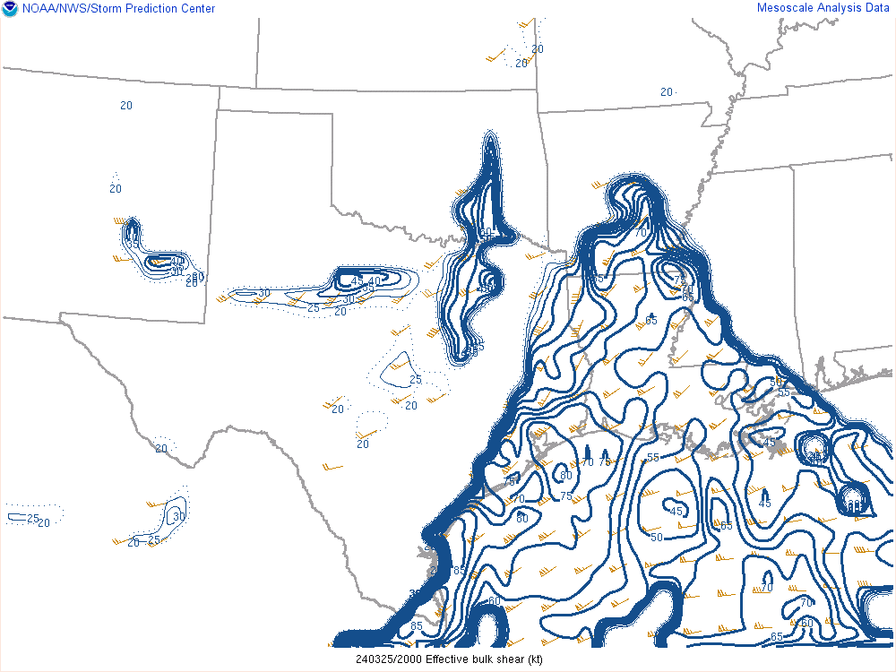
The vorticity is compounded by the fact that the wind is changing directions. While the wind at 250mb, as above, is coming from the southwest, winds at different levels of the atmosphere are angled at different directions. This is called vertical shear, and is something that can help a storm build upwards quickly, and produce twisters at the surface. The area bracketed by the blue has the greatest shear, and will move east into Mississippi overnight, following the storms.
There are already some bands of storms, though none of it yet severe, moving through Louisiana, and it looks like if any storms develop, they will be embedded within a line with rain falling around it. This is a typical mode for “Dixie Alley” where storms make themselves nearly impossible to find, not only by occurring in a tree filled environment, often at night, but also by usually falling in the midst of especially rainy thunderstorm complexes.
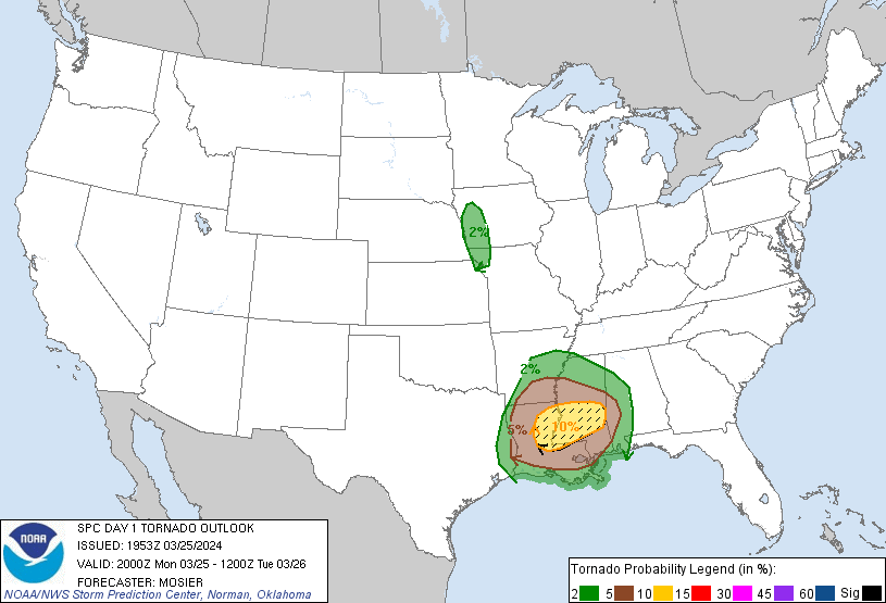
The NWS is calling for a chance for especially large and dangerous tornadoes tonight, potentially in Jackson, Natchez or Meridien, and it is important to stay vigilant as the storms develop and move into the area. There are no basements, generally, in Mississippi, so ensure a spot in a storm shelter if storms loom.
Storms will likely continue deep into the night, but the low across the center of the country will be too stretched to allow for things to continue far into Alabama or Georgia tomorrow. Additionally, there will be a pause in the rough stretch of weather, allowing Delta residents a chance to breath and recover, if necessary. Let’s hope it isn’t.
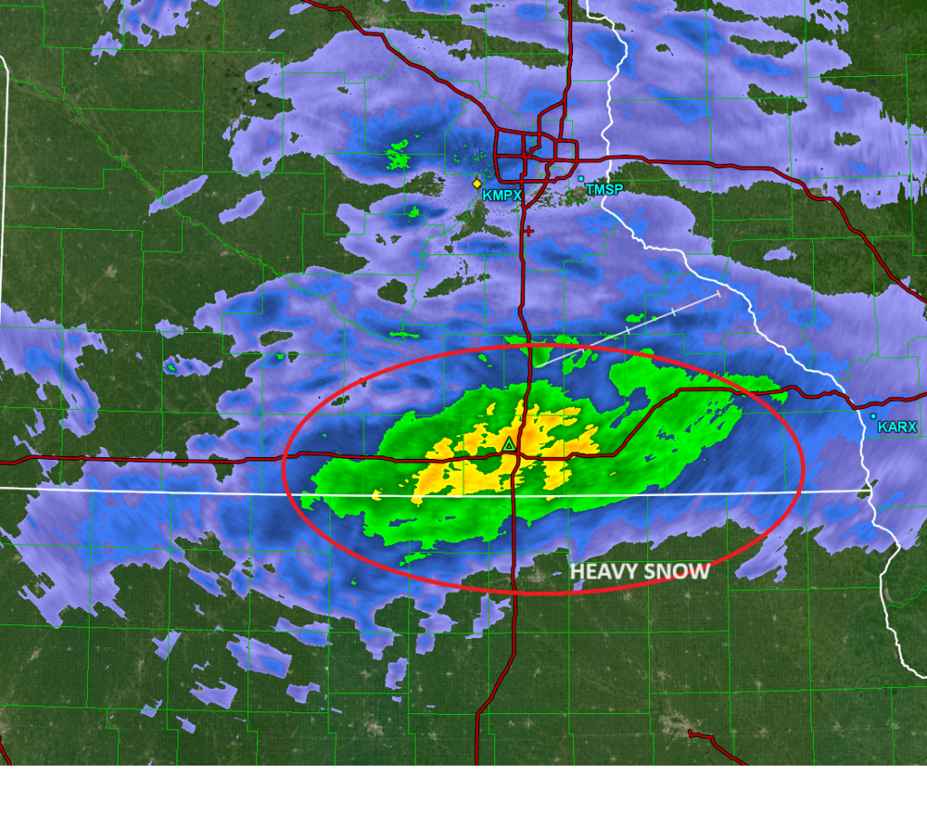
A band of very heavy snow is presently just north of the Iowa border in Minnesota. At Austin, they are reporting some thunder along with the snow, indicating the rapid rate that the precipitation is falling, and the energy in the system. The change to rain keeps moving up in the forecast though, and will be chasing this heavy band, and we still await confirmation on how much snow we will see
A pair of systems are bringing a taste of winter to the Midwest tonight and with another round coming Sunday night. The feature that has really already occurred in the Upper Midwest is a classic Clipper feature coming right out of Canada. There was a solid 2-5″ in a stripe north of the Twin Cities, and forecasts were pretty consistent on it.
A larger feature moving in this weekend from the central Rockies promises to make for more interesting weather, starting Sunday afternoon and lasting through at least Monday. But how much snow will come out of this system? That’s the big question, and there isn’t really a solid answer, but I’ll do my best to get us there.
My friends started messaging me earlier this week, exclaiming that their weather apps were calling for nearly 2 feet of snow! That seemed ridiculous, and I looked at the various weather models that I use, and ultimately, I came to the conclusion that yes, the forecast of 2 feet of snow in Minnesota was ridiculous. At the time, the feature looked like, at most, a producer of 7-10″ of snow. It now projects as a stronger storm, but 2 feet still seems pretty absurd.
It’s not that there won’t be enough moisture. It’s spring now, and there aren’t any features in the Gulf blocking moisture, but all of the things one looks for in a system that sees snow totals stack up aren’t there in the Twin Cities. Despite the snow that fell overnight last night, there is no snow on the ground for most of the region, and the ground is quite warm.
Also warm: the atmosphere. This system is going to be rising from the south and pulling some warm air northward. This will change some of the precipitation to rain, and failing that, will reduce the moisture to snow ratio. Water crystallizes as it gets colder, so the amount of liquid water it takes to get to an inch of snow becomes less and less. The snow this weekend will fall in temperatures that will be flirting with, if not exceeding, freezing.
There will be a gradual ratio through Minnesota, and some bright bands of heavier and lesser snow owing to some local effects, but not everywhere will hit over 10″. Some places sure will surely avoid the heaviest precipitation and see less accumulation, and some areas will see heavy precipitation that falls more as rain than snow. Somewhere between, there will be a stripe that gets 12+ inches of fresh, wet snow.
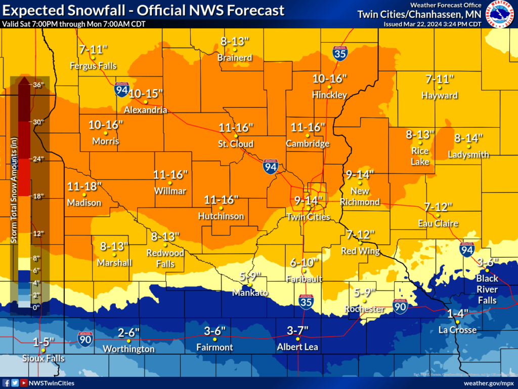
Now, where will that area of heaviest snow be? Let’s see the NWS’s best guess:
Well, that narrows it down. These are the most likely totals, according the NWS forecast, but I also think we should expect the low end of these ranges, especially on the north and south parts of the forecast area.