Dorian devastates Bahamas, batters East Coast

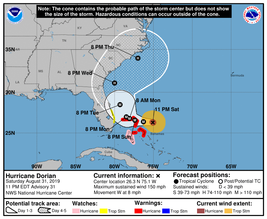
By now, we’ve all heard the stories of utter devastation for the northern Bahamian islands of Great Abaco and Grand Bahama. The initial storm surge put a lot of Abaco underwater at the initial landfall, and many deaths on the island were the result of drowning during the storm surge, while in this case, the eye’s passage overhead provided a chance for many to get to higher, safer ground.

The storm then sat and spun over the eastern side of Grand Bahama, cutting the largest city, Freeport, off from the rest of the island. The destruction there, thanks to persistent triple digit wind speeds and a very high storm surge, is comprehensive.

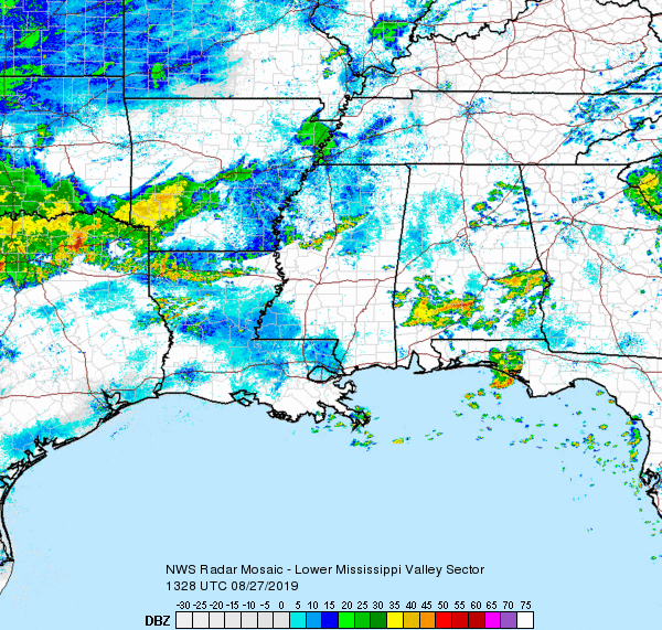
Dorian’s slow down fortunately spared the Floridian coast from the worst damage, but the storm spiraled northwards and pummeled Georgia and the Carolinas with rain, storm surge, tornadoes and category 2-3 winds, before it made a brief trek over the Outer Banks, with a landfall at Cape Hatteras. Take a look at the radar imagery to see how close the eye was to Charleston and Wilmington at various points.

Dorian moved away from the Carolina coast and as he weakened, broadened his footprint, meaning more rain and cloud cover further from the center of the storm. A course directly up the Gulf Stream and away from land will allow for maintained intensity until he made another landfall, this time over the weekend in the Canadian Maritimes.

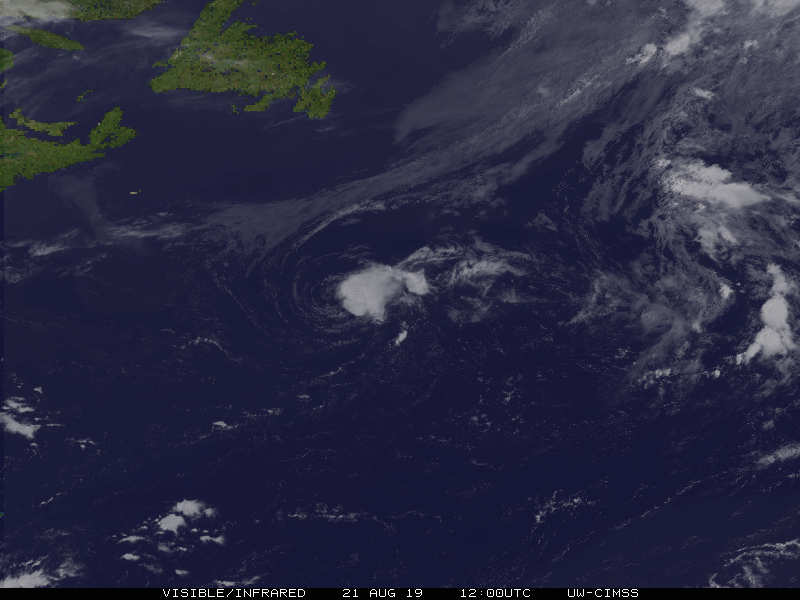
Dorian tracked directly over Halifax, Nova Scotia with hurricane strength winds, and thought it didn’t approach the intensity it had when the storm swept through the Bahamas, he did considerable damage there as well.

The above video provides a good recap of the storms entire course. At least 45 people are confirmed to have died in Dorian’s path, with the majority of the fatalities in the Bahamas, though many more are possible when the affected islands are accessible.

If you can help out and choose to do so, the Red Cross is always accepting donations.

Fresno, California

All eyes remain on Dorian as he batters the northern Bahamas, and we can openly speculate on his further track. It appears as though his course will mean a greater threat for the Carolinas than Florida. Last year, California bore the brunt of weather headlines for much of the year, thanks to drought and fires. This year, California is mercifully off the radar. Let’s check back in.

At 953PM, PT, Fresno was reporting fair skies and a temperature of 87 degrees. While not humid, the dew point was certainly a bit warmer than normal for central California. Despite that, the Golden State was clear, though the monsoon was active with heavy storms over Arizona.
Monsoonal activity will diminish tomorrow, though some high peak showers and storms will be possible, but settled into the valley, a little bit of morning haze will burn off quickly, with hot sunny skies in the afternoons.
Tomorrow – Sunny and hot, High 102, Low 72
Tuesday – Sunny and hot High 102, Low 74

TWC – Mostly sunny skies. High 103, Low 73
Tuesday – Mainly sunny. High 102, Low 73

AW: Tomorrow – Mostly sunny; hot High 103, Low 73
Tuesday – Mostly sunny; hot High 102, Low 72

NWS: Tomorrow – Sunny and hot, High 100, Low 73
Tuesday – Sunny and hot, High 100, Low 73

WB: Tomorrow – Sunny, High 102, Low 74
Tuesday – Sunny, High 101, Low 74

WN: Tomorrow – Sunny, High 100, Low 73
Tuesday – Sunny, High 100, Low 73

FIO: Tomorrow – Partly cloudy throughout the day. High 103, Low 71
Tuesday – Clear throughout the day. High 103, Low 71

The forecast is quite warm, but it’s interesting that the Weather Service is the coolest outlook. That’s not how it usually goes. Chec out this crystal clear satellite.

Unbreakable

The forecast in Monroe seemed promising. There was a little bit of rain in the early part of Wednesday, but then the heat was supposed to break. It certainly did not. Instead, high temperatures remained in the mid 90s, which was just as hot as it was before a weak cold front slid through. The National Weather Service and Weathernation weren’t optimistic about a cool down, and ended up claiming a forecast victory.
Actuals: Wednesday – Thunderstorms reported, not measured, High 95, Low 72
Thursday – High 95, Low 70

Grade: C

Dorian is a Cat 5, but may spare the coast

Because of the slowed down pace, Dorian was able to deepen further than forecasts originally expected, and has become a Category 5 storm as it bears down on the northern Bahamas. It has developed a well defined eye, as a symbol of it’s strength.

That’s a remarkable satellite image, in all of the worst ways. Dorian is going to prove very dangerous to the northernmost islands of the Bahamas, and it appeared he was on his way to becoming the strongest storm to hit the east coast of Florida since Andrew, but alas, that slow pace may have spared Florida the worst.

The slow pace has allowed Dorian to reach the Gulf Stream as what had been a stout Bermuda high breaks down. Instead of intercepting Florida, Dorian is expected to veer poleward to such a degree that he may not make a continental landfall until Nova Scotia.

The NHC maintains warnings for the northern Bahamas, particularly Great Abaco and Grand Bahama, which look to bear Dorian’s full brunt over the weekend, but at this time, only a tropical storm warning has been issued for a small stretch of Floridian coastline.

Dorian remains a danger, of course. The Bahamas in particular are in imminent danger, and even if the storm stays off shore as is now anticipated, waves of thunderstorms will still sweep from Florida to the Carolinas, with flooding a distinct possibility. There may be some lower end hurricane winds as well, particularly north of Miami, and in the Outer Banks of North Carolina. Even with these threats, though, it’s hard not to view the latest forecasts as anything but good news.

Dorian looks like trouble

Dorian has just now been upgraded to hurricane status. He presently sits to the east of Puerto Rico, and will move across the virginiaIslands. Forecast trends have been for a slower progression, a bit removed from the Bahamas, both of which are trends that indicate a stronger storm than had been originally forecast.

Not last week, we were discussing the timid nature of Chantal, as she spun into the north Atlantic. Dorian was initially thought to be another fish storm (after he encountered the Lesser Antillies, of course) but now, the storm is getting slower, and is missing out on the steering flow that instead grabbed the short lived Erin, who is now spiraling off after Chantal.

Dorian is now expected to swing north of the Bahamas before curling back to the west towards Cape Canaveral in about 5 days time, with a landfall sometime this weekend. This is still quite a ways out, and there is certainly plenty of time for things to change, a caveat that is always in place for tropical features, but things aren’t breaking well in the last 48 hours.

A slower course will allow it more time to ingest warm, energizing ocean water, which would have been ok, if it had continued on it’s original course over Puerto Rico and Hispaniola, and through the Bahamas. Instead, it’s jogged east and north, avoiding most of the major landmasses in his way. Now, Dorian, which looks to take an unimpeded run at the Florida coast, may arrive as a major hurricane over Labor Day weekend.

If high pressure doesn’t develop with the strength expected over Bermuda, the storm may shift north, but if it does, it will press south. If the storm tracks directly over some islands, or shear is greater than expected, then Dorian will end up weaker as he landfalls on the Florida Coast. Unfortunately, none of those things seem as though they are expected to come to fruition.

The below track and intensity projections don’t ingest the European model. If they did, they would likely be more aggressive on a land fall closer to Vero Beach and Fort Pierce, with a bit more of an intensity peak at landfall. We’ll try to keep you updated here and on Twitter.

Monroe, Louisiana

Today’s forecast brings us to northern Louisiana. The weather here tends to be less ‘coastal’ and seems to be more at the mercy of the factors that drive the weather elsewhere in the southern Plains and lower Mississippi Valley.

At 818AM. CT, Monroe was reporting light rain with a temperature of 77 degrees. A large area of showers and thunderstorms lingered over northeast Texas, and extended a narrow tendril of rain through northern Louisiana. This outflow boundary suggested that the overnight convection was dissipating for the time being, but it seemed unlikely that the storm machine would be out of commission very long.
A deep area of low pressure was spinning in western Ontario, draping a long, winterlike cold front through the Plains and into the Red River Valley. The length and orientation of the boundary seemed to indicate that the feature wouldn’t be moving with any urgency. The scattered showers and thunderstorms will be an ongoing threat today into tonight. the front will linger over central Louisiana through the day tomorrow, which might mean some more clouds and spots of rain. The low will shift to the northeast through the period, and this will allow the front to diminish. high pressure will take over for Thursday, and it may be a tick cooler than it’s been lately over the next couple of days.
Tomorrow – Mostly cloudy, with isolated showers, High 86, Low 74
Thursday – Mostly sunny, High 91, Low 70

TWC: Tomorrow – Thunderstorms likely in the morning. Then the chance of scattered thunderstorms in the afternoon. High 89, low 74
Thursday – Sunny skies. High 90, Low 69

AW: Tomorrow – Intervals of clouds and sun, a couple of showers and a thunderstorm High 87, Low 74
Thursday – Partly sunny High 91, Low 68

NWS: Tomorrow – A 50 percent chance of showers and thunderstorms. Mostly cloudy High 90, Low 74
Thursday -Sunny, High 92, low 69

WB: Tomorrow – Mostly cloudy with a 50% chance of showers and thunderstorms, High 88, Low 74
Thursday – Mostly sunny, High 89, low 70

WN: Tomorrow – Mostly cloudy with scattered storms, high 90, low 74
Thursday – Mostly sunny, High 92, Low 69

FIO: Tomorrow – Light rain tonight and tomorrow morning. High 86, Low 75
Thursday – Clear throughout the day. High 89, Low 70

The radar in Jackson is out, so we will take a look at the big picture. That bowl shaped band of showers moving through the northern parishes of Louisiana is caused by storms to the north beginning to collapse.

Big heat

Everything is bigger in Texas, or so they say. The temperature readings were pretty huge in San Antonio on the 19th and 20th, with the highs reaching triple digits on the 19th, and the upper 90s on the 20th, all while failing to dip below 80 for the overnight lows. That is a big time heat wave. Forecasts all circled the same numbers, so there wasn’t much separation, but a nearer high on the 20th gave Weatherbug the victory.
Actuals: August 19th – High 100, Low 80
August 20th – High 97, low 80

Grade :B

Another Chantal to forget

Tropical Storm names recycle every 6 years, unless they are retired. The powers that be update their lists every once in a great while, but Chantal has been a part of the lists since 1983, a solid 36 years, and six total cycles. Once, in 1989, a Chantal emerged in the Gulf and began dissipating as she hit the Texas Coast. That was the last time we have seen a Chantal of any significance.

2003’s Chantal was as close as we’ve come to remembering any Chantals, with $5mm of damage to the coastline of Belize. All told, given the scope of damage a hurricane can introduce, that’s pretty much coming away Scot free.

But it’s still more than most Chantals can say, including the one that just formed in the way north Atlantic over the last 48 hours. Check out the current satellite imagery of the storm.

Not only is Chantal disorganized, but the closest island is Newfoundland. This Chantal is going to be just as uneventful as previous iterations.

After a busy couple of years, not only is Chantal harmlessly out to sea, she is also the first storm in months. Granted, we are approaching the peak of the season, but there isn’t any development looming quite yet. With any luck, this entire hurricane season is one big Chantal.

Providence, Rhode Island to San Antonio, Texas

We are going to head right into the heat here in the dog days of summer. There will be a point where we have to pass through some storms to get from moderately more tranquil weather in New England to the steamy south, but where will it happen along our 2013 mile journey? And when, over the 4 day trek? As you might be able to establish, we will cover a bit more than 500 miles a day (519, actually) while traveling at a pace just shy of 65mph, which is somewhat slow, thanks to the tangled web of the east coast, and not a fear of impending thunderstorms.

Providence, Rhode Island

DAY ONE (Tuesday)
Naturally, the feature first expected to impact our journey will be a weak shortwave trough moving out of the Great Lakes. Why is this great? Because I’m being sarcastic, and this will be difficult to forecast around. There is consensus that we will be dry through the New York City area, but then it becomes a little dodgier. I think the model that brings a lot of rain to Pennsylvania is doing so because of poor resolution. I think it’s going to generally be mostly cloudy with some isolated spots of rain, but maybe not enough to even turn the wipers on. These dots will be possible for the rest of the journey, though becoming less likely as we pass into Virginia. The day will end in New Market, Virginia, in the northern part of the state.

DAY TWO (Wednesday)
Another wave moving into the Great Lakes is going to carry with it a bit more weight. Inflow towards the low might lead to some fog and haze in the Appalachians and Smokey Mountains, but the potential for heavy thunderstorms will arise in Tennessee. Not widespread, destructive thunderstorms, mind you, but isolated, pop up showers and storms of questionable coverage. The strongest storms will stay west of the Appalachians, and coverage will begin to wane as a strong batch of storms erupts over northern Missouri late in the afternoon. We’ll make it to Reece City, Alabama, northeast of Gadsden.

DAY THREE (Thursday)
I’m not in the market for going out on an island to predict tropical storms, but I will say, there looks like a week area of low pressure developing over the western Gulf through the middle of the week. Alabama will stay dry on Thursday morning, but some scattered showers will pop up fairly early in Mississippi, and we should be soaked through southern Louisiana. Thunderstorms are likely, but I would be surprised if any of this activity is severe. We’ll stop just west of Lafayette, in Scott, Louisiana.

DAY FOUR (Friday)
That at times steady rain, with a few embedded thunderstorms, will continue through western Louisiana, and may even remain a concern as deep into Texas as Houston, but after we reach the western suburbs, I think we are in the clear. Just in time for more oppressive heat! At least there will be a few clouds every here and there, but not enough to make things feel significantly diffeent in San Antonio than they did in Providence.

San Antonio, Texas