Dangerous heat spreading northward

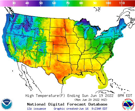
As noted in the forecast for Grand Forks forecast, some oppressive heat is getting ready to surge to the north for Fathers Day and the beginning of next week, It’s already quite hot in the south central US, but after somewhat cool springs, it will be a sudden shot of summer for many in the northern US.

Frequent bouts of severe weather have swept across the region. Strong storms have afflicted every state from South Dakota to Michigan, and even the tier to the south in the last few weeks, indicating for those that didn’t know that the jet stream has lingered over the northern US through much of the spring. The stormy activity and jet’s sag have kept temperatures cool.

Now as we approach the peak sun angle, and the warmth of June, the jet is weakening and starting to wobble. A sharp trough in the Pacific Northwest is going to be a factor in lee troughing in the High Plains, but the troughing will be well ahead of the low, giving a lot of runway to the southerly flow and the warm air that follows. Triple digits may reach the Canadian border.

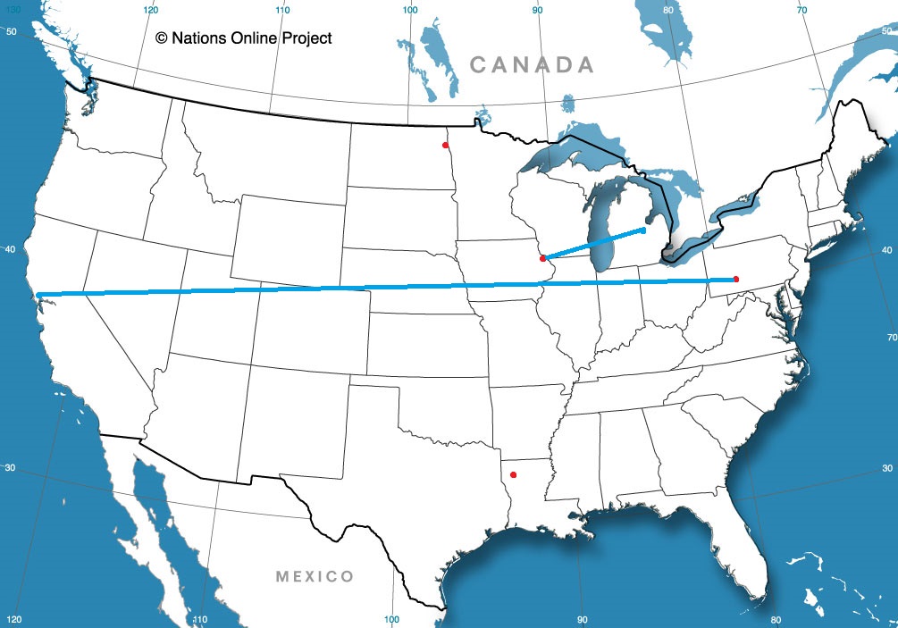
Strong storms are continuing through the eastern Great Lakes after the latest round of severe weather that started earlier this week in Wisconsin and Illinois, but after today’s (enhanced risk) threat of severe storms In New York, Pennsylvania and surrounding areas, the severe threat peters out. A wonderful side effect of the weaker jet is a lower likelihood of strong storms, and this bout of severe weather looks to be the last for at least a few days.

Grand Forks, North Dakota

It’s summer in North Dakota, which means that it will probably be surprising to many how hot it actually gets up there. No matter the temperature, it’s always windy. Always, always.

At 953AM, CT, Grand Forks was reporting a temperature of 67 degrees and fair skies. Winds were howling out of the west at 20kt, with gusts to 31kt. Low pressure moving into Hudson Bay was accelerating winds across the flatlands of North Dakota, but there should be some respite as the system presses northeast towards northern Quebec.
High pressure will build across the area, providing a blissfully calm day on Friday to end the week. A sharp trough over the Pacific Northwest will accelerate some lee troughing in the northern High Plains, and some ridge riding cloud will pass overhead with a warm front early on Saturday. Heat will build as low pressure spreads into Saskatchewan and Manitoba, and accelerates southerly flow through the Plains.
Tomorrow – Sunny, High 85, Low 52
Saturday – Morning clouds, then hot and humid High 92, Low 60

TWC: Tomorrow – Mainly sunny. High 85, Low 54
Saturday – Partly cloudy skies with gusty winds.  High 91, low 63

AW: Tomorrow – Times of clouds and sun High 84, Low 54
Saturday – Partly sunny, windy and hot High 90, Low 62

NWS: Tomorrow – Sunny, High 83, Low 55
Saturday – Mostly sunny and hot, High 90, Low 61

WB: Tomorrow – Sunny, High 84, Low 55
Saturday – Mostly sunny. Windy. High 91, Low 64

WN: Tomorrow – Sunny, High 83, Low 55
Saturday – Mostly sunny, High 90, Low 59

FIO: Tomorrow – Clear throughout the day. High 80, Low 58
Saturday – Windy overnight and in the evening. High 86, Low 60

I’m definitely going warmer. The heat will continue to build, and a run at triple digits is possible for Father’s Day. The trends are going that way, and I am getting ahead of the trend. Satellite shows a wisp of clouds on the back side of the low headed through Canada, and it is windy at the surface. Always windy.

A cool spot

On back to back verifications, we’ve had forecasts that overestimated forecast highs. Because of wind off San Pablo Bay, Napa was colder than forecasts expected earlier this week, and now in Johnstown, the forecast highs were also on the lower side. This time thanks to topography and clouds that settled into the valleys surrounding the Alleghenies. The difference between Johnstown and Napa is that two outlets embraced this possibility. Weatherbug took another victory, but Victoria-Weather wasn’t far behind.
Actuals: Friday, High 66, Low 52
Saturday – Rain reported, not measured, High 66, Low 54

Grade B-D

Shreveport, Louisiana

It’s likely to be hot in Louisiana for our forecast, but at least it’s still only June. Maybe, hopefully, the locals aren’t yet thoroughly exhausted by the heat and humidity.

At 1056AM, CT, it was already 88 degrees in Shreveport, with mostly cloudy skies. Dewpoints in the mid 70s meant it was an absolutely sweltering day in northern Louisiana. It is a late spring pattern without a doubt, with a strong trough near the Canadian border, with a surface ridge becoming established over the southeastern US, allowing it to get to near 100 across much of the region today.
As low pressure moves across the Canadian border, it will induce southerly flow from the Gulf of Mexico across Louisiana, increasing the humidity, but also clouds, which may shave a degree or two off of high temperatures, but it will still be plenty hot. There is a slight chance of rain closer to the coast and east of the Mississippi, but not high enough to leave it in the forecast for Shreveport.
Tomorrow – Partly cloudy, High 96, Low 75
Thursday – Mostly cloudy, High 97, Low 75

TWC: Tomorrow – Partly cloudy skies. Hot and humid. High 97, Low 75
Thursday – Sunny, along with a few afternoon clouds. Hot and humid High 97, Low 75

AW: Tomorrow – Partly sunny and hot; danger of dehydration and heat stroke if outside for extended periods of time High 96, Low 75
Thursday – Partly sunny and hot; danger of dehydration and heat stroke if outside for extended periods of time High 98, Low 76

NWS: Tomorrow – Sunny and hot, High 97, Low 75
Thursday – Sunny and hot, High 99, Low 76

WB: Mostly sunny. Hot, High 95, Low 75
Thursday: Mostly sunny, High 96, Low 76

WN: Tomorrow – Mostly sunny, High 97, Low 75
Thursday – Mostly sunny, High 98, Low 76

FIO: Tomorrow – Humid and partly cloudy throughout the day. High 98, Low 76
Thursday – Humid throughout the day. High 98, Low 77

Oof. Here’s hoping that there are more clouds than are presently in the forecast, and maybe that will be a little bit of relief. It’s pretty clear out there today, though.

Brisk Bay Breezes bring busts

The mountains and waterways of coastal California can lead to a need for microclimate forecasting. This seemed to be the case in Napa, where, sure, a ridge built in, but the southwest winds off San Pablo Bay, often gusting to 20mph, held sway. High temperatures never crossed into the 80s, despite there not being a single forecast lower than 81 degrees. As is typically the case when things skewed towards the low side, Weatherbug was the top forecaster, and it wasn’t particularly close.
Actuals: Tuesday – High 79, Low 51
Wednesday – High 79, Low 56

Grade: B-C

Napa, California to Johnstown, Pennsylvania

Cross country road tripping is the name of the game today, as we start on a 5 day journey. It is a 2,607 mile voyage which we will cover at a pace of 68.6mph, which is indicative of all the freeway time we are spending. That means a 549 mile a day pace for days 1-4, with a shorter drive to finish things off thanks to our blistering pace.

DAY ONE (Friday)

Napa, California

Low pressure over the Gulf of Alaska is pretty much just hanging out in place, and a cold front is becoming mostly stationary in the Pacific Northwest. This is all good news for people chugging along I-80, as we will be on Friday. It will make it hard to leave Napa, though, but driving through Sacramento and Reno will be a bit easier. Our drive will take us to Death Star Valley. Ope, sorry, Star Wars fan. That should be the Deeth/Starr Valley exit in northeastern Nevada.

DAY TWO (Saturday)
The drive through the west will take its typical winding path through Salt Lake City then continue on into Wyoming. There isn’t a lot going on… BUT WAIT! There is a hint that the monsoon might be getting organized by this weekend. If that happens, there is an extremely remote chance at an isolated storm popping up over south central Wyoming by the end of the day. We’ll end the day at Cooper Cove, north of Laramie for our Saturday night stop.

DAY THREE (Sunday)
Lee troughing is going to be fast in developing over central Nebraska, ready to turn towards the Upper Midwest, but it won’t tap into much moisture until it is closer to the Great Lakes. Surface high pressure will be in rapid pursuit, with some convergence and resultant thunderstorms over the Panhandle late in the day. We will already be in Ashland, about 30 miles before Omaha, when the day is through.

DAY FOUR (Monday)
The next big storm is going to be brewing in the northern High Plains by the beginning of next week. A warm front may be expressed with a few spotty showers from Omaha to Cedar Rapids, but it certainly won’t be a cumbersome delay or terribly heavy precipitation. Dry air — well, rain free air — will be the name of the game for the rest of the drive to the Granger/Mishawaka area on the east side of South Bend, Indiana. It’s going to be hot and humid, so finding a place with a pool, or at least functioning air conditioning, will be a priority.

DAY FIVE (Tuesday)
Expect to finish strong, especially through Ohio, where it should be mostly cloudless. There will be a line pretty near the border with Pennsylvania where clouds will become more likely. Pittsburgh and Johnstown look to be in a bit of a damming situation, which means temperatures are going to be noticeably cooler than those that we will arrive from.

Johnstown, Pennsylvania

Johnstown, Pennsylvania

I feel like it’s been a while since we swung through the Mid-Atlantic, and I don’t think Johnstown is a town I’ve forecast for in the past, or at least recently. Very exciting!

At 949AM, ET, Johnstown was reporting a temperature of 55 degrees with light rain showers. There were only a few showers leftover from a stormy overnight, which brought hail south of down through the night. The lingering area of low pressure is presently centered over western Pennsylvania, but is expected to shift to the northeast. Even as the low transitions northeast through New England, overcast and light rain are possible in Johnstown.
As Friday arrives and the low shifts into the Canadian Maritimes, real clearing is expected to take hold. Expect a pleasant end to the work week. The next impulse rippling along the jet stream is going to find a supportive environment for development in the southeastern US. Don’t expect much precipitation to come out of it in Pennsylvania, but the northerly flow off the Lakes rushing towards low pressure in the Carolinas will lead to an environment conducive to mid to low overcast and a few shots of drizzle. All told, Saturday looks to be a hair on the cool side.
Tomorrow – Partly cloudy, High 72, Low 54
Saturday – Mostly cloudy with some light afternoon showers possible, High 65, Low 55

TWC: Tomorrow – Intervals of clouds and sunshine High 73, Low 54
Saturday – Considerable cloudiness with occasional rain showers. High 69, Low 55

AW: Tomorrow – Some sun, then turning cloudy and warmer High 72, Low 52
Saturday – Mostly cloudy with a shower in the afternoon High 72, Low 55

NWS: Tomorrow – Sunny (late rain), High 79, Low 55
Saturday – Rain, mainly between 8am and 2pm, then a chance of showers and thunderstorms after 2pm High 71, Low 59

WB: Tomorrow – Mostly sunny (late rain), high 70, Low 53
Saturday – Rain likely, High 66, Low 56

WN: Tomorrow – Partly cloudy, High 72, Low 51
Saturday – Mostly cloudy with light rain and isolated storms, High 71, Low 53

FIO: Tomorrow – Partly cloudy throughout the day. High 74, Low 52
Saturday – Light rain until afternoon. High 68, Low 56

The start of the rain, and the persistence of the overcast to start the weekend are going to tell the tail of this forecast . A look at the current radar doesn’t really show a whole lot at the moment.

Napa, California

It’s below normal right now in the Upper Midwest, but also, surprisingly, the weather is cooler than average in the northwest, as far south as the Napa Valley. Finally, North Dakota and the North Bay have something in common.

At 1254PM, PT, Napa was reporting a temperature of 78 degrees with clear skies. Temperatures were warm despite a fresh breeze of the San Pablo Bay. After a stretch of time with a broad trough positioned over the northwestern US, a short waved ridge is pressing inland over the west coast, helping to establish the sunny skies.
The next wave is already positioning in the Gulf of Alaska, with a mature area of low pressure marching towards the coast. The associated occluded and cold front will impact British Columbia and the American Pacific Northwest late on Tuesday, with some mid to high overcast streaking across Napa later in the day on Wednesday, but precipitation is unlikely.
Tomorrow – Mostly sunny, High 83, Low 50
Wednesday – increasing clouds, High 84, Low 55

TWC: Tomorrow – Partly cloudy skies. High 85, Low 51
Wednesday – Partly cloudy. High 87, Low 56

AW: Tomorrow – Mostly sunny and warm High 84, Low 51
Wednesday – Mostly sunny and warm High 86, Low 56

NWS: Tomorrow – Areas of fog before 8am. Otherwise, sunny High 85, Low 51
Wednesday – Mostly sunny, High 86, low 55

WB: Tomorrow – Sunny, High 81, Low 51
Wednesday – Partly cloudy, High 83, Low 56

WN: Tomorrow – Mostly sunny, High 85, Low 51
Wednesday – Mostly sunny, High 86, Low 55

FIO: Tomorrow – Partly cloudy throughout the day. High 81, Low 52
Wednesday – Mostly cloudy throughout the day. High 84, Low 59

A beautiful day for northern California, and the middle of the week seems delightful as well.

Coming Soon…

We’ve made it to June, and my favorite stretch of the year. We will feature quite a few forecasts coming up, so that is how I am spending summer vacation.

Johnstown, Pennsylvania
Road Trip from Napa, California to Johnstown, Pennsylvania

Shreveport, Louisiana

Grand Forks, North Dakota

Dubuque, Iowa
Road Trip from Saginaw, Michigan to Dubuque, Iowa

May forecaster of the Month

May was one of the busier months we have had in quite some time, so there were a lot of data points when trying to identify the top forecaster. Most of the really rough weather this year ended up falling in the north central US, which is definitely atypical, and we had some very bumpy forecasts along the way. One thing that is not entirely unheard of is a solid month of May from The Weather Channel, who alway seem to shine during the transitional seasons, and those times of year with the busiest weather. Congrats, TWC!

OutletForecast Wins (year)
National Weather Service4
Accuweather3.83
The Weather Channel3.83
Weatherbug3.33
Victoria-Weather2.66
WeatherNation2
Forecast.io0.33