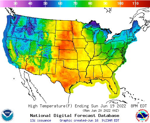
As noted in the forecast for Grand Forks forecast, some oppressive heat is getting ready to surge to the north for Fathers Day and the beginning of next week, It’s already quite hot in the south central US, but after somewhat cool springs, it will be a sudden shot of summer for many in the northern US.
Frequent bouts of severe weather have swept across the region. Strong storms have afflicted every state from South Dakota to Michigan, and even the tier to the south in the last few weeks, indicating for those that didn’t know that the jet stream has lingered over the northern US through much of the spring. The stormy activity and jet’s sag have kept temperatures cool.
Now as we approach the peak sun angle, and the warmth of June, the jet is weakening and starting to wobble. A sharp trough in the Pacific Northwest is going to be a factor in lee troughing in the High Plains, but the troughing will be well ahead of the low, giving a lot of runway to the southerly flow and the warm air that follows. Triple digits may reach the Canadian border.
Strong storms are continuing through the eastern Great Lakes after the latest round of severe weather that started earlier this week in Wisconsin and Illinois, but after today’s (enhanced risk) threat of severe storms In New York, Pennsylvania and surrounding areas, the severe threat peters out. A wonderful side effect of the weaker jet is a lower likelihood of strong storms, and this bout of severe weather looks to be the last for at least a few days.
