It doesn’t happen often in the Front Range, and a city like Cheyenne, but it did early this week. The models did really well with the temperature forecasts, and forecasts were generally pretty good. If there was one thing that everyone got wrong, it was the clouds southeast Wyoming saw overnight. On the back of a strong upper level jet, layers of clouds developed, abutting the higher terrain and trapping warmer air overnight, leading to low temperatures that were warmer than forecast lows both on Monday and Tuesday. Weatherbug was undeterred, and collected the best forecast. Actuals: Monday – High 42, Low 32 Tuesday – High 54, Low 31
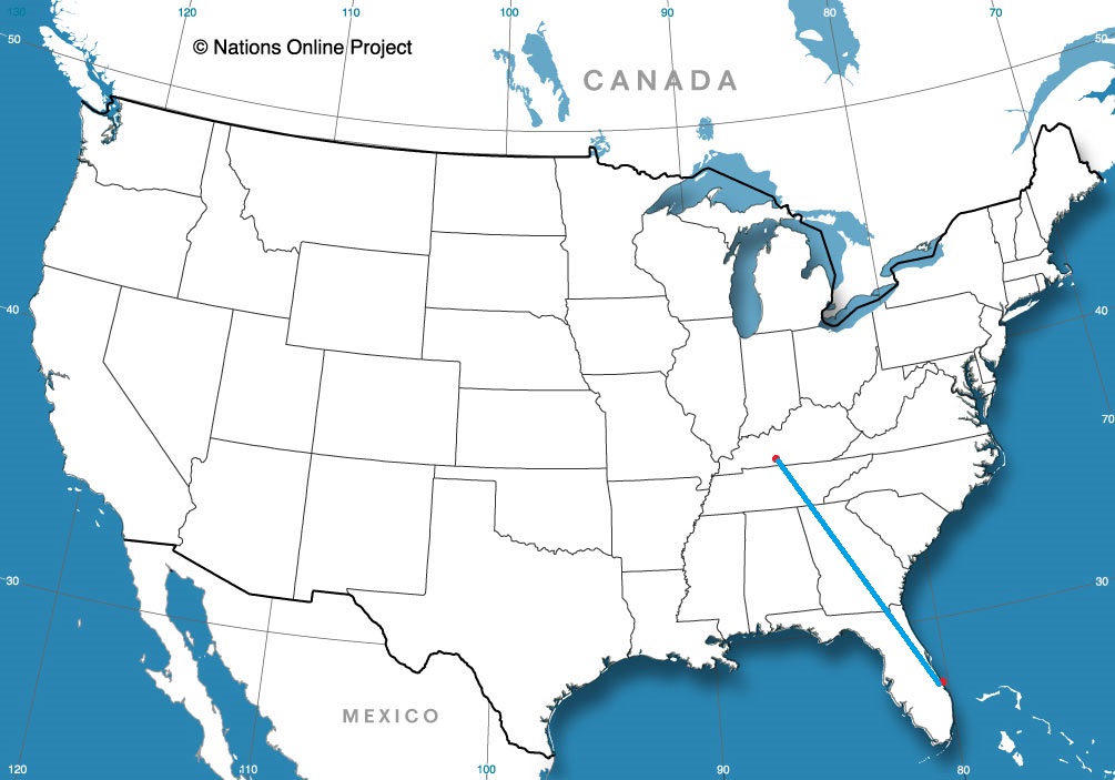
Today’s journey takes us along I-65, one of my old favorite arteries, running from Chicago to Montgomery, but we will end up both north and south of that highway by the time all is said and done. It’s a 2 day trek covering 931 miles. The first day will be longer, concluding after about 502 miles. We’re going to see some weather, so hopefully we make good time outside of the storms.
DAY ONE (Thursday)
Auburn, Alabama
The weather is going to be nice in Alabama tomorrow morning, as warm Gulf air is drawn northward, taking the edge off of the autumn by just a little bit. Nice! Of course, the reason it is going to move to the north is a massive, nasty cold front at the leading edge of a strong ridge of high pressure sinking into the Great Lakes. The resulting boundary will be in our path, starting with a few rogue showers and thunderstorms north of Birmingham, with heavy rain and wind, perhaps even severe, in Tennessee and southern Kentucky. The trailing air mass is going to be cold an dense, so the cut off from rain to clear air will be abrupt. Expect a change in wardrobe if we need to stop anywhere north of Bowling Green, Kentucky, The night will be clear when we call it a night in Scottsburg, Indiana, north of Louisville.
DAY TWO (Friday) While the rain we see on Thursday is going to be a pain in the butt, it will come with a good navigational consequences, Sure, Indiana, Illinois and Wisconsin will be awfully chilly, they will also be sunny and dry. With a fresh bit of snow in Wisconsin, keep those sunglasses at the ready.
I used the current fire map for the LA area as the image in the forecast for Santa Barbara to give a little perspective on the threat in the region as we started to look at the forecast. Even a few days later, the picture is wholly different, with some fires contained, some extinguished and more underway. Santa Barbara did seem to avert the worst of the fires this go around, though there was smoke reported most of the day on Friday as the Getty blaze raged and coupled with easterly winds. Victoria-Weather and Accuweather combined to net the top forecast in the area. Actuals: Friday – High 73, Low 38 Saturday – High 78, Low 40
The month of October has come and gone. North America is bucking the trend of, well, essentially the entire planet, and saw generally a cooler than normal month, but it was marked by some very warm weather type events, like a tornado moving through the Dallas city limits. If anyone is going to handle a topsy turvy. high profile month like October was, the top spot is usually going to The Weather Channel, as it does this month.
Strange that this is the furthest east we’ve been in weeks, isn’t it?
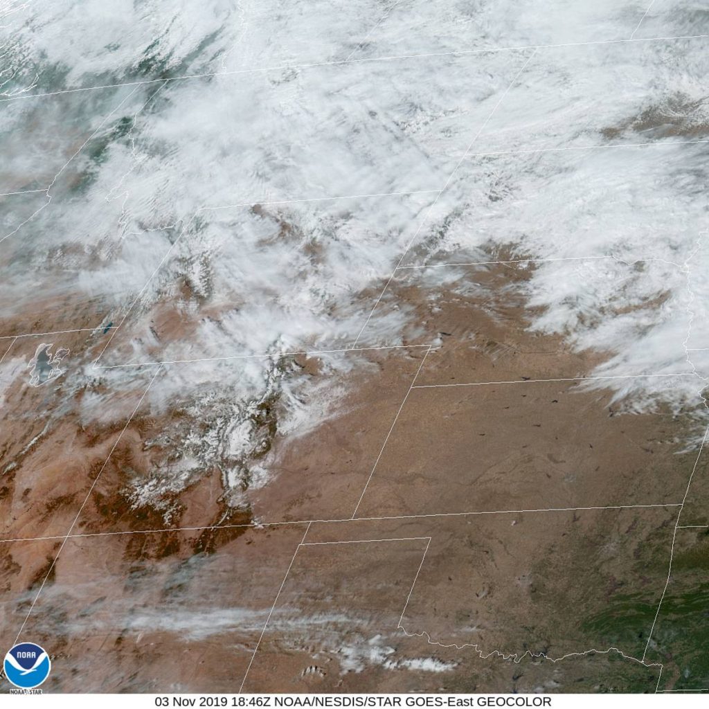
At 1053AM, MT, Cheyenne was reporting a temperature of 50 degrees with sunny skies and a brisk northwest wind of about 25mph in gusts. The off-mountain winds are certainly helping to bolster the warm up this afternoon. There was a weak ridge building in the front range as well, but most of the warm up at this time is mechanical in nature. The upper level pattern is quite static, and a glance at the jet pattern looks to remain unchanged through the beginning of the work week. This means a tight thermal gradient just to the northeast of Cheyenne, which will result and a continuing brisk wind in the region. If the wind continues to be more westerly than northerly, Cheyenne will also be able to sustain some warmer temperatures. Tomorrow – Partly cloudy, High 40, Low 26 Tuesday – Mostly cloudy but warmer, High 52, Low 30
TWC: Tomorrow – Intervals of clouds and sunshine. High 43, Low 27 Tuesday – Sunny skies High 55, Low 29
AW: Tomorrow – Partly sunny High 43, Low 26 Tuesday – Mostly sunny and milder High 55, Low 28
NWS: Tomorrow – A chance of flurries before 11am, then a chance of sprinkles. Partly sunny High 40, Low 22 Tuesday – Sunny, High 54, Low 23
WB: Tomorrow – Mostly cloudy, Colder, High 42, Low 28 Tuesday – Sunny, not as cool, High 55, Low 30
WN: Tomorrow – Partly cloudy, High 40, Low 23 Tuesday – Mostly sunny, High 53, Low 24
FIO: Tomorrow – Partly cloudy throughout the day. High 43, Low 26 Tuesday – Clear throughout the day. High 53, Low 29
A look at the satellite shows some striations in the clouds north of Cheyenne, which are caused by the strength of the jet through those clouds.
Madera was the first of our trio of California forecasts this past week, and was the city the farthest from fire danger. It came down to how temperatures were handled by forecast guidance. Victoria-Weather was off the forecast by one degree on every verifying time by one degree, low every time. That’s just as tough to do as getting the forecast exactly right, I would say. The Weather Channel was off by a couple of degrees at two different times, and V-W and TWC ended up with a tie in Madera. Actuals: Tuesday – High 69, Low 36 Wednesday – High 67, Low 34
Today we take a trip to the Southwest, where the big story the last few days have been unrelenting Santa Ana winds and massive brush fires kicking up from Sacramento to Los Angeles. Will San Luis Obispo be spared from nature’s fury as we head into the weekend?
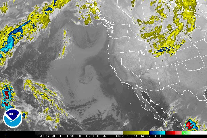
At 950pm PDT, the temperature at San Luis Obispo, CA was 46 degrees under fair skies. High pressure continues to settle in from the Northern Rockies into the Central High Plains, keeping pretty much the entire Western US dry as a bone. Luckily, the Santa Ana’s will be weakening tomorrow after an intense event the last 3 days, which caused the Los Angeles NWS office to issue an Extreme Red Flag Warning, something that’s not in their official lexicon but they needed to convey the danger that 60-80mph winds an 1-5% humidity can cause. While a number of fires popped up, SLB avoided the worst of it, save for some air quality issues. Friday is expected to see some breezy conditions in the morning but settle down throughout the afternoon hours. After that, it looks to be a fairly pleasant weekend with generally subdued winds.
Friday: Sunny. High 81, Low 41.
Saturday: Sunny. High 79, Low 40.
TWC: Friday: Sunny. High 80, Low 43.
Saturday: Sunny. High 80, Low 41.
AW: Friday: Sunny and pleasant. High 80, Low 40.
Saturday: Sunny and pleasant. High 80, Low 38.
NWS: Friday: Sunny and breezy. High 80, Low 41.
Saturday: Sunny. High 78, Low 42.
WB: Friday: Sunny. High 79, Low 42.
Saturday: Sunny. High 80, Low 42.
WN: Friday: Sunny. High 80, Low 41.
Saturday: Sunny. High 78, Low 42.
FIO: Friday: Clear throughout the day. High 78, Low 47.
Saturday: Clear throughout the day. High 79, Low 50.
The Desert Southwest is pretty much clear as clear can be. The nearest significant cloud system is in the Northern Plains.