At the time of the GIF The Weather Channel tweeted out, Super Typhoon Lekima was a category 4 storm, doing a quick two-step around Tarama Island southwest of Okinawa. Lekima was one of two typhoons spinning in the region at the time, but fortunately, Lekima was ultimately the only one that made its way to the mainland, striking south of Shanghai.
Krosa ultimately flamed out, but Lekima did lead to 30 deaths, most of which came in a landslide in the populous and hilly Chinese coastal regions. The remnants of the storm are still moving up the coast, and though it no longer maintains the same levels of intensity, the heavy rains are going to continue to bring problems to many communities.
While Lekima was fierce and scarier still when in tandem with Krosa looming on the horizon, we are in a surprisingly calm period, given the time of the year. The Pacific is generally faster to start tropical season than the Atlantic (which remains remarkably dormant) but aside from Lekima and Krosa, there are no other named storms on the planet.
The Eastern Pacific looks next to give rise to another storm, as models seem to hint at something popping up in the next 10 days, but the Eastern Pacific is usually one of the safer places for tropical development, interception with land is rather difficult.
It’s still a month from the peak of the Atlantic season, and the Pacific Season can often come in waves, but through the middle of August, we look to be n a welcome pause this tropical season, especially in eastern China, where recovery is needed.
We’re deep into the dog days of Summer now, as families are enjoying the last couple of weeks of Summer Vacation before they have to worry about kids going back to school. As expected, conditions are hot and humid across the South, but lately it’s been kicked up a notch above even where locals are accustomed too.
Houston has hit 101 degrees for a third day in a row now, the first time they’ve done that since 2015 when they went 102 102 106 (yikes!). Combined with that has been dew points approaching 80, cranking up the heat index around the metro to 115-120 degrees. Doesn’t look like much relief is on the way either in the coming days.
Pensacola hit 97 yesterday, breaking a high temperature record for the 2nd day in a row. On top of that, potent afternoon thunderstorms then parked overhead dumping over 3.5 inches of rain on the city, also a record for the day. Like Houston, these sweltering conditions are expected to persist for the next couple of days with heat index readings around 110.
Luckily, the residents along the Gulf Coast don’t have to worry about any tropical systems developing over the next several days as the Atlantic Basin is in a pretty quiet pattern right now. However, the intense heat and almost unbearable humidity doesn’t look to relent anytime soon. Stay indoors and cool if you can!
We are getting into the late part of summer, and we start to forget about severe weather (major outbreaks, anyways) and start really focusing on the Tropics. With a light forecasting load, we’ll really be able to dig into the potential storm activity around the world, should it arise.
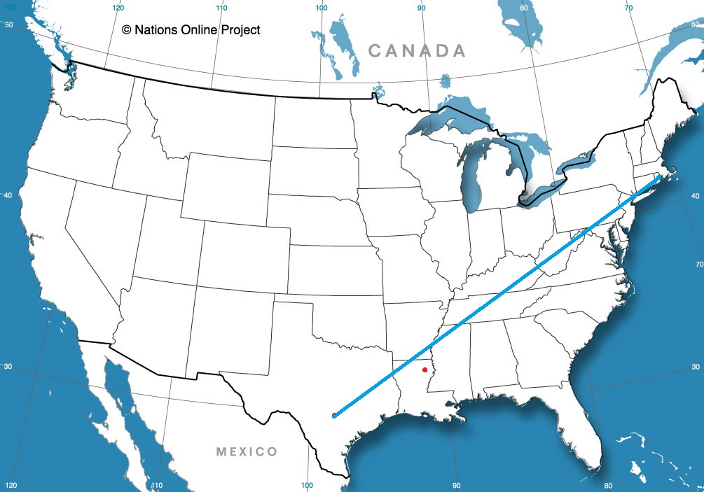
San Antonio, Texas Road Trip from Providence, Rhode Island to San Antonio
Summer time in the forecasting world can be fairly sporadic, and won and lost on the margins, especially if you don’t take into account the tropical season, which has been, this year, fairly dormant. Those margins, though, can be pretty important, particularly in the energy sector, where temperature forecasting becomes crucial, and every degree matters. It may not seem as important to the lay person, but this win for Accuweather, is just as important as any other month.
Thunderstorms generally aren’t as widespread in the northern US as they are in the southeast this time of year, and that is a forecasting lesson I would do well to remember next time. There were storms on Monday in Rochester, just as was universally predicted, but none on Sunday, which only one outlet had left in the forecast. Oops! It was a good forecast all the way around, though, and Rochester was able to enjoy a pretty decent weekend. Actuals: Sunday, High 83, low 64 Monday – .55″ of rain in thunderstorms, High 85, Low 66
I know how great vacation can be, but driving to Florida along the East Coast seems like such a challenge. But then, getting to La Guardia from Bridgeport doesn’t seem like a lot of fun either, so a 2 and a half day trip it is! We’ll meander over the course of 2 1/2 days at a pace of 62.6mph, which as you should know by now, isn’t very fast. We will cover barely over 500 miles a day on days one and two, with the rest of our 1284 mile journey reserved for Saturday.
Punta Gorda, Florida
DAY ONE (Thursday) This is the rare August in which the southeast is somewhat synoptically active. There are a lot of showers and storms in the northeastern Gulf as high pressure sinks into the Carolinas. The daily convection in the southeast will likely not make it further north than Gainesville, which means that if we start early enough, we should stay dry all day. Well, save for the sweat we break out into every time we stop for gas. It’s still going to be hot and humid, until we reach Gable, South Carolina, southeast of Sumter. This blog is very into Sumter right now.
DAY TWO (Friday) High pressure won’t last long in the face of August heat and humidity in the southeast. Alas, a blob of moisture will waft north into Georgia and the Carolinas. We should be sneaking into Virginia by the time it really gets active, but with the moisture wrapping into the eastern exposures of the Shenandoahs and Blue Ridge, don’t be surprised to see some late afternoon haze and clouds, even as far north as Havre du Grace, Maryland, at the northern end of Chesapeake Bay, and our terminus for the day.
DAY THREE (Saturday) Further north, high pressure often has a greater toehold, and that will be the case on Saturday. A wedge of dry air associated with low pressure in Canada will make itself at home in between the moisture blob to the south and that same area of low pressure. It’s going to be a bit of an intense day of driving, as we pass through the southern and eastern parts of the Philadelphia metro, and then right through the heart of New York, but it should be worth it, as Bridgeport is in for a fantastic start to the weekend.
Popocatepetl is a volcano in Mexico. Pocatello was a white hot city in Idaho last week. Popocatello is a portmanteau by a meteorologist who thinks he is funny. Victoria-Weather thought it would be even warmer in Pocatello as July faded to it’s conclusion than it actually was, but we still managed to collect a much needed victory. Actuals: Tuesday – High 93, Low 55 Wednesday – High 93, Low 54
I don’t know what happened to Weather Underground, our traditional source for verification information. This time around, the problem was attribution. They kept reverting back to weather information for Florence when I sought info on Sumter. It’s too bad for us, because we verified better against Florence’s figures. When running the correct verification, Victoria-Weather fell off, and the cooler numbers in the afternoon, with cooler overnight lows gave the win to the trio of Accuweather, The Weather Service and WeatherNation Actuals: Friday (the 26th) High 86, Low 68 Saturday – High 90, Low 64
We are going to sneak close to home tonight, going down to Rochester, the home of the Mayo Clinic.
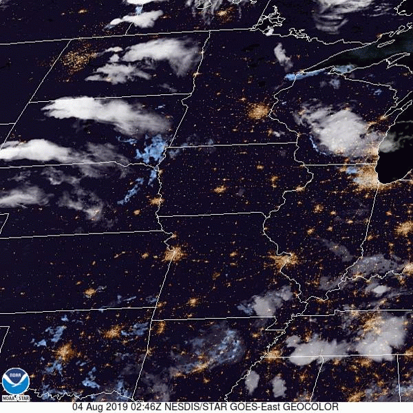
At 1254AM, CT, Rochester was reporting a temperature of 67 degrees with fair skies. Low pressure moving through northern Manitoba is inducing a lot of low level moisture northward, and dewpoints across the region were high. Fog is likely to settle in in low lying areas overnight, particularly given the clear skies. Between the low in Manitoba and the remnants of a system in northern Quebec, there has been a rise in instability in the Upper Midwest, with scattered showers through Wisconsin on Saturday. The Manitoban low will bring some drier air into northern Minnesota on Sunday, and continue through the southern part of the state on Monday. As a result, shower and storm activity will become more voluminous, and depending on the available energy, there is a chance for some severe weather in the Rochester area on Monday. Tomorrow – Isolated showers and thunderstorms, High 85, Low 64 Monday – Scattered showers and thunderstorms, High 82, Low 66
TWC: Tomorrow – Sunny, along with a few afternoon clouds. High 85, Low 65 Monday – Mixed clouds and sun with scattered thunderstorms. Storms may contain strong gusty winds. High 81, Low 68
AW: Tomorrow – Partial sunshine; humid High 84, Low 65 Monday – A strong afternoon thunderstorm; storms can bring flooding downpours, large hail and damaging winds High 82, Low 67
NWS: Tomorrow – Patchy fog before 8am. Otherwise, mostly sunny High 85, Low 63 Monday – Showers and thunderstorms likely, mainly before 1pm. Partly sunny, High 85, Low 66
WB: Tomorrow – Mostly sunny, patchy fog in the morning, High 84, Low 65 Monday – Numerous showers and thunderstorms, high 82, Low 68
WN: Tomorrow – Partly cloudy High 85, Low 63 Monday – Partly cloudy with numerous thunderstorms, High 85, Low 66
FIO: Tomorrow – Partly cloudy throughout the day. High 85, Low 65 Monday -Rain in the afternoon and evening. High 83, Low 69
The timing everyone has for precipitation is all different. Several outlets have rain starting shortly after midnight on Monday, while others don’t have it until the evening. Meanwhile, we have a chance on Sunday. Here is a loop of the day’s satellite imagery, showing the thunderstorms moving through Wisconsin, and fog developing up by Duluth.
Back in mid – July (that’s how far behind I am on these verifications) we looked at the western Michigan town of Muskegon, which was to receive a healthy wallop from a mass of storms moving through Minnesota and Wisconsin. Those storms proved stronger than expected in the Upper Midwest, and generally lasted longer in Michigan than anyone thought. What really surprised all outlets was how little the high temperature was impacted on Sunday the 21st. After a high of 89 on the 20th, it only dipped to 87 for a high on Sunday. Not really a terrific forecast, but not really terrific weather, either. Actuals: Saturday – .51 inches of rain in thunderstorms, High 89, Low 71 Sunday – Thunderstorms reported, not measured, High 87, Low 69