Utica, New York

Today we’re heading to Central NY and taking a closer look at Utica, NY to start the workweek.

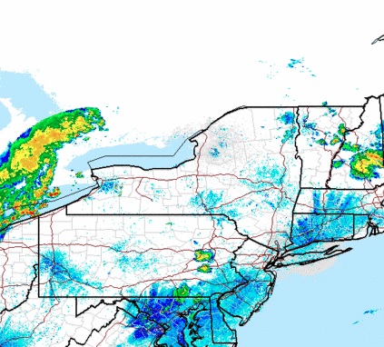
At 1153pm EDT, the temperature at Utica, NY (officially nearby Griffiss AFB) was 68 degrees with a few clouds. The tail end of a cold front is shifting its way through the Northeast, and with it showers and thunderstorms are moving through the Great Lakes. While thunderstorm activity should be winding down by the time activity moves through, there could still be a cell or two that affects the region. Otherwise, general rain showers are anticipated before conditions clear out for the afternoon. High pressure shifts in for Tuesday and brings with it sunnier skies and pleasant conditions!

Monday: Morning rain/possible storm, clearing late. High 83, Low 65.
Tuesday: Mostly sunny. High 81, Low 57.

TWC: Monday: Scattered thunderstorms. High 83, Low 67.
Tuesday: Mostly sunny. High 84, Low 59.

AW: Monday: A shower or tstorm in spots. High 84, Low 68.
Tuesday: Mostly sunny; less humid. High 83, Low 62.

NWS: Monday: Showers then slight chance of storms. High 85, Low 66.
Tuesday: Mostly sunny then slight chance of showers. High 83, Low 61.

WB: Monday: Chance of thunderstorms. High 81, Low 69.
Tuesday: Partly sunny. High 81, Low 59.

WN: Monday: Partly cloudy with light showers. High 86, Low 67.
Tuesday: Partly cloudy with isolated showers. High 85, Low 63.

FIO: Monday: Morning rain then partly cloudy. High 83, Low 67.
Tuesday: Partly cloudy throughout the day. high 85, Low 60.

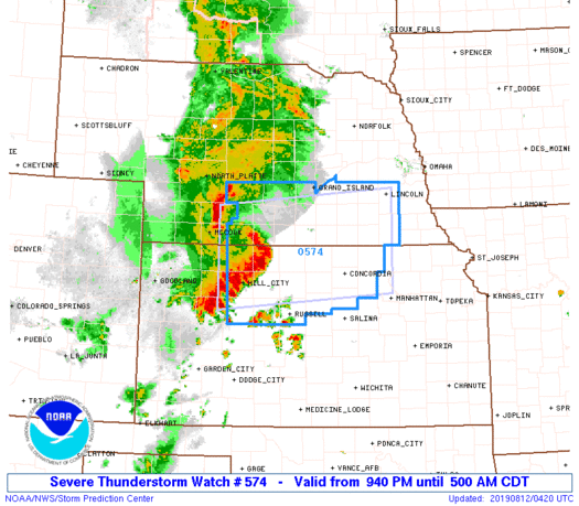
The Utica area is quiet currently, but storms off to the west will be approaching through the morning hours.

San Antonio, Texas

Let’s take a look at the southern part of Texas, where it’s going to be extra hot and extra sticky.

At 751PM, San Antonio was reporting a temperature of 94 with a dew point of 70. Clear skies covered eastern and downstate Texas, though the dry line was active on satellite in the western part of the state. Excessive heat advisories continue through the southern Plains, as high pressure has settled into the area.
The anticyclonic flow is going to dissipate over the next 48 hours, with a return flow setting up along the Sabine River but not any further to the west. San Antonio looks to remain dry if uncomfortably warm to begin the workweek.
Tomorrow – Mostly sunny, High 99, Low 78
Tuesday – Still hot, High 99, Low 79

TWC: Tomorrow – Partly cloudy skies High 99, Low 78
Tuesday – A few clouds from time to time. Continued very hot. High 99, Low 78

AW: Tomorrow – Mostly sunny; very warm High 100, Low 79
Tuesday – Mostly sunny; very warm High 101, Low 78

NWS: Tomorrow – Mostly sunny and hot, High 100, Low 79
Tuesday – Mostly sunny and hot, High 100, Low 78

WB: Tomorrow – Mostly cloudy in the morning, then clearing. High 98, Low 79
Tuesday – Partly cloudy. High 97, Low 78

WN: Tomorrow – Partly cloudy, High 100, Low 79
Tuesday – Partly cloudy, High 100, Low 78

FIO: Tomorrow – Humid and partly cloudy throughout the day. High 98, Low 79
Tuesday – Humid and partly cloudy throughout the day. High 99, Low 78

Here is the satellite, with some puffs developing in west Texas.

Morgantown, West Virginia to Birmingham, Alabama

Today we embark on a 2-day, 677-mile trek through the Appalachians to the Deep South. We could probably get this one in one very long day, but we’re gonna take our time and enjoy some scenery!

DAY ONE

High pressure is found over the OH and TN Valleys, keeping much of the region dry into the Central and Southern Appalachians. A sunny day is expected as we head south out of Morgantown through WV and through western Virginia. Continued pleasant but hot conditions are anticipated for the rest of the day as we end this leg in Knoxville.

DAY TWO

As high pressure continues to control the region, more sunny skies and dry conditions are expected for the rest of the trip. Temperatures are expected to hit the triple digits as we head past Chattanooga into Alabama and eventually into Birmingham, but at least the trip will be dry!

Birmingham, Alabama

As we look forward to the weekend, let’s head to the Deep South and see how the historic city of Birmingham will fare!

At 953pm CDT, the temperature at Birmingham, AL was 80 degrees under fair skies. It’s been nothing short of ridiculously hot over the Southeast this past week as I mentioned a few days ago, and it doesn’t look like it’s gonna go anywhere soon. A strong ridge of high pressure is continuing to sit over the Deep South and will park itself there for another couple of days yet. It will break down a bit on Sunday and a chance of thunderstorms will re-enter the forecast. But until then, it’ll be dry but scorching hot!

Friday: Sunny and hot. High 95, Low 71.
Saturday: Sunny and even hotter. High 96, Low 69.

TWC: Friday: Sunny. High 96, Low 70.
Saturday: Sunny. High 98, Low 70.

AW: Friday: Mostly sunny. High 96, Low 70.
Saturday: Mostly sunny; hot. High 98, Low 68.

NWS: Friday: Sunny. High 98, Low 70.
Saturday: Hot. High 100, Low 71.

WB: Friday: Sunny. High 95, Low 71.
Saturday: Sunny. High 97, Low 70.

WN: Friday: Sunny. High 98, Low 70.
Saturday: Mostly sunny. High 100, Low 71.

FIO: Friday: Clear throughout the day. High 95, Low 70.
Saturday: Clear throughout the day. High 97, Low 69.

The Deep South is extremely quiet tonight, and looks to remain that way as we head into the weekend. Just don’t look at that cluster of severe thunderstorms in MO/NE. Nothing to see here folks!

Colorado sees it’s largest hailstone ever

Last night, massive supercells cropped up in the eastern plains of Colorado. A few tornadoes were reported, though there isn’t much population to really see much of a threat. The hail was more widespread, however, and it was gigantic.

Take a look at the tweeted imge of Colorado’s new largest recorded ahi slone.

The crazy part is that pattern didn’t change much, if at all. Tennis balls fell on the same location the very next night!

Hail stones are caused by strong updrafts, which cause droplets to accrete more and more ice and causes it to become heavier and heavier. The hail stone falls to earth when its weight causes the downward gravitational force to exceed the updraft force. Storms in eastern Colorado have had such intense updrafts so as a half a pound of ice could be suspended. These storms were fueled by the clash of dry air from the west intersecting the heat and humidity in the High Plains.

You can read more about the hail at the Denver Post.

Morgantown, West Virginia

As we head into the latter part of the workweek, lets head off to Appalachia and see what Morgantown is up to the next couple of days!

At 1153pm EDT, the temperature at Morgantown, WV was 70 degrees under fair skies. A weak area of low pressure is traversing the OH Valley region and looks to be the instigator of some afternoon thunderstorm activity. Nothing particularly severe is anticipated, just some good ol’ fashioned summertime thunderstorms. Activity should dwindle down late evening as the system pushes off to the east. Friday looks to be on the dry side with perhaps some isolated shower activity staying up in the mountains to the east.

Thursday: Increasing clouds in afternoon, scattered thunderstorms possible. High 84, Low 64.
Friday: Decreasing clouds in afternoon. High 84, Low 66.

TWC: Thursday: Afternoon thunderstorms. High 85, Low 64.
Friday: Partly cloudy. High 84, Low 64.

AW: Thursday: A strong afternoon thunderstorm. High 85, Low 66.
Friday: Periods of sun. High 86, Low 67.

NWS: Thursday: Scattered afternoon showers and thunderstorms. High 86, Low 65.
Friday: Isolated early morning shower, otherwise mostly sunny. High 87, Low 65.

WB: Thursday: Chance of thunderstorms. High 83, Low 64.
Friday: Partly cloudy. High 84, Low 65.

WN: Thursday: Partly cloudy with scattered showers. High 86, Low 65.
Friday: Partly cloudy. High 87, Low 65.

FIO: Thursday: Partly cloudy, few showers. High 86, Low 62.
Friday: Partly cloudy throughout the day. High 87, Low 66.

Quiet conditions are found around Morgantown this evening, with some shower activity found over southern OH. We can expected some more activity tomorrow but then taper down for the weekend.

Some good news this summer

After several consecutive years of drier than normal conditions, and severe drought and water shortages across California, a robust winter and a long spring have nearly reversed the trend, save for a slightly dry patch over the San Diego area.

Additionally, it doesn’t appear as though the drought will return even late this summer. A break is just what all concerned parties need this summer. Hopefully, it will persist next year as well.

PDS Severe Thunderstorm watch issued for northern Kansas

A watch is issued when a dangerous situation is possible, but a PDS, or “particularly dangerous situation” watch indicates a level of certainty for high end severe weather that should give residents within the bounds of a watch pause. The SPC has issued a PDS Severe thunderstorm watch for Northern Kansas and parts of southern Nebraska, including Lincoln.

Usually, PDS watches are for tornadoes, when supercells are expected to produce large, long lived tornadoes. In the case of this severe watch, that massive line bearing down on Hill City, and ultimately posing a threat for Concordia before dawn, the ongoing threat will be extremely violent straight line winds.

The text of the watch includes a threat for winds of 85mph or greater, while there have already been reports of gusts to 80mph as the squall exited Colorado. This storm is going to rage overnight, which means it will likely take many people off guard. Unlike tornadoes which usually bring sirens, but ultimately pick and choose their way across the countryside, this storm will not trigger warning sirens in every county, despite the risks, and will likely impact more residents. The PDS attribution should make all emergency personnel in the area take notice and be ready to respond as necessary.

It’s going to be a noisy night.

Tallahassee, Florida to Grand Forks, North Dakota

Today we embark on a 3-day, 1,687-mile cross-country trip. However, we’re not going coast to coast, we’re going from the Gulf to the Great Plains! Let’s see what the next few days has in store for us as we make our way from Tallahassee to Grand Forks.

DAY ONE

Quiet conditions are expected for our departure from Tallahassee in the morning. As we pass by Montgomery midday, a few isolated showers and thunderstorms look to develop in the region, but most of that should be off to the east of the route. Dry weather should persist for the rest of the day as we pull into Nashville for the night

DAY TWO

Quiet conditions are anticipated for the start of the second day, though as we head northwestward on I-24 into KY, there could be a couple isolated showers during the late morning hours. We’ll pass by Paducah and head north towards Champaign, with partly to mostly cloudy skies along the route. Dry weather persists throughout the day as we pass Champaign and continue north towards Rockford, our stop for the night. There could be some isolated shower activity as we pull in, but thunderstorms might be seen off to the northwest.

DAY THREE

Low pressure shifting through WI and IL to start the day could make for a cloudy and showery morning as we head north towards Madison. Thunderstorm activity, if it’s already started, should be off to the east so that’s some good fortune for us as we start this long day. Dry conditions are expected through the midday and afternoon hours along I-94 through WI towards the Twin Cities, though don’t be surprised if a late-afternoon shower pops up as we make our way into MN. As we continue along I-94 past St. Cloud towards Fargo, dry conditions are expected once again and remain so for the rest of the trip into Grand Forks!