last week, we looked at a forecast in Yuba City, north of Sacramento. Whenever I think of interior northern California, I think of mountains, trees and milder weather than the inferno to the south. It gets plenty hot in the northern Valley too, though. Yuba City hit 102 on Wednesday, but faced a significant cool down on Thursday. 93! In fact, that 93 was cooler than any outlet had in the forecast. what a relief, right? Weatherbug beat the heat and had a very good score to earn the win. Actuals: Wednesday – High 102, Low 70 Thursday – High 93, Low 64
I recently wrote about the challenge of presenting weather dangers in a clearer manner, and how important it was to clarify the risk represented by much of our sometimes vague terminology.
Another problem is that most consumers receive their weather from the media, and the media does indeed to need to drive viewership. I am of the opinion that people who are watching the news are already in it for the weather forecast, as it will help guide their decisions for the day, but some corporate overseers see it differently.
Meteorologist Joe Crain was recently terminated for espousing the opinion found in the above video. His station’s corporate management insisted upon a certain number of “Code Red” weather days with no real threshold for what that meant. Obviously, that runs counter to the efforts of increasing weather awareness for the every day person.
Overwarning, or in this case overpromoting severe weather is akin to crying wolf. If a Code Red day can mean rain for three or four days, how can the viewer know that Code Red means severe thunderstorms or tornadoes on another day?
But alas, the bottom line is financial, especially when a national corporation owns a local TV station, rather than public safety. While Crain was in the right by most clear thinking opinions, he definitely ran afoul of his employers’ business plan. It’s a blight for all meteorologists.
We are going to sneak on over to the home of the college World Series. This is the rare example of a previously assigned forecast working out with a big event in that town. The blog has only been around for a decade, sheesh.
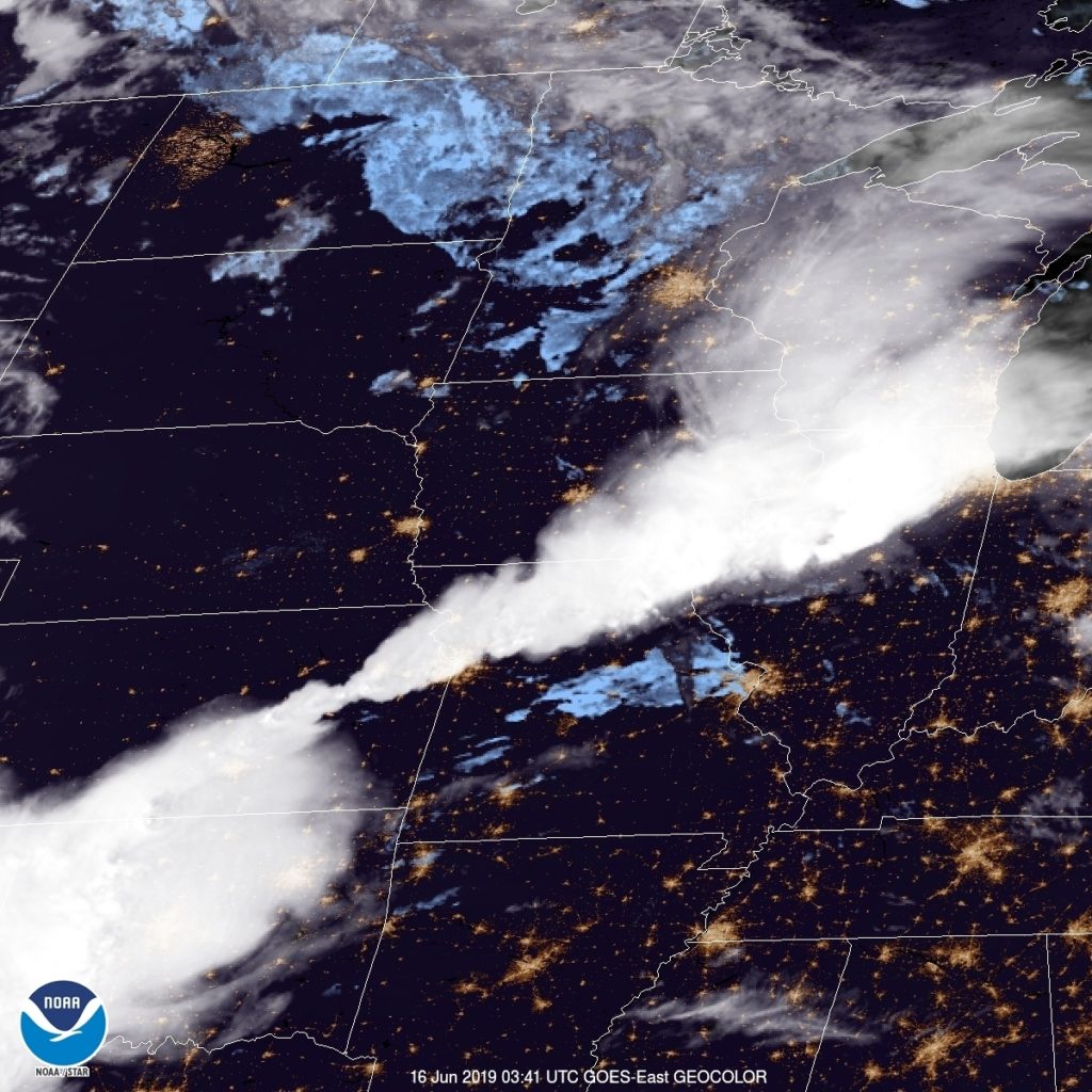
At 952PM, CT, Omaha was reporting a temperature of 7 degrees with fair skies. Clouds associated with strong showers and thunderstorms have pulled into east Iowa, and Nebraska was nearly entirely devoid of clouds. A cold front swinging out of Canada intersected with weak low pressure in Iowa, and the localized circulation was doing an effective job of drawing clear, dry air into the Missouri Valley. Father’s Day looks quite pleasant for Omaha as a result. A surface trough scooting through the Dakotas may touch off some showers in the north central part of the state, however the still lingering Canadian front will prevent moisture from really accessing the trough. Clouds will increase in the evening, but Monday doesn’t look terrible either. Tomorrow – Mostly sunny, High 83, Low 63 Monday – Increasing clouds, High 80, Low 62
TWC: Tomorrow – A few clouds from time to time High 88, Low 65 Monday – Some sun in the morning with increasing clouds during the afternoon. A stray shower or thunderstorm is possible. High 83, Low 64
AW: Tomorrow – Times of clouds and sun; nice High 85, Low 65 Monday – Times of clouds and sun; nice High 80, Low 64
NWS: Tomorrow – Sunny, high 83, Low 63 Monday – A 20 percent chance of showers and thunderstorms after 2pm. Partly sunny, high 80, Low 61
WB: Tomorrow – Sunny, High 84, Low 65 Monday – Partly sunny with a 30 percent chance of showers and thunderstorms, High 80, Low 65
WN: Tomorrow – Mostly sunny, High 84, Low 63 Monday – Parly cloudy with isolated storms, High 81, Low 61
FIO: Tomorrow – Partly cloudy throughout the day. High 83, Low 65 Monday – Mostly cloudy throughout the day. High 79, Low 59
Here is the very pretty satellite for Omaha, which is missing any clouds over eastern Nebraska.
All right! It’s finally time to get a forecast under our belt this month. We’ll do so with a trip to northern California, where last summer the concern was wind and wild fires. It’s been much wetter this year, so let’s hope the fire danger is mitigated.
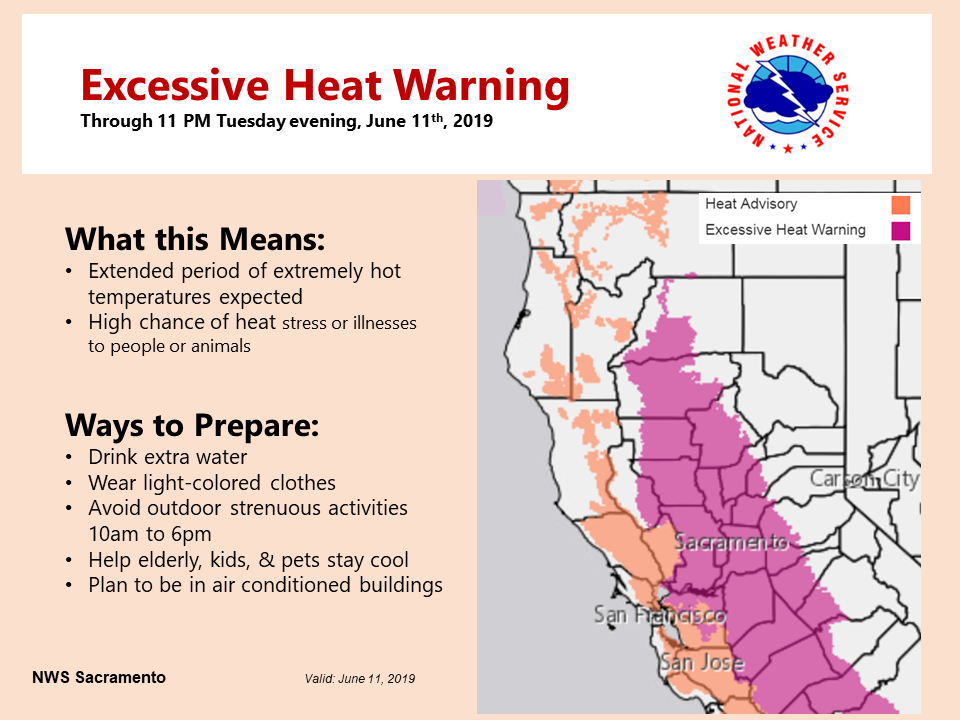
At 758AM, PT, Yuba City was already reporting 79 degrees under fair skies. High pressure dominated the west coast, and it promised to be a hot day in the central Valley. An excessive heat advisory was already in place. There is a weak undercutting wave moving through the north Pacific that will arrive tomorrow, and may bring some high clouds and perhaps a dose of cooler weather on Thursday. The upper ridge will diminish through the period, but the low level thermal ridge isn’t expected to go anywhere, and even if temperatures moderate, it will still be hot. Tomorrow – Fair, High 100, Low 67 Thursday – mostly sunny, High 95, Low 64
TWC: Tomorrow – A few passing clouds, otherwise generally sunny. Hot. High 103, Low 68 Thursday – Mostly sunny skies High 97. Low 64
AW: Tomorrow – Mostly sunny; hot; extreme heat can be dangerous for outdoor activities High 102, Low 68 Thursday – Sunny; hot; air quality will be unhealthy for sensitive groups High 95, Low 64
NWS: Tomorrow – Sunny and hot, High 101, Low 70 Thursday – Sunny and hot High 97, Low 67
WB: Tomorrow – Mostly sunny, High 101, Low 70 Thursday – Sunny, High 94, Low 64
WN: Tomorrow – Mostly sunny, High 101, Low 70 Thursday – Sunny, high 97, Low 67
FIO: Partly cloudy until afternoon. High 98, Low 71 Thursday – Clear throughout the day. High 94, low 65
Hot! Here is a look at the heat warnings, geographically, across northern California right now.
Did you see the wall of dust as it charged toward #Lubbock and @TexasTech today? The dust was picked up by strong outflow from a cluster of severe thunderstorms as they moved toward the city. #TxWxpic.twitter.com/pUHpoXgLX9
This massive, sprawling dust storms are more frequently associated with the sandy deserts of the Middle East, or more locally, the dusty landscapes of the Southwest, but this massive haboob swept into Lubbock, Texas late last week, and was captured by Texas Tech University for all of us to marvel at.
As the Red Raiders noted, the haboob is formed, as they often are, but winds rushing away from thunderstorms, thanks to downdrafts hitting the earth and spreading outward, faster than the storm motion itself. This is a feature that often appears in the desert where the climate is arid and the ground can get dusty, but where instability can be such that strong, but low precipitation thunderstorms can develop. Usually, there is more moisture available than this in West Texas, but on this occasion, we get quite the show.
We’re now into Meteorological Summer (June-August), so it’s no surprise that temperatures are starting to heat on up here across the country. After what seemed like an extremely late start to Spring around here in the Upper Midwest, everything is in full bloom as the temperatures have been pushing into the 70s and 80s lately. Well, today here in the Twin Cities, we officially hit 90! We last hit 90 on September 16th, a span of 264 days! (The record, if you wish to know, is an insane 691 days, Minneapolis went all of 1915 without hitting 90F). Luckily the humidity was kept in check today, with dew points around 60, so it was nowhere close as bad as it could have been.
Where it WAS pretty awful was south Texas. Brownsville hit 104 degrees today, not only setting a record for the date, but setting an all-time record high for the month of June! (103F in 1918 and 2012 previously). However, that was no match for Falcon Lake, TX (also along the Texas/Mexico border), which reached an incinerating 116 degrees! Heat Indicies reached into the 120s in some places given the dew points were in the upper 70s to 80 at some spots. Certainly no good for anybody having to be outside in that.
And it’s not just the US that’s roasting right now. Record heat engulfed Scandinavia, as portions of northern Finland reached well into the 80s, nearly into the Arctic Circle. Some reports are saying they haven’t experienced this type of heat that far north so early in the summer season before. And since most of those locations have homes which aren’t equipped with air conditioning, it’s leading to some miserable nights.
Most likely we’ll see more extreme heat “outbreaks” as Summer plugs along, but we can always hope that they’re short in duration and people take precautions to protect themselves from its effects.
There are so many layers of terminology in meteorology and weather forecasting on top of the scientific definitions of various phenomenon that it’s no wonder there is so much confusion when dangerous weather looms. Part of the problem is a fundamental lack one’s own geography, but also a lot of these terms we use in alarm as meteorology, we take for granted that the general public understands.
The problem is that more often than not, the public does not understand. There are a lot of terms, there are a lot of different levels of concern and there is generally a lot of confusion. One of the disconnects is that meteorologists are immersed in the terminology at all times, whereas the lay person only worries about, say, thunderstorm watches a handful of times a year. I’ve seen too many meteorologists get exasperated with the public, but the truth is, there is culpability on our side as well.
I would invite you all to explore my book, coming out on June 18th, for some definitions on watches and warnings. The short version is that warnings are more immediate, while watches are more precautionary. This section begins on Page 108, if you are so interested.
The Storm Prediction Center is truly our first alert for impending severe weather. Still, their terminology can run afoul of the laypersons intuition. Take a look at the current Day 1 (aka – today) forecast for thunderstorms across the US.
If you are a regular reader of this blog, you might know that a “Slight Risk” (SLGT) suggests a potentially stormy day, while an “Enhanced Risk” (ENH) portends a bit more intensity, but if you aren’t familiar with these definitions, a “slight risk” may seem dismissable, while an “enhanced risk” sounds apocalyptic.
Generally speaking, the outlooks are based on the potential for severe weather to occur within 25 miles of a location. The threshold for severe wind and hail is a 15% chance to be referred to as a “slight risk” which means that roughly, you can expect a severe weather event once every 6 or 7 times a slight risk is issued in your area. Tornadoes have a lower threshold, of 5%, or one in every 20 issuances, to have a slight risk be issued for an area. This is the case today in southern Mississippi and eastern Louisiana.
when a “Moderate” or “High” risk is issued, this should be an advanced notice of a significant severe weather outbreak expected for the day. Usually, this terminology is broadcast by the media. For further information, a visit to the SPC website will give a breakdown of the individual threats. and will even label areas under the threat (10% or higher) of significantly severe weather, by use of hatching in their graphics.
It kills us as meteorologists to hear that there was “no warning” when a catastrophic storm moves through an area, because in our minds, there are often at least three layers of notification before a storm arrives. We must accept the fact that the messaging is not as crystalline for the lay person as it is for us, and attempt to deliver out alerts more clearly. for the time being, I hope that this helps to clarify some of the terminology that exists today.
Between a move and a long vacation, Victoria-Weather wasn’t very active, so as much as I like to laud active months for their clarity in selecting a forecaster, I think luck had more to do with the result than usual. The win was split by The Weather Channel and Accuweather all the same.
Got a long trip from northern CA to the Deep South, covering 2,536 miles, which should take 5 days to cover.
DAY ONE
A broad ridge of high pressure is found over the Great Basin/Four Corners region, which is keeping most of the thunderstorm activity over the Sierras as well as the Rockies in the Four Corners region. Much of the day should be dry and fairly quiet as we travel southward from Redding along I-5 to Sacramento, then along Hwy 99 through much of the Central Valley past Fresno and Bakersfield. Late in the afternoon and evening we’ll cut across the Antelope Valley on 58 before ending our long day in Barstow.
DAY TWO
Going to be spending all day on I-40 as we head east out of Barstow and eventually make our way into northwestern AZ by midday. Some spotty thunderstorms are expected to get going over the mountains as we make our way towards Flagstaff, so by the evening hours some of this activity looks to roll off of them, which could give us a bit of a wet welcome heading past Winslow and Holbrook before ending our night in Gallup, NM.
DAY THREE
Slightly shorter day today, but still a hike across New Mexico as we continue our tour of I-40. However, storms are expected to flare up over the mountains in the central part of the state, so if we don’t get past them in time, we’ll be needing to turn on our wipers as we pass Albuquerque and eventually Santa Rosa. If we can get out ahead of the storms, it should be smooth sailing into Amarillo, TX, where we’ll end the night. Don’t be surprised if some late evening storms roll into town however, might keep us up a bit.
DAY FOUR
Our tour of I-40 comes to an end as we head southeast on 280 out of Amarillo towards Wichita Falls. Unfortunately a boundary settling across the Central Plains eastward is interacting with moisture coming up from the Gulf, and widespread showers and thunderstorms are expected to develop during the midday hours and persist well into the evening. Some thunderstorm activity could get potent as we pass by the Dallas-Fort Worth area, hopefully we’re able to dodge it as we continue onwards and end the long day in Shreveport, LA.
DAY FIVE
Looks like it will be another day of dodging showers and storms as low pressure shifts into the Mid-MS River Valley, increasing the chances of storms from AR/LA eastward into AL/GA as the day progresses. I don’t expect a washout, but you will have to keep an eye on the sky as we push through MS on I-20 past Jackson and eventually into Alabama before finally ending our trip in Montgomery.