
There are so many layers of terminology in meteorology and weather forecasting on top of the scientific definitions of various phenomenon that it’s no wonder there is so much confusion when dangerous weather looms. Part of the problem is a fundamental lack one’s own geography, but also a lot of these terms we use in alarm as meteorology, we take for granted that the general public understands.
The problem is that more often than not, the public does not understand. There are a lot of terms, there are a lot of different levels of concern and there is generally a lot of confusion. One of the disconnects is that meteorologists are immersed in the terminology at all times, whereas the lay person only worries about, say, thunderstorm watches a handful of times a year. I’ve seen too many meteorologists get exasperated with the public, but the truth is, there is culpability on our side as well.
I would invite you all to explore my book, coming out on June 18th, for some definitions on watches and warnings. The short version is that warnings are more immediate, while watches are more precautionary. This section begins on Page 108, if you are so interested.
The Storm Prediction Center is truly our first alert for impending severe weather. Still, their terminology can run afoul of the laypersons intuition. Take a look at the current Day 1 (aka – today) forecast for thunderstorms across the US.
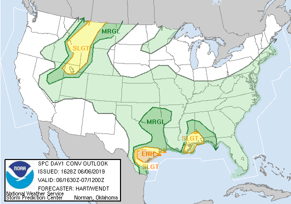
If you are a regular reader of this blog, you might know that a “Slight Risk” (SLGT) suggests a potentially stormy day, while an “Enhanced Risk” (ENH) portends a bit more intensity, but if you aren’t familiar with these definitions, a “slight risk” may seem dismissable, while an “enhanced risk” sounds apocalyptic.
Generally speaking, the outlooks are based on the potential for severe weather to occur within 25 miles of a location. The threshold for severe wind and hail is a 15% chance to be referred to as a “slight risk” which means that roughly, you can expect a severe weather event once every 6 or 7 times a slight risk is issued in your area. Tornadoes have a lower threshold, of 5%, or one in every 20 issuances, to have a slight risk be issued for an area. This is the case today in southern Mississippi and eastern Louisiana.
when a “Moderate” or “High” risk is issued, this should be an advanced notice of a significant severe weather outbreak expected for the day. Usually, this terminology is broadcast by the media. For further information, a visit to the SPC website will give a breakdown of the individual threats. and will even label areas under the threat (10% or higher) of significantly severe weather, by use of hatching in their graphics.
It kills us as meteorologists to hear that there was “no warning” when a catastrophic storm moves through an area, because in our minds, there are often at least three layers of notification before a storm arrives. We must accept the fact that the messaging is not as crystalline for the lay person as it is for us, and attempt to deliver out alerts more clearly. for the time being, I hope that this helps to clarify some of the terminology that exists today.