New York, New York

Heading for the Big Apple for our first forecast of 2024. Absolutely no pressure, right?

At 151PM, ET, Central Park was reporting cloudy skies with a brisk northwest wind and a temperature of 44 degrees. Temperatures across the region were in the mid-40s with the northwest wind, as the area found itself between a large north Atlantic storm and a weaker system in New England. A line of showers extending from Concord, New Hampshire to White Plains was going to pass through the City in the next couple of hours, but given the presence of the offshore feature, not much rain is anticipated.
High pressure will follow the messy system into town, giving the New York area a day to prepare for the first strong winter storm seen in a couple of years. Strong low pressure is going to start organizing in west Texas overnight tonight, and begin sweeping through the Gulf Coast by morning. Saturday morning, the feature will be a formidable system centered over Mobile Bay, getting ready to press north. Meanwhile, a Clipper in the Upper Midwest will be moving eastward, supplying cold air for the pending storm. Precipitation will move in around nightfall. While snow will be persistent in New Jersey, Downstate New York and Connecticut, it will struggle to accumulate initially on Long Island, Staten Island and Manhattan. There could be an inch or two in some parts of the Bronx before Sunday rolls around. Warm air will intrude on Sunday and wash away any snow that does accumulate, but in the evening, things will get more interesting, and accumulating snow is possible even in Manhattan.
Tomorrow – Mostly sunny, High 37, Low 26
Saturday – Clouds increase, with rain and some flakes mixed in late, High 38, Low 30

TWC: Tomorrow – A mainly sunny sky. High 40, Low 28
Saturday – Cloudy skies with periods of rain later in the day. High 39, Low 31

AW: Tomorrow – Sunny to partly cloudy High 39, Low 27
Saturday – Rather cloudy; snow and deteriorating travel conditions at night High 40, Low 30

NWS: Tomorrow – Sunny, High 38, Low 28
Saturday – A chance of snow after 2pm, mixing with rain after 5pm. Cloudy, High 40, Low 32

WB: Tomorrow – Sunny, High 35, Low 26
Saturday – Cloudy. Rain and snow likely in the afternoon. Little or no snow accumulation, High 36, Low 29

WN: Tomorrow – Sunny, High 37, Low 29
Saturday – Partly cloudy with a wintry mix likely, High 41, Low 32

CLI: tomorrow – Sunny, High 39, Low 27
Saturday – Rain Showers, High 37, Low 30

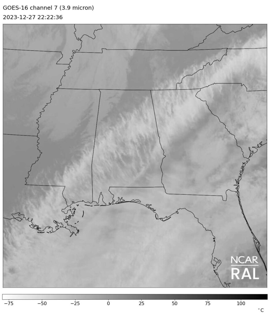
Well, that was a lot. I think the real chance for accumulation will be just outside of the city, and after our forecast period expires, but I can’t well leave it out, right? Here is the rain headed for NYC right now.

New

Exhibition Verification

Only rarely are we able to post a forecast with no bearing on our annual and monthly verification competitions, so when I posted the forecast for Kansas City just a couple of days before the new year, I wanted to do something a little differently. I openly posted the forecast for Kansas City International Airport, while the other outlets had forecasts for the city of Kansas City, Missouri, which is verified downtown. As expected, it was cooler out away from the city, at the airport. The 6 outlets that forecast for downtown were almost all exactly the same in their verification, while my forecast at the airport was a hair removed from the downtown forecasters. Temperature forcing aside, it was still high pressure, and not much existed to sway anyone in any particular direction.
Actuals: (Downtown) Sunday – High 36, Low 30
Monday – High 39, Low 27

Actuals (Airport) Sunday – High 33, Low 28
Monday – High 36, Low 22

Grade: B

Forecaster of the Year

It was an incredible year for Victoria-Weather. We easily had the highest number of “forecast wins” on the year, but that doesn’t mean we also secured the title of forecaster of the year. That comes from consistency, which was not, unfortunately, within our bailiwick this year. Accuweather took until deep into the year to even win a forecast, but they were often near the top of the charts and eventually started getting those wins. Their stability, despite the relatively few peaks, meant they they earned the crown for 2023.

OutletForecast Wins (year)
Victoria-Weather10.83
The Weather Channel5.33
Clime5.33
Accuweather5
Weatherbug4.5
WeatherNation3.5
National Weather Service2.5

Happy New Year, everyone, and I hope you continue to stop here for your weather reads!

Coming together

For the last verification of 2023, all of our forecasters consolidated around the same scores for Macon. There were no trends, to speak of, really. Aside from the Thursday high, every forecast verification had some values warmer and lower than what it turned out to be. That Thursday high was a bit warmer than anyone had projected, but not by much. So with everyone appropriately circling the mark, it just came down to who was the closest the most, and there wasn’t a lot to separate the top from the bottom. Accuweather will get credit for the top forecast for the day.
Actuals: Thursday – High 62, Low 43
Friday – High 50, Low 35

Grade: A-B

Kansas City, Missouri

Kansas City’s larger portion is on the Missouri side of the river, but many of the large suburbs exist on the Kansas side. None of this really helps with our forecast, or dictates a different climate between the towns.

At 253PM, CT, Kansas city was reporting mostly cloudy skies with a temperature of 49 degrees. West-northwest winds were blustery and bringing temperatures down a bit, but without the clouds that are being seen further to the north, it’s still a quite bearable end to the year.
The clouds and whatnot seen in the Great Lakes is a western lobe of a broader trough on the east coast. The cooler air mass is going to continue sinking further south, even without a particular threat for precipitation. This will drive an inactive cold front through Kansas City overnight, leading to a cooler day tomorrow before a stout, clear area of high pressure moves into the middle of the country.
Tomorrow – Mostly cloudy, High 36, Low 25
New Years Day – Sunny, High 37, Low 20

TWC: Tomorrow – Mostly cloudy skies early will become partly cloudy later in the day. High 39, Low 28
New Years Day – Some clouds in the morning will give way to mainly sunny skies for the afternoon. High 40, Low 27

AW: Tomorrow – Colder with times of clouds and sun High 37, Low 29
New Years Day – Mostly sunny High 41, Low 25

NWS: Tomorrow – Partly sunny,  High 36, Low 28
New Years Day – Sunny, High 37, Low 25

WB: Tomorrow – Partly Sunny, High 35, Low 29
New Years Day – Sunny, High 36, Low 26

WN: Tomorrow – Partly cloudy, High 37, Low 28
New Years Day – Mostly Sunny, High 37, Low 25

CLI: Tomorrow – Overcast, High 37, Low 27
New Years Day – Sunny, High 50, Low 25

Those lows in the V-W forecast are a bit lower because we used the information out of the Kansas City airport, which is well outside the city center. Check out the forecast for KCTV-5. There is a distinct focus on the Chiefs football game this weekend.

When will the blowtorch turn off?

It was a warm, rainy Christmas for the middle of the country, and just generally warm in the eastern third. The only areas that got a more traditional Christmas were in the northern High Plains and Rockies, which accounts for a very small fraction of the nation’s population. It’s all part of a month long trend, where temperatures have been warm enough that it’s inescapable that this will be the warmest December on record for a lot of places.

Temperatures to start 2024 look like they will continue to be warmer than normal, even after this first cold intrusion the country is undergoing in what seems like months. The jet is going to become established over the southern US at the same time, though, and this is going to start paying dividends, in the form of temperatures coming in line with normal, or in the southern US, cooler than normal.

The south riding jet is going to allow cool air to filter into the lower 48, but that isn’t the whole story. This jet will be strong and wavy, which means it will be active as well. An atmospheric river, so to speak. The strong areas of low pressure moving from the southwestern US and through the southern tier of states will help in keeping temperatures suppressed. To the north, where it is less likely to cloud over during the day, temperatures won’t end up on the cold side of normal. ‘

Right around normal is still awfully chilly for the northern US, so winter is going to feel more like winter. If that is too much to handle, then rest assured, things are going to get warm fro a lot of the country once again by the end of the month, according to the CPC’s forecast.

Macon, Georgia

Macon is right in the heart of Georgia, and the home of Mercer University. I hope either of these facts might help you with Jeopardy! some day.

At 353PM, ET, Macon was reporting a temperature of 65 degrees with fair skies. Winds were from the northwest, and there was a brisk flow aloft thanks to occluded low pressure over the center of the country. The primary round of wet weather has already proceeded offshore, however the cold air still remains nearer the Mississippi Valley. This postfrontal trough will not reconstitute as a cold front, however, and shouldn’t bring any rain to central Georgia.
The jet structure is robust, as it should be this time of year, and is guiding the low pressure center that brought the rain to town northeastward, and will not allow time for the secondary boundary to organize any precipitable activity. Even so, expect temperatures to continue to drop over the next couple of days, with a chilly Friday on the horizon.
Tomorrow – Mostly sunny, High 58, Low 41
Friday – Cloudy and cooler, High 49, Low 36

TWC: Tomorrow – Some clouds in the morning will give way to mainly sunny skies for the afternoon. High 61, Low 44
Friday – Intervals of clouds and sunshine High 52, Low 33

AW: Tomorrow – Mostly sunny High 61, Low 45
Friday – Cooler with intervals of clouds and sunshine High 52, Low 35

NWS: Tomorrow – Mostly sunny high 60, Low 44
Friday – Mostly sunny, High 51, Low 32

WB: Tomorrow – Sunny, High 57, Low 43
Friday – Mostly sunny, High 50, Low 38

WN: Tomorrow – Mostly sunny, High 59, Low 44
Friday – Partly cloudy, High 51, Low 33

CLI: Tomorrow – Sunny, High 61, Low 39
Friday – Mostly cloudy, High 53, Low 34

A look at the satellite imagery shows some clearer skies rolling into Georgia, behind a very sharp air mass demarcation through Alabama.

A mysterious verification

Sometimes, I cause my own problems. I post something so late that the “tomorrow” of the forecast is actually the “today” of the post time. Sometimes, the issue is that the closest NWS verification facility doesn’t have a 24 hour schedule for observations. Both of these things happened in Huntsville, which made finding the information I needed to properly assess the forecast a bit more challenging. I used Huntsville International for my observations, rather than the Redstone Arsenal, which is closer to downtown, and figured out my own temporal confusions. In end the weather wasn’t particularly dynamic, and everyone assessed an early week cooldown correctly when we put together the forecast Sunday night — er, early morning on Monday. Victoria-Weather, despite our other issues, had the top forecast.
Actuals: Monday, the 18th, High 52, Low 32
Tuesday, the 19th, High 46, Low 25

Grade: B-C

Lebanon, Pennsylvania to Tucson, Arizona

Merry Christmas, everyone! Some people may end up driving over the holidays, and for those people, this one is for you. We’re taking a 4 day trip from the northeast to the southwest. The route covers 2261 miles, at a pace of 68.5mph, which means those days, especially the first three, will cover 548 miles. with the longest, dullest day for Tuesday.

DAY ONE (Sunday)

Lebanon, Pennsylvania

The weather is going to get a little bit interesting as the drive progresses, but for our Sunday, a strong ridge is parked on the east coast, and aside for some very dense morning in many parts of our route, the weather should cooperate. The drive will take us through some un-turnpiked Ohio and Indiana, before we stop in Greenfield, just east of Indianapolis.

DAY TWO (Monday)
It’s probable that we will get underway with dry but foggy skies on Christmas morning, but an advancing cold front will intercept us before reach the Illinois border. The heaviest rain is going to come in eastern Illinois, between the Indiana border and Effingham. The rain will mostly be wrapped up before we hit the Mississippi, however, and blustery conditions will take over in Missouri. The drive from St. Louis to Sampson, Missouri, which is about 40 miles before Springfield, will be windy and increasingly crisp, but dry.

DAY THREE (Tuesday)
It will be dry and sunny for the first time of our drive on Boxing Day, but one variable will be different. It’s going to be chilly as we pass through Oklahoma and head towards Amarillo. The wind will be a bit breezy, but not as bad as on Christmas. Some warmth will start building back in by the time we arrive in Texas/ We’ll take the Panhandle, Texas exit, which is in the Texas Panhandle east of Amarillo.

DAY FOUR (Wednesday)
The last day will be spent mostly in New Mexico, which is a notoriously difficult place to get right. It is higher in elevation than the Plains, a little bit wetter than the desert further west, and all together susceptible to the changing winds. OF course, the biggest fungible variable is temperature, which doesn’t matter unless it’s down towards freezing, which it won’t be. New Mexico won’t be a problem, and Tucson will be delightful.

Tucson, Arizona