I see you, Idalia
from Victoria-Weather

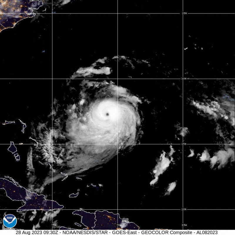
Franklin is a big beautiful storm, with a well developed eye that is mercifully spinning well away from most major interests, save for the air and sea interests of the North Atlantic. He is not getting much attention, because he isn’t going to make landfall anywhere, and will merely work to reroute aircraft and ships.
All that said, he is causing a trough in the mid-Atlantic to slow down, and the rain showers in the Virginias over the weekend dumped enough rain to cause some flash flooding over both states. As Franklin keeps moving, ultimately so will these showers. With luck, Idalia will also steer clear of the region.
Idalia has formed off the Yucatan. There aren’t any major changes vs. what we were looking at yesterday, save for a little bit of acceleration. Expect the storm to landfall on Wednesday south of Tallahassee as a strong tropical storm.
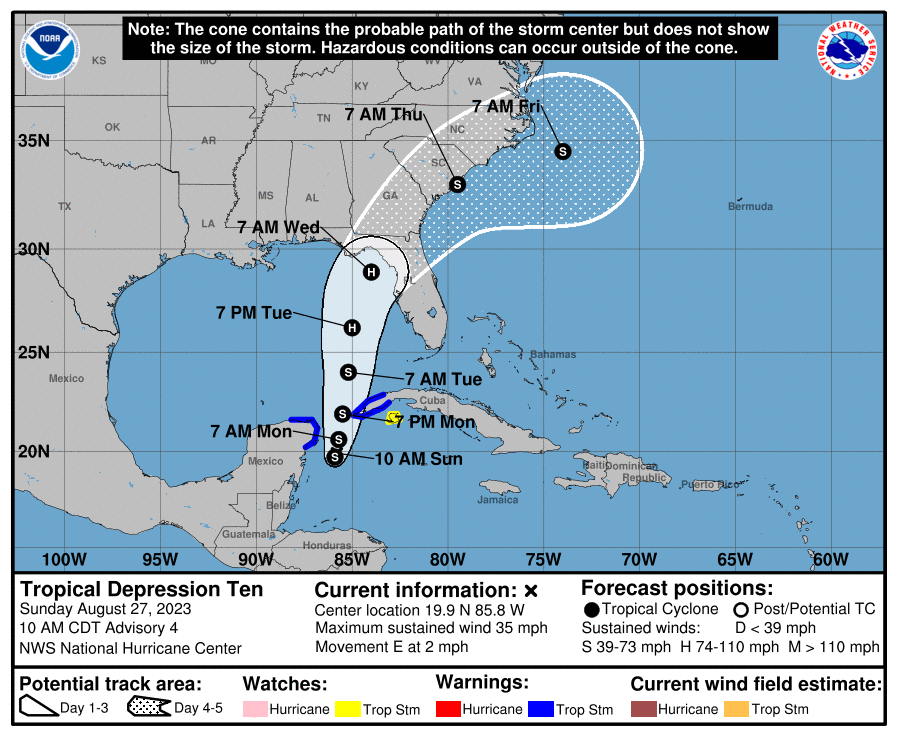
UPDATE 9pm – The latest forecast from the NHC has Idalia landfalling at a Category 2 level. That seems a little high to me, but ultimately, what is most important is that the storms projected landfall is at a pretty low density part of the state. Let’s hope that’s how it ends up.
UPDATE 1115PM – No big changes to Idalia, but the threat for for tropical weather will cut off the inflow to the Midwest. Things should be drier mid to late week in the Mississippi Valley
The first two tropical features to impact the US this year, Hilary and Howard, were well handled. Tropical Depression 10, which is presently hanging out on the coast of the Yucatan, near Cancun and Cozumel, is expected to organize and move slowly to the northeast. The time spent over the Gulf will allow the storm to become a low end hurricane before it moves into Apallachee Bay in the middle of next week,
Much remains to be seen. Fortunately, this isn’t expected to be a major hurricane, but any tropical storm presents it’s own problems.
Update, Sunday 1230 AM – One important factor for TD10’s impact on the States is that it is not forecast to move off shore fully intact, which means it won’t reemerge after the initial landfall. Heavy rain and isolated tornadoes are still going to be a possibility into the Carolinas through the end of next week.
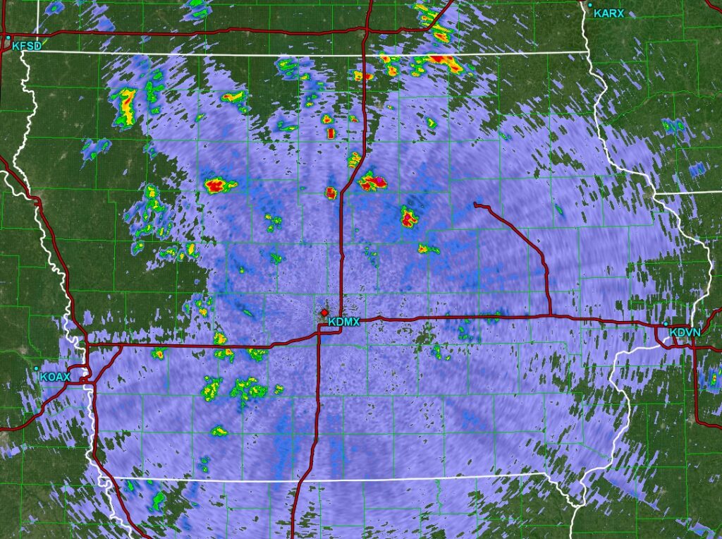
Those are just wind farms showing up on radar
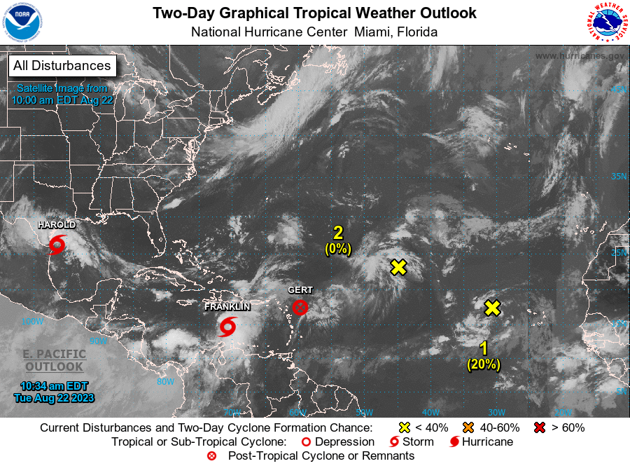
After a year without August storms, and for weeks talking about how quiet the North Atlantic was. we now have three named features in the Atlantic, including Tropical Storm Harold on the Texas Coast, Tropical Storm Franklin south of Hispaniola, and Post Tropical Storm Gert, which is already winding down.
Harold is projected to keep moving due west towards Arizona after landfalling around Padre Island later this morning The Southwest, of course, is already bouncing back from Hilary and likely to see well over their normal allotment of rainfall.
Franklin is moving north, which means rain and potential for flooding across Haiti and the Dominican Republic. Surely not areas that will withstand flash flooding well, but at least Franklin presently isn’t a particularly windy storm, nor will it linger over the island. He may become a hurricane over the north Atlantic, passing near Bermuda.
Gert isn’t necessarily done, but she will wobble around the northern Lesser Antilles for a few days. After that, it’s still a mystery.
These aren’t going to be storms for the record books or anything like that, but business is definitely picking up.
KCRA out of Sacramento shows the 48 hour rain totals for California in this post. Sheesh.
The SPC is great, and I don’t know how easily performed this would be, but I would like to be able to see the population centers by severe region somehow on this map. How do you know that Duluth or Rhinelander are included in the northern marginal risk, because it is hogged by Phoenix suburbs, Tucson and Gulf Coast towns?
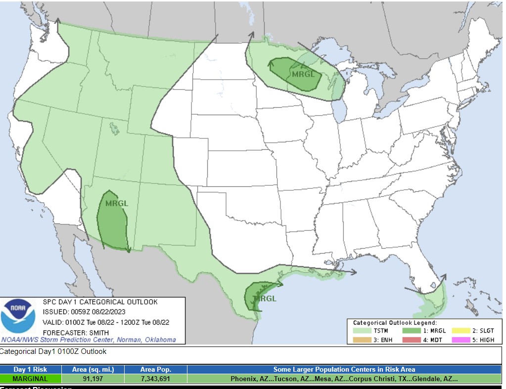
The quibble is minor, but I’ve learned that the grasp of geography is not what it should be.
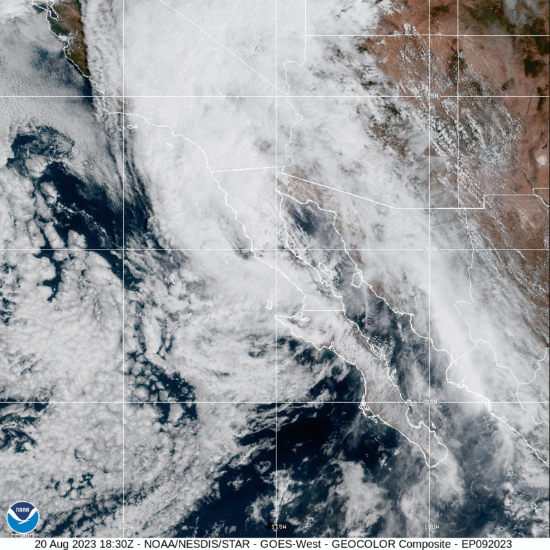
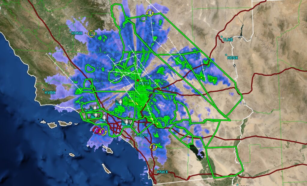
Hilary made landfall earlier today and is now spinning over southern California. There is a lot that makes this different than a tropical storm you would find in the Atlantic, landfalling on that side of the ocean. First is the fact that there is cold water off the Pacific Coast, and the storm eroded quickly before she hit the Baja. Second, there is a lot more terrain in this part of the world than there is in, say, Florida. This means poorer radar availability through the mountains but a more acute threat for flash flooding. Look at all those flood reports and green boxed flash flood warnings if you want proof.
We don’t have the threat for tornadoes like we would to the east, though, and the winds are lower, and there is no storm surge to note. Earthquakes, though…
1200AM update:
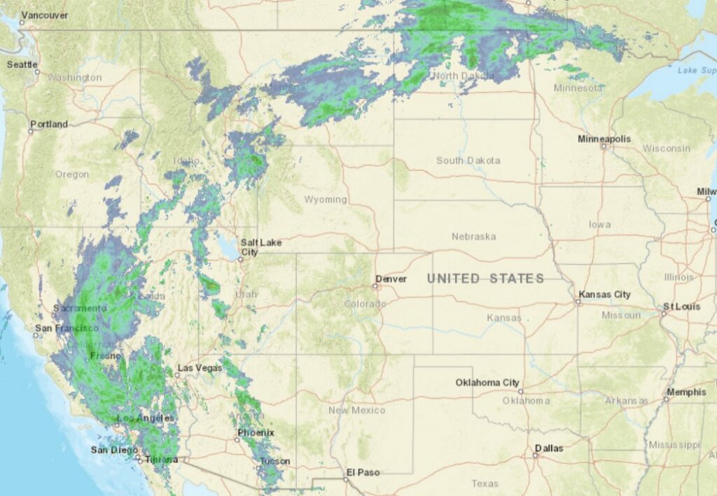
Hilary is pushing moisture all the way up to Sacramento, and then it is catching the upper level flow, and there is a connection that wraps to northern Minnesota.
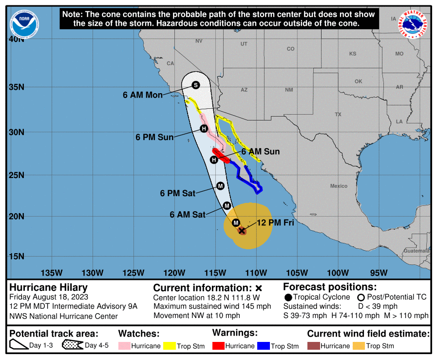
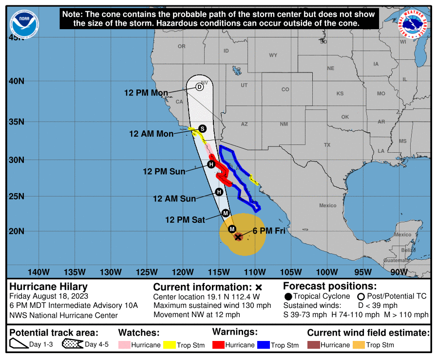
The North Atlantic is finally getting a bit more active, with a few waves that the NHC is monitoring, but right now, the storm that looks the most likely to have the next impact on the US is Hilary, in the eastern Pacific. Hilary at present is a major hurricane, but as she moves north, note that she will start diminishing fairly swiftly. The Pacific is a colder ocean, and her course along the Baja Coast will further blunt the storms intensity. Nevertheless, flash flooding and a few isolated tornadoes are probably going to come for SoCal and western Arizona as next week begins.
8:10 PM Update – The latest projection for Hilary takes her a little bit further to the west, which is bad news for the Southwest. Less time along the coast means that she won’t lose intensity quite as quickly, and there may be a bit more rain, a bit more wind as she moves into the Desert.
130AM Update – Those TS Watches in SoCal are the first to ever be issued for the region.
10pm Saturday Update – Hilary has been downgraded to a Category 1, and will be a tropical storm fairly soon. Like we talk about fairly often with severe weather in the east, this storm will be even more catastrophic because it is coming to a well populated area unaccustomed to tropical weather. The torrential rains will not be well handled, and residents should be prepared to contend with flash flooding.