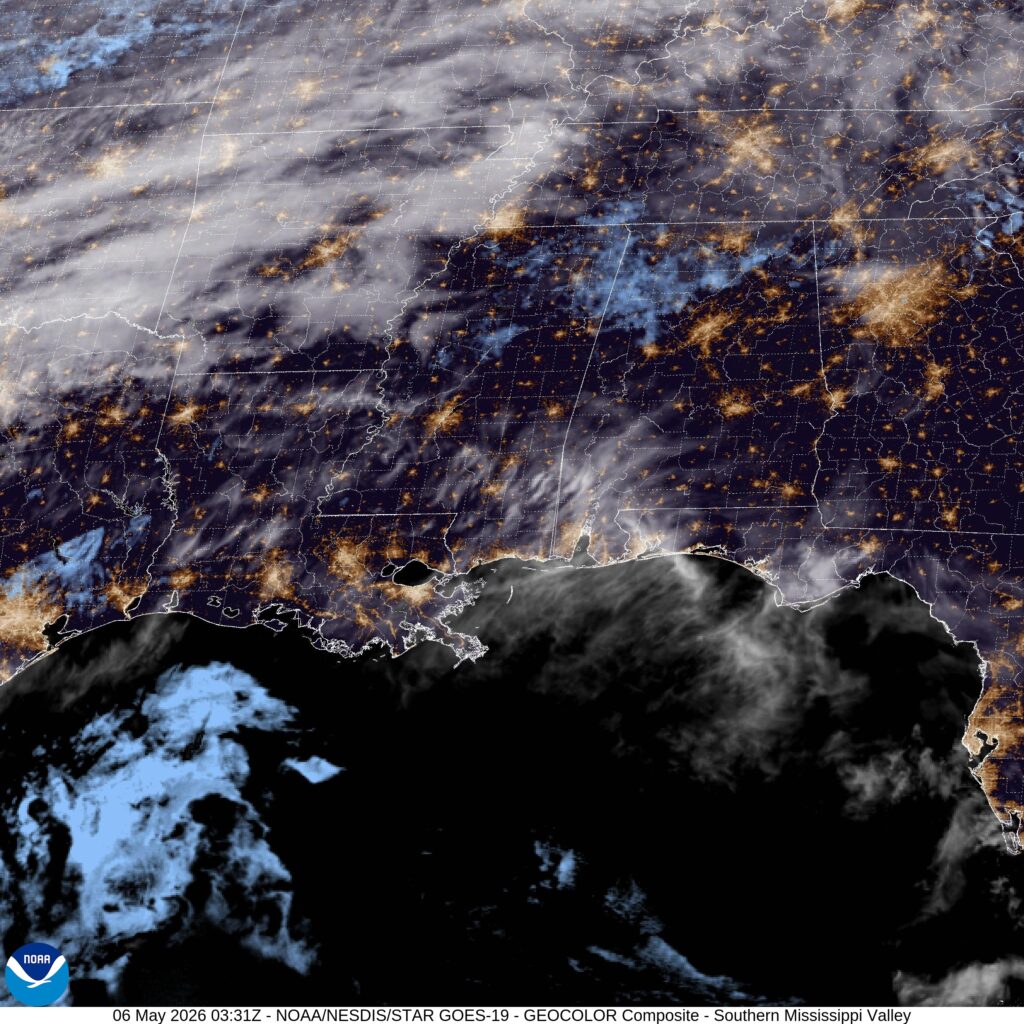
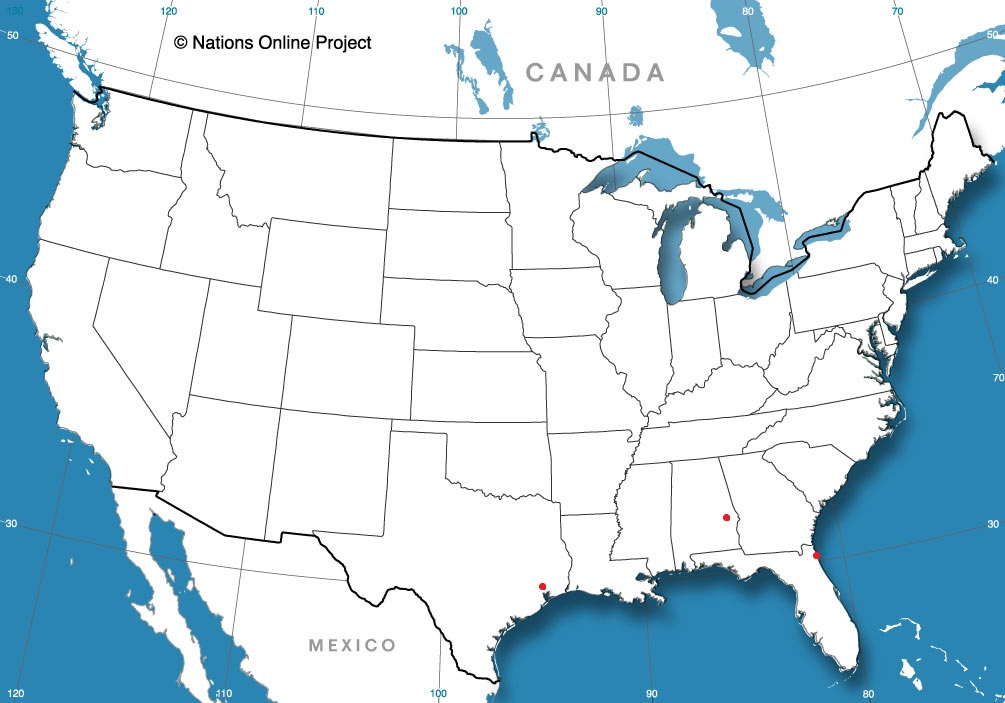
Our first forecast of May was for Alabama. Anniston was awaiting a boundary with showers and thunderstorms. Unfortunately for some temperature forecasts (i.e. the warm ones), clouds preceded the thunderstorms and kept temperatures on the 6th from reaching their maximum potential. Fortunately, this did suppress the severe threat in northern Alabama, which mean Anniston got a good soaking, but avoided the nastiest of it. Accuweather had the forecast of the day, nailing the temperatures on the 7th. Actuals: May 6th, 1.18″ of rain and thunderstorms, High 77, Low 61 May 7th, .18″ of rain, High 71, Low 56
It’s mid-May, and we are suddenly in he severe weather doldrums, as there are a few spots of slight risk moving from the Rockies into the Lower Mississippi Valley over the next couple of days. It seems like the jump from winter weather to rote showers and thunderstorms was pretty abrupt. In fact, the story of last week was snow in Colorado and Wyoming.
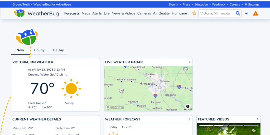
This slower pattern has likely kept traffic down on our favorite weather websites, but if you were there, surely you learned quite a bit about El Nino and pollen. If you haven’t been to visit our friends, you may not have noted the refreshed look of Weatherbug
The new look is definitely informed by their background as a popular app, both on mobile, and as software starting 20 years ago. It’s clean, compartmentalized and easy to distinguish from one piece of information to another. It doesn’t feel as though an app developer tried to build a website, however, which is a very good bit of news. The bug crawling around is fun.
I know we’ve had a couple of font or layout based posts lately, but this is for two reasons. One, it’s quiet out there, but two, the importance of good communication in meteorology can’t be understated. Bad weather often needs immediate action, and that needs to be transmitted clearly. Even if not immediate, threats also need to be clearly addressed, in a manner that is obtainable by people that aren’t necessarily versed in atmospheric science.
Building trust through understanding, legibility and accuracy is important in the quiet times, as well. If we have learned anything in the last several years, it is that science is useless if it can’t be communicated.
We made it through one of the chilliest stretches to start May in a while. There were readings in the Great Lakes and Upper Midwest that suggested that numbers, like morning lows around freezing, or stretches below 50, had not been seen since about 2013. This time of year, that reads more as late winter than late spring.
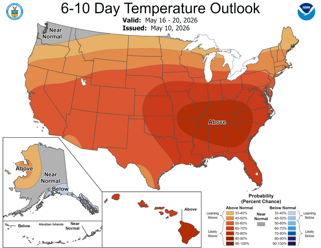
Finally, though, 10, going on 11 days in, the persistent eastern trough is breaking down, and warm air is flowing back north through the Eastern US. And it will persist, with warm forecasts expected for most.
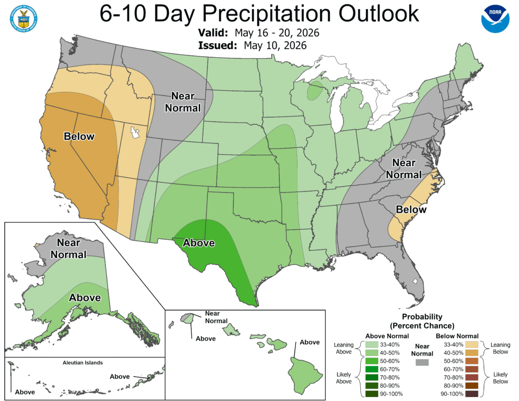
It has also been a dry start to May. April Showers may be through, but May showers are appreciated, too. The jet structure is going to be lifted along the Canadian border, and will be pocked with short undercutting waves. Bundles of energy to bring some precipitation into the picture as well.
You may note that this is not a uniform color scheme. There remains some below normal precipitation in the west, but the good news is, that this typically dodgy area is actually not in a drought this year. They will withstand some dry weather .
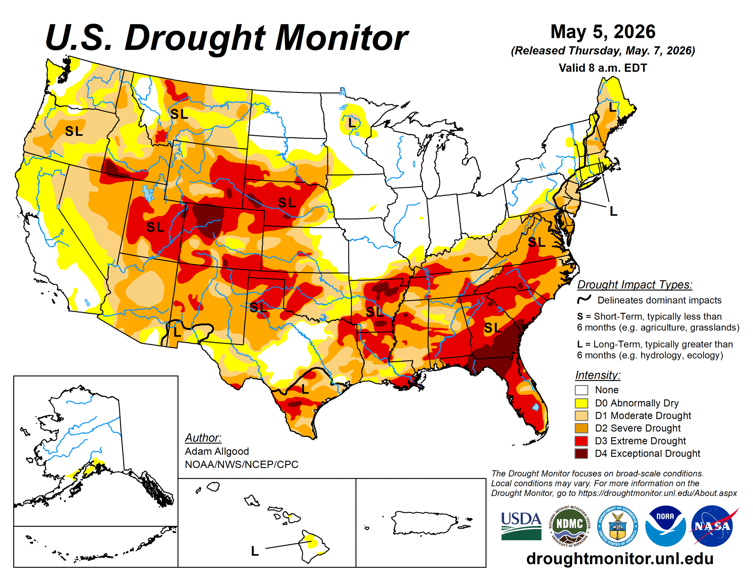
The rain is going to come in places where it is needed. The southeast and northwest remain thirsty, but the Plains are going to warm up, and be satiated for the next couple of weeks.
Our forecast this evening will take us to the South. It’s been cool this May. Does that apply to Alabama?
At 953PM, CT, Anniston was reporting fair skies with a temperature of 67 degrees. The area lay southeast of a cold front sliding listlessly through the Mississippi Valley, which accounted for a southerly flow in the region. The boundary will be reenergized by the daylight tomorrow. The boundary will arrive in Alabama tomorrow, with showers and thunderstorms likely. There is some disagreement on the timing for Anniston, but no doubt that the storm chances are high. The batch of energy will slow down, with clouds and rain hanging on through mid-morning, followed by a much cooler day on Thursday. Tomorrow – Afternoon rain and thunder High 81, Low 64 Thursday – Rain early, then clearing and colder High 73, Low 55
TWC: Tomorrow – Cloudy in the morning then strong thunderstorms developing later in the day. Damaging winds, large hail and possibly a tornado with some storms. High 77, Low 64 Thursday – Cloudy early with partial sunshine expected late. Cooler. High 72, Low 57
AW: Tomorrow – Mostly cloudy and humid; an afternoon thunderstorm High 75, Low 63 Thursday – A brief morning shower or two; otherwise, cloudy High 71, Low 56
NWS: Tomorrow – A slight chance of showers before 10am, then a slight chance of showers and thunderstorms between 10am and 1pm, then showers likely and possibly a thunderstorm after 1pm. Mostly cloudy, High 82, Low 63 Thursday – Showers likely and possibly a thunderstorm before 1pm, then a chance of showers. Mostly cloudy, High 75, Low 59
WB: Tomorrow – Mostly cloudy. A slight chance of showers and thunderstorms in the morning then showers likely with a chance of thunderstorms in the afternoon. High 80, Low 69 Thursday – Showers likely with a chance of thunderstorms in the morning then partly sunny with a chance of showers in the afternoon. High 71, Low 56
WN: Tomorrow – Mostly cloudy with showers and a chance of storms High 82, Low 63 Thursday – Mostly cloudy with showers and a chance of storms High 75, Low 60
CLI: Tomorrow – Thunderstorm High 80, Low 63 Thursday – Light rain showers High 74, Low 55
There is an enhanced risk for severe storms in central Alabama tomorrow with this boundary. The front is pretty sloppy tonight, and things are clear in Anniston.
It’s not been common lately that I’ve been able to get the forecaster of the month post up early in the following month AND it is happening on a quiet weather day. Even more rare is that this month, every outlet had a share of at least one victory… except The Weather Channel. They remain in the lead for the year, but Clime had a very good finish to the month, and it brought them to victory.
I was more skeptical of the chances for rain in Logan earlier this week than most, because it looked like precipitation would be available for the higher terrain, and less so in the dry, urban locales of Utah. Not that I didn’t want it to rain, as this part of the world will take advantage of precipitation when they can. There was about a third of an inch on Monday, while Tuesday saw a few drips, but no actual reports of rain on Sunday. Clime had it’s second very good forecast verification in a row, earning the championship for the day. Actuals: Monday – .32″ of rain, High 51, Low 32 Tuesday – .01″ of rain reported, not measured. High 54, low 30
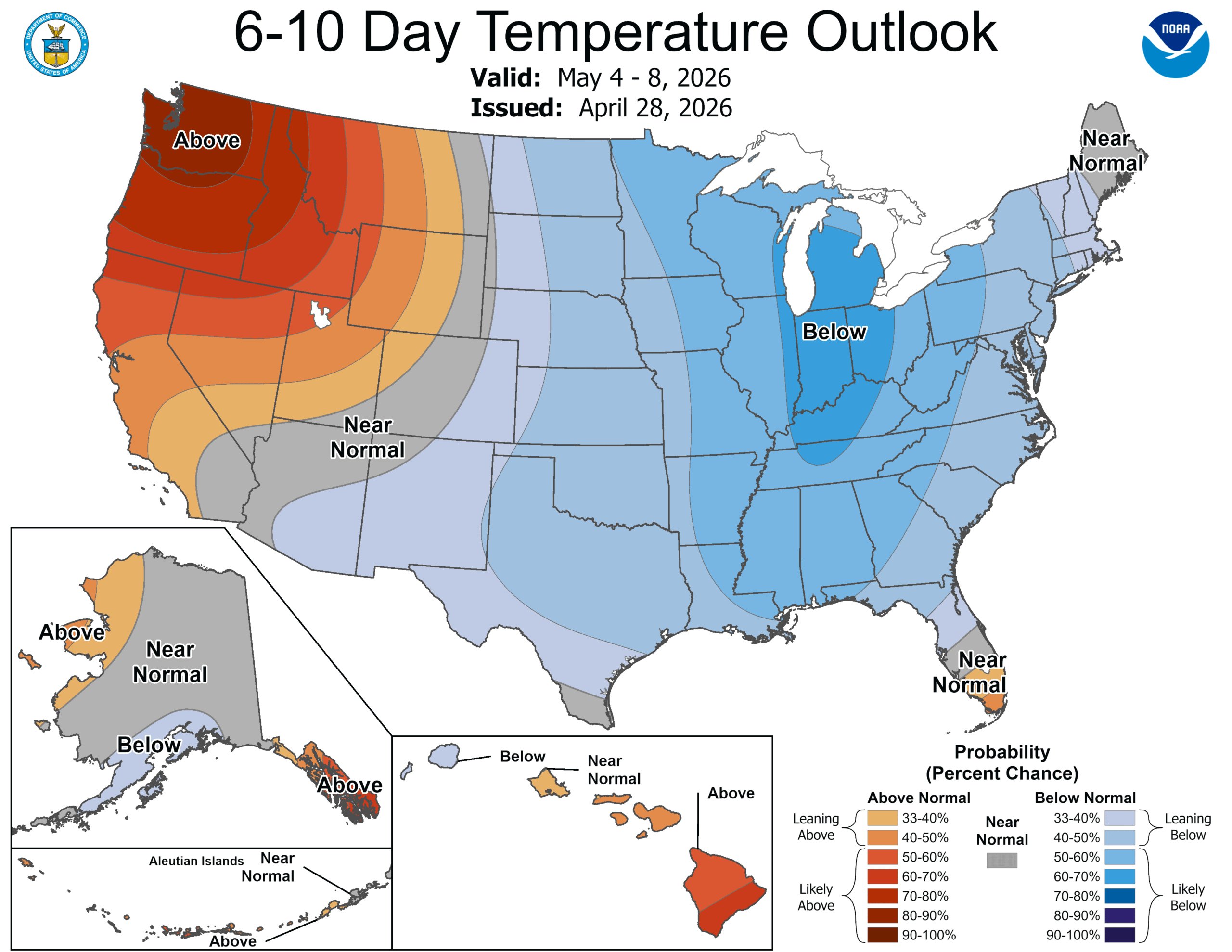
As we discussed, temperatures are staying cool for a lot of the eastern part of the country, and it seems as though we will be hunting warm air, if we can find it.
The CPC has issued their outlook, as of yesterday, for the 6-10 day, 8-14 day and 3-4 week outlooks. This is the 6-10 day outlook, but I assure you, the other two vary only slightly.
The jet flow is going to be bifurcated throughout the next couple weeks, with a strong jet running along the northern Gulf Coast. The Polar jet will be wavering along the Canadian border, often dipping into the US as a trough, ensuring some active weather, however the jet streak to the south will be an effective barrier to moisture rising into the continental US. We aren’t anticipating many soakers around the Great Lakes. This will do wonders for the drought in the southeast, though.
Even with successive waves from the northern jet, it’s really just seasonal thermal forcing that is going to break down the feature to the south and start allowing warmth and moisture back to the north. This isn’t expected to happen until around the 11th, though, which is why we have such a lengthy stretch of below normal temperatures East of the Rockies. It’s still nearly two weeks out, but the action of the northern jet by the 11th tells me that it won’t suddenly get hot in the northern tier, with ongoing showers and storms remaining likely, which will keep temperatures a little cooler if the showers are too widespread
If you are a fan of warm weather, this forecast is a bummer. If you are a storm chaser, this is also a bummer, as this should put a damper on what is historically one of the most active storm periods on the calendar. If you live on the West Coast, you can ignore everything above and enjoy the beach.
Our forecast for Brownsville was for hot, humid days over the weekend, which was expected to lead to some morning fog, especially on the coast. Brownsville is further inland, but even there, the atmospheric moisture was so thick that the condensate was registered as .01″ of precipitation on Saturday. It was still plenty hot and plenty humid in the afternoon when the fog was burned off. There was a three way tie among our most unexpected trio: WeatherNation, WeatherBug and Clime. Actuals: Saturday: .01″ of precipitation, High 88, Low 75 Sunday – High 90, Low 78
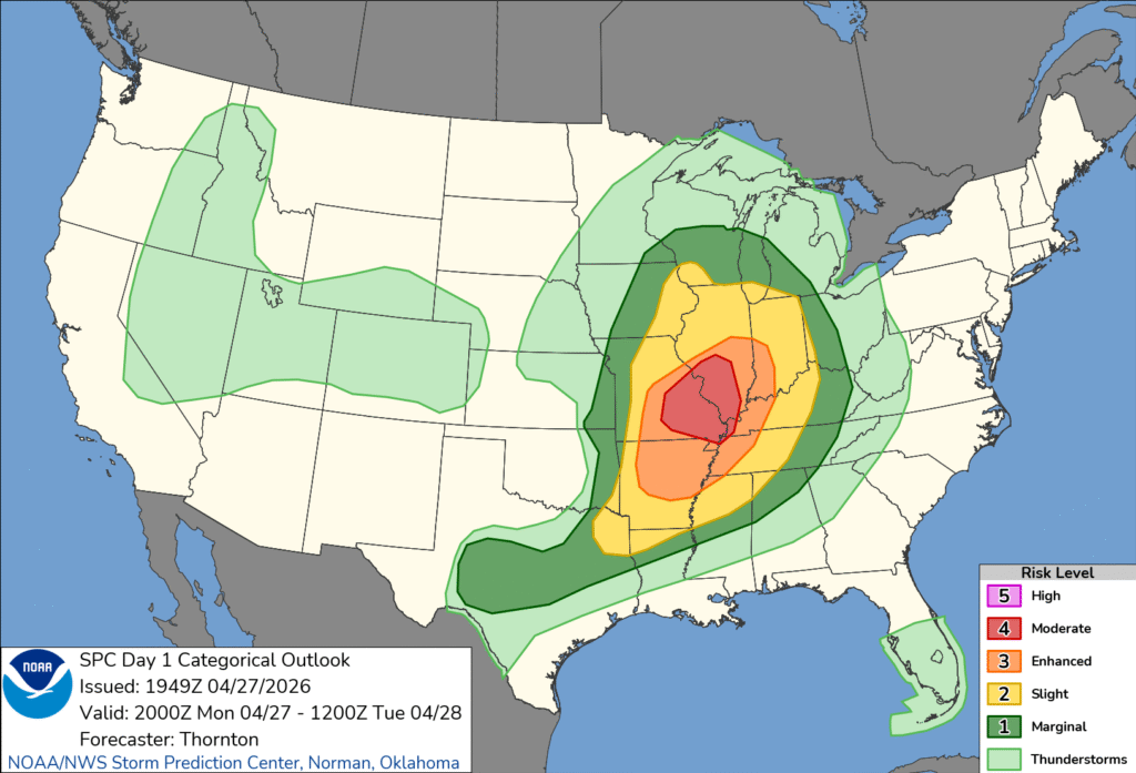
Just after sunrise on April 27th, the SPC elevated the thunderstorm forecast for southeastern Missouri to a moderate risk. A deep upper level trough was generating a strong area of low pressure in the Plains that was feasting on the chaos of colliding air masses. Cold and Canadian with tropical and maritime. The helicity in the atmosphere meant tornadoes were likely.
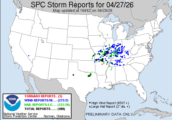
There were indeed several tornadoes from Missouri to Indiana, with a great deal of damage wrought by straight line winds. The tornadoes were embedded within a line, and at some point, it becomes a bit academic as to whether damage is caused by winds or tornadoes.
The changes to the SPC and the deeper set of information within the convective outlook are new features to the thunderstorm season. I wanted to take this specific example to look at what the SPC released, and see what factors best correlate to the outlook that is provided. First, here is the outlook, issued in the early hours on Monday.
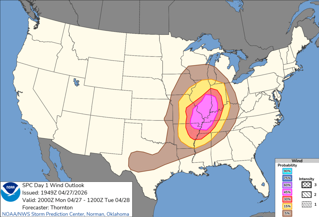
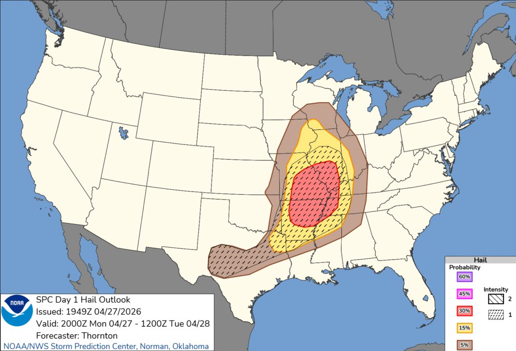
As a bit of background, the change that was recently made to the storm hazard maps added a storm intensity rubric to go along with the probability guidelines that had been a part of those maps before. Take a look at the wind and hail maps to get the idea.
So, you can see there was a high probability of strong wind, and a lower probability of hail, but the hail in the forecast was expected to be larger. We can also see that neither the high probability of severe wind, or the expectation of large hail defined the moderate outlook boundaries. That’s not particularly surprising. That the significant hail in central Texas didn’t lead to a higher outlook than a marginal risk in central Texas surprised me, though.
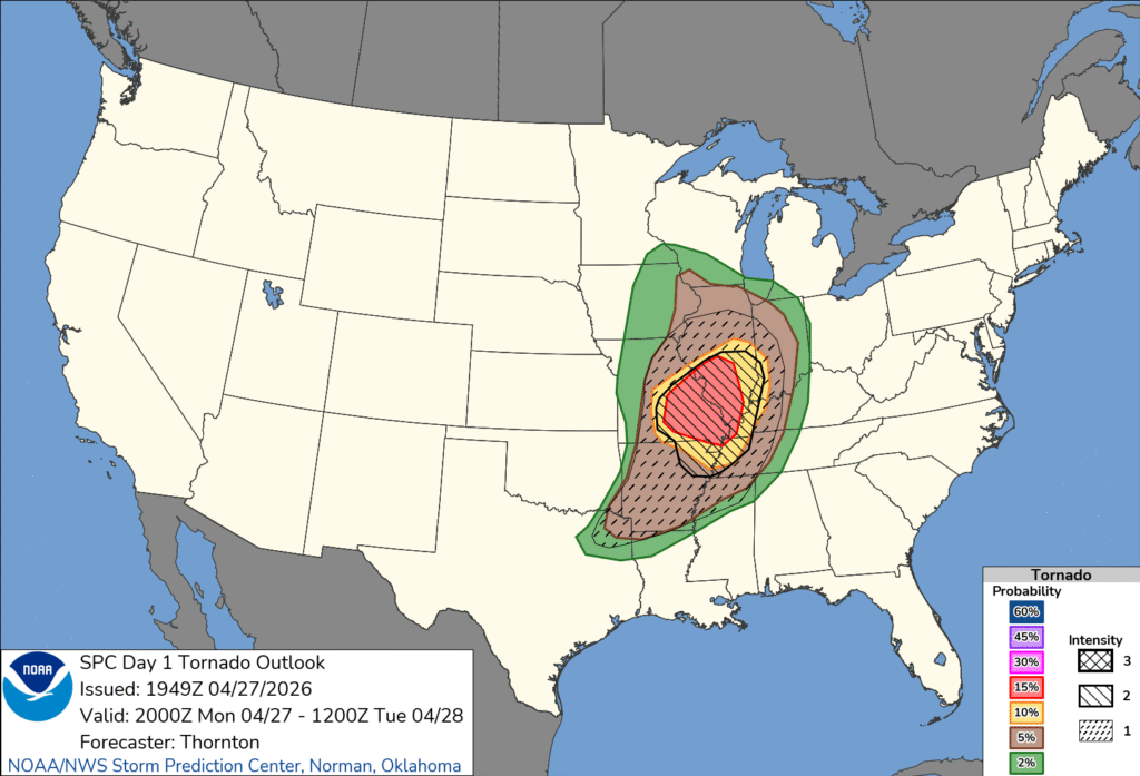
Moderate and high risk events generally need a threat of tornadoes, so let’s look at the tornado outlook issued at the same time as the full outlook.
The threat for strong tornadoes is only designated on the charts as 1, 2 or 3, and the probability of a tornado within 25 miles of a spot is more well defined. Perhaps it is no surprise, then, that the moderate hugs the 15% chance of a tornado risk. I’m sure it didn’t hurt the case that the forecast was a level 2 on the intensity scale, either.
For what it’s worth, here is the break down of severe reports.