I couldn’t think of a very good one liner about Bowling, Green or even the Corvette Museum in the city of Bowling Green, not that “good” is usually our qualifier. I just wanted to get to the point: We had a decent enough day forecasting in a couple of sunny days in Bowling Green last Wednesday and Thursday, which allowed for a pretty good baseline for these forecasts. It was Weatherbug, who had at least 12 hours of perfect forecasting over the forecast period, that earned a forecasting victory. Actuals: October 11th, Hough 70, Low 44 October 12th, High 79, Low 51
We’re taking the rare 2 1/2 day trip that doesn’t once leave the Central Time Zone. The route will cover 1281 miles at a pace of 64.6mph, which means the full days will cover about 517 miles, leaving a pretty easy day to conclude the trip. Here’s hoping the weather along the route is just as easy.
DAY ONE (Friday)
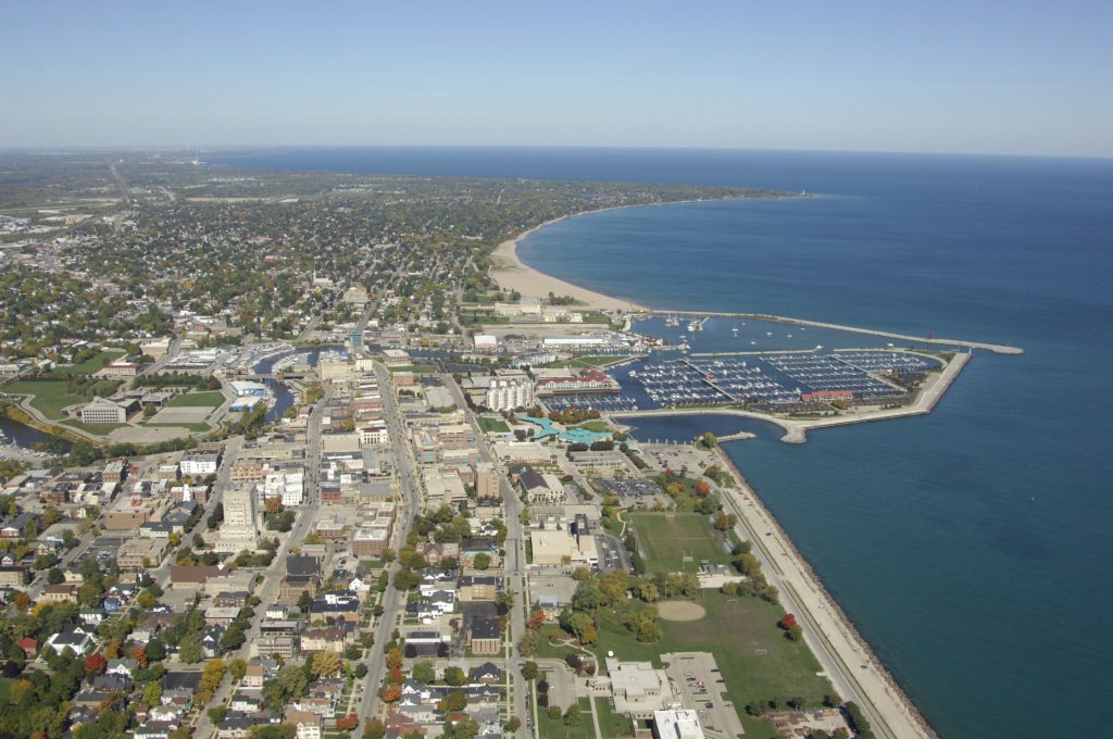
Racine, Wisconsin
Our first day of our drive will be a fine lesson in Midwest driving. We’ll slice through Illinois and southeastern Missouri, including Chicago, as well as a raft of farm country in between. Low pressure will be just recently departing Wisconsin, but will still be spinning over Michigan as we depart. There will certainly be some overcast through Chicago, but cool and crisp northwest winds will begin to force their way in as we pass through Champaign. The sun will be out through southern Illinois, though it may be breezy. We’ll pop into Missouri and reach the Bootheel town of Caruthersville to conclude the first day of our trek.
DAY TWO (Saturday) A late season ridge will be building back into the south central US over the weekend, with temperatures giving everyone a reprieve before the real winter air starts getting ideas. For our purposes, mostly sunny skies are going dominate the drive from Caruthersville through Arkansas and south to Lufkin, Texas, where we will spend our wild Saturday night.
DAY THREE (Sunday) Hurricane Norma is going to spiral back into the Mexican Coast over the weekend, and will have her work cut out for herself, attempting to navigate the Chihuahua Desert. There will be an onshore flow as a result of the churning environment in the northern US and enhanced by Norma’s trek across northern Mexico, so our half day through east Texas is likely to be cloudy, with a few spots of drizzle possible, especially after we’ve arrived in Victoria.
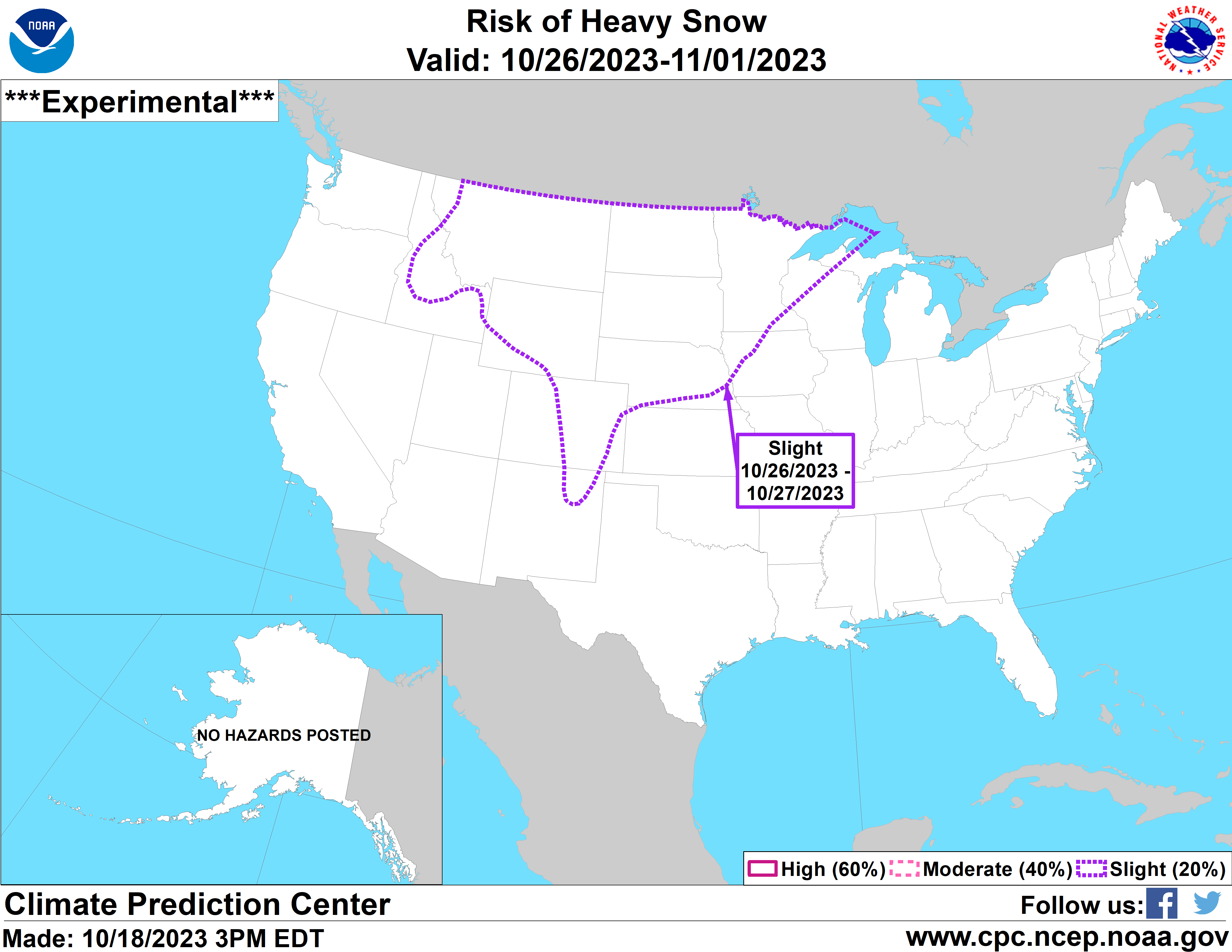
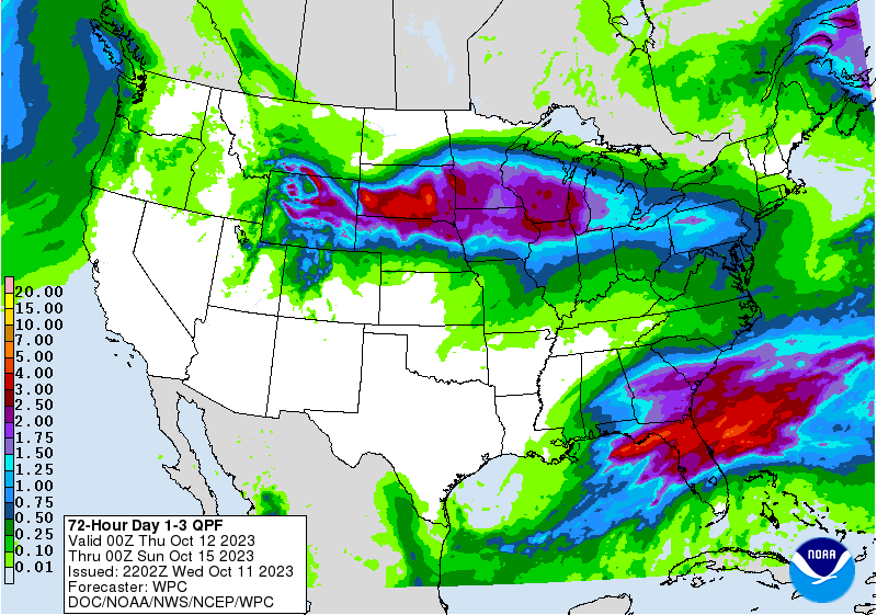
While this is indeed a map that exists, it is well into the future, and even then, only a “slight” Could there be some spots of heavy snow, particularly in the peaks on the western side of this outlook area? Sure. Am I particularly concerned for Omaha, Bismarck or the Twin Cities? I am not.
Victoria-Weather is forecasting for Victoria, Texas, and one might wonder if we have a home field advantage. I can assure you that we do not. Victoria-Weather is named after my home town of Victoria, Minnesota. Slightly different climates.
At 1051AM, CT, Victoria was reporting a temperature of 64 degrees with clear skies and a brisk northerly wind. This will surely keep temperatures cooler for the Gulf Coast this morning. the wind is based on a surface flow, however, and high pressure is blanketing the middle of the country. Flow aloft is fairly stagnant, and cold air will not be actively imported as winds start to subside this afternoon. A weak, quick hitting trough is developing in the lee of the Rockies, and will be moving northeast towards the Upper Midwest. The flow in the region will not alter much, thanks to sluggish jet flow in the region, but Victoria may see a little bit of a rise in humidity as the Gulf opens to the feature to the north. Tomorrow – Mostly sunny, High 75, Low 49 Wednesday – Warner, a bit stuffier, High 81, Low 56
TWC: Tomorrow – A mainly sunny sky. High 77, Low 45 Wednesday – Mainly sunny. High 85, Low 53
AW: Tomorrow – Pleasant with plenty of sunshine High 77, Low 41 Wednesday – Plenty of sunshine; breezy in the afternoon High 84, Low 49
NWS: Tomorrow – Sunny, High 76, Low 46 Wednesday – Sunny, High 82, Low 53
WB: Tomorrow – Sunny, High 73, low 48 Wednesday – Sunny, High 82, Low 55
WN: Tomorrow – Sunny, High 76, Low 45 Wednesday – Mostly sunny, High 82, Low 53
CLI: Tomorrow – Sunny, High 76, Low 45 Wednesday – Sunny, High 83, Low 53
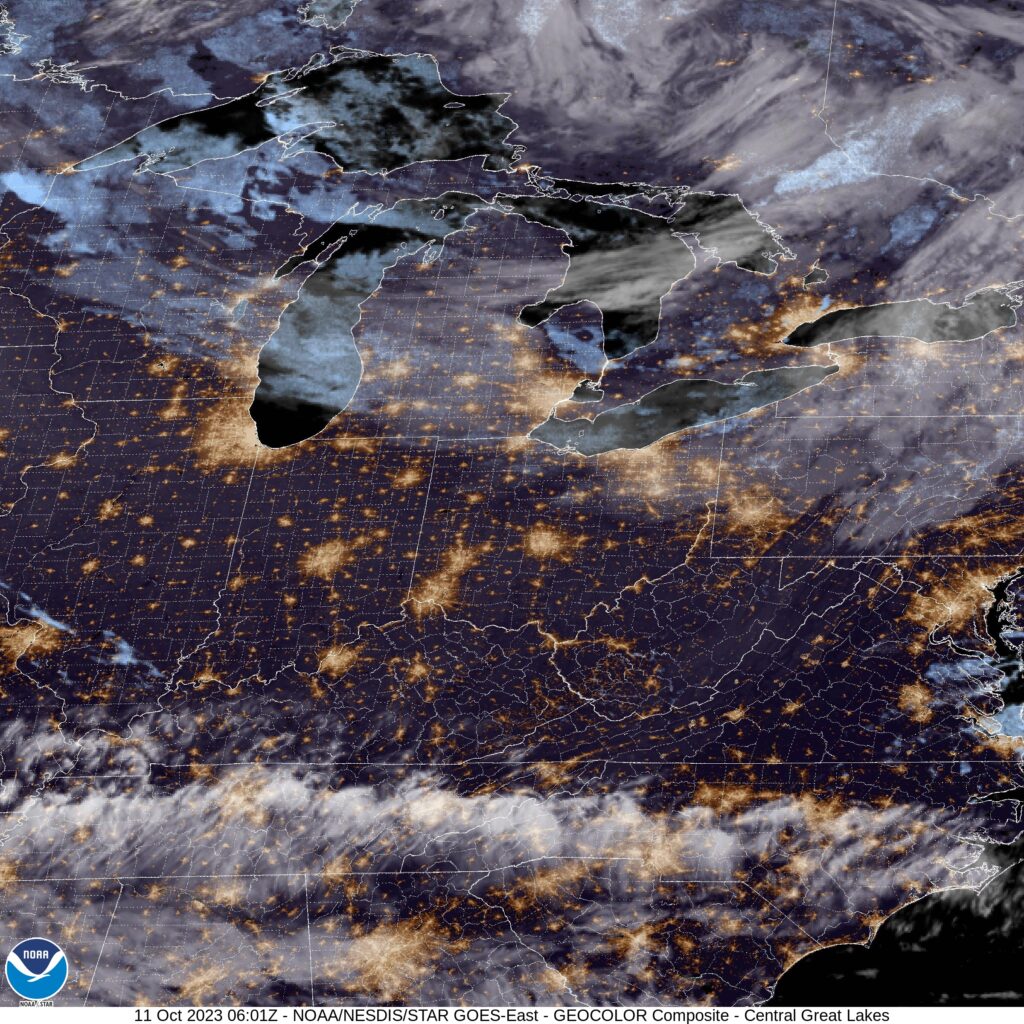
Those are some chilly morning lows for as far souh as Victoria is. The clouds over the Gulf certainly depict the vigorous off shore flow that is being observed. The rippling of the clouds parallel the coast, with nothing on land tells the story.
It had been a minute since we had composed a forecast before we put one together for Evansville. I mused that I hoped we remembered how to do it. Our forecast was fine, but it was difficult to improve on the near perfection of The Weather Channel and Accuweather. They had the same forecast, which paid dividends, because aside from the high temperature being 1 degree too cool on Saturday, the forecast was spot on. Granted, accuracy should be at its best with sunny weather forecasts like we saw in southern Indiana, the forecasts were nevertheless commendable. Actuals: Saturday – High 64, Low 45 Sunday – High 67, Low 40
Racine is nestled between Chicago and Milwaukee as part of the well populated stretch of lakeshore around Lake Michigan. It’s going to be a rainy couple of days for a lot of people. Is Racine going to be one of those locales?
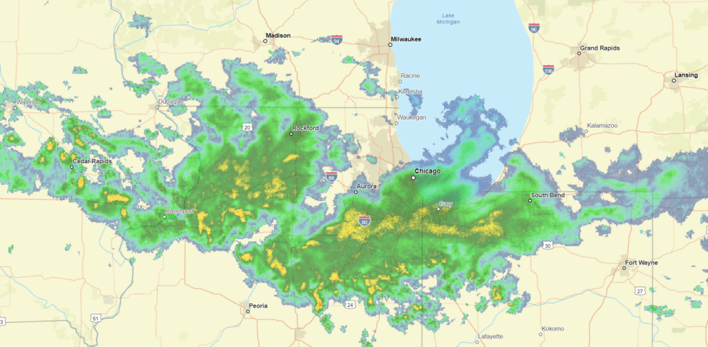
At 1153PM, CT, Racine was reporting a temperature of 56 degrees with overcast skies. There was a smattering of rain showers moving west to east through northern Illinois, with some showers spilling north into Wisconsin. The coverage of rain in southern Wisconsin will only increase, as the rain is associated with a long, ranging warm front extended from a deepening system in the Plains. Racine will exist in the warm sector for a brief time after the warm front passes through Thursday evening, and before the cold front arrives around midday on Friday. The front will potentially bring a bit of severe weather to Chicagoland, and I wouldn’t rule it out in Racine, either. The cold front will be gusty, and the tight rotation of the nearby low pressure could lead to some short lived funnels in the area. The primary concern, ultimately, will be rain, which will accumulate to several inches over the course of the storm, and depending on the intensity of thunderstorms. Tomorrow – Rain early, ending late, High 57, Low 54 Friday – Rain and some thunder in the afternoon. Breezy, High 58, Low 52
TWC: Tomorrow – Overcast with showers at times. High 58, Low 54 Friday – Windy with rain likely. Potential for heavy rainfall. High 58, Low 54
AW: Tomorrow – Breezy with rain; the rain is much needed due to drought conditions High 58, Low 55 Friday – Windy with periods of rain, some heavy, and a thunderstorm; the combination of fallen leaves and rainfall can lead to slick roads High 59, Low 53
NWS: Tomorrow – Showers likely, mainly after 3pm. Cloudy, High 58, Low 52 Friday – Showers likely, then showers and possibly a thunderstorm after 2pm High 60, Low 54
WB: Tomorrow – Cloudy. Chance of light rain showers in the morning, then light rain showers likely in the afternoon. High 56, Low 52 Friday – Breezy. Light showers likely in the morning then rain showers and a slight chance of thunderstorms in the afternoon, High 55, Low 53
WN: Tomorrow – Windy with rain showers likely, High 58, Low 53 Friday – Windy with rain showers and scattered storms, High 59, Low 54
CLI: Tomorrow – Drizzle, High 57, Low 52 Friday – Drizzle, High 57, Low 52
Clime is really underselling this one, aren’t they? You can tell Racine is in for a grimy couple of days, with temperatures stuck in the 50s for 48+ hours. Here is the evening’s radar picture.
During the most recent forecast, I mentioned a couple of features headed for the headlines this week. First, a system moving through the northern Plains, which incidentally may bring about enough cold air to bring snow as far east as the Nebraska Panhandle. Second is the remnants of Tropical Storm Lidia, and we all know how soggy tropical features can be. That northern feature might even have more rain, at least over the US.
UPDATE: Great news! The threat for snow is looking less than we expected earlier. Still going to be plenty up in the mountains.
It hasn’t been nearly as cloudy as some had in the forecast for Bowling Green. Only the big airports are reporting clouds, and only because their vertical observations get higher. It’s still quite clear that all the warm air is in the Plains. It’s only in the 60s.
Hey, weren’t we just forecasting in Indiana the other day? It will be interesting to see what can change in just a couple of days.
At 1053PM, CT, Bowling Green was reporting a temperature of 47 degrees with clear skies. The cooler regime that has embraced the Great Lakes and Ohio Valley in the wake of Philippe on the east coast has remained in place over Kentucky, an the clear nights will only serve to make things even chillier. Two features bear watching that will bring an end to the crisp weather. The first is a strong fall system emerging in the High Plains, and the second is crossing Mexico. Hurricane Lidia, a Pacific storm will move through the northern Gulf towards the Florida Panhandle over the next 24 hours. The warm front associated with the High Plains system will drive warm air northward through Kentucky, but the remnants of Lidia will intercept any Gulf moisture before it reaches Bowling Green. Tomorrow – Mostly sunny, High 74, Low 43 Thursday – Partly cloudy, High 79, Low 55
TWC: Tomorrow – Overcast. High 74, Low 43 Thursday – Sunny skies. High 82, Low 53
AW: Tomorrow – Nice with partial sunshine High 77, Low 44 Thursday – Partly sunny and warm High 82, Low 53
NWS: Tomorrow – Mostly cloudy, High 76, Low 44 Thursday – Sunny, High 79, Low 53
WB: Tomorrow – Mostly cloudy, High 72, Low 44 Thursday – Sunny, High 79, Low 53
WN: Tomorrow – Mostly sunny, High 77, Low 46 Thursday – Mostly sunny, High 79, Low 54
FIO: Tomorrow – Mostly cloudy, High 75, Low 44 Thursday – Sunny, High 82, Low 56
Clouds are encroaching from the south, but aren’t to Bowling Green quite yet.
It’s a little too soggy this weekend in New England, what with Philippe and existing rain showers in the area, but the cold, dry air behind the system that Philippe is merging into is going to be perfect for accelerating the change in colors. If you get some clear air, it will be perfect for leaf peeping.