Can I keep up this accelerated posting pace? I think it can be done, at least until the next vacation. Where are we forecasting for?
Tyler, Texas
Road Trip from Oxnard, California to Tyler
Sioux Falls, South Dakota
Napa, California
from Victoria-Weather

Can I keep up this accelerated posting pace? I think it can be done, at least until the next vacation. Where are we forecasting for?
Tyler, Texas
Road Trip from Oxnard, California to Tyler
Sioux Falls, South Dakota
Napa, California
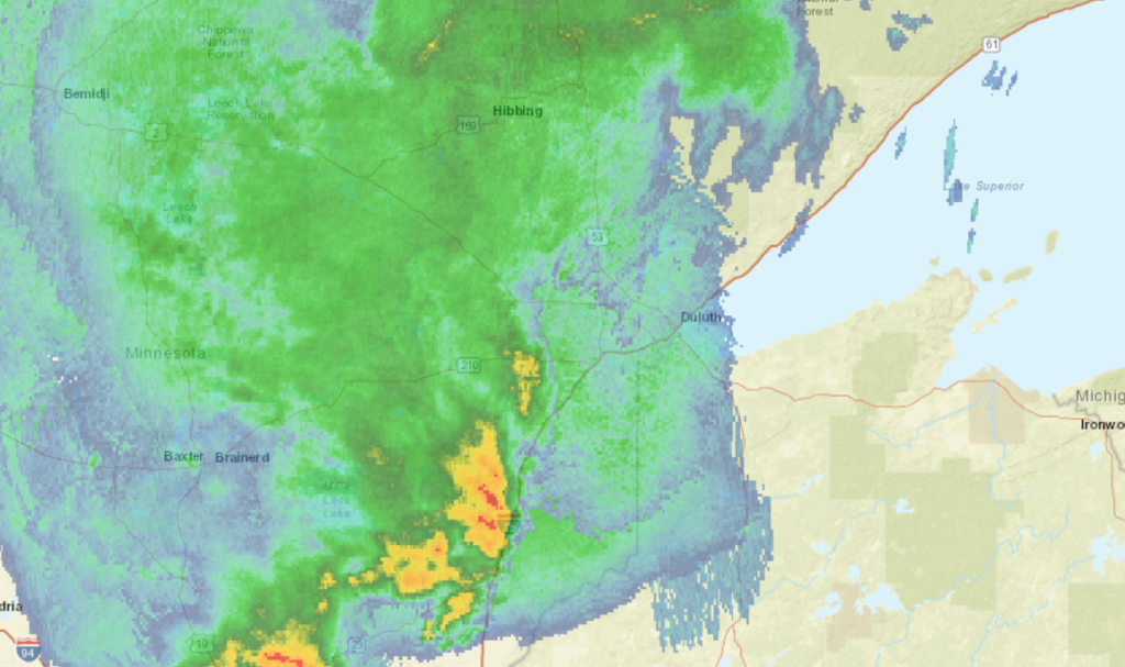
Duluth is one of the most underrated cities out there, in terms of culture, activity and overall beauty. It’s a real treasure on Lake Superior, and frankly feels a little out of place in Minnesota.
At 1155AM, CT, Duluth was reporting overcast skies with a temperature of 52 degrees, and rain. Much of northern Minnesota was caked in rainfall, thoruhg a line of thunderstorms from Moose Lake to St. Cloud was also progressing to the east. A perturbation along a rising warm front was more active, it seemed, than expected, but a warm up to the south and west of Duluth promised another ominous day of convection in Minnesota and the Dakotas.
Short range models indicate a clearing later this afternoon, which would provide for a warmer afternoon. Additional strong thunderstorms will emerge in the Red River Valley in the early evening, but whatever comes from those will not reach Duluth until close to midnight. There is a threat for some gusts with these storms, but the real danger is on the other side of the state. The jet is north to south and will direct the parent low that direction. As a result, behind the front will be substantially warmer than a typical May cold front. This will lead to a bit more instability, and clouds are likely Friday, and a post frontal trough could bring a bit more rain on Saturday.
Tomorrow – Partly to mostly cloudy. Rain and thunder before dawn, High 73, low 49
Saturday – Partly cloudy, chance of some afternoon rain, especially away from the Lake, High 71, low 50
TWC: Tomorrow – Intervals of clouds and sunshine (Early storms), High 65, low 45
Saturday – Sunshine and some clouds. A stray shower or thunderstorm is possible High 69, Low 51
AW: Tomorrow – Mild with clouds followed by a brightening sky (early storms)High 67, low 44
Saturday – Mostly sunny High 69, Low 51
NWS: Tomorrow – Mostly cloudy, then gradually becoming sunny (early storms) High 70, Low 49
Saturday – Sunny, High 70, Low 52
WB: Tomorrow – Mostly sunny (early storms(, High 70, low 47
Saturday – Sunny. A 20 percent chance of rain showers in the afternoon, High 69, low 52
WN: Tomorrow – Partly cloudy with light rain showers, high 70, low 49
Saturday – Mostly sunny, High 70, Low 51
FIO: Tomorrow – Foggy overnight and in the morning. High 73, low 45
Saturday – Partly cloudy throughout the day. High 69, Low 54
This is a lot of rain. Good news for fans of Gooseberry Falls, at least.
If you talk to a lot of people in the eastern 2/3rds of the country, they lament the demise of spring. It goes from too cold to too hot in the span of a couple of days, never lingering on the “ideal” number. Of course, what is ideal is personal to every individual. Don’t talk to me until it is at least 80. Some people appreciate cooler numbers, like the highs in the low 60s in San Jose early this week. Too chilly for me. On the “pre-spring” side of things, frankly. The Weather Service and WeatherNation will have no problem saying that they were closest to the mark, spring or not, for our forecast there.
Actuals: Monday, High 62, Low 46
Tuesday, High 62, Low 41
Grade: A-B
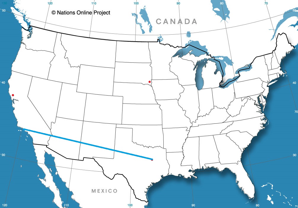
We are traveling cross country this weekend, taking a solid 5 days through the northern US on our trek. It’s a 2,633 mile journey between the two cities in question, which we will do at a pace of 67.5mph. We’ll move quicker in the plains and slower through the mountains (Rockies AND Appalachians). All told, the goal will be 540 miles a day, at least through days 1-4.
DAY ONE (Friday)
What a grimy, miserable pattern that is setting up in the northern US. It’s very busy, and it looks to be that way when we set out on Friday. A cold front will move ashore overnight, and light rain with valley fog will dot the northern Rockies through Idaho and about as far as Frenchtown, Montana, which is west of Missoula. If that wasn’t frustrating enough, the massive complex bringing severe storms to the Upper Midwest will rotate moisture and instability from the northeast — the northeast! — which will press up against the Front Range in Montana, bringing isolated showers and storms to a typically drier stretch of Big Sky Country. Isolated storms are possible, and overcast is likely from Missoula, through Butte and Bozeman and indeed on to Billings, where we will reside for the night. There is a silver lining, I guess, finding a large town to stop in for the night in Montana!
DAY TWO (Saturday)
OK, so there is some good news. The low in the north central US is lifting almost due north, which is allowing some more settled weather to develop in the middle of the country. This will leave a pretty good day of driving as we finish the drive in Montana, cut across Wyoming and finally enter South Dakota. We’ll navigate our way to Kimball, in the middle of the state, and call it a day.
DAY THREE (Sunday)
The good fortune will continue on Sunday, as winds will turn west-northwesterly behind an emerging cold front in the eastern Great Lakes. The big system, now in Canada, will start hustling off to the east, towards Hudson Bay by Sunday morning. A weak little trough will develop in the wake of the front, and could set off some very vague showers and storms in southeastern Minnesota and western Wisconsin by the late afternoon, but I would expect dry conditions in the Madison area as we end our weekend.
DAY FOUR (Monday)
That little post frontal trough is expected to move it about our pace on Saturday. Fortunately, it won’t really get active at any point during the day, but particularly early on as we try to get through Milwaukee and Chicago. Clouds and little bit of light rain will become increasingly likely late in the day as we bound through southern Ohio. We’ll make it to Jackson, which arrives just before the Ohio River and a border with West Virginia.
DAY FIVE (Tuesday)
All this worrying, and it looks like it won’t shake out too badly. Precipitation will be well off shore by the time we traverse Appalachia and settle into the Carolina Plain. Off shore breezes will even work to scour out the threat of morning fog that tends not to stay confined to the AM. Of course, it looks active again in the High Plains as we arrive in Rocky Mount, but maybe that is why we went to North Carolina instead of there?
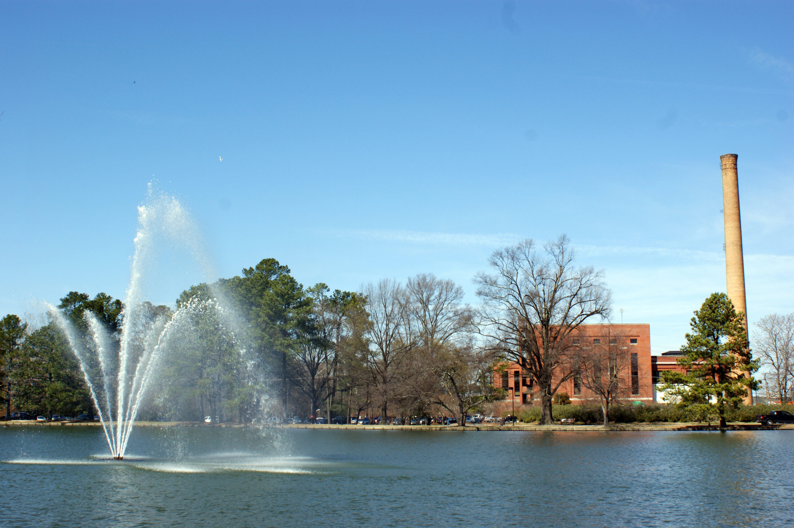
Rocky Mount is on the opposite side of the country from our stops so far this week, and frankly, on the opposite side of North Carolina as where I might have expected.
At 1053AM, ET, Rocky Mount was reporting clear skies and a temperature of 65 degrees. A brisk north wind was helping to keep temperatures from sky rocketing in the clear May conditions. A strengthening ridge over the eastern half of the country promised good conditions for the coast, however a cut off low off the coast was producing off shore rain, and the northerly winds seen in Rocky Mount.
The offshore low is going to sink to the south-southwest, following the coast and weakening as upper level support erodes. As the upper trough breaks down, the surface circulation and moisture will retrograde into the Carolina Plains. Expect increasing clouds overnight with haze and fog for the morning tomorrow. The increasing low layer moisture will ultimately lead to scattered showers in the evening and throughout much of the day on Friday.
Tomorrow – Cloudy with chances for morning fog and light rain in the PM, high 70, Low 56
Friday – Cloudy, scattered showers, High 76, Low 61
TWC: Tomorrow – A few showers early with overcast skies later in the day. high 68, Low 56
Friday – Scattered thunderstorms in the morning becoming more widespread in the afternoon High 76, Low 59
AW: Tomorrow – Mostly cloudy with a shower in the area, mainly later High 66, low 58
Friday – Cloudy, humid and warmer with showers and thunderstorms High 75, low 60
NWS: Tomorrow – A chance of rain, mainly before 10am, then a slight chance of showers after 1pm. High 69, Low 28
Friday – Showers likely, then showers and possibly a thunderstorm after 2pm.High 75, Low 60
WB: Tomorrow – Cloudy. A chance of showers in the afternoon. high 66, Low 58
Friday – Showers likely in the morning, then showers with a chance of thunderstorms in the afternoon, High 75, Low 60
WN: Tomorrow – Cloudy with chance of light rain, High 70, Low 53
Friday – Cloudy with showers and chance of thunderstorms, High 76, low 56
FIO: Tomorrow – Rain until morning, starting again in the evening. High 67, Low 56
Friday – Rain throughout the day. High 75, low 59
Nothing is on shore yet. The north wind cutting out will help with the temperatures on Friday, even if clouds and rain are overhead.
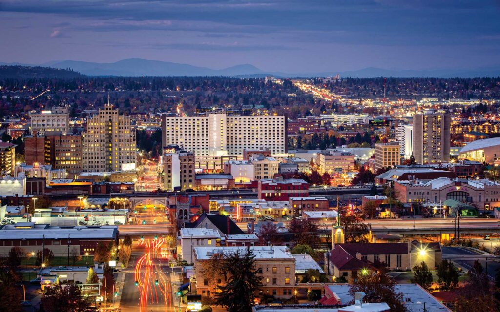
Another stop in our western sojourn as we travel to Spokane. It’s definitely one of our most frequent sites, so hopefully we will have little bit of experience on our side.
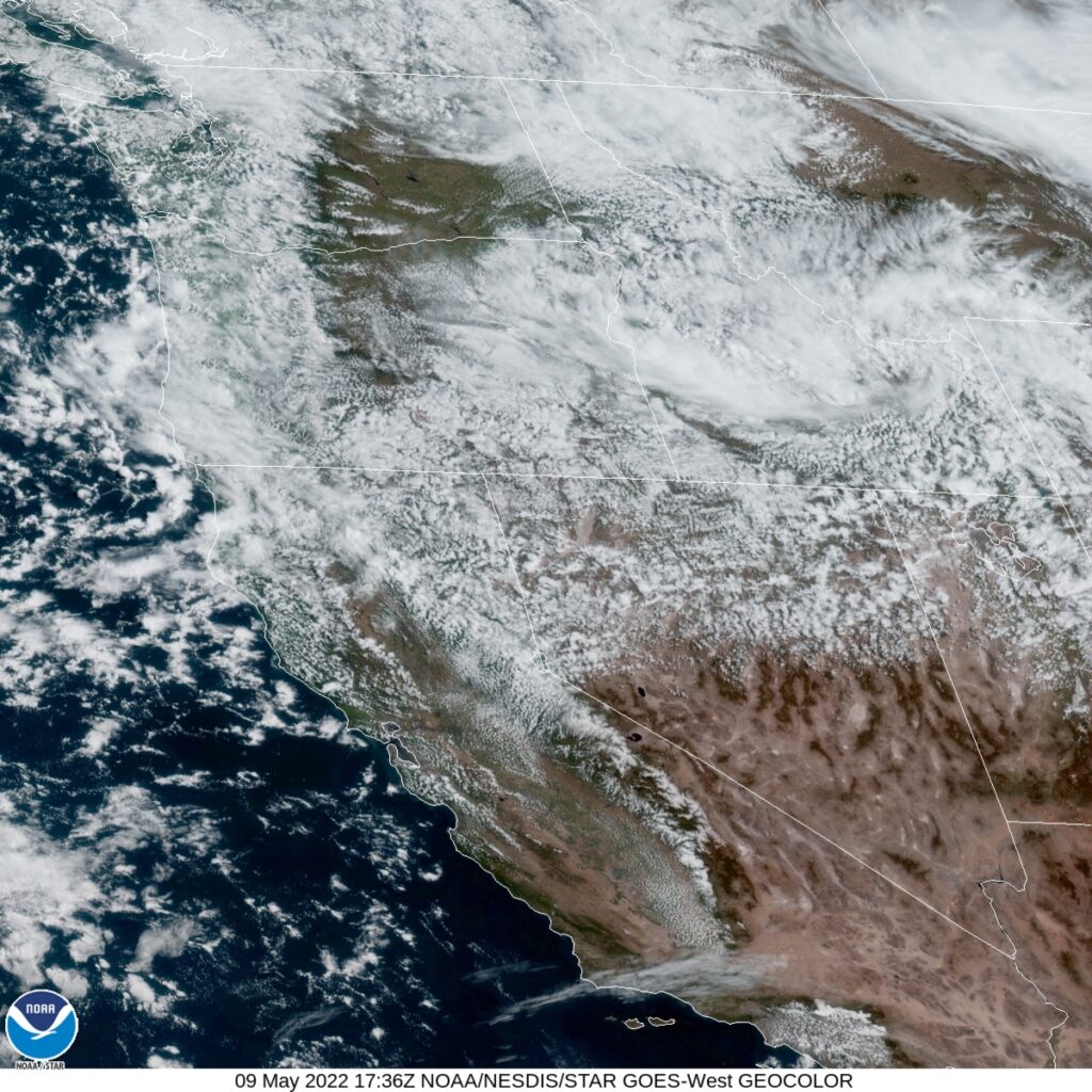
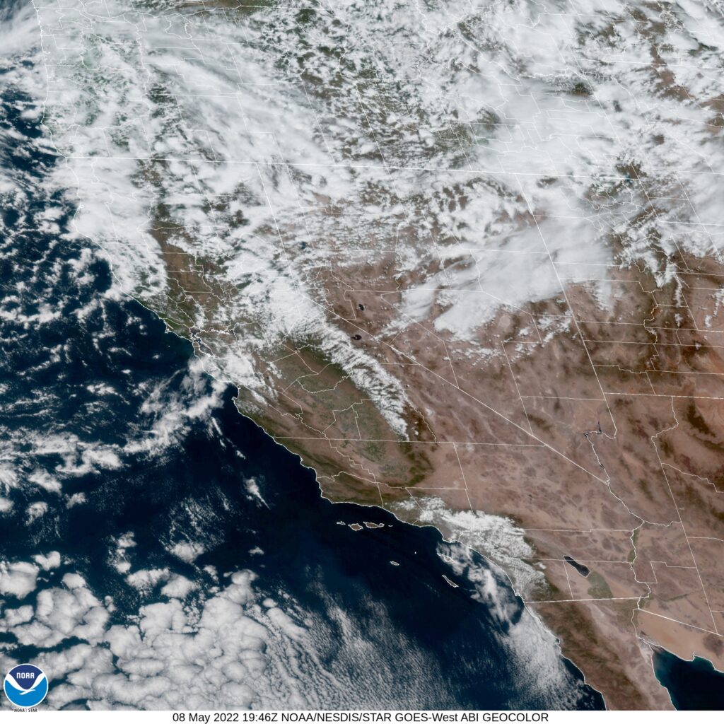
At 953AM, PT, Spokane was reporting a temperature of 42 degrees with overcast skies. Frost and freeze advisories were out for many of the cold-prone valleys in the Spokane region last night, but the overcast will prevent a significant cool down again tonight. Upper level low pressure is continuing to generate rain and even some thunderstorms, of which many will flare again this afternoon and evening. The persistence and future distention of the low is leading to diminishing returns for the storms, thought a few days ago, this system was capable of tornadic development.
the primary surface feature related to this trough has moved off to the Canadian prairies, but baroclinicity remains in place over the Pacific Northwest. At the base of the trough, another area of circulation is developing off the coast of Crescent City, California, and this should blunt the cool weather a bit, but the tandem lows and upper trough will hold cloudy conditions in place. Stronger and more well organized low pressure will emerge with the support of a reanimated lobe of the upper trough over the Gulf of Alaska. While this system advances the circulation off the coast will break down, and for a brief moment, clearer skies will be possible in Spokane, before Thursday sees a return of precipitation.
Tomorrow – Mostly cloudy, High 57, Low 35
Wednesday – Partly cloudy, High 59, Low 34
TWC: Tomorrow – Sunny, along with a few afternoon clouds. High 59, Low 36
Wednesday – Plentiful sunshine. High 61, Low 36
AW: Tomorrow – Cool with variable cloudiness High 58, Low 36
Wednesday – Sunshine mixing with clouds High 60, Low 36
WB: Tomorrow – Partly cloudy. Widespread frost in the morning, High 57, Low 36
Wednesday – Sunny, areas of frost, High 60, Low 36
WN: Tomorrow – SITE IS DOWN
FIO: Tomorrow – Partly cloudy throughout the day. high 60, Low 36
Wednesday – Clear throughout the day. High 63, Low 35
Wow, we haven’t had a website go down in a long time. I’ve looked through multiple browsers and devices but now luck. Chilly in eastern Washington for our forecast, and not a lot of the country can say that this week.
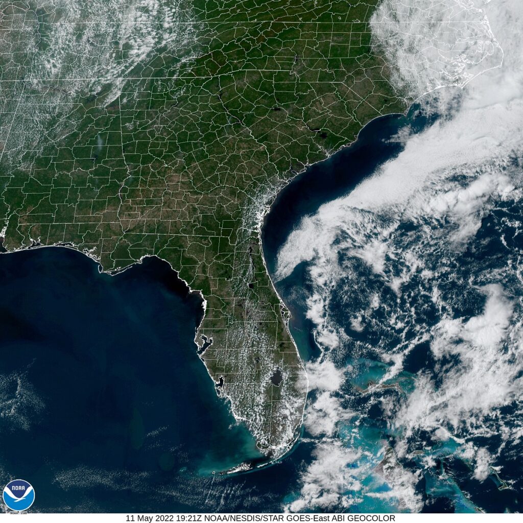
I was in Costa Rica just two months ago. The capital and largest city there is also called San Jose, though I suspect the forecasts to begin this week will be a hair different.
AT 753PM, PT, San Jose was reporting partly cloudy skies with a temperature of 54 degrees. Low pressure in the Pacific Northwest is extending a cold front being reflected at the surface approaching Victorville, while a band of clouds is streamed across the San Jose area. Brisk northwesterly winds give evidence that the boundary is through the region already. Heavy snow is expected in the higher terrain in Northern California as the upper level trough remains entrenched and moisture abundant.
As ridging strengthens in the middle of the country, the upper level trough will contort and dig deeper across the Bay area. Precipitation will become less likely, as a deeply distended trough in the northwest has less access to moisture, but unseasonably cold temperatures will be on the order for Silicon Valley, accompanied by blustery winds.
Tomorrow – Mostly cloudy, High 60, Low 45
Tuesday – Mostly cloudy, High 60, Low 45
TWC: Tomorrow – Mostly cloudy skies early will become partly cloudy later in the day. High 63, Low 46
Tuesday – Sunshine along with some cloudy intervals. High 63, Low 45
AW: Tomorrow – Cool with times of clouds and sun High 62, Low 47
Tuesday – Partly sunny and cool with a shower in places High 63, Low 45
NWS: Tomorrow – A 20 percent chance of showers after 11am. Mostly sunny, High 62, Low 42
Tuesday – A 20 percent chance of showers. High 63, Low 41
WB: Tomorrow – Partly cloudy. A slight chance of showers in the afternoon. High 61, Low 46
Tuesday – Partly cloudy. A slight chance of showers, High, 62, Low 46
WN: Tomorrow – Partly cloudy with light rain showers, High 63, Low 43
Tuesday – Partly cloudy with isolated showers, High 63, Low 41
FIO: Tomorrow – Partly cloudy throughout the day. High 61, Low 47
Tuesday – Clear throughout the day. High 64, Low 45
A wide array for you to choose form. Who will be right in the end? Satellite shows chaos to the north, and one defined boundary in California.
It’s been a long, tough end to the cold season in the Upper Midwest for fans of warmer conditions. May started with more bad news for sunbathers of Omaha. After a storm system dipped south of Nebraska’s largest town, the clear air never forced its way in. Instead, the cold air behind the system settled in, and there was no way to heat it up, thanks to a persistent layer of clouds that lasted through the forecast period. Generally speaking, forecast outlets were more optimistic than what the situation called for. Weatherbug tends to have the chilliest forecasts, and the weather in Omaha played to their advantage on this occasion.
Actuals: Tuesday, .06″ of rain, High 53, Low 41
Wednesday – High 54, Low 48
Grade: C-D
I’m as shocked as you are to see that I am able to put together this award ceremony in a mostly timely manner. It features a return of last year’s overall champion to a spot at the top. I have to commend Weatherbug on their growth through the years. Very often, they were tied to a Weather Channel forecast, and made changes with deleterious results. Now, in 2021, and at least in April 2022, they seem to have figured things out. Congratulations, Weatherbug!
| Outlet | Forecast Wins (year) |
| National Weather Service | 3.5 |
| Accuweather | 2.83 |
| Victoria-Weather | 2.33 |
| Weatherbug | 2 |
| The Weather Channel | 1.83 |
| WeatherNation | 0.5 |
| Forecast.io |

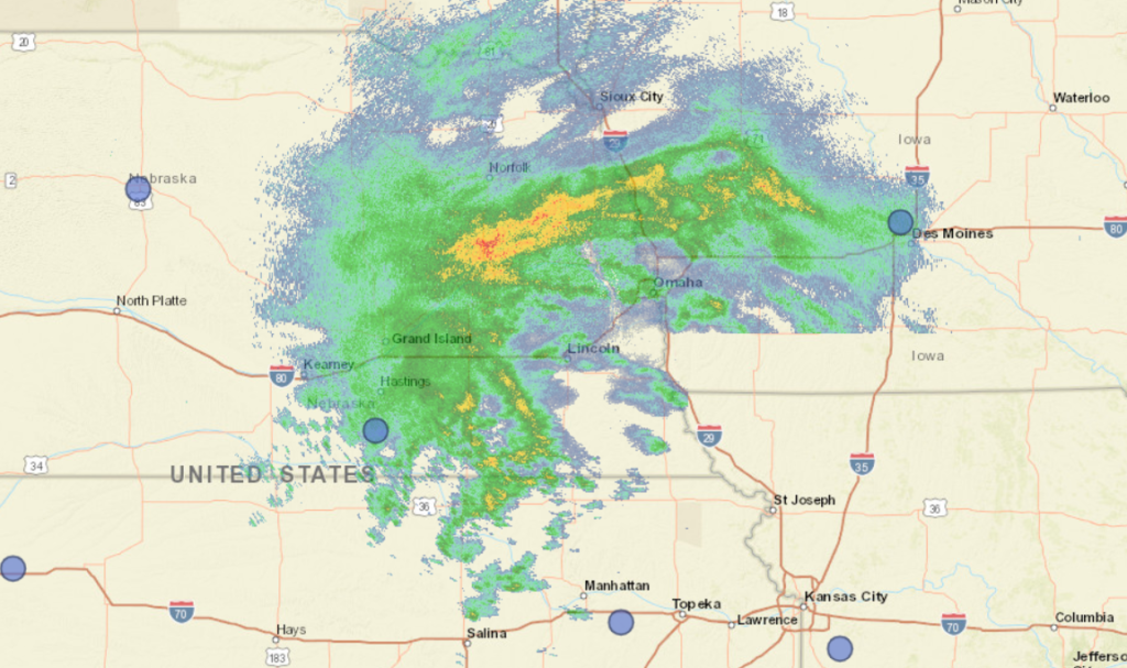
Omaha seems an interesting place to forecast for, given recent outlooks for the region. While today, the severe threat is to the south, if it stays there remains to be seen.
At 252PM, CT, Omaha was reporting cloudy skies with light rain with a temperature of 44 degrees. Brisk easterly winds persisted throughout the region, and worked mostly to hold the heaviest rain at bay, at least for the time being. A band of persistent rain showed on radar from Denison, Iowa to Columbus, Nebraska, and would eventually sink through Omaha tonight, A short wave moving through the central Plains had sunk closer to Kansas City, and the coldest, wettest shot was moving through the Omaha region.
This very same system is causing some wet snow in the western part of Nebraska, but it doesn’t seem like enough cold air will cycle far enough to the east for that to be an issue in Omaha before the precipitation wraps up. The short wave means this system is moving fairly quickly, even if the rain training across the region makes that seem counterintuitive. Things will dry out fairly abruptly overnight, with mostly cloudy skies by tomorrow morning. The next shortwave is already presenting itself in the Pacific Northwest, and will approach Omaha by mid week. Tuesday will largely be unseasonably cool but pleasant, while the next round will increase the clouds on Wednesday. An inverted trough could bring light rain to the region on Wednesday afternoon, with the full brunt of the feature waiting until Friday morning.
Tomorrow – A bit of rain before sunrise, then clearing. High 61, Low 43
Wednesday- Clouds increase with a spot of rain late, High 62, Low 45
TWC: Tomorrow – Cloudy skies early, followed by partial clearing (early rain) High 60, Low 41
Wednesday – Cloudy. Slight chance of a rain shower. High 63, Low 41
AW: Tomorrow – Cool; cloudy in the morning, then clouds and sun in the afternoon (AM Rain) High 59, Low 41
Wednesday – Intervals of clouds and sunshine (PM rain) High 63, low 42
NWS: Tomorrow – Cloudy, then gradually becoming mostly sunny (Early rain), High 60, low 43
Wednesday – A 40 percent chance of showers after 1pm. Mostly cloudy, High 61, Low 44
WB: Tomorrow – Decreasing clouds, late rain, High 56, low 41
Wednesday – Mostly cloudy, a chance of showers in the afternoon. High 59, Low 44
WN: Tomorrow – Partly cloudy with isolated showers, high 60, low 42
Wednesday – Mostly cloudy with scattered showers, High 62, Low 42
FIO: Tomorrow – Rain overnight and in the morning.High 59, Low 41
Wednesday – Rain in the evening and overnight. High 62, Low 41
Happy 40th birthday to the Weather Channel! here is a look at the radar from the Omaha region. Very busy!