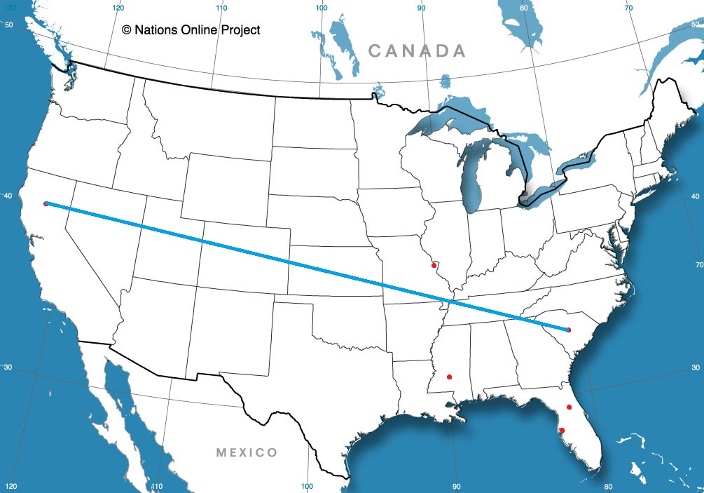
Hinesville, Georgia to Madera, California

We’re ending the summer with a long trip across the country. It will take 4 and a half days, covering 2568 miles. That puts us on a brisk pace of 69.4mph, which won’t seem as great, since we will be on this pace for the better part of a week. The result of each day of driving will be 555 miles traveled. Not bad at all, actually, even if it will still take until Thursday to arrive.

DAY ONE (Sunday)

Hinesville, Georgia

Low pressure in the Great Lakes is demonstrating a nearly perfect comma shape, dangling a cold front from its eastern periphery southwestward towards the southern Plains. The front itself is in pretty rough shape, speaking of precipitation, and isn’t bringing a wintry onslaught, thanks to another system up in northern Canada., but it is going to dangle into our day one route. driving through Georgia and Alabama should mostly be ok, but some isolated showers and storms may pop up at the end of the day’s drive near the Alabama-Mississippi border. They shouldn’t be too obtrusive, but certainly possible. The day ends in Hickory Flat, Mississippi.

DAY TWO (Monday)

The front will be behind us as we leave on Labor Day morning, and while it will probably be cloudy until we hit Arkansas, it shouldn’t be rainy. The sun will be out not long after we reach Arkansas, and we will enjoy the sunshine all the way to Yukon, an Oklahoma City suburb.

DAY THREE (Tuesday)

Even a subsequent area of low pressure churning through the northern Plains and Great Lakes won’t be enough to pull up a return flow into west Texas. The drive from Oklahoma to New Mexico will be dusty and lonely. We’ll make it past Albuquerque, and the day will conclude in Highland Meadows, which is about 20 minutes west of Albuquerque.

DAY FOUR (Wednesday)

The drought continues in the west, and as if to confirm that for us, we will drive through Arizona, which is desertified at the best of times, and end our drive in the Mohave Natural Preserve about an hour into California. About 5 hours left for our Thursday in some blistering heat.

DAY FIVE (Thursday)

Make sure that AC is working. We’ll turn north at Barstow, and it will remain plenty toasty all the way up past Fresno and into Madera. Don’t be surprised if 110’s buckle roads for the last stretch of the drive. Some clouds my finally cool things down on our first full day in Madera, but it sure will be hot when we arrive.

Madera, California

Madera, California

We’re off to the central Valley of California today, to reexamine one of the ongoing hardships wrought upon our planet this summer. Drought continues in California, with fires east of the Madera area. Is there hope on the way?

At 1153AM, PT, Madera was reporting sunny skies and a temperature of 87 degrees. There was a heat advisory in place for the central Valley and the southern California high country along the Nevada border was under an excessive heat watch. High pressure on the west coast was particularly robust and allowing of the abnormal heat.
Low pressure is spiraling independently in the eastern Pacific, and it will give a guide to the shape of the surface ridge through the next couple of days. It will ride well off shore north to the Gulf of Alaska low and begin to merge with that feature. the ridge in the west will change generally unchanged, but the onshore will carry over the Coastal Range and only make it hotter by Monday.
Tomorrow – Partly cloudy, High 101, Low 58
Monday – Mostly sunny, High 103, Low 59

TWC: Tomorrow – Sunshine High 102, Low 58
Monday – Sunshine and clouds mixed High 104, Low 62

AW: Tomorrow – Sunny and hot; danger of dehydration and heat stroke if outside for extended periods of time High 99, Low 59
Monday – Mostly sunny and hot; danger of dehydration and heat stroke if outside for extended periods of time High 103, Low 63

NWS: Tomorrow – Sunny, high 98, Low 61
Monday – Mostly sunny and hot High 101, Low 65

WB: Tomorrow – Sunny, High 99, Low 62
Monday – Mostly sunny, High 103, Low 65

WN: Tomorrow – Mostly sunny, High 99, Low 59
Monday – Mostly sunny, High 102, Low 64

FIO: Tomorrow – Clear throughout the day. High 98, Low 63
Monday – Clear throughout the day. High 101, Low 67

A look at the satellite imagery shows smoke in the clouds across the Sierras, but not much in the way of onshore cloud cover.

Hinesville, Georgia

The coast of Georgia seems to be growing as a tourist destination. Now that we are headed to the autumn, it’s time to start thinking about going some place war.

At 836PM, ET, Hinesville was reporting a temperature of 82 degrees with partly cloudy skies. The remnant Ida remains impactful over the mid – Atlantic, where tornado watches are bracketing the New York City area, but as it reaches the higher latitudes, it is demonstrating traits of a subtropical low, including a ranging cold front that slides south of the Brunswick area. Showers and thunderstorms are seen as near as Valdosta, but is moving away from Hinesville.
The boundary is expected to act as a barrier to onshore flow for the remainder of the work week. Expect a mostly sunny start to September, though the stalled boundary, which will be over north Florida Thursday and Friday, will lead to some waves of clouds in Hinesville.
Tomorrow – Partly cloudy, High 89, Low 72
Friday – Mostly sunny, High 88, Low 68

TWC: Tomorrow – Sunny along with a few clouds. A stray shower or thunderstorm is possible. High 89, Low 72
Friday – Except for a few afternoon clouds, mainly sunny. High 86, Low 68

AW: Tomorrow – Intervals of clouds and sun High 89, Low 74
Friday – Partly sunny; noticeably less humid than recent days High 87, Low 70

NWS: Tomorrow – A 30 percent chance of showers and thunderstorms, mainly after 5pm. Mostly sunny, High 90, Low 71
Friday – Sunny, High 89, Low 69

WB: Tomorrow – Mostly sunny, a slight chance of showers and thunderstorms in the afternoon, High 88, Low 74
Friday – Sunny, High 85, Low 71

WN: tomorrow – Partly cloudy with isolated storms, High 90, Low 71
Friday – Mostly sunny, High 89, Low 68

FIO: Tomorrow – Humid and partly cloudy throughout the day. High 89, Low 73
Friday – Humid and partly cloudy throughout the day. High 87, Low 68

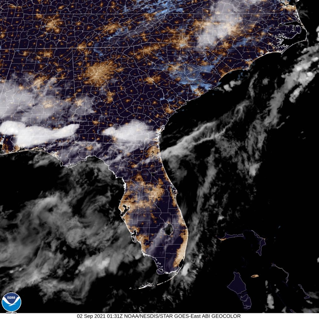
I think the storm activity will stay to the south of Hinesville, but it appears to be a point of contention among the various outlets. Here is a look at the satellite, showing some storms in south Georgia.

Failing to meet expectations

It seems like in so many circumstances lately, the weather has met the extreme ends of forecasts. Intensity, heat, rainfall, it just seems that we are reaching the worst case scenario all too often. When we get a record high potential in the forecast, as we had in Hickory for the past weekend, and it fails to come close, that seems like big news too! Instead of surpassing the mid-90s record highs over the weekend, It didn’t even hit 90 on Sunday, and stopped at 90 on Saturday. Weatherbug is usually helped by forecasts that stay on the cool side, and it was no different in Hickory. WB gets the W.
Actuals: Saturday – High 90, Low 70
Sunday – High 89, Low 70

Grade B-C