Fairbanks, Alaska

It’s always a fun forecast when you have to establish the time zone before you can even begin analyzing the weather.

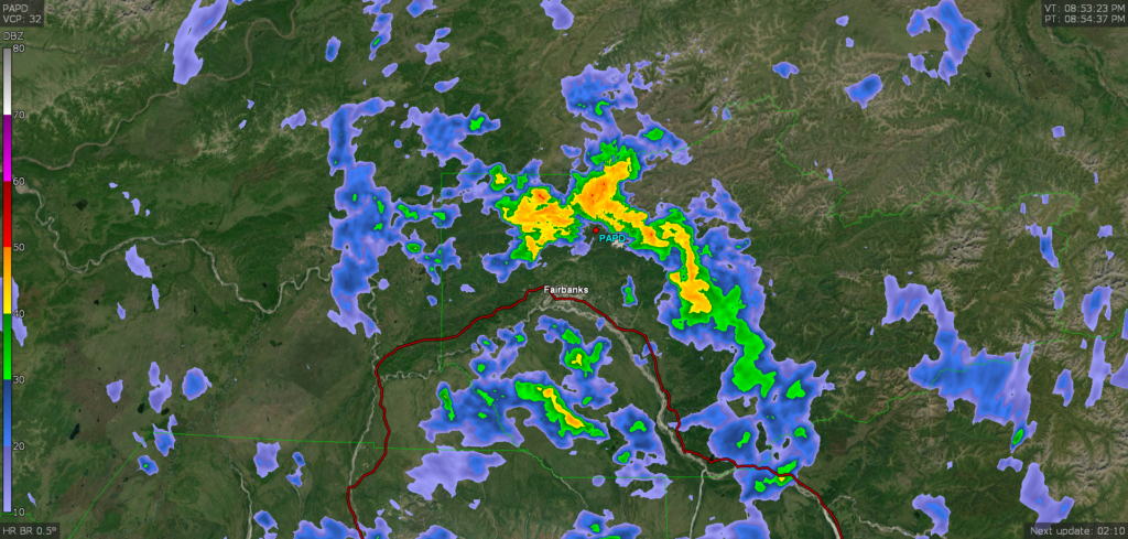
At 553PM, Alaska Time, Fairbanks was reporting a temperature of 53 degrees with mostly cloudy skies. While Fairbanks and the rest of the Tanana Valley were appreciating dry weather, the mountains surrounding were being hit with rain which was heavy particularly to the northeast of the city. Low pressure had settled in north of the Alaska Range, but a lot of the effect was the result of local topography, and the system itself was most well organized over the Yukon and British Columbia.
The feature is prognosticated to shift out of the region by tomorrow morning, allowing the Tanana Valley to dry out. Partly to mostly cloudy skies will remain on Monday. A jet ridge will press north towards southern Alaska by Tuesday, with moist air moving into the Alaska Range, where rain will be possible. For this wave, Fairbanks will be in the clear, with moisture unlikely to descent to the city limits.
Tomorrow – Mostly cloudy, High 60, Low 40
Tuesday – Partly cloudy, High 60, Low 38

TWC: Tomorrow – Partly cloudy in the morning. Increasing clouds with periods of showers later in the day. High 60, Low 41
Tuesday – Mostly cloudy, High 60, Low 39

AW: Tomorrow – Mostly cloudy with occasional rain in the afternoon High 62, Low 43
Tuesday – Turning cloudy (late rain) High 63, Low 39

NWS: Tomorrow – Isolated showers after 10am. Partly sunny High 61, Low 41
Tuesday – Partly sunny High 61, Low 40

WB: Tomorrow – Partly sunny. Isolated thunderstorms in the afternoon, High 55, Low 39
Tuesday – Partly sunny, High 56, Low 39

WN: Tomorrow – Partly cloudy, High 61, Low 41
Tuesday – Partly cloudy, High 62, Low 39

FIO: Tomorrow – Mostly cloudy throughout the day. High 60, Low 40
Tuesday – Mostly cloudy throughout the day. High 58, Low 39

Fairbanks is a tough forecast. It’s not really close to anything else we forecast for, the terrain is absolutely wild, and the models are less available than it is in the CONUS. Here is the radar, with the rain showing up quite well surrounding town.
A promising start

May started off so good in Worcester. By the end of May 3rd, however, rain had moved in and started a cool stretch that would leave the state below normal for an extended period to time. The third was towards the warm end of forecasts, but the 4th, a significantly rainier period, was on the colder side. The Weather Channel navigated to the best forecast, which significantly outpaced a couple outlets, who didn’t have rain forecast for the 4th at all.
Actuals: May 3rd, .03 inches of rain, High 68, Low 51
May 4th, .61 inches of rain, High 56, Loe 46

Grade B – D

Lebanon, Pennsylvania to Kalamazoo, Michigan

It seems like these two towns are far apart, at least in my brain, and I suppose they are. It’s a 603 mile drive, lasting for one long day. We’ll set a pace of 64.2mph, thanked, in no doubt, by the fast drivers of Michigan.

Lebanon, Pennsylvania

Low pressure is still spinning over the St. Lawrence Seaway, and it doesn’t look like it will be motivated to move before we are ready to travel tomorrow. Fortunately, isn’t going to be rich with moisture, and we will be in the car, able to avoid the cooler air the low pressure brings in. Some of the flow coming off the lakes could lead to some clouds and fog on the western faces of the Appalachians of central and western Pennsylvania. Mostly cloudy skies will continue through Ohio and Michigan, but they won’t scrape the surface like they could in Pennsylvania. Kalamazoo will be cloudy and seasonably cool tomorrow evening, but a turn around is around the corner.

Kalamazoo, Michigan

Kalamazoo, Michigan

I hope everyone has had a wonderful Mother’s Day. I know I did, seeing my mom, and watching my wife spend time with our kids is everything I could ask for.

At 1153PM, ET, Kalamazoo was reporting clear skies and a temperature of 44 degrees. The Great Lakes were tucked behind an area of low pressure moving into the Mid-Atlantic. While the north winds were certainly bringing in chillier air, they also provided the clear skies across lower Michigan. The combination of the two is leading to frost and freeze warnings and advisories statewide.
High pressure will build through the next couple of days. The temperature will gradually rise thanks to the spring sunshine, even without a real influx of a new airmass.
Tomorrow – Partly cloudy, High 56, Low 36
Tuesday – Sunny, High 58, Low 32

TWC: Tomorrow – Intervals of clouds and sunshine High 56, Low 35
Tuesday – Sunshine and some clouds High 55, Low 33

AW: Tomorrow – Mostly sunny and cool High 54, Low 31
Tuesday – Mostly sunny and cool High 53, Low 31

NWS: Tomorrow – Patchy frost before 9am. Otherwise, mostly sunny High 54, Low 33
Tuesday – Areas of frost before 9am. Otherwise, sunny High 54, Low 31

WB: Tomorrow – Mostly sunny, Patchy frost until midday, High 53, Low 36
Tuesday – Sunny. Areas of frost until midday. High 53, Low 33

WN: Tomorrow – Partly cloudy with patchy frost, High 54, Low 33
Tuesday – Partly cloudy with areas of frost, High 54, Low 31

FIO: Tomorrow – Partly cloudy throughout the day. High 56, Low 34
Tuesday – Clear throughout the day. High 55, Low 31

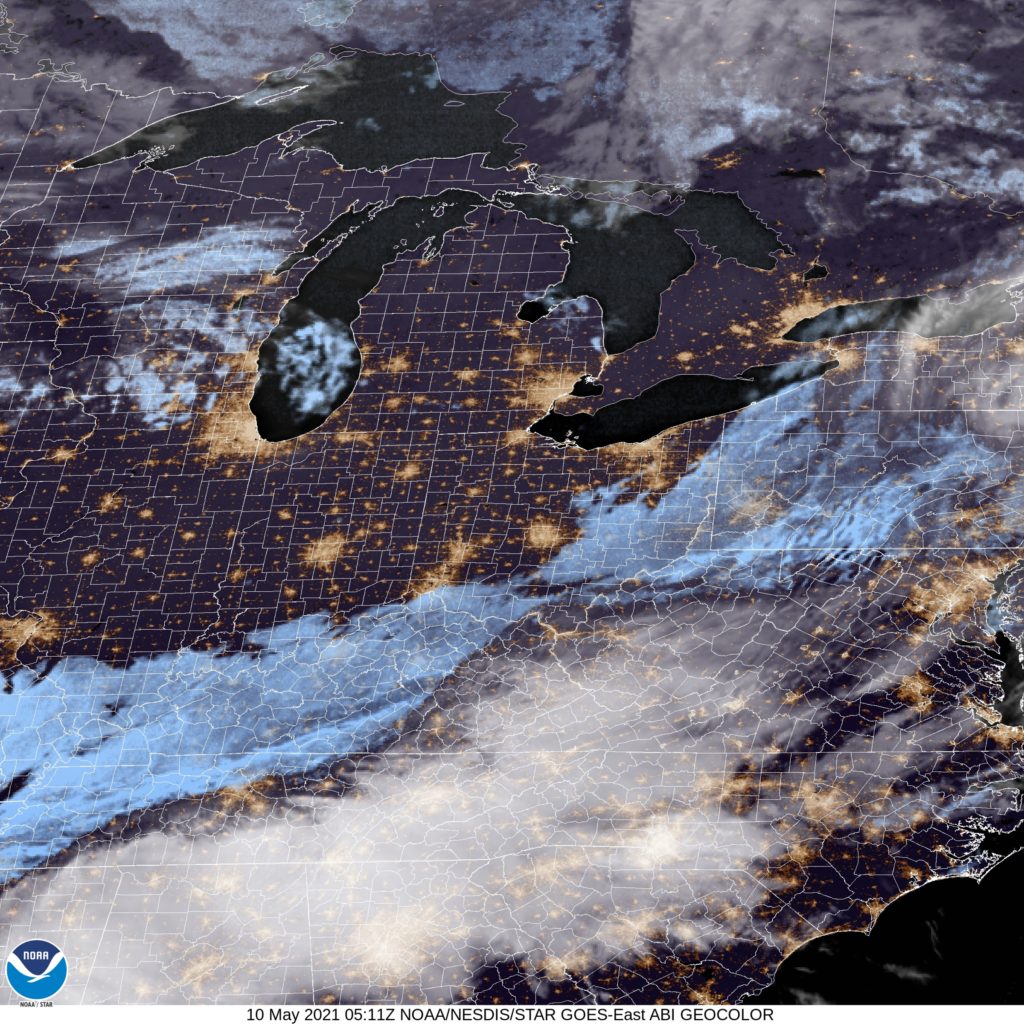
The nasty weather has shifted southeast but a lot of clear skies over the Great Lakes.

Worcester, Massachusetts

I’m not sure there is a town with more unpronounced letters than Worcester, especially by the local population.

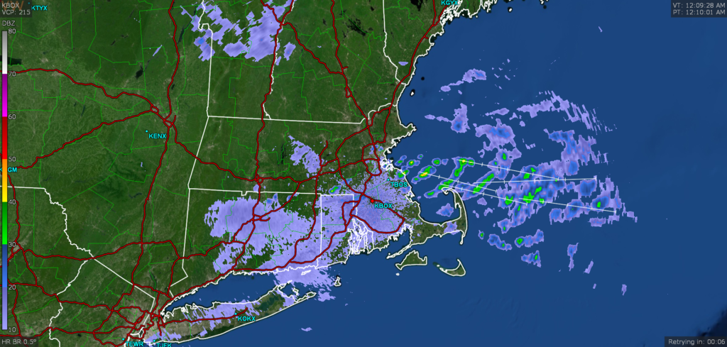
At 1254AM, ET, Worcester was reporting overcast skies with a temperature of 53 degrees. The tail of a weak cold front tailed through the Cape and south of Massachusetts, kicking up an interesting radar return over Boston Harbor, with gravity waves rippling through Massachusetts Bay. It looks quiet over most of New England overnight, though, as the system resposnible for the front is otherwise sequestered over Labrador, and will not cause further problems for Massachusetts.
The next feature is already knocking on the door in the Northeast. Rain will move in from the south, reaching Worcester as early as the early afternoon on Monday. Rain will continue and begin to intensify later in the evening. A warm front might bring an isolated thunderstorm overnight Monday to Tuesday, as the boundary passes The warm sector of the system will linger over southern New England through most of the daylight hours, but more rain will arrive late in the evening as the parent low approaches.
Tomorrow – After noon rain, intensifying late with a rumble of thunder. High 62, Low 50
Tuesday – Early rain, mostly sunny, then rain returns late, High 53, Low 44

TWC: Tomorrow – Cloudy. Late rain High 67, Low 52
Tuesday – Cloudy with occasional rain.. High 54, Low 48

AW: Tomorrow – Mainly cloudy with a passing shower this afternoon High 68, Low 53
Tuesday – A brief shower in the morning; otherwise, low clouds, then perhaps some sun High 58, Low 49

NWS: Tomorrow – Mostly cloudy High 65, Low 52
Tuesday – Showers likely, mainly before 9am. High 63, Low 49

WB: Tomorrow – Mostly cloudy (evening rain), High 63, Low 53
Tuesday – Mostly cloudy with 50 percent chance of showers, High 53, Low 48

WN: Tomorrow – Mostly cloudy, High 65, Low 53
Tuesday – Mostly cloudy with showers likely High 63, Low 49

FIO: Tomorrow – Possible light rain in the evening. High 71, Low 51
Tuesday – Rain overnight and in the morning. High 53, Low 45

I think temperature forecasts have a high bust potential, given the proximity of low pressure to our forecast site. We will find out in a few days. Check out this neat looking radar image from the Boston area, with the radiating bands of rain showers, away from Boston.

Missoula, Montana to Kingston, New York

This May forecast takes us from western Montana to the Hudson Valley of New York. Usually, I try to think of things that places have in common, and frankly, all I’ve got is that the second letter of both towns is the same. They aren’t close on the map, either, requiring a 4 day drive, with the 4th day especially long, to cover the 2416 driving miles between the towns. We’ll move at a pace of 69mph or 552 miles a day, so we will get the most out of the drive too. It’s going to take this long to get from Missoula to Kingston at a fast pace. World’s apart.

DAY ONE (Monday)

Missoula, Montana

Montana is a gigantic state, and we only ever seem to traverse it east to west or west to east. Our drive on Monday, of course, will be west to east, and we still won’t make it out of the Big Sky Country. High pressure is building in the High Plains, with a little bit of moisture on the back end of the ridge butting up against the foothills of the Rockies. We should leave early enough that we will avoid any rain, but the first whispers of clouds will be popping up for the day in and around Missoula, but the rest of our drive in Montana will be under blue skies. We’ll nearly make it to Glendive, Montana, before we turn in for the night.

DAY TWO (Tuesday)
Low pressure is going to get organizing in the Lower Mississippi Valley and moving north to the Great Lakes. This increased organization in low pressure will encourage more stable cold air to move in behind it. Eastern Montana, North Dakota and northern Minnesota will be clear and dry. We will reach Avon, Minnesota, just west of St. Cloud before the day is through.

DAY THREE (Wednesday)
It will be a narrow window between the large system moving into the Great Lakes, and another developing feature behind our route, moving out of the Dakotas into Minnesota and Iowa through the day. We’ll keep just ahead of system, but behind the larger one ahead of us, and voila! A wonderful day. We’ll get through the Twin Cities and Chicago, all the way to La Porte, Indiana. I’ve made a similar drive before, and it is a long one indeed.

DAY FOUR (Thursday)
A slow moving band of light precipitation left over from our trailing weather feature will start to be wrapped into a low pressure center developing in the southeastern US. This will mean less organization and slower progression. There will continue to be a threat of rain just off of our rear horizon, but it will mostly be clear ahead of us. When we hit the Appalachians, the rain will stall, and we should be in clearer and clearer air the further east we head. Downstate New York should be in good shape by the time we arrive.

Kingston, New York

Coming Soon…

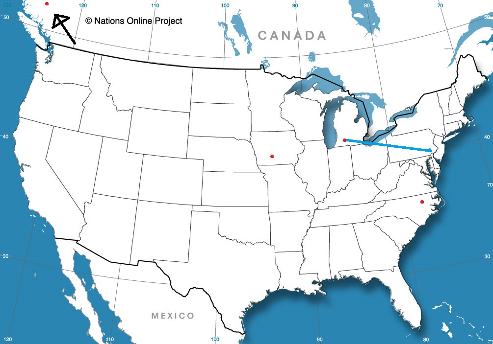
We made it to May, which means we have made it to what I believe to be the most fascinating time of the weather year. What spots around the country will we be visiting?

Kalamazoo, Michigan
Road Trip from Lebanon, Pennsylvania to Kalamazoo

Fairbanks, Alaska

Des Moines, Iowa

Raleigh, North Carolina