The Twin Cities have been very fortunate in that they have avoided severe weather for the bulk of the year. Today, much of eastern Minnesota finds itself (along with Western Wisconsin) in the slight risk area for severe storms. It’s been there for 5 days now. Now, however, the short range models have thunderstorms emerging in northern Minnesota and not popping up south of St. Cloud until after 9, when the boundary is almost out of the Twin Cities.
It’s far too early to make any proclamations, but if the short range models are correct, the Twin Cities will continue their dry, incident free summer tonight.
If you have a moment, Rolling Stone has an article with ways to help residents affected by the devastating Maui wildfires. Our hearts go out to those dealing with so much loss.
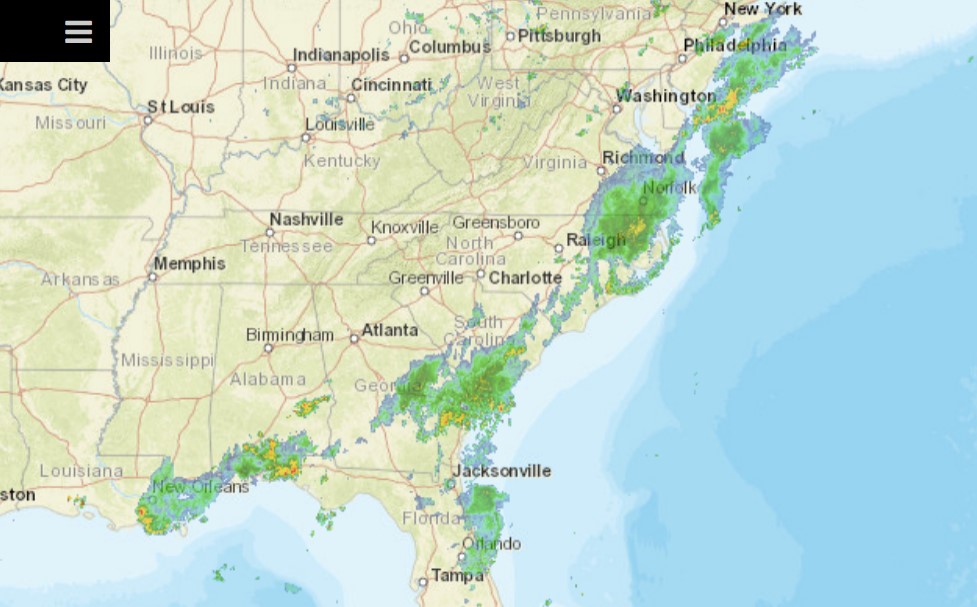
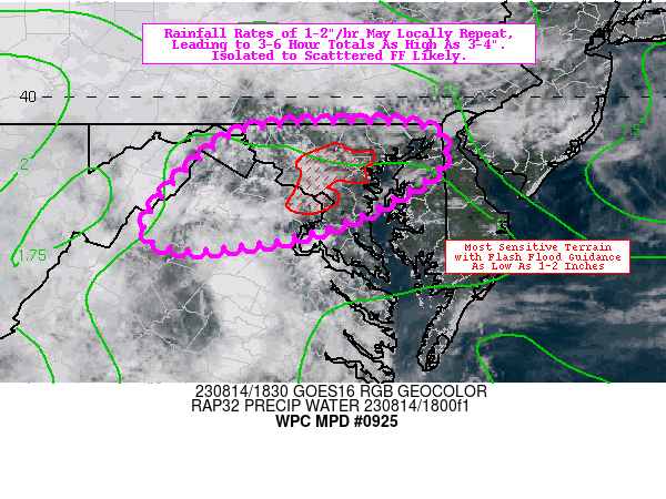
There is a stretch of of the US, generally from the Chesapeake southeast through the central Appalachians, which remains under a slight risk for today. That area will shift only a bit to the southeast tomorrow, and will bring some steady rain along the way. Already, parts of Maryland are being monitored for flash flooding.
The mid-Atlantic has seen a little bit of rough weather of late, and it’s mounting. Heavy downpours are a bit more apt to cause flooding, and that appears to be the situation tonight.
We’re going to head to northern California for our forecast tonight. There hasn’t been as in the news this summer out of California, which is pretty great, but the Yuba City area has been on my mind lately. With the now record breaking wildfires that devastated Lahaina, Hawai’i, I compare the devastation to Paradise, California, which seemed so dreadful at the time. It certainly was, but to think the devastation on Maui is worse boggles the mind.
At 953PM, ET, Yuba City was reporting clear skies with a temperature of 84 degrees. High pressure was in charge, with a few clouds seen over the high Sierras, remnants of afternoon convection. Heat advisories are in place for much of the region. Don’t expect substantial changes with high pressure remaining in place. Hopefully the diurnal convection in the high Sierras feels left out and give Yuba City a bit of shade. Otherwise, there might be an isolated storm in rest of the Valley, but I suspect clouds will be the main impact. Tomorrow – Hot with partly cloudy skies. High 100, Low 73 Tuesday – Fewer clouds, so warmer temperatures, High 106, Low 73
TWC: Tomorrow – Cloudy. High 98, Low 72 Tuesday – Plentiful sunshine. Hot. High 106, Low 70
AW: Tomorrow – Warm with partial sunshine; extreme heat can be dangerous for outdoor activitie High 99, Low 69 Tuesday – Partly sunny and hot; danger of dehydration and heatstroke if outside for extended periods of time High 107, Low 67
NWS: Tomorrow – Mostly sunny and hot, High 99, Low 72 Tuesday – Sunny and hot, High 104, Low 73
WB: Tomorrow – Mostly sunny in the morning then becoming partly cloudy, High 97, Low 71 Tuesday – Sunny, High 105, Low 69
WN: Tomorrow – Partly cloudy, High 99, Low 72 Tuesday – Partly cloudy, High 104, Low 73
CLI: Tomorrow – Mostly cloudy, High 99, Low 70 Tuesday – Sunny, High 105, Low 69
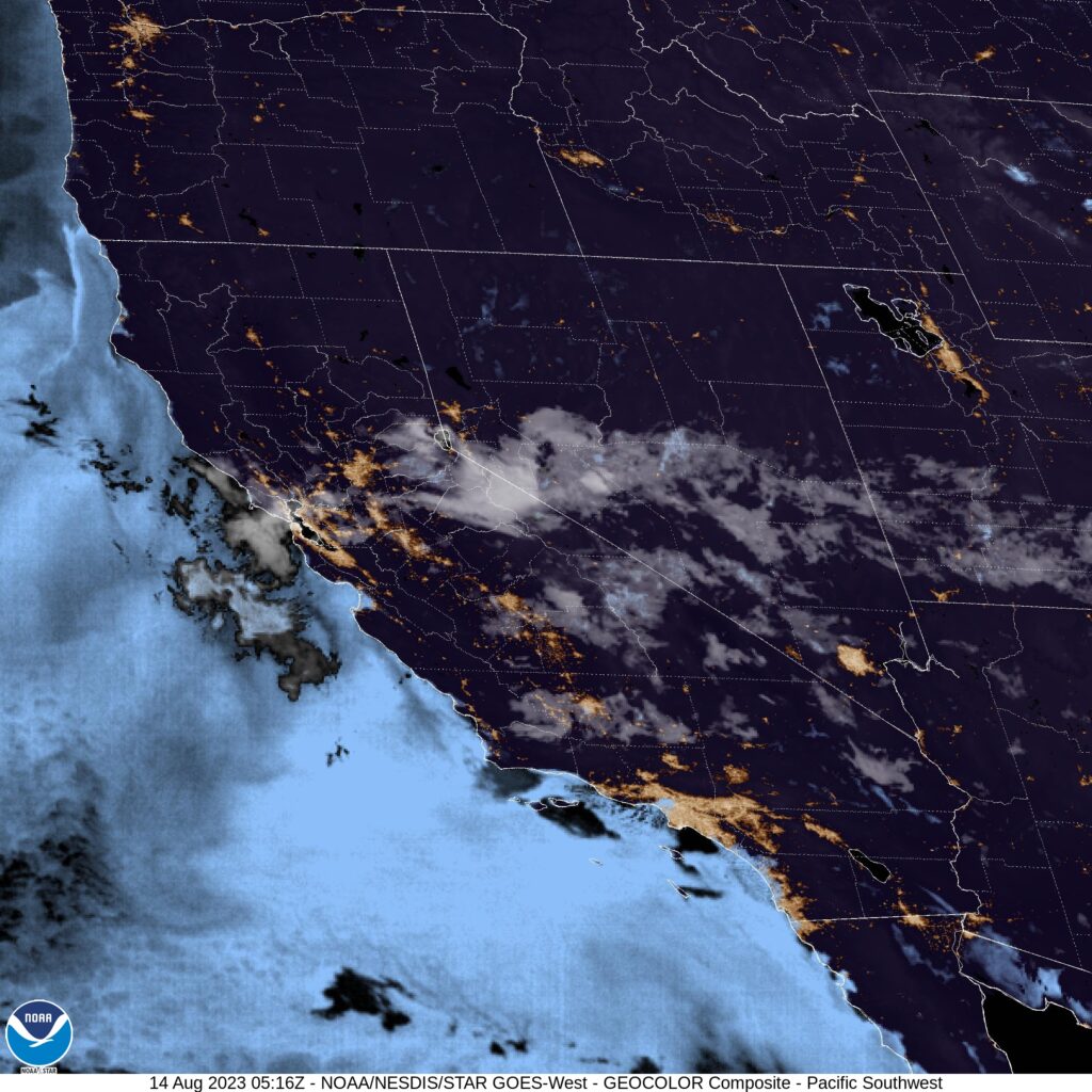
Not a lot on satellite tonight, but it is night that the plumes on satellite are clouds this summer, and not smoke.
One method of forecasting that we have is called “persistence forecasting” which basically using the weather that is seen on one day, and carrying that forward in your forecast. It can work in Florida, especially with what we have see in places like Orlando late in the summer. It’s hot and humid, temperatures generally float at about the same levels, there is usually a stray storm in the area, and you hope to avoid tropical intrigue. That’s how it went for our forecast towards the beginning of the month, though it was a hair cooler than it was when we created the forecast on the 3rd. Accuweather came through with their best performance in a while, and earned victory for the day. Actuals: August 4th, .27 inches of rain in thunderstorms, High 92, Low 76 August 5th, .03 inches of rain in thunderstorms, High 95, Low 79
I’m going to be verifying the forecast for Orlando later today, and while I know that the weather today is similar to what it was when we issued the forecast earlier this week, there is another similarity that is ongoing. It’s the middle of August, but we aren’t looking at any imminent tropical features in the North Atlantic.
With the forecast for hurricanes continuing to be above average, this could certainly change on a dime. The hurricane driven winds that exacerbated the wildfires in Maui, are a reminder that the North Atlantic is not the only place threatened by tropical storms.
Oh, good evening, large thunderstorm cluster bearing down on Philadelphia. Expect some hail out of this guy and some briefly gusty winds. There were some trees down southwest of Reading thanks to this one. Even if this doesn’t bring the severity into Philadelphia, it is still arriving in the wee hours of the morning when you should be sleeping. A rough morning awaits.
We’re marching on through summer, and after failing to mention the top outlets last month, we get a twofer here in August. Weatherbug was the top outlet back in June, a notion belied by their position near the bottom of the Forecast Wins chart. Still, that’s the chart for the year, and one strong set of forecasts can earn you the month, like it did for Weatherbug in June.
With more work done in July, we were able to see an outlet with a stronger win total actually claim the title for the month. In the first month of the second half of the year, the title was claimed by those stalwarts at The Weather Channel. They also scooched on up the Forecast Wins total, but they moved in to 2nd place, which is more impressive than Weatherbug’s second to the bottom.
Congratulations to both of our winners, and to you, for having so many good weather providing options these days.
A large tornado watch continues for the eastern Great Lakes, including a couple of active tornado warnings in northeast Ohio. The watch extends into western New York, but at this time, there are no warnings there. Don’t get complacent yet, there is still an enhanced risk for the region.