
It’s been since the spring, but the SPC has actually started using the Days 4-8 outlook imagery, at least days 4-5, with a mass of potential storms moving through the Ohio Valley to the mid-Atlantic. For now, it is something of a curiosity, but with this much certainty this far out, it seems fairly likely that the outlooks will be upgraded as we get closest to Sunday and Monday.
Social Media Appreciation
The National Weather Service in Omaha is looking ahead to some severe weather in the northern part of the region tomorrow, between 6pm and 1am. I know this because I looked at this graphic for about half a second, and realized that I should share it as an example of meteorologists getting to the point and getting the message across.

Norwegian nonsense
Norway is a very important country in the history of meteorological research. Vilhelm Bjerknes formed the Bergen School of meteorology, which produced meteorologists like his son Jakob and Carl Rossby, as well as the Norwegian Cyclone model, which is one of the first basic understandings of how low pressure systems work, with warm and cold fronts, which reach occlusion and deteriorate. For all that meteorological history and prowess, the country is sure upside down today.

I highlighted a few places, namely the two warm spots and the coolest spot. Tromso and Bodo are both north of the Arctic Circle. Drammen is in the southern part of Norway, southwest of Oslo. (Bergen, the city of meteorological record, is also chilly and in the southern part of the country.) The cities are the same distance apart as New York and Orlando, so this is particularly unusual. When you look at the radar and see most of the North Sea socked in with rain, it starts to make more sense, and when you realize the Arctic is still seeing full daylight for 20 hours a day, it all clicks.
Here we go
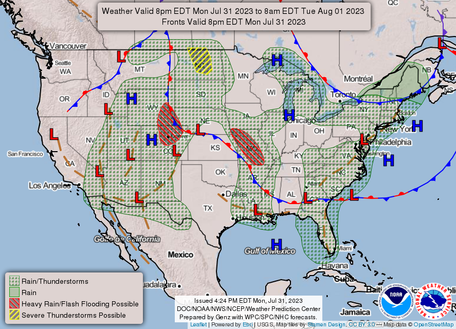
Today is setting up to be an adventurous weather day. As you can see by the graphic on the upper right corner of the page, the SPC has a moderate risk for severe weather in the Appalachians and mid-Atlantic, with a tornado watch already set up for the western face of the range, including much of the upper Ohio Valley. Storms there are just emerging, with the first severe warnings near Parkersburg, West Virginia, and more certainly to follow.
An existing line of thunderstorms is also racing eastward, east of Memphis, and has a history of producing 65mph winds.

If all that wasn’t enough, the SPC also has a mesoscale discussion out for eastern Washington and northern Idaho. I can’t imagine we will remember the weather there like we may remember the weather furth east as the day goes on.
Syracuse, New York
Let’s take a trip northeastward to western New York. Syracuse is a home to a journalism shool, so this is definitely not the first time the town has been written about.
At 854PM, ET, Syracuse was reporting a temperature of 73 degree with cloudy skies. An area of low pressure over the Great Lakes was driving a field of rain north, approaching Syracuse, presently southwest of a line from Batavia to Watkins Glen. The weak jet parenting this area of low pressure is going to steer the low laconically to the northeast. The heaviest shower and thunderstorm activity reaches only as far north as southern Illinois, and is not expected to press further to the north.
Scattered showers will remain in the forecast for each of the next two days as the low pressure meanders through the region. AS the system continues to occlude, the precipitation will become lighter, but move more slowly. Expect things to finally start drying out Tuesday in the late afternoon, but clouds are expected to linger.
Tomorrow – Scattered showers, High 81, Low 67
Tuesday – Light rain in the morning, becoming clearer, High 75, Low 67
TWC: Tomorrow – Scattered thunderstorms in the morning becoming more widespread in the afternoon. High 84, Low 68
Tuesday – Rain showers in the morning will evolve into a more steady rain in the afternoon. High 71, Low 66
AW: Tomorrow – Mostly cloudy and breezy; occasional morning rain and a thunderstorm followed by a thunderstorm in the afternoon High 82, Low 67
Tuesday – Windy with periods of rain and a thunderstorm High 73, Low 65
NWS: Tomorrow – Showers likely, with thunderstorms also possible after 4pm. Mostly cloud High 84. Low 67
Tuesday – Showers likely, then showers and possibly a thunderstorm after 11am. High 77, Low 65
WB: Tomorrow – Showers likely. Thunderstorms likely in the afternoon. Some thunderstorms may produce gusty winds with small hail, frequent lightning and heavy rain fall in the afternoon. High 79, Kiw 66
Tuesday- Showers. High 69, Low 63
WN: Tomorrow – Mostly cloudy with showers, High 84, Low 67
Tuesday – Mostly cloudy with scattered showers, High 77, Low 67
CLI: Tomorrow – Light Rain showers, High 82, Low 66
Tuesday – Drizzle, High 75, Low 68
I[‘m inclined to agree with Clime on this one. I don’t see much in the threat for thunderstorms given the occlusion and position of the area of low pressure. Here is the radar, with rain on the doorstep.

Overnight issues
One area that didn’t experience a recent warm up when it was expected to was Louisville, Kentucky. On July 26th, when temperatures were expected to climb to the mid 90s, the highs just stayed where they had been the day before. Some early thunderstorms certainly prevented low temperatures from dropping significantly on that Wednesday morning, and that factor in particular led this forecast to be fairly middling. The Weather Channel had the only accurate precipitation forecast, with the light storm activity coming on the morning of the 26th, and won the day.
Actuals: July 25th – High 91, Low 70
July 26th – Thunderstorms reported, not measured, High 91, Low 78
Grade: C-D
Hot start won’t last
This is a bit of a long range out look, and it is pretty specific to the northeastern corner of the country. It’s pretty warm in New England, down through the Mid-Atlantic, and with a stalled trough over the Great Lakes, that warmth is going to continue building up into the northeastern US for several more days. According to the long term outlooks for the rest of the month, however, things will be about normal as far south as DC. Fingers crossed that means a pretty cool end of the month?
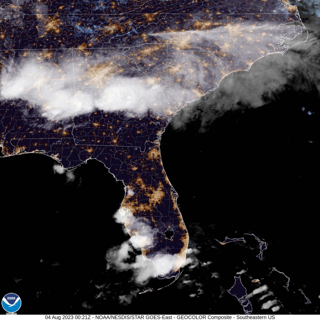
Orlando, Florida
We’re setting forth for Orlando for our forecast today, home, as you all know, to many of the nation’s largest tourist venues. Florida can be unbearable this time of year, but it’s still summer, and people need vacations!
At 753PM, ET, Orlando was reporting a temperature of 85 degrees with clear skies. Thunderstorm activity is starting to peter out as the sun goes down, but is expected to reemerge in the morning. Sea breezes are the primary instigator for thunderstorm activity lately in Florida. The trade winds are stronger than the Gulf breeze, and the storms, as today, have been drifting west towards the Gulf through the day.
The pattern in the southeast is pretty stable. There is a trough in the north east with weak flow through it and a ridge in the Plains. Tropical intrigue has been further north than is typical this early in the season, and the weak trough is enough to have driven activity up into the North Atlantic. Trade activity is expected to remain the only significant pattern in Florida, with isolated thunderstorms tomorrow and Saturday in Orlando. A surface trough meandering into Georgia may invigorate the diurnal thunderstorms
Tomorrow – Isolated thunderstorms, High 94, Low 73
Saturday – Scattered showers with isolated thunderstorms, High 94, Low 74
TWC: Tomorrow – Sunshine and some clouds. A stray shower or thunderstorm is possible High 94, Low 75
Saturday – Scattered showers and thunderstorms. High 90, Low 77
AW: Tomorrow – Sunshine mixing with some clouds with a thunderstorm in the afternoon High 93, Low 75
Saturday – Sun and areas of high clouds in the morning followed by considerable cloudiness with a stray thunderstorm High 95, Low 77
NWS: A 30 percent chance of showers and thunderstorms after 2pm. High 93, Low 74
Saturday – Showers likely and possibly a thunderstorm. Mostly sunny, High 93, Low 77
WB: Tomorrow – Partly sunny. A chance of afternoon showers and thunderstorms, High 91, Low 78
Saturday – Partly sunny with showers likely and chance of thunderstorms, High 90, Low 78
WN: Tomorrow – Partly cloudy with chance of storms, High 93, Low 74
Saturday – Partly cloudy with showers and chance of storms, High 93, Low 77
CLI: Tomorrow – Light rain showers High 92, Low 76
Saturday – Thunderstorm High 91, Low 77
Summer time in Florida. Thunder and lightning just go with the territory. At least the tropics aren’t quite threatening yet.
Mea Culpa
I certainly thought that today, at the very least, would be the last day for showers and storms in the mid-Atlantic. If I am being fully honest, I will admit that I kind of thought yesterday would be that day. Instead, there is just the barest threat for showers and storms even tomorrow.
EDIT:
I guess I will note that the precipitation threat is gone tomorrow between Cumberland and Louisville. I was close, just used the wrong forecast.
Coming Soon…
August is right around the corner – tomorrow, actually – and we are going to dive right into hurricane season. What does the forecast plan look like as all eyes turn to the north Atlantic?
Syracuse, New York
Trenton, New Jersey
Road trip from Yuba City, California to Trenton
Danville, Illinois