I admit that perhaps I don’t have a full comprehension of what Cleveland, Tennessee is like, but it seems as though many of our forecasting counterparts are in the same boat. Temperatures overnight, even in the dog days of summer, sure get comfortable! Low temperatures, closer to – and on Thursday lower than – 60 were well off the forecast mark. Showers and storms never reached the region, further bewildering many outlets. Two of the dry forecasters were at the top of the table, with Victoria-Weather following Forecast.io for the win. Actuals: Thursday, High 91, Low 58 Friday – High 89, Low 60
We’re getting our forecasting chops to start August, so it’s a bit too bad that the pattern is so docile. Maybe I should watch what I say before I start tossing out bad forecasts.
At 153PM, CT, Florence was reporting a temperature of 89 degrees with partly cloudy skies, with an isolated thunderstorm close to Huntsville, with even heavier activity to the southeast. A weak over the Smokey Mountains was helping to enflame shower and thunderstorms across the southeastern US, and will leave the threat of storms in the forecast for Florence this afternoon. There is some upper level structure responsible for this trough, which means there will be some progression. A vast ridge will build in the eastern US, leading to clearing for Florence and a lot of the surrounding area while the trough shifts well off to sea. Expect warming conditions with the bonus sunshine on Sunday. Part of the progressive pattern means low pressure will be able to drop the tail of cold front by Monday afternoon. Expect some locally heavy rains as the storms feast on the hot humid air. Tomorrow – Mostly sunny, High 91, Low 69 Monday – Hot, humid with an afternoon thunderstorm, High 92, Low 70
TWC: Tomorrow – Sunshine and clouds mixed. High 93, Low 70 Monday – Mixed clouds and sun with scattered thunderstorms. High 93, Low 75
AW: Tomorrow – Partly sunny and humid High 93, Low 72 Monday – Partly sunny and humid; a thunderstorm in the afternoon High 93, Low 76
NWS: Tomorrow – Patchy fog before 7am. Otherwise, mostly sunny High 91, Low 69 Monday – A 50 percent chance of showers and thunderstorms. Mostly sunny High 91, Low 73
WB: Tomorrow – Patchy Fog in the morning. Partly cloudy, High 90, Low 71 Monday – Partly cloudy with a chance of showers and thunderstorms, High 91, Low 74
WN: Tomorrow – Partly cloudy, High 91, Low 69 Monday – Partly cloudy with chance of storms, High 91, Low 73
FIO: Tomorrow – Humid and mostly cloudy throughout the day. High 91, Low 67 Monday – Humid and partly cloudy throughout the day. High 91, Low 72
It’s clearing out pretty well for the afternoon in Florence. It looks like the weekend will be good for outdoor activities.
It’s Friday, bit I still have this forecast for Boulder to shoulder.
At 1120AM, MT, Boulder was reporting a temperature of 86 degrees with partly cloudy skies. There were air quality alerts in the mountains and front range, with red flag warnings along the Kansas and Wyoming borders. Meanwhile, there were a couple of showers beginning to bubble up, with heavier activity to the east of Steamboat Springs. The showers and storms today are a product of an upper level trough sweeping through the northern US. The wave is fairly weak at the upper levels, however given the heat and humidity in the plain, there will be plenty of juice for organization. The low developing in the lee of the Rockies will help reengage dry air in the Boulder area, with a northwesterly flow also likely to exasperate the smoke in the air. At least there should be some cooler temperatures tomorrow, but the sun will let things heat up again on Sunday. Tomorrow – Partly cloudy and hazy, High 85, Low 62 Sunday – Mostly sunny but hazy, High 92, Low 62
TWC: Tomorrow – Intervals of clouds and sunshine. High 88, Low 62 Sunday – Except for a few afternoon clouds, mainly sunny. High 94, Low 61
AW: Tomorrow – Nice with plenty of sunshine; wildfire smoke will cause the sky to be hazy High 87, Low 66 Sunday – Partly sunny High 92, Low 62
NWS: Tomorrow – Areas of smoke. Sunny, High 88, Low 61 Sunday – Sunny, High 93, Low 59
WB: Mostly sunny. Areas of smoke. High 84, Low 61 Sunday – Sunny, High 91, Low 61
WN: Tomorrow – Partly cloudy with areas of smoke, High 88, Low 60 Sunday – Sunny, High 93, Low 59
FIO: Tomorrow – Partly cloudy throughout the day. High 89, Low 65 Sunday – Clear throughout the day. High 94, Low 64
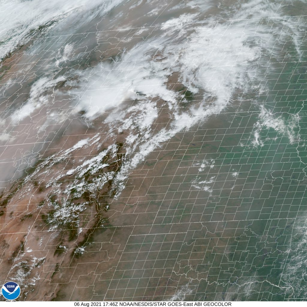
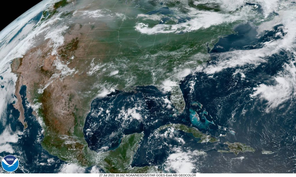
Take a look at the satellite imagery, and just how milky the image is, even in areas without cloud cover. Another smoky summer season.
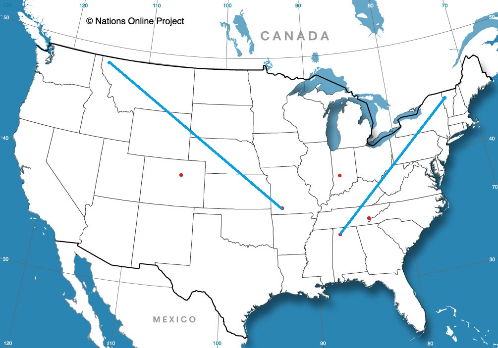
This is sort of an Appalachian Trail route, but it will take only two days to cover the ground, rather than the months it takes to hike. Thanks, interstate highways! The two towns are 1060 miles apart, and our modern travel trappings will allow for a pace of 64.4mph, and no deer ticks.
DAY ONE (Tuesday)
Burlington, Vermont
All of the wet weather in the country is just skirting the East Coast. Sure, there are a few drips and drabs in other places, but there is a bona fide low moving up the Eastern Seaboard with rain and everything. To give an idea with how little of the country this rain is coming to, I will tell you that even on our route, we will see none of it. It will be nice and cool, though, for August. As the low slides into northern New England, we will be in upstate New York, and it may be a bit cloudy through Kingston, but then, south past the New York metro, into New Jersey and through Pennsylvania, we will be in great shape. The route takes through but a sliver of Maryland, but that’s the sliver we will stop in. Williamsport, right on the West Virginia border.
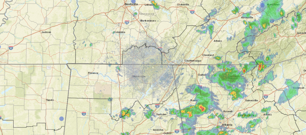
DAY TWO (Friday) A trough moving in through the center of the country threatens to upset the balance of things (wherein the balance was no rain everywhere). Enough moisture will be drawn north out of the Gulf that showers and thunderstorms will dot the skies in Alabama and Georgia by the end of the day on Friday, and there may still be a rogue storm even in eastern Tennessee. It’s not extremely likely, and the threat would be confined to points south of Knoxville. It’s nicer than normal in the south. Enjoy it!
Cleveland is just northeast of Chattanooga, in the well populated stretch of eastern Tennessee that bumps up against North Carolina and Virginia. My goodness, does Tennessee border a lot of states.
At 105ET, thunderstorms were popping up along I-75, just to the west of Cleveland, though in Chattanooga, thunder and a temperature of 71 degrees with overcast skies. Temperatures across the region where clouds were in place were generally in the low 70s, while sunnier parts of north Georgia had risen to the 80s. Low pressured lingering off the Carolina coast was helping to inspire some extra rainfall at the moment, but will eventually work to pull dry air south. A dry day is anticipated tomorrow thanks to the machinations on the East Coast, but a sarp trough moving into the center of the country is expected to draw on moisture from the Gulf of Mexico. There won’t be much organization, and it won’t reach the Cleveland area, but by late in the day, expect an increase in clouds and humidity. Tomorrow – Mostly sunny, High 88, Low 66 Friday – Increasing clouds, High 88, Low 68
TWC: Tomorrow – Sunny along with a few clouds. A stray afternoon thunderstorm is possible. High 86, Low 64 Friday – Overcast. A stray shower or thunderstorm is possible. High 86, Low 65
AW: Tomorrow – Sun and clouds with a passing shower in the afternoon High 86, Low 65 Friday – Mostly cloudy with widely separated thunderstorms High 68, Low 67
NWS: Tomorrow – Sunny, High 85, Low 63 Friday – A 20 percent chance of showers and thunderstorms after 2pm. Partly sunny, High 86, Low 66
WB: Tomorrow – Sunny, High 85, Low 64 Friday – Partly sunny. A slight chance of showers and thunderstorms in the afternoon. High 85, Low 65
WN: Tomorrow – Mostly sunny, High 81, Low 65 Friday – Partly cloudy, High 86, Low 65
FIO: Tomorrow – Clear throughout the day. High 86, Low 61 Friday – Mostly cloudy throughout the day. High 86, Low 65
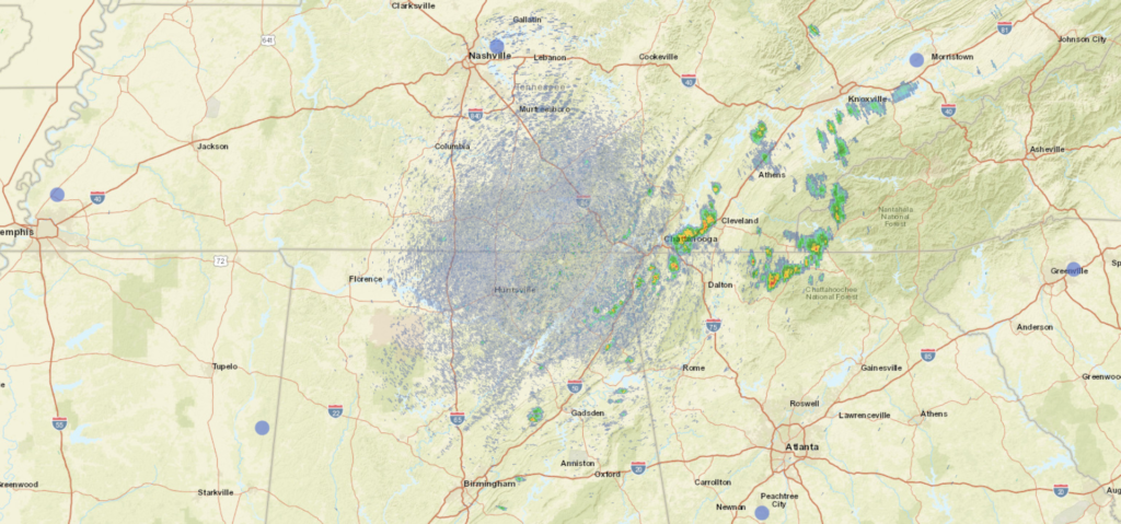
It’s probably going to be a bit warm and sticky, but really for early August this is pretty comfortable. See the radar, with rain in Chattanooga, below.
I wrote the forecast for Fayetteville before I wrote the post about cold fronts failing to take hold in the center of the country. That should tell you something about how this forecast went. Sure, there was a weak boundary sinking through the area earlier this week, but I thought it would bring a bit of northerly flow and some more comfortable air to northwest Arkansas. Instead, temperatures went up by a couple of degrees as the temperatures simply reflected the amount of rain that was seen in the day. A heavy AM thunderstorm on Sunday helped temperatures stay below 90, while they climbed over that mark on Monday, a drier day. The top forecast was split between Accuweather and the Weather Service. Actuals: Sunday – .28″ of rain in thunderstorms, High 89, Low 73 Monday – .03″ of rain, High 92, Low 72
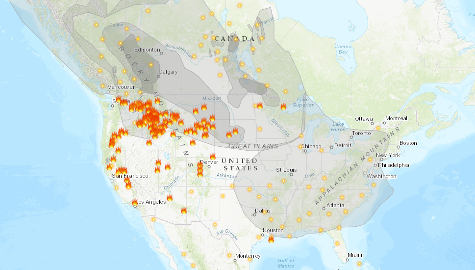
Another summer and we are plagued by wildfires. If there is any difference between this year and the last couple, it is that the bulk of the fire activity is in the northern Rockies, as well as in Alaska, rather than within the state of California. Surely, this is some relief to relatives of the Golden State, and it is definitely a good thing that the fire threat isn’t as imminent to as many people, however it is a burden for the rest of the country.
As this map, from Airnow.gov shows, there is smoke in the air for about 3/4th of the country. Air quality is below normal for all of those locations.
It is rare that the jet intercepts California during the summer, and it isn’t often that smoke can blanket the country as it is right now during a typical fire season. Also frustrating for many of the people getting smoked out right now, is that the flow bringing the smoke in is from the northwest. Were there no fires in the Pacific Northwest and particularly Alaska, the air would be cool and refreshing after a very hot month of July.
Smoke advisories continue to get extended for the region, as relief is not yet right around the corner. Fires, of course, need to be extinguished, but a more immediate source of relief would be a change in the prevailing pattern, but unfortunately, even that doesn’t look to change until at least late in the week.
Last week, Texas was still wrapping up a surprisingly cool start to summer. It was hot everywhere in the country, except in the southeast, and when we looked at Laredo, another round of onshore showers and thunderstorms was just wrapping up for the far southern part of the state. Most outlets had thunderstorms in the forecast for last Thursday, but they never materialized. Nevertheless, it was still cloudy enough that temperatures stayed below 100 one last day. It’s been a scorcher ever since, however. Accuweather had the best forecast for the last gasp of tolerable weather for south Texas. Actuals: Thursday, July 22nd – High 93, Low 75 Friday – High 101, Low 76
In many summers, I find myself rolling my eyes at other outlets’ analyses of the surface. There is often a stationary boundary, left for days along the Gulf Coast of the US. Perhaps a cold front had descended from the Ohio Valley a week prior, but eventually, you need to call a spade a spade. There is onshore flow, and it causes thunderstorms. Not every boundary is a cold front.
This year, and especially right now, we haven’t been seeing those straggler boundaries populating the coast. Right now, it’s evident that there is an off shore boundary pointing into the Carolinas
One might be inclined to analyze something along the band of thunderstorms through north Florida, or perhaps even further north on the clearing line from southern Kentucky to central Oklahoma. In fact, most outlets are keeping truncated fronts, and there is a very good reason for that.
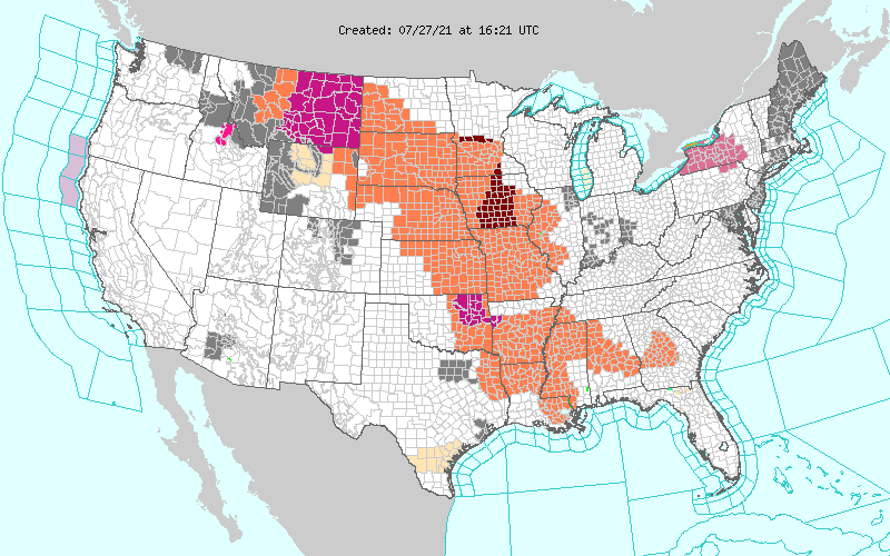
All of those orange and red shades are heat advisories. It is astonishingly hot throughout the Plains and Mississippi Valley. It’s really hard to say there is a cold front when there is a heat wave immediately behind the boundary. The WPC, proponent of the long ranging front, parlays the cold front into a warm front hugging those advisories to the west.
The jet is still somewhat active, but it remains well north of the domestic US. A cooler start to July in the southeast and a blistering start in the north is also starting to level off, but is making for a challenging environment for cold fronts to survive. If a change occurs, it will have to come from the west, which may happen next week.