I have returned from vacation, and if our forecast in New Haven is any estimation, I didn’t really need one. The beginning of March was a warm one in New England, and that usually means rain. That was indeed the case in New Haven, where our forecast swooped in at the end of a warm spell which was ultimately marked by some rain. The cool down was deftly anticipated by Victoria-Weather, and that gained a victory for us. Actuals: March 7th, .02 inches of rain, High 61, Low 48 March 8th, High 49, Low 32
We’ve reached spring break season, and I too am taking a vacation this month. Let’s hope that I am not thinking even a little bit about the weather while I am there! I guess I am saying I don’t want this
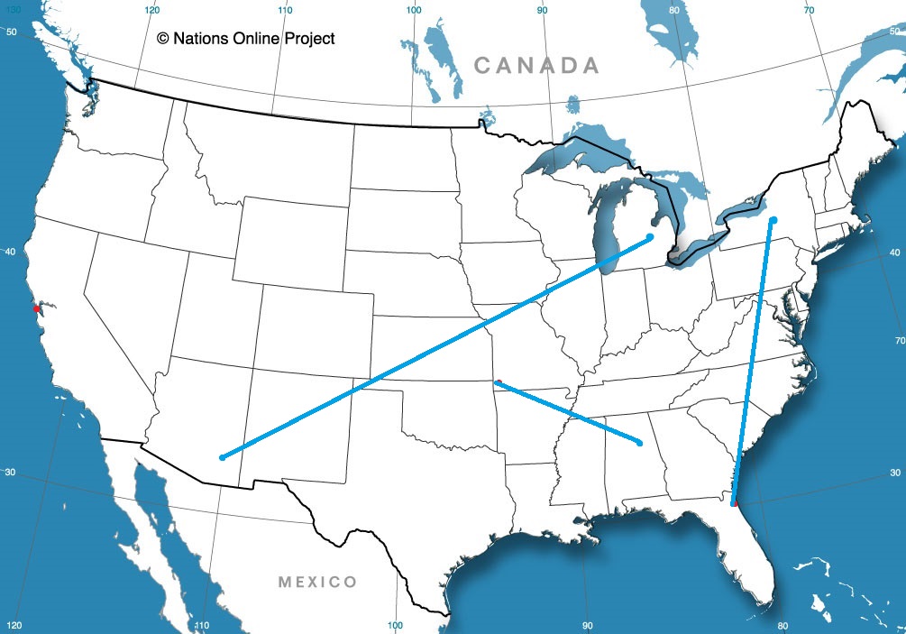
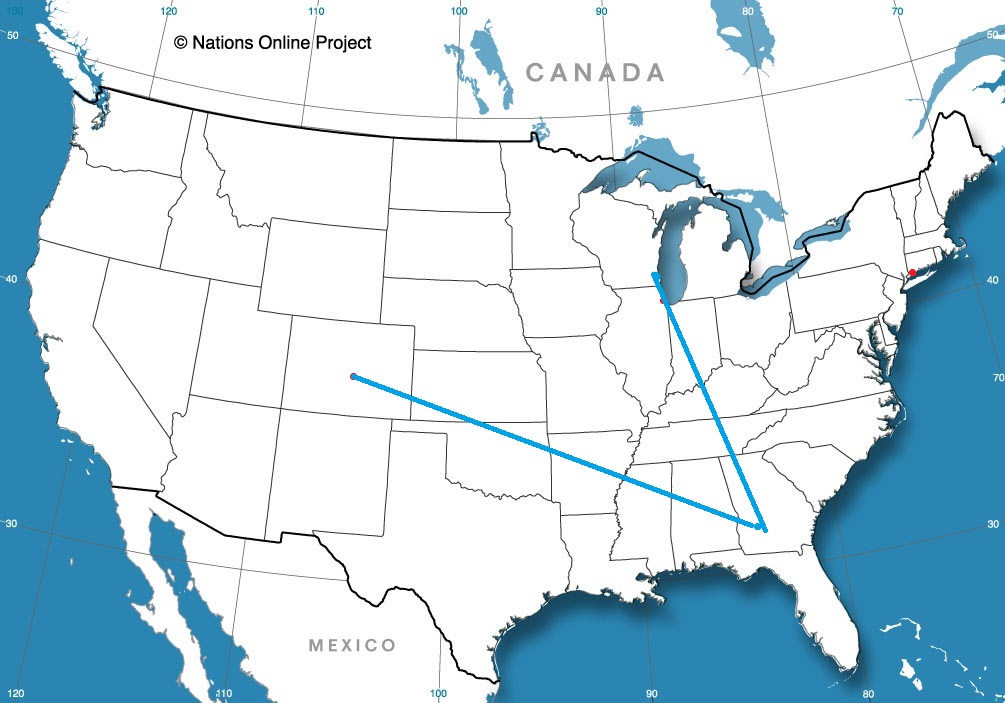
Spring break! Georgia has some great vacation destinations, though I’m not entirely sure that Albany is a site many are thinking of. Our drive for this trek will take three days, with the final day a bit shorter. We’ll cover 543 miles at a day at a pace just shy of 68mph, ultimately traveling 1553 miles on our journey. It’s been active in the southeastern US. Will that continue?
DAY ONE (Sunday)
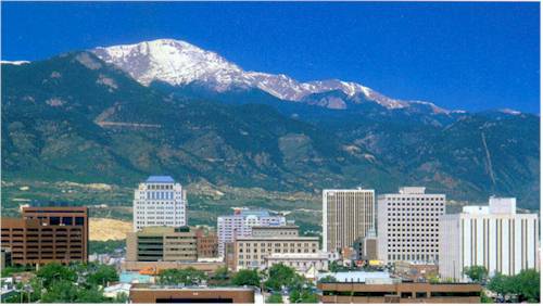
Colorado Springs, Colorado
As I noted, there have been a parade of strong systems moving through the Eastern US of late, and the most recent has just brought snow to the eastern Great Lakes and interior New England, with severe storms along the coastal Carolinas. Behind those features, high pressure has been returning to the Plains and Mississippi Valley. It’s been a chilly start to March, but warm air will start building north on Sunday in western Kansas. It won’t be warm, but it will be warmer as we end the day in Lawrence, Kansas.
DAY TWO (Monday) The next ripple will arrive in the Plains by the beginning of the week, but will initialize with a bit less vitriol than our most recent system. It will get there, but it won’t bother us too much on Monday. Guidance hints at some very scattered showers in Missouri, but they won’t be heavy enough to be a problem in the unfortunate event we pass through one. That threat should abate as soon as we cross into Illinois. Expect mostly cloudy skies with temperatures approaching seasonable in western Kentucky. We will finish the day just across the border in Clarksville, Tennessee.
DAY THREE (Tuesday) A much more focused wave will develop over the lower Mississippi Valley on Tuesday, and will quickly start moving towards our route. Light precipitation will start on the north end of the Atlanta metro. I feel like we should be dry in the high country, so we can save the fun for the chaos of Atlanta traffic. The real show comes around Macon, when thunderstorm activity will become more widespread and intense. Severe weather, including hail and tornadoes, isn’t out of the question. That will probably be the scene in around Albany when we arrive. Get indoors quickly!
In terms of the weather, and especially in the spring, many systems originate in the lee of the Rockies, right here in eastern Colorado. Let’s check out what is getting started over the next couple of days.
At 1054PM, MT, Colorado Springs was reporting a temperature of 27 degrees with clear skies. A vast trough over much of the western 2/3rds of the country is keeping things unseasonably cool. Within the trough, a weak wave has brought light precipitation to the upper Midwest, with a cold front extending to a knot of precipitation centered over Wyoming. At this time, all snow is being penned north of the Palmer Divide, however the entrance of the broad trough is partially responsible for this low, and will give the feature a bit of emphasis in the coming days. Despite the snow currently just over the state line in Wyoming, it will take until late tomorrow afternoon for the snow to reach Colorado Springs. Snow will continue intermittently, as the forcing mechanism will struggle to traverse the divide, and will be oriented west to east across the foothill of the Rockies. The boundary will stall across southern Colorado, but precipitation is going to be light. The lingering clouds and flow off the Divide will help prevent a massive cool down, but Thursday will certainly be chillier. Tomorrow – Increasing clouds with snow late, High 35, Low 16 Thursday – Scattered snow showers, lighter in the afternoon, High 19, Low 5
TWC: Tomorrow – Partly cloudy skies during the morning hours will give way to occasional snow showers in the afternoon. High 30, Low 13 Thursday – Cloudy skies with afternoon snow showers. High 19, Low 6
AW: Tomorrow – Sunny to partly cloudy in the morning, then a coating to an inch of snow in the afternoon High 33, Low 12 Thursday – Colder with periods of snow, accumulating an additional 1-3 inches High 17, Low 8
NWS: Tomorrow – Snow, mainly after 2pm. Patchy blowing snow after 4pm. High 32, Low 8 Thursday – Snow showers likely, mainly after 11am. Mostly cloudy, High 19, Low 3
WB: Tomorrow – Mostly cloudy Periods of snow in the afternoon. Patchy blowing snow in the afternoon, High 32, Low 13 Thursday – Snow showers likely. Light snow accumulations, High 17, Low 9
WN: Tomorrow – Mostly cloudy with light snow, High 31, Low 13 Thursday – Mostly cloudy with light snow showers likely, High 18, Low 3
FIO: Tomorrow – Mostly cloudy throughout the day. High 34, Low 15 Thursday – Overcast throughout the day. High 22, Low 8
Accuweather has a storm total of 4-8 inches of snow in Colorado, while Forecast.io doesn’t have any snow in the forecast. One of them will be wrong. All told, I think 2-4″ of fluff is the most likely scenario in Colorado Springs.
When we put together the forecast for Chicago at the end of February, there was a strong southwest to northeast jet, that really hasn’t changed a whole lot, even now as we enter the middle of March. One change, I suppose, is that the jet has lifted a bit to the north, so Chicago is now warmer, but back in February, the Windy City would get snow on the north side of a feature, followed by cold air. That’s the pattern we followed leading into the last weekend of the month. The cool down rate was a bit challenging, and gave way to some spotty forecast consistency, but ultimately, the Weather Service (who allowed a Midway Airport specific forecast, unlike nearly all other comers) grabbed a victory. Actuals: Friday 2/25 – .04 inches of liquid in light snow, High 31, Low 20 Saturday 2/26 – High 33, Low 16
I love the spring. Winter is such a long slog, and then you start getting this taste of warmth that brings along the first thunderstorm activity of the year. Even when it’s colder, you can bet it’s going to be interesting. Let’s knock out this likely entertaining forecast.
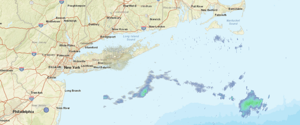
At 453PM, ET, New Haven was reporting sunny skies and haze. An occluded feature over Newfoundland is extending a cold front just to the south of Long Island. This boundary runs further to the east southeast and intersects a more vigorous feature centered over the Ozarks. The resulting languid pace of the boundary south of town will lead to high humidity, and clouds and overnight fog for New Haven in the immediate future. The stronger low to the western low will progress northeastward, buoyed by a rapidly propagating, strong jet perturbation, will moves swiftly to the northeast. The front will back up and move north through New Haven, but without much moisture within the feature. A little bit of rain is possible overnight, but a warm early afternoon will follow. The cold front will arrive in the late evening, perhaps shortly after sunset, and will bring showers and thunderstorms. Precipitation will wrap up quickly, but Tuesday will be breezy and much colder, Tomorrow – Early showers, late showers and thunderstorms with some breezy conditions. High 57, Low 45 Tuesday – Clouds clearing early, with breezy and chilly conditions. High 49, Low 32
TWC: Tomorrow – Cloudy skies with periods of rain later in the day. High 56, Low 48 Tuesday – Mostly sunny skies. High 51, Low 37
AW: Tomorrow – Cloudy and mild; a little rain late in the afternoon High 59, Low 49 Tuesday – Cooler with clouds yielding to sun (early rain) High 52, Low 34
TWC: Tomorrow – Showers likely, mainly after 4pm. Increasing clouds, High 57, Low 46 Tuesday – Sunny High 51, Low 34
WB: Tomorrow – Mostly cloudy in the morning then partly sunny with a slight chance of showers in the afternoon, High 55, Low 48 Tuesday – Sunny, High 50, Low 31
WN: Tomorrow – Mostly cloudy with light showers likely, High 57, Low 46 Tuesday- Mostly sunny, High 46, Low 36
FIO: Tomorrow – Rain overnight and in the evening. high 59, Low 46 Tuesday – Possible light rain overnight. High 53, Low 35
The description of the precipitation is pretty different across the board, from the amount and intensity to the timing. No two forecasts are alike. Not much on the local radar display right now.
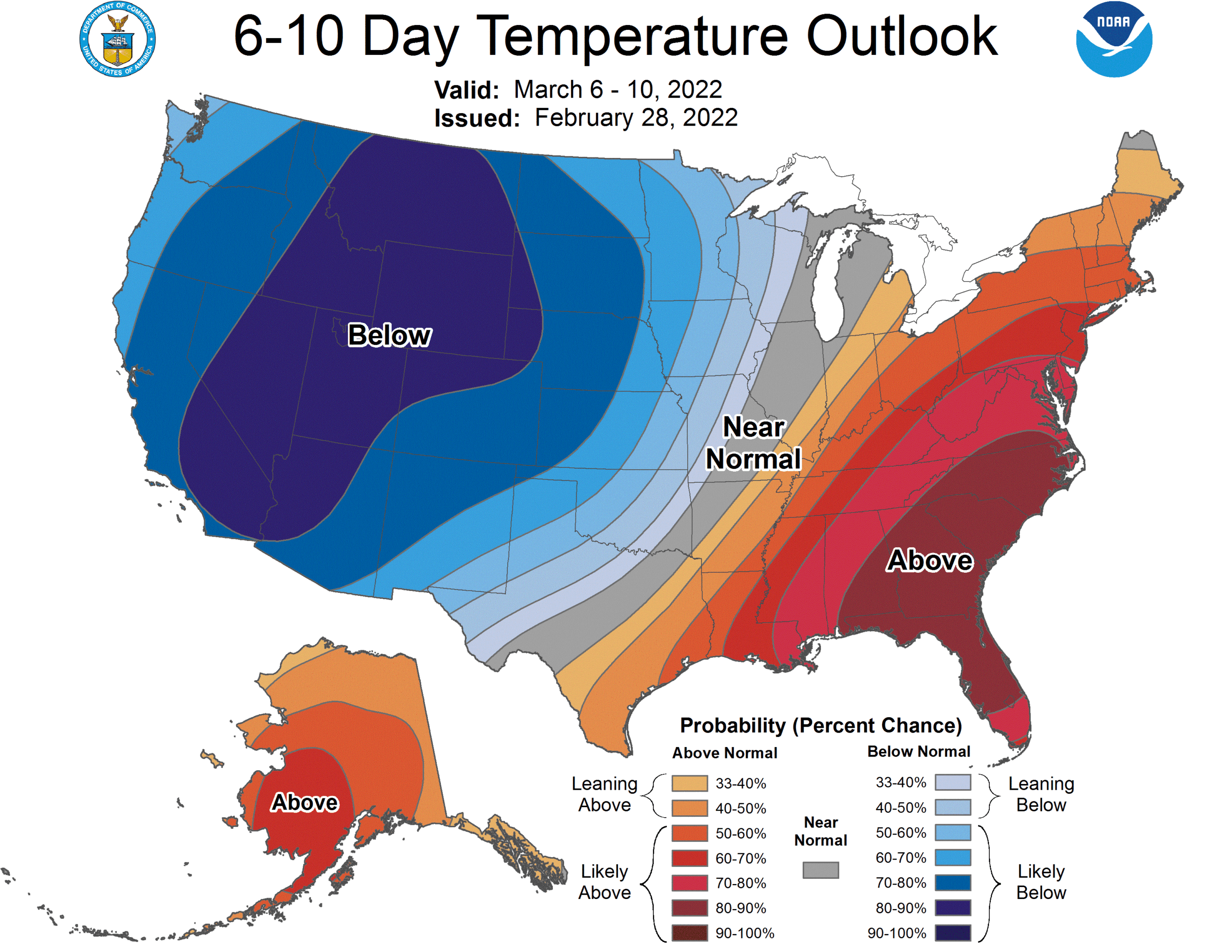
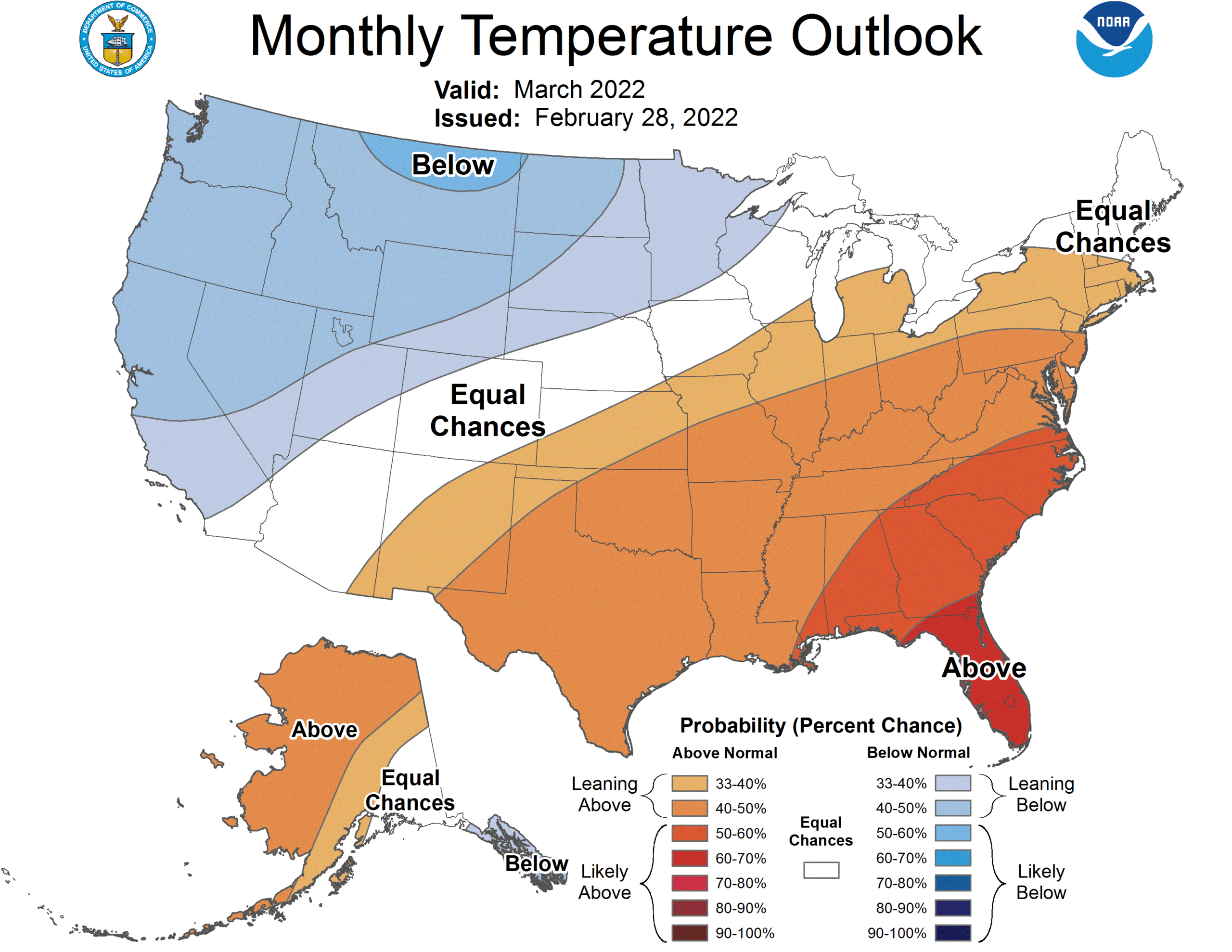
Persistently, for years, the abnormally warm part of the country has been the west. It’s exasperated the drought, fanned wildfires and brought hundreds of millions of dollars of destruction to the region. Finally, the upper level feature preparing to bog down over the western US will be a trough. The long wave, slow moving trough over the western US will ensure below normal temperatures for a large chunk of the Pacific Coast and Rocky Mountains.
The coldest stretch will be in the second week of the month, and there is a good deal of forecast confidence in the below normal temperatures.
The colder weather out west will turn around by the end of the month, as the feature will start to propagate and surely bring severe weather to the Plains, given the temperature change over such a narrow swath of land, showing up even in these long term outlooks. Despite the coming warm up as this broad trough starts moving, the overall outlook for the month of March is for below normal temperatures in the west.
Rain will come to the Pacific Northwest but the trough is going to be far enough east that low pressure will generally develop in the Rockies. Not necessarily a drought buster for California, but perhaps an extension to the ski season will be coming soon.
If you like winter weather, the Great Lakes and New England are great places to be. Snow comes in heavy in that part of the world, and is usually the wet, dense stuff, perfect for snowmen and snowballs, and not the wispy inch or two you get in the Plains that aren’t really good for anything. What is worse than that, though, is when it rains. That’s all they got in Lima on the 11th, in the distant past when we issued our forecast for the northwestern Ohioan town. What a tease! Victoria-Weather saw it coming, though, and collected the top forecast in town, for our first win in 2022. Actuals: February 10th, High 37, Low 28 February 11th – .12″ of rain, High 43, Low 28
The Chicago area covers a lot of territory, and even covers some smaller microclimates, wrapping around Lake Michigan as it does. The site we use to verify defaults to Chicago-Midway, so we will as well. Just know, what happens at Midway doesn’t always happen at O’Hare.
At 829PM, CT, Chicago Midway was reporting a snow with fog and low clouds. A vigorous southwest to northeast trough runs from Texas to the Great Lakes, and a perturbation in the Upper Midwest has led to a surface feature that is presently organizing over western Kentucky, extending an inverted trough through northern Illinois and bringing the snow that is being seen in the region. The low will continue to organize and jet off to the northeast, pressed on by the swift flow aloft. After the surface system and abetting upper level perturbation aloft shift out of the region overnight tonight, expect clearing to take hold. The jet to the south will remain in place, keeping any hope for warmth at bay through the weekend, but the swift flow aloft will lead to some mid to high level clouds, which will keep it a couple of degrees warmer overnight. After flurries end early tomorrow morning, Chicago will be brisk but dry through Saturday. Tomorrow – Early AM Flurries, then a bit brisk, mostly cloudy, High 30, Low 21 Saturday – Partly cloudy, breezy, High 36, Low 20
TWC: Tomorrow – Mostly cloudy skies. A few flurries or snow showers possible. High 29, Low 24 Saturday – Sunny skies High 36, Low 18
AW: Tomorrow – A couple of flurries early in the morning; otherwise, mostly cloudy and cold; watch for icy spots in the morning High 29, Low 23 Saturday – Mostly sunny; breezy in the afternoon High 36, Low 19
NWS: Tomorrow – A chance of snow between 8am and 2pm, then a chance of flurries after 2pm. High 29, Low 23 Saturday – Sunny, High 33, Low 18
WB: Tomorrow – Mostly cloudy and a chance of flurries and a slight chance of light snow in the morning, High 27, Low 22 Saturday – Sunny, High 32, Low 18
WB: Tomorrow – Mostly cloudy with scattered snow showers, High 28, Low 25 Saturday – Sunny, High 34, Low 20
FIO: Tomorrow – Foggy overnight and in the morning. High 29, Low 20 Saturday – Clear throughout the day. High 34, Low 16
A little snowy in Chicago, but we are at the end of it. Only The Weather Service specifically directs to Midway in their forecast offerings, so we will see if that has any bearing on how things turn out.