Gadsden, Alabama

It’s just a northern Alabama kind of day here at Victoria-Weather. Real question is whether we have learned any lessons since last go around.

At 356PM, ET, Gadsden was reporting mostly cloudy skies and a temperature of 82 degrees. A stalled boundary over the Gulf of Mexico was filtering out a lot of the otherwise typical heat and humidity, and high pressure entrenched in the region was backed by a pleasant air mass.
The prevailing flow will remain northwesterly, which should keep Gadsden relatively pleasant through the beginning of the week. A small perturbation will develop in the Bight of Georgia over the weekend, and stir up showers and storms, but this will additionally serve to staunch humidity in eastern Alabama for the weekend. This perturbation looks significantly less than it did in earlier runs, as it will likely be unraveled by what will then be Hurricane Fiona off the coast. This could lead to more clouds than expected in Gadsden, though it should stay dry.
Tomorrow – Mostly sunny, High 85, Low 58
Sunday – Partly cloudy, High 86, Low 60

TWC: Tomorrow – A few clouds from time to time. High 87, Low 61
Sunday – A few clouds from time to time. High 87, Low 63

AW: Tomorrow – Mostly sunny; a beautiful start to the weekend High 86, Low 58
Sunday – Pleasant with plenty of sunshine High 87, Low 61

NWS: Tomorrow – Sunny, High 88, Low 60
Sunday – Sunny, High 88, Low 63

WB: Tomorrow – Sunny, High 85 Low 60
Sunday – Sunny, High 86, Low 62

WN: Tomorrow – Mostly sunny, High 88, Low 58
Sunday – Mostly sunny, High 88, Low 60

FIO: Tomorrow – Partly cloudy throughout the day. High 86. Low 61
Sunday – Partly cloudy throughout the day. high 86, Low 61

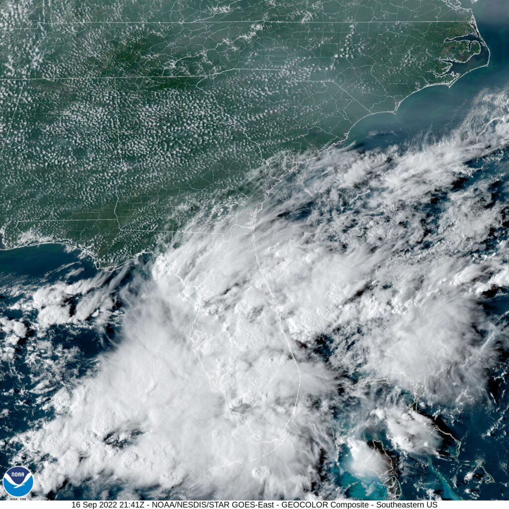
A lot of of popcorn cumulus across the region, but that’s what you get in the south. The real show is further southeast, and even then, it’s not very interesting programming.

A break in the right direction

It seems to this Midwestern forecaster that lately, and especially in the summer, temperatures always sneak past the forecast highs. Apparently, that’s not how it works in northern Alabama! Temperatures failed to surpass 90 in HuntsvHuntsville, Alabamaille as August turned to September, and on the 1st, the low temperature dipped below 60. You can almost sleep in those temperatures! Unbound by our preconceived biases, Forecast.io did not fall into the too warm trap and had the top forecast.
Actuals: August 31st, High 89, Low 64
September 1st, High 89, Low 59

Grade: A – C

Battle Creek, Michigan

One of our most recent forecasts was for Battle Creek, but that doesn’t mean we’ve forecast for Battle Creek recently. Vacation, woo! Back on the horse in Kellogg’s Country.

At 953AM, ET, Battle Creek was reporting a temperature of 59 degrees with overcast skies. Tightly wound low pressure was centered northwest of Manitowoc, Wisconsin, and moisture and clouds blanketed the Great Lakes. Rain showers were for the moment avoiding Battle Creek, though some light activity south of South Bend was on it’s way. Shower activity were retrograding across northern Michigan, indicative of how slowly this disturbance was moving.
The upper trough birthing this surface low is phased with the primary jet stream, found over Hudson Bay. Even though the feature is moving slowly at present, it has motivation to progress to the east, by way of the upper trough. The rain in the area is likely to abate today, with the overcast hanging on through tomorrow, but by Wednesday, clearer, drier air is on it’s way, expected to put a pause on autumn for the time being.
Tomorrow – Mostly cloudy, and a little bit warmer, High 71, Low 49
Wednesday – Clearing and warmer, High 77, Low 56

TWC: Tomorrow – Partly cloudy. Slight chance of a rain shower.High 72, Low 51
Wednesday – Partly cloudy skies. High 78, Low 54

AW: Tomorrow – Intervals of clouds and sunshine with a shower in places High 72, Low 55
Wednesday – Sunny much of the time and nice High 78, Low 55

NWS: Tomorrow – A slight chance of showers before 11am, then a slight chance of showers after 2pm. Partly sunny, High 71, Low 49
Wednesday – Sunny High 78, Low 53

WB: Tomorrow – Mostly cloudy with a 20 percent chance of rain showers, High 70, Low 51
Wednesday – Mostly sunny, High 76, Low 55

WN: Tomorrow – Partly cloudy, High 72, Low 49
Wednesday – Mostly sunny, High 78, Low 49

FIO: Tomorrow – Partly cloudy throughout the day. High 73, Low 48
Wednesday – Partly cloudy throughout the day. High 78, Low 52

Not exactly the most pleasant scenario, but it could be worse. Battle Creek has avoided the copious rains that this system brought to Chicagoland. Here is a deeper dive from Wood TV’s Matt Kirkwood.

Huntsville, Alabama to Wilmington, North Carolina

I am writing up this road trip forecast in the midst of a road trip that has gone awry. I got a flat tire and bent a rim after taking a mountain corner a little too wide, and am stuck until I can get my car fixed. I’m kind of along this route, though, in Spartanburg, South Carolina, so maybe that will help with the forecast. We will be able to cover the ground in one long day, and the route — south of Spartanburg — will be 599 miles long. Maybe it’s just me without a car, but it does seem like the pace here is slow, so 63.5mph, even when using interstates, sounds about right. Keep your eyes on the road!

Huntsville, Alabama

Late this weekend, rain really started to pick up along a stretch from western North Carolina to north Georgia, clearly induced by the ocean sided exposures of the Appalachians. The surface trough helping to enhance the onshore flow and subsequent rain is going to consolidate and shift off the mid-Atlantic coast towards Hurricane Earl. This will bring a slight reprieve in the showers from Huntsville to about Madison, Georgia. The threat for rain has continued to be minimal for much of South Carolina and central Georgia, though with the trough in place, the stretch from Columbia eastward stayed drier anyways. Mostly cloudy skies are likely, and after the threat for spotty showers ends around Madison, we should see dry pavement on to Wilmington.

Wilmington, North Carolina

Huntsville, Alabama

It’s the very end of August, and instead of enduring the heat, many residents of Huntsville – Rocket City, for it’s close ties to the Space Program – are probably indoors following the launch of the Artemis rocket, which was scrubbed yesterday, but will hopefully be launched when weather improves. Speaking of weather, what IS going to happen in Huntsville?

At 1253PM, CT, Huntsville was reporting a temperature of 82 degrees with mostly cloudy skies. Huntsville was one of the rare spots seeing clouds, but high pressure was building throughout the rest of northern Alabama, a rarity this time of year. A line of thunderstorms through central Alabama precedes the south-building ridge, and is allowing Huntsville to enjoy relatively low humidity.
The ridge is going to remain stout in the southeast, and keep Huntsville dry through the middle of the week. The cold front bringing thunderstorms south of Huntsville presently is going to weaken as it hits the Gulf Coast and become more permeable. Expect humidity to start building back into the region throughout the forecast period.
Tomorrow – Mostly sunny, High 92, Low 66
Thursday – Partly cloudy, High 92, Low 63

TWC: Tomorrow – Sunny high 91, Low 68
Thursday – Sunny, along with a few afternoon clouds. High 92, Low 62

AW: Tomorrow – Mostly sunny and less humid High 92, Low 67
Thursday – Plenty of sun High 94, Low 62

NWS: Tomorrow – Sunny, High 89, Low 68
Thursday – Sunny, High 91, Low 64

WB: Tomorrow – Mostly sunny, High 89, Low 69
Thursday – Mostly sunny, High 90, Low 63

WN: Tomorrow – Mostly sunny, High 89, Low 67
Thursday – Mostly sunny, High 91, Low 61

FIO: Tomorrow – Clear throughout the day. High 88, Low 67
Thursday – Clear throughout the day. High 89, Low 60

This is a downright delightful forecast for Huntsville. Dew points in the 60s! Here is a pretty steady line of storms off to the south right now.

Severe storms roll through Twin Cities

Last night, thunderstorms developed along the Minnesota – Iowa border and lifted north through the Twin Cities. One cell in particular tracked from the south metro to the northeast metro. The cell videoed above was part of the tornadic cell, but was not within the tornado warning.

The cells was ultimately responsible for a smattering of weak tornadoes on the southeast side of the Twin Cities metro, with tree damage in some targeted locations on the storm’s path. Eventually, the storm reached the Minnesota State Fair, going on in Falcon Heights, near St. Paul.

Not only did these storms produce quite a bit of strong wind (as seen above), they dumped a quick burst of rain, that left the Fair submerged.

Another line of storms is poised to roll through the Twin Cities in the next hour or so, and though there are some stronger cells, they are mostly non-severe. Just another quick shot of rain — this time focused on the north metro — and a cooler work week ahead.

Historically quiet August appears in order

We are approaching the end of August, and the peak of hurricane season is a little more than two weeks away, and we haven’t had a named feature since Tropical Storm Colin graced the Georgia coast at the beginning of July. The way it looks, we will make it until at least September until we have our “D” storm, given the current NHC outlook.

Each of those two yellow x’s represent a wave that ultimately could become a named tropical feature, but the NHC outlook suspects that formation chance is merely 20% through the next 5 days, which takes us to the end of the month with a day to spare. If these storms fail to materialize, and nothing else crops up in the intervening days, it would be the first time since 1997 that we went through August without a named storm in the Atlantic basin, and only the 2nd time since 1961. The fact that one of those x’s lies off the coast of Africa suggests that there is little time for another feature to arrive behind it, and a surprise is even less likely than usual.

The long range GFS model is pretty consistent with a tropical feature showing up at the beginning of September, and that wouldn’t really be a surprise. There is no causation of a quiet September simply because there is a quiet August. Colorado State hasn’t revised their predictions for the season yet. A quiet season in 1992 didn’t have a named storm until August — Hurricane Andrew. That 1961 season didn’t have any August storms, but did have two Category 5 hurricanes later in the season.

I haven’t found a season that hadn’t had a hurricane by September, though, and that would certainly be unusual, if not historic. We’ve also had the first season in 8 years without a named storm before the hurricane season officially starts on June 1st. It’s been a slow start, and it continues to remain slow for the coming days. We should appreciate that while it lasts.

Battle Creek, Michigan to Omaha, Nebraska

This road trip will be a little bit longer than our intra-Michigan trek yesterday, but it will still take only a day. We’ll cover 619 miles in just over 9 hours, as we skirt Chicago and pass through Des Moines into an underrated town. I think sometimes cities compensate for being in “boring” areas by being extremely interesting. Omaha is certainly interesting, and I would recommend a visit some day.

Battle Creek, Michigan

While today in Michigan is pretty nice (even though I got the road trip backwards! It was supposed to be Jackson to Battle Creek! I digress) there is a weak perturbation moving through the Upper Midwest that will change all that. Excepect some scattered showers and isolated thunderstorms to roll in to the area tomorrow evening, which means we will intercept on the way to Omaha. There will be a chance of these pop up showers – very few and far between – on the south side of Chicago, with the tail of the boundary stationary through southern Iowa. leading to scattered showers mostly south of I-80. Again, even if we see any rainshowers among the corn and Chicago traffic, they will be short lived. Potentially heavy, but short lived. Omaha is great, though, and shouild be drier than points eas.t.

Omaha, Nebraska

Battle Creek, Michigan to Jackson, Michigan

It is not a long drive that we intend to take tomorrow through Lower Michigan. It’s less than an hour and 53 miles from Battle Creek to Jackson. The Google Maps pace is 60mph, but I’ve driven I-94 in Michigan. We’ll be going faster than 60mph.

Battle Creek, Michigan

There really isn’t a lot to say here, honestly. Michigan is a nice enough state, and there are a surprising number of wineries. Not a lot of weather coming through, though. There is high pressure over the Great Lakes, with some mid layered overcast in the northern part of the lakes, but we are on the south side of Michigan, so just enjoy Jackson, I guess!

Jackson, Michigan