This month has been quite rainy for the southern US, but for a strip from the north central to the mid-Atlantic, it has been quite dry for a couple of weeks. It all started with an omega block, which we identified with our forecast in Allentown. Allentown remained dry, despite some storms in the area on the 6th of June, and it was quickly followed by the apocalyptic smoke that descended on the region. A little rain on any number of tracts of land between northern Canada and Allentown would have been great, but it was not to be. Victoria-Weather’s forecast sparkled, and the victory was ours. Actuals: June 5th, High 77, Low 48 June 6th, High 79, Low 52
Fort Myers was the scene of one of the biggest weather disasters of 2022, when Hurricane Ian made landfall nearby. I have family in the area and was there over Christmas, and can speak to the long recovery the area is still struggling to undergo.
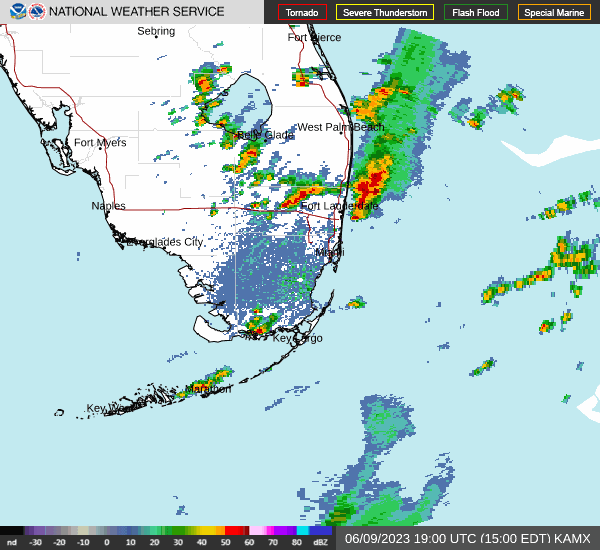
At 353PM, ET, Fort Myers was reporting a temperature of 89 with fair skies. A jet over south Florida was leading to persistent rain showers from the Everglades northeast towards the Atlantic Coast. At this point, heavier, isolated thunderstorm cells had crept up from Lake Okeechobee to Everglades City and eastward to the Atlantic. This band of showers and storms is associated with a cold front that itself is associated with the area of low pressure in New England that is cycling in an overwhelming amount of smoke to the mid-Atlantic. The tail of this jet will shift towards the Bahamas eventually, with the threat for rain not truly out of the forecast in Fort Myers until Saturday. The trough in the mid-Atlantic is going to be even slower to drive out, with flow in the area not shifting to become less northerly until Sunday. as a result, relief from the smoke may have to wait until late in the weekend. Expect streams of clouds to continue to bubble up over far south Florida through the next couple of days, though Fort Myers will avoid any more of the thunderstorm activity, with sea breeze storms becoming prevalent inland. Tomorrow – Partly cloudy and warm, High 91, Low 72 Sunday – Partly cloudy, High 91, Low 74
TWC: Tomorrow – Sunny, along with a few afternoon clouds. A stray shower or thunderstorm is possible. High 90, Low 73 Sunday – Except for a few afternoon clouds, mainly sunny. A stray shower or thunderstorm is possible. High 91, Low 73
AW: Tomorrow – Partly sunny with a thunderstorm in parts of the area in the afternoon High 91, Low 73 Sunday – Except for a few afternoon clouds, mainly sunny. A stray shower or thunderstorm is possible. High 92, Low 74
NWS: Tomorrow -Scattered showers and thunderstorms after 2pm. Sunny, High 89, Low 74 Sunday – Scattered showers and thunderstorms after 2pm. Sunny, High 90, Low 74
WB: Tomorrow – Sunny. Scattered showers with isolated thunderstorms in the afternoon, High 89, Low 75 Sunday – Sunny, Scattered showers with isolated thunderstorms in the afternoon, High 90, Low 75
WN: Tomorrow – Partly cloudy with scattered showers and isolated thunderstorms, High 88, Loe 75 Sunday – Partly cloudy with scattered showers and isolated thunderstorms, High 89, Low 75
CLI: Tomorrow – Light rain showers, High 91, Low 74 Sunday – Light rain showers, High 90, Low 75
I’m leaving rain out of the forecast because it seems like storms are expected to pop up further inland. I know, I know, always have thunderstorms in a Florida forecast. I’m sure I will learn a lesson. Radar is active so far this morning.
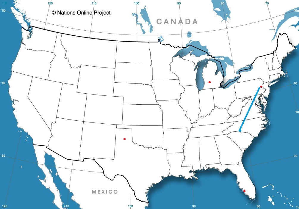
Charlotte and Allentown are definitely Eastern cities, but they have the good fortune of not being along the Coast. This means that our route can take I-81, which is windier, hillier and otherwise more scenic, while also avoiding the traffic of I-95. It will take a day to get from North Carolina to our destination in Pennsylvania, at a pace of 66.4mph.
Charlotte, North Carolina
There are a few clouds streaming across the Coastal Plains as low pressure churns off the coast of New England. The low will drift to Nova Scotia, while breezier and relatively cool air continues to press south. The flow will be coming up an over the Appalachians, so relative to the conditions throughout the rest of Vieginia, expect clearer skies. As we pass west of Baltimore, we will get north of the front, which will shear away the remaining threat of wet weather. Allentown will be delightful and awaits our arrival.
I know some people that live in Allentown, and they commute to New York City at times if they need to go in the office. Can you imagine, potentially going through three states in a day just to get to work? We’re only going to be looking at Allentown though, and limit our scope to just the one state.
AT 1051PM, ET, Allentown was reporting clear skies and a temperature of 54 degrees. Clear skies are seen across the region. Allentown is at te eastern flank of an Omega Block across the middle of the country. Low pressure developing on the eastern flank of the features is rising north along the Coast, while a weak cool front off the tail of the system has recently passed Allentown, making life a bit more tolerable after a hot weekend. As is often the case with blocking patterns, don’t expect much change over the next couple of days. Low pressure will retrograde into Nova Scotia, and the boundary will stall. At varying instances, there may be some additional clouds, and some stronger north breeze. A light shower may crop up on Tuesday. Tomorrow – Partly cloudy, High 76, Low 48 Tuesday – Partly cloudy with a chance for light rain, High 80, Low 52
TWC: Tomorrow – Sunshine and clouds mixed. High 78, Low 47 Tuesday – Mostly sunny skies. High 78, Low 53
AW: Tomorrow – Intervals of clouds and sunshine High 77, Low 50 Tuesday – Partly sunny with a brief shower; smoke from distant wildfires can cause hazy skies and poor air quality High 77, Low 55
NWS: Tomorrow – Increasing clouds High 78, Low 48 Tuesday – A slight chance of showers, then a chance of showers and thunderstorms after 2pm. Sunny, High 78, Low 55
WB: Tomorrow – Sunny in the morning, then becoming partly sunny, High 77, Low 48 Tuesday – Mostly sunny. A chance of showers in the afternoon. High 77, Low 53
WN: Tomorrow – Partly cloudy, High 78, Low 49 Tuesday – Partly cloudy with isolated showers and storms, High 79, Low 54
CLI: Tomorrow – Mostly cloudy, High 75, Low 46 Tuesday – Light rain showers, High 75, Low 52
It’s pretty warm in the middle of the country, and it was this weekend in Allentown. What a terrific break this weather will be.
Residents of Prescott likely live in town for one big reason. Days like those they saw at the beginning of Memorial Day weekend. Temperatures were in the mid 70s for highs with bright sunshine and cool lows overnight. Not the scorching heat to the south, no humidity and just some fantastic days to spend outdoors, really participating in any activity one might want to do. The Weather Channel and Clime were able to tie atop the leaderboard. Perhaps the forecasters can be rewarded with a trip to Prescott. Actuals: Friday, High 75, Low 51 Saturday, High 75, Low 45
Memorial Day is the unofficial kick off to summer for a lot of people. There is only about a week left of school, give or take, for most people, June is around the corner and even the most northerly spots in the United States would be rightfully upset if they saw snow. Still, late may and early June in the Upper Midwest is usually in the mid 70s for a high. Warm, for sure, but not sweltering.
This version of the earliest stretch of “summer” features a blocking pattern in the center of the country. A temporary pulse down in the overall flow into the ridge is allowing a bit of progression for the pattern. This means that on the western side of the ridge, there is room for the trough to lead to surface development.
And if you are a long time reader of the site, my book, or just a first timer generally knowledgeable of things meteorological, you will know southerly flow precedes low pressure, and that means a hot, humid warm up for the middle of the country. In fact, for the next week, most of the north central US will be double digits warmer than normal.
The temperature outlook through the first weekend of June includes above average daily highs across much of the Northern Tier. Early summer warmth with high temperatures into the upper-80s and low 90s can be expected in these regions, shifting to include the Northwest by Friday. pic.twitter.com/MNNx0bWy0C
— NWS Weather Prediction Center (@NWSWPC) May 29, 2023
Low pressure at either coast, including the one driving warm air north, are keeping temperatures below normal in California and the mid-Atlantic, while the fact that it is just generally hot already this time of year along the Gulf Coast are dampening some of the numbers there.
The hot, soupy weather will lead to some afternoon convection for much of this warm region, while surface features bumped up into Canada will ensure a little bit of extra convection later in the week in the Northern Plains and western Great Lakes. The calendar will say June, but it will fell like July or August for a few days.
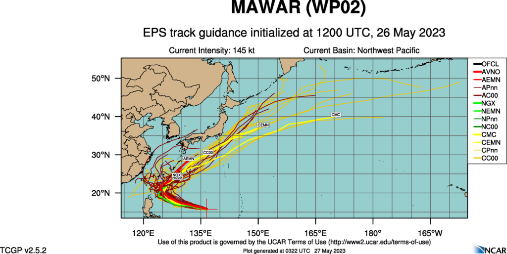
Earlier this week, Supertyphoon Mawar swiftly intensified, then crashed through Guam as a Category 4 storm, the strongest in memory for the US dependency. Damage is extensive, power is out to the island and the recovery will be long and hard. Two men lost their lives, which is tragic, but also a lower figure than one might have anticipated. Mawar only strengthened after passing over the Mariana Islands, but if forecasts are accurate, Mawar will not go down as one of the typhoons of legend in the western Pacific.
There is some model consensus on Mawar’s future. An area of low pressure is expected to move out of eastern Mongolia and northeastern China, across the Korean Peninsula and into the north Pacific. It will drag a cold or stationary front westward and south through China. This will have an effect of bringing Mawar to a full stop, northwest of Luzon in the Phillippines and east of Taiwan, two major population centers.
Mawar will still get close enough to both islands to bring high surf and the portential for a little storm surge, especially given the proximity suggested by some models to Taiwan, but we aren’t expecting a direct landfall of this strong storm on either. Then, as Mawar weakens, it will turn north towards, but ultimately southeast of the home islands of Japan, another crisis averted.
That certainly isn’t to say that Mawar will be totally unimpactful after Guam. The storm will move swiflty through the Bonin and Volcano Islands, the most famous of which for Americans is Iwo Jima, which is presently uninhabited. There are also important shipping channels that will be disrupted while the storm churns between all these commercial venues.
There is plenty of time for the tropical season to take a more sinister turn, but for now, we tentatively have had a stay.
Arizona has a reputation as being a hot, nearly desolate place in the summer, outside of Phoenix, which is simply hot. Many population centers in Arizona though, have sought refuge in the cooler mountains in the rest of the state. Prescott is one of those towns!
At 1253PM, PT, Prescott was reporting clear skies and a temperature of 75 degrees. As if to illustrate the point of a chillier time in the mountains, the Sun Valley and Phoenix remained in the upper 90s. Temperatures were decided by elevation, and moisture was relatively low. The dry line straddling the Texas-New Mexico border was active, and keeping Prescott and the southwest out of the monsoon, which was already ongoing in the central Rockies. Aiding the dry line was a weak area of low pressure that had found its way to an anchorage in the southwestern corner of the US. A blocking pattern in the center of the US was going to keep this regime in place for the next several days at least, with moisture kicked up and around the Grand Canyon State. The low pressure will help ensure temperatures in Prescott don’t match those found at lower elevations and to the south for the duration of the forecast period. Tomorrow – Mostly sunny, High 72, Low 49 Saturday – Mostly sunny, high 76, Low 49
TWC: Tomorrow – Mainly sunny, High 73, Low 48 Saturday – Sunny, High 75, low 46
AW: Tomorrow – Plenty of sun; breezy in the afternoon High 77, Low 48 Saturday – Pleasant with plenty of sunshine High 77, Low 44
NWS: Tomorrow – Sunny, High 77, Low 47 Tomorrow – Sunny, High 79, Low 47
WB: Tomorrow – Breezy, Sunny, high 72, Low 42 Saturday – Sunny, high 74, Low 41
WN: Tomorrow – Sunny, High 72, Low 44 Saturday – Mostly sunny, High 78, Low 47
CLI: Tomorrow – Sunny, High 73, Low 48 Saturday – Sunny, high 75, Low 46
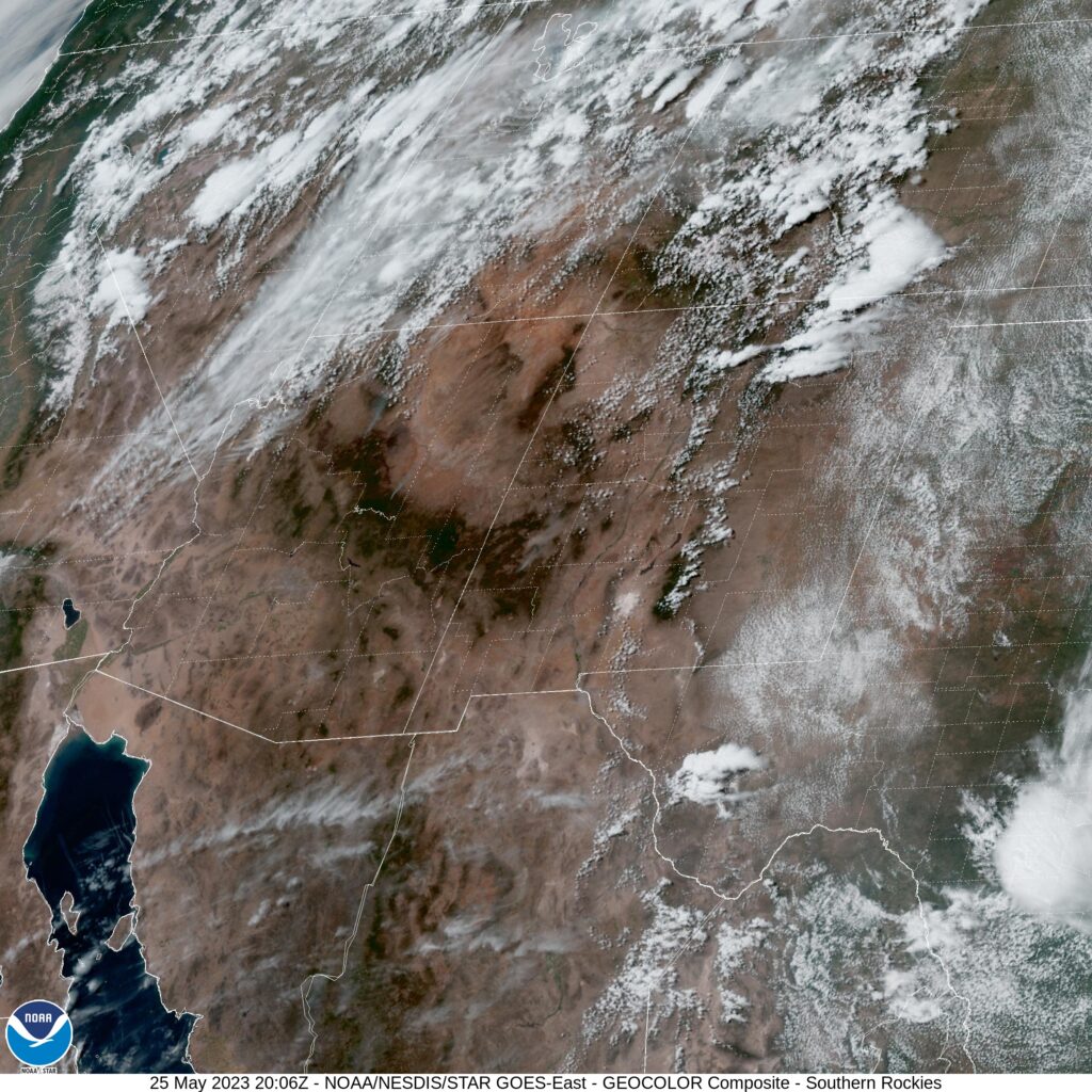
The low temperature guidance is completely divergent, and it appears as though many of our competitors are heeding the longer range, larger scope models. I’m wary, because it is the higher resolution models that are going warmer. I tend to trust them a little bit more when terrain is in play. And thus, I am on the higher end of those low forecasts. Here is the satellite centered over New Mexico, highlighting the flow up and around Arizona.
We are in late spring at this point, and have been undergoing a somewhat early season-ish spell, in which systems were charging through the southern US, leaving the northern US unaffected. As a local resident who was battered through the winter, I fairly appreciate that. It has made for a a chillier stretch through mid-May though, and that is what Iowa City was experiencing towards the beginning of last week. Without a feature moving through on Tuesday, temperatures soared into the 80s, however the next day, a system in the Tennessee Valley brought temperatures in Iowa City back down to the low 80s for a high. Forecasts were fine, though with mostly clear skies we would all like to have done better. The Weather Service and Accuweather drew level for this forecast. Actuals: Tuesday, High 81, Low 57 Wednesday – High 73, Low 52