It sure seemed like the cold air that trailed last weekend’s winter storm is a last gasp of the winter, given how warm it is going to be this week. Peoria even had the dignity to be colder than forecasts originally indicated by a handful of degrees. One outlet pegged the high temperature forecast on both days, thanks to a cooler numbers than most of the other outlets (except Weatherbug, of course). That top forecaster was The Weather Channel. Actuals: Saturday – High 45, Low 33 Sunday – High 49, Low 30
It’s a very quiet evening out there, weather fans. There is an area of low pressure driving into the Pacific Northwest, but when ISN’T there. This should be monitored, though, as we are going to be looking at some severe weather arising out of this wave on Thursday. Be patient, weather fans.
It should be noted that because of the clear skies and cold air filtering in behind the area of low pressure in the northeast, there are actually freeze warnings out in Alabama tonight
The conversation I keep hearing is people being reluctant to say we are at the end of winter, because in recent years, we have seen late March and April snows. It’s been a mild winter, and many Midwestern residents can’t accept that it might just be mild all the way through.
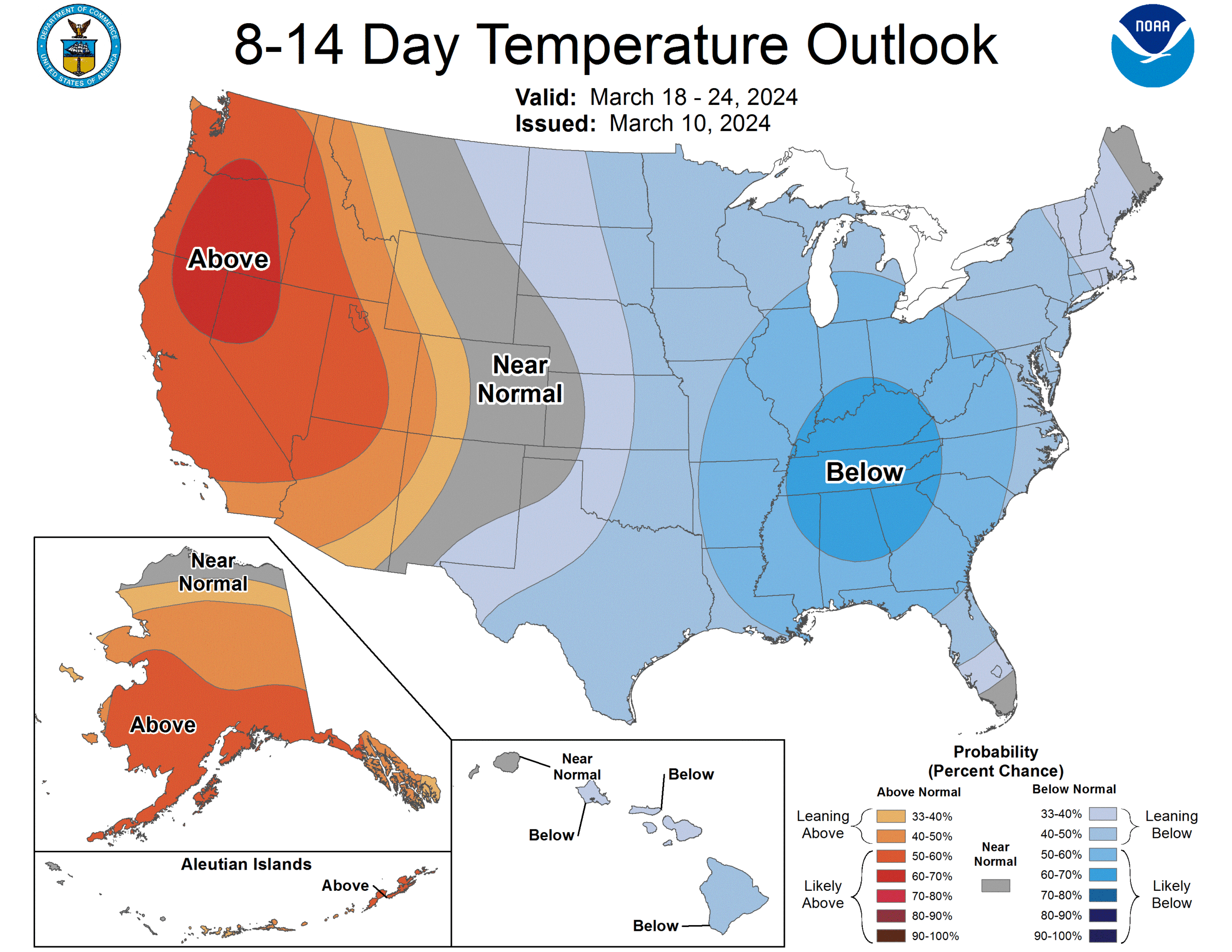
Well, through the middle of March, we have a trend for below normal temperatures, which could certainly make some people think it is a return of winter, but significant moisture isn’t going to come with that cool down, save, perhaps, for the Great Lakes.
A fairly inauspicious feature moving through the Great Lakes yesterday has tapped into some cold air as it arrives in the mid Atlantic. There is mixed precipitation east of the Great Lakes, and some snow falling in the terrain of the Poconos.
This part of the country, this time of year, you could really get anything out of a forecast. That is pretty exciting, and also could lead to some very peculiar forecasts.
At 1054PM, CT, Peoria was reporting a temperature of 43 degrees with overcast skies. A brisk northwest wind was filling the wake of some steady rain with clear and chilly air. After a soggy day in central Illinois, the last remaining bits of rain had moved nearly entirely into Indiana as a trough is swinging into the area at the upper levels, riding north of a strong jet propelling heavier storms in the southeastern US. At the surface, a pair of low pressure centers will gently orbit around each other, slowing their poleward advance. Behind this agglomeration, high pressure is going to emerge in the Plains, and drift eastward, bringing a dry weekend to Peoria. The ridge will also lay over the top of a thermal ridge, which means temperatures, though chilly tonight, will not remain so. Tomorrow – Mostly sunny, High 47, Low 33 Sunday – Sunny, High 53, Low 28
TWC: Tomorrow – Sunshine and clouds mixed High 45, Low 34 Sunday – A mainly sunny sky. High 49, Low 27
AW: Tomorrow – Variable cloudiness; breezy in the afternoon; clocks spring ahead 1 hour at night High 47, Low 36 Sunday – Plenty of sunshine High 51, Low 27
NWS: Tomorrow – A 20 percent chance of showers after 3pm. Cloudy, then gradually becoming mostly sunny High 45, Low 36 Sunday – Sunny, High 49, Low 27
WB: Tomorrow – Mostly cloudy in the morning then mostly sunny with a slight chance of showers in the afternoon, High 45, Low 39 Sunday – Sunny, High 46, Low 30
WN: Tomorrow – Partly cloudy with isolated showers, High 45, Low 36 Sunday – Sunny, High 48, Low 27
CLI:: Tomorrow – Clear, High 46, Low 34 Sunday – Sunny, High 50, Low 28
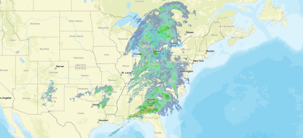
I am not sure about the chaser rain forecast that some outlets have tomorrow. I think it will be fine. I don’t often post such a broad radar, but it really gives the scope of the inclement conditions out there this evening, affecting a lot of people.
The flow through the jet fueled strong storms in the southeast to end the week, but there is very weak flow into this streak. What does that mean? Well, it means the West Coast can finally dry out and warm up. Welcome to the warm winter we’ve all been having, West Coast!
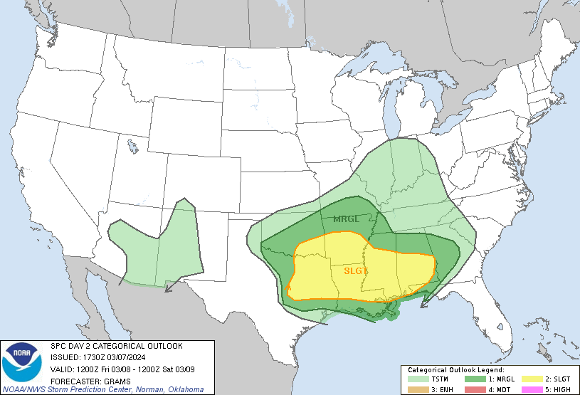
The early part of severe weather season gets it’s typical kickoff in what some people call the “Dixie Alley” which is focused primarily around Mississippi. We aren’t anticipating a massive outbreak on Saturday, but storms are indeed expected the next few days, starting today in west Texas and ending Saturday in Georgia and South Carolina. That leaves tomorrow for, you guessed it, Mississippi.
Low pressure is getting organized today in West Texas, giving rise to our first round of potential severe weather. Storms should be isolated, supercellular storms this afternoon and evening. Not everyone will see storms, but those that do will be threatened by tornadoes and large hail, centered around an area bound by Abilene, Fort Worth and Waco, but possible north into western Oklahoma as well.
The system will evolve overnight and after today’s activity, with the main, original area of low pressure rocketing towards the Great Lakes, and a surface low re-emerging in the ArkLaTex region. The entire system will be more sheared than it will be today, which will mean a lower likelihood of large standalone supercells, however a line of smaller such cells which ultimately form into a line of strong thunderstorms is the likely mode storms tomorrow evening. The greatest threat for severe weather will start around Shreveport before continuing through the night past Jackson and ultimately towards Montgomery.
By the time that Saturday rolls around. we are likely only to be tracking a line of strong thunderstorms. The tornado threat will be limited, but gusty straight line winds and hail are going to be pushing through the Peach, Palmetto and northern Sunshine state before dark on Saturday.
Two points to make about all of this. First, model guidance isn’t all on the same page for severe weather on any of these days. There could certainly be some big storms, including tornadic storms especially today, but tomorrow could ultimately be a low end severe weather day. There is only a slight risk for severe weather, accounting for the uncertainty.
Second, the individual storms will be strongest probably today, in Texas, and in the early afternoon over Louisiana and Arkansas, but will have the greatest coverage in Mississippi and eventually Alabama. After they redevelop tomorrow night, there likely is no turning these storms off until they are offshore.
As is always the case, stay tuned to your local weather authorities, and keep an eye on the weather. I described a narrow corridor, but storms are certainly possible for several miles on either side of this axis.
I noted in my forecast that I admired the outlets that were leaving rain out of the forecast in Huntsville for Monday. I thought what was showing up in the model guidance was just an overzealous interpretation of the increasing clouds in the area ahead of a cold front and vorticity maximum along the Gulf Coast. I also (this time correctly) suspected that this vort max would reduce overall rainfall in Huntsville, drawing it all into the center of circulation. I should have trusted myself on both accounts, because it didn’t rain a drop on Monday. Not that getting it correct would have helped. Clime ended up winning this one. Actuals: Monday – High 74, Low 54 Tuesday .07 inches of rain, High 64, Low 58