Oh, man, when we looked last week in Dallas, things were looking to get a little bit better. Now when I check in after the weekend expires, they are mired in some low ceilings and visibilities in the wake of a weak system that brought chilly rain to the region to start the week. At least they didn’t get the ice they got in Oklahoma City and Kansas City!
Charlotte, North Carolina
It’s a Carolina kind of day here at Victoria-Weather, after the earlier verification in South Carolina. What will we look forward to in the coming days in North Carolina?
At 952PM, ET, Charlotte was reporting a temperature of 42 degrees with overcast skies. Coastal North Carolina finds itself between a strong offshore low, and a wave sweeping in from the Great Lakes. The wave is ushering in cold air, while the strong low is inducing more rain and convective activity. The Great Lakes feature is dragging a cold front across the Appalachians right now, with rain and some sleet reported in the far western reaches at Andrews of the state. Not much, if any of this moisture will descend the mountains into Charlotte, but that doesn’t mean a dry 24 hours for the Queen City.
Light precipitation is going to linger in the area through most of the morning as the offshore low intensifies and adopts the clipper moving in from the northwest. While most of the moisture will be spent in the mountains, the cold air will not be. This will be a prime opportunity for cold air damming, but temperatures will still be chillier for the beginning of the weekend. Cold high pressure will trap the chilly temperatures
Tomorrow – A bit of drizzle, then clearing with temperatures dropping, High 48, Low 28
Saturday – Clear but quite cold, High 33, Low 18
TWC: Tomorrow – Partly cloudy skies with gusty winds developing during the afternoon. (early rain) High 48, Low 30
Saturday – Sunny. High 34, Low 20
AW: Tomorrow – Mostly cloudy; breezy in the afternoon (Early rain) High 49, Low 29
Saturday – Plenty of sunshine, but colder High 34, Low 22
NWS: Tomorrow – Mostly sunny, Early rain, High 47, Low 26
Saturday – Sunny High 33, Low 18
WB: Tomorrow – Partly sunny early, then clearing, (early rain) High 47, Low 28
Saturday – Sunny, High 33, Low 23
WN: Tomorrow – Partly cloudy (early rain), High 47, Low 25
Saturday – Sunny, High 33, Low 18
CLI: Tomorrow – Sunny (early rain) High 50, Low 27
Saturday – Sunny, High 36, Low 19
A pretty chilly day for Charlotte, shortly after a pretty chilly forecast for Dallas. I should note, that everyone had rain through about 5AM, but that doesn’t translate to their daily forecast. Here comes the rain on radar.
Post Frontal Florence
During last week’s version of the interminable series of storm systems this month, we visited Florence after a line of thunderstorms had brought severe weather to the city earlier in the day. There was a little bit of light rain that trailed the line that arrived a little bit after midnight that altered the verification a bit, but aside from that, post frontal forecasting is pretty easy. Victoria-Weather earned our first forecast W of the year, up against strong competition.
Actuals: Wednesday January 10th, .03 inches of rain High 52, Low 37
Thursday, January 11th, High 57, Low 33
Grade B-C
Dallas, Texas
The weather of Texas isn’t supposed to be like it’s been. Alas, it is January, and we have a robust, strong jet stream leading to an equally strong, robust surface pattern. Let’s continue to discuss.
At 253PM, CT, Dallas was reporting a temperature of 41 degrees with fair skies and a brisk south wind. High pressure has set up in the southeastern US, which is bringing about the southerly flow, however with the strong jet structure, another trough emerging is leading to a transient pattern, and todays blustery conditions.
The next upper level trough will have little reflection in terms of a well structured cyclone or precipitation, but the cold air mass will be defined and strong as it presses southward. It will remain dry and snow free in the MetroPlex, however even colder air will head south for the region on Thursday night.
Tomorrow – Mostly sunny, breezy, High 53, Low 32
Friday – Chilly in the morning, partly cloudy, High 37, Low 27
TWC: Tomorrow – Partly cloudy skies. High 57, Low 33
Friday – Sunny, High 36, Low 25
AW: Tomorrow – Warmer with plenty of sunshine High 55, Low 30
Friday – Breezy in the morning; otherwise, very cold with plenty of sunshine; after a brief break, very cold air returns High 36, Low 23
NWS: Tomorrow – Sunny, High 56, Low 32
Friday – Sunny, High 36, Low 24
WB: Tomorrow – Sunny, High 51, Low 31
Friday – Sunny, Much cooler, High 36, Low 28
WN: Tomorrow – Mostly sunny, High 56, Low 32
Friday – Sunny, High 36, Low 24
CLI: Tomorrow – Sunny, High 55, Low 33
Friday – Sunny, High 39, Low 23
Brr! That’s a cold Friday for most people, and especially in Texas. At least there isn’t the added challenge of driving in the snow or ice this time around. Clear skies overhead for the Lone Star State at this time.
The Wasatch, the Gulf of Alaska and the Great Basin
Sometimes, we all need a little bit of reality to bring us back to earth. After a strong forecast to start the year in New York, it didn’t go quite that well in Logan. The various topographies of the northwestern US and the proclivity for cyclonic development in the Gulf of Alaska made for a rough day of forecasting. The primary cause of the misguided forecast were the low temperatures that arose on Monday the 8th. Well, that and how warm it got on Tuesday. Oh, and for many, the snow that lasted into Monday morning when many thought there would be a longer break. I guess there were a few issues. On a more positive note, there was a tie at the top between The Weather Channel, Accuweather and the National Weather Service.
Actuals: Monday, January 8th -.03″ of precipitation in snow, High 25, Low 2
Tuesday – .04″ of precipitation in snow, High 36, Low 11
Grade: D
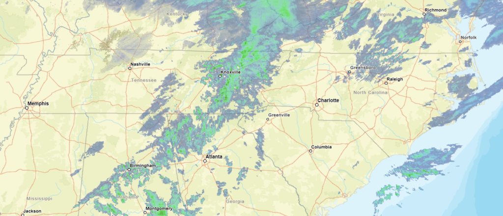
Lansing, Michigan
We’re off to Michigan’s capital to put together a forecast in the wake of yet another round of significant wintry weather. Are we in for a pause?
At 453PM, ET, Lansing was reporting a temperature of 5 degrees and a brisk northwest wind. The slow start to winter has led to a Lake Michigan much more capable of producing lake effect snow, and it is compounding the accumulations in the wake of yesterday’s event. All told, Lansing has received only a couple of inches, but over a foot has fallen along the lakeshore. A strong area of low pressure was retrograding to the west over Hudson Bay, sending brisk northwest winds to ensure that visibilities, even in the light snow, would be challenged.
Low pressure in Canada will continue to spin thanks to the support of a strong jet trough. At the surface over the center of the country, high pressure will build in. This will dry out most of the country, the part that relies on the Gulf of Mexico for it’s moisture, however the combination of features will only bring about gustier west winds in Michigan. Expect persistent west winds and some intermittent snow showers throughout the forecast period.
Tomorrow – Overcast with light snow, High 8, Low 0
Tuesday – Continued wind and clouds with light snow, High 9, Low 3
TWC: Tomorrow – Cloudy High 11, Low -4
Tuesday – Cloudy skies. Continued very cold. High 7, Low 4
AW: Tomorrow – Variable clouds with flurries, frigid; breezy in the morning; bitter cold; be sure to wear layers High 10, Low -1
Tuesday – Low clouds and bitterly cold; bitter cold; be sure to wear layers High 8, Low 6
NWS: Tomorrow – A 20 percent chance of snow showers after 1pm. Mostly cloudy and cold, High 10, Low -1
Tuesday – A 20 percent chance of snow showers after 1pm. Mostly cloudy and cold, High 9, Low 5
WB: Tomorrow – Partly sunny. Areas of blowing snow, High 9, Low 0
Tuesday – Partly sunny, High 9, Low 6
WN: Tomorrow – Mostly cloudy with slight chance of light snow showers, High 10, Low -1
Tuesday – Mostly cloudy with slight chance of light snow showers, High 9, Low 5
CLI: Tomorrow – Overcast, High 13, Low -3
Tuesday – Light snow showers, High 12, Low 3
Here is a look at the radar, which is going to look pretty familiar for lower Michigan radar watchers for the next couple of days.

Florence, South Carolina
We’re going to sneak down to the Carolinas on the heels of a very active weather day for the southeastern US.
At 906PM, ET, Florence was reporting a temperature of 54 degrees with scattered clouds. A line of thunderstorms swept through earlier, with 63kt gusts reported at Florence. Winds have died down, but with a few post frontal sprinkles over South Carolina, Florence stands to get a little bit more rain before all is said and done. The jet structure is still very active, which will only encourage the area of low pressure to drift to the northeast, bringing the threat for rain to an end overnight tonight.
The next round of low pressure is going to get organized in the south central US by Friday evening, which will also indicate the point at which warmer air will start returning to Florence. Dry conditions are expected in Florence from sunrise tomorrow through the day on Thursday.
Tomorrow – Some clouds early, then sunny, High 53, Low 38
Thursday – Mostly sunny, High 58, Low 34
TWC: Tomorrow – Sunny, along with a few afternoon clouds. High 53, Low 38
Thursday – Partly cloudy. High 59, Low 35
AW: Tomorrow – Partly sunny, windy and cooler High 53, Low 39
Thursday – Milder with plenty of sun High 61, Low 35
NWS: Tomorrow – Sunny, High 52, Low 40
Thursday – Mostly sunny, High 58, Low 34
WB: Tomorrow – Sunny, High 51, Low 41
Thursday – Mostly sunny, High 59, Low 35
WN: Tomorrow – Mostly sunny, High 52, Low 48
Thursday – Partly cloudy, High 57, Low 34
CLI: Tomorrow – Mostly cloudy, High 54, Low 39
Thursday – Mostly cloudy, High 61, Low 36
There was quite a bit of severe weather in the southern and southeastern US over the last 48 hours. The strongest and most intense storms were overnight in the Florida Panhandle, but now we are near a break.

Wintry mix, but light on the winter
New York is obviously the center of the universe, so it was nice that round one of our winter weather week was more problematic for points outside of the Big Apple. Close, but not in the city itself, especially during out forecast. There was a wintry mix in the afternoon on Saturday, but the winter portion of the mix only lasted for a couple of hours in Manhattan. Several inches, fell north of town, and more than a foot came to some of the mountains of Pennsylvania. It was a strong start to the year for the Weather Channel, who netted the forecast victory.
Actuals: Friday – High 41, Low 28
Saturday – Rain and snow, not measured, High 39, Low 32
Grade: A-C
Coming soon…
The weather to start 2024 has been pretty wild. Will it continue as we dig deeper into January?
Lansing, Michigan
Dallas, Texas
Charlotte, North Carolina
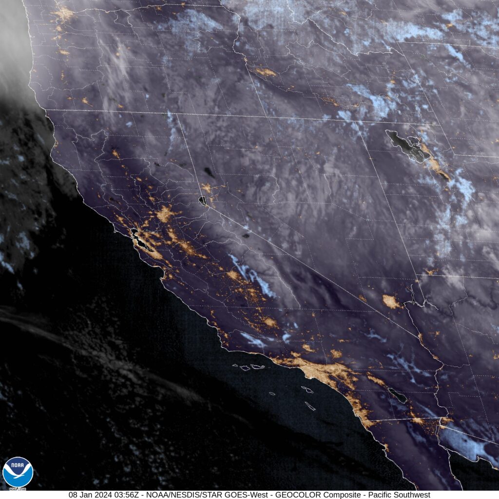
San Luis Obispo, California
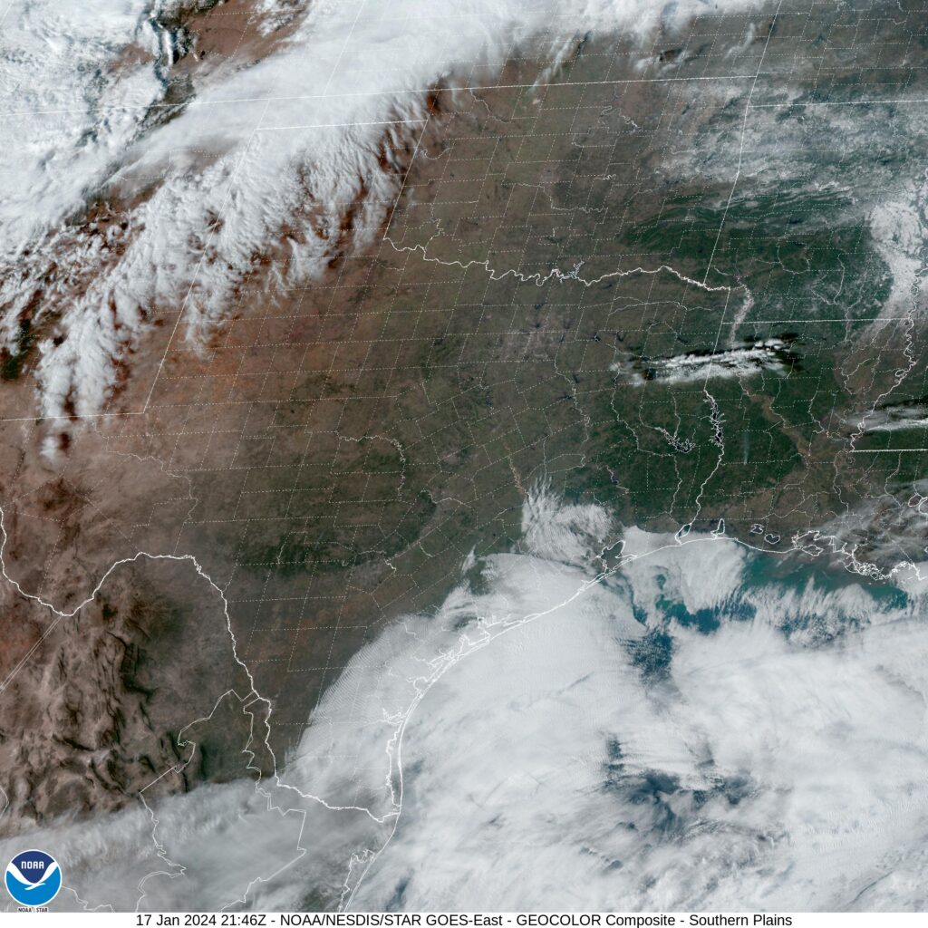
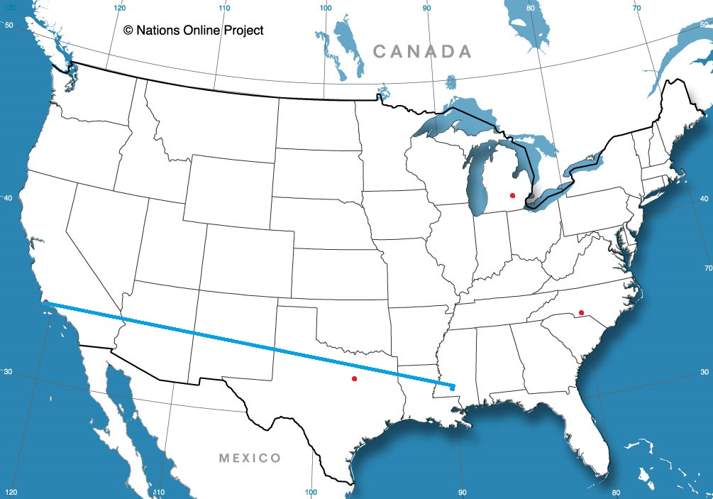
Road Trip from San Luis Obispo to Hattiesburg, Mississippi
Logan, Utah
We’re going to head to northern Utah, away from the real weather of the week, because that simply how we operate here at Victoria-Weather. Constantly missing the point.
At 851 PM, MT, Logan was reporting light snow and a temperature of 22 degrees. As the well advertised storm system begins to emerge in the southern High Plains, some of the same energy is bringing snow to the Wasatch Range. The sharp, strong trough that is the culprit behind the weather this week will transition out of the inter-mountain west by midday tomorrow, leaving the potential for some more flurries to continue into tomorrow morning in Logan.
The rest of the day and early Monday look as though they will continue to be tranquil thorough the early part of the day on Tuesday as well. The next upper level wave in the jet structure is rippling through the Gulf of Alaska, preparing to bring more wet weather to the Pacific Northwest. The storm system will press moisture beyond the Cascades and as far as northern Utah by Tuesday evening. It’s going to remain chilly in Logan, so precipitation is going to fall as snow, and will predominantly fall in higher terrain.
Tomorrow – A lingering flurry early, then increasingly sunny, High 25, Low 13
Tuesday – Sunny early, clouds and snow return late, High 27, Low 16
TWC: Tomorrow – Intervals of clouds and sunshine. High 25, Low 10
Tuesday – Cloudy with snow showers becoming a steady accumulating snow later on. High 30, Low 14
AW: Tomorrow – Mostly cloudy High 22, Low 9
Tuesday – Cloudy with a little snow High 30, Low 12
NWS: Tomorrow – Mostly sunny, High 24, Low 9
Tuesday – Snow, mainly after 11am. High 29, Low 11
WB: Tomorrow – Partly cloudy in the morning, then becoming sunny (Early snow) High 17, Low 13
Tuesday – Breezy. Snow likely in the morning then snow in the afternoon. High 23, Low 13
WN: Tomorrow – Partly cloudy, High 24, Low 13
Tuesday – Mostly cloudy with light snow, High 30, Low 11
CLI: Tomorrow – Mostly cloudy, High 24, Low 12
Tuesday – Blowing snow, High 32, Low 15
I’ll tell you what, these mountain forecasts sure get a lot of different forecasts. It doesn’t help that Utah doesn’t ever have an over head satellite image. You can see most of the snow is over the mountains.