Temperatures in the summer can be overwhelmingly warm in the Sunshine state, and in the winter, it gets a bit chillier than the natives can tolerate. In the spring, however, temperatures will b cool enough for anyone to sleep, and may not get to 80. That was what we saw in Palm Coast on the 5th and 6th of the month, Another nice thing about the time of year is that it is easier to leave rain out of the forecast because you can identify larger scale weather patterns. Comfortable temperatures and no rain? They should tell people about this place, they might want to vacation here. Victoria-Weather and The Weather Channel caught up to Weatherbug after a perfect day on the 5th, to end up with a three way victory. Actuals – April 5th, High 75, Low 46 April 6th, High 66, Low 51
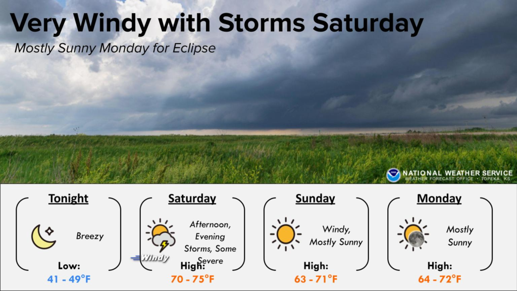
A lot of the attention for the week, including on this site, has revolved around the eclipse and whether or not we will be able to view it, even if we are in the axis of totality. The story for the rest of the week will follow a lot of the same territory, but will instead surround the threat for tornadoes and other severe weather.
A sharp upper level trough is moved into the Plains yesterday and isn’t really related to the inclement weather obscuring the sky during the eclipse. As it moved in, surface low pressure attempted to organize in west Texas that afternoon and evening. While access to moisture was be limited, access to potential energy was not.
In a scenario like this, you might see some “LP” or Low Precipitation supercells, which are the type that produce the photogenic tornadoes moving through open fields that you see in textbooks. The feature didn’t have enough tight circulation to introduce a bunch of tornadoes, but the updrafts were there, and even without much rain falling, we saw some jumbo sized hail.
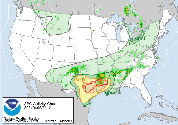
It will be more of the same today, but with the bullseye shifted to east Texas and western Louisiana. Additionally, the threat for tornadoes, though perhaps not gigantic twisters, will increase in this area as the low gets more focused and better moisture. We can see with the SPC activity loop that there are a couple of watches out already, and the threat for severe weather today is increasing
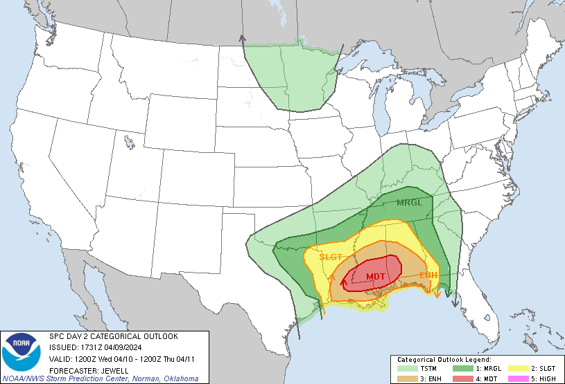
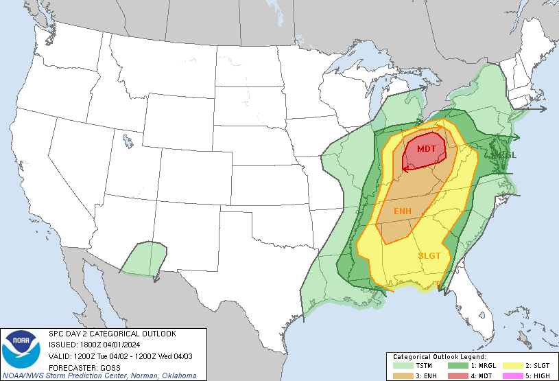
This negative trend will continue through the heart of Dixie Alley on Wednesday, with tornadoes and strong winds possible through Mississippi, and again on Thursday in Alabama, Georgia and north Florida. Especially by tomorrow, the ingredients will be perfectly meshed for a potentially high end severe weather event. There is a chance to see a major tornado outbreak in the moderate risk region for severe weather outlook, which include Baton Rouge, Jackson and the parts of Dixie Alley that are far too accustomed to this kind of weather.
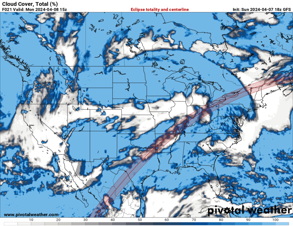
Cloud coverage forecast with the eclipse totality track overlaid, provided by pivotalweather.com
One thing that we know for sure about next week, is that for a long track of the eastern US, the moon will obfuscate the sun in the mid-afternoon. The eclipse is happening, and we’ve long known where the eclipse was happening.
Every forecast you see usually comes with a couple of words spared for the level of overcast on a given day. There is almost no brainpower expended on this process for most meteorologists that I know. Essentially, my go to method is to determine flow if you are near the sea, and proximity to an area of inclement weather. It works out well enough, and is frankly not something that many people follow up on.
So with that in mind, just know that I and most other weather people are flexing a muscle that we don’t often exercise when discussing the potential visibility of the celestial event of the year. I can state with some more knowledge that there will be an area of low pressure over the Upper Midwest that is quite occluded. At the time of the eclipse, the secondary low will be over the eastern Great Lakes, and the boundary will be along a line roughly from Pittsburgh to Houston.
Along that line, in particular, expect some clouds, and it will probably be a little dicey south of that boundary with moisture spilling into the region. The low over the Great Lakes, as well, will likely be more cloudy than not. Of course, this coincides with the axis of greatest coverage for the eclipse, which is a bummer for something so anticipated.
If you travel to Texas for the eclipse, you can still see some natural phenomenon in the evening. The next round of unstable weather will touch off some severe storms in west Texas, targeting the Wichita Falls area on Monday evening, with tornadoes a concern, along with large hail. I can confirm that these thunderstorms will completely obscure the sun.
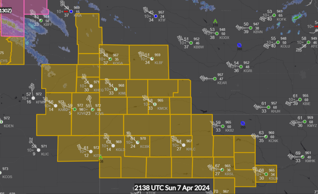
Low pressure moving through the Northern Plains today, in addition to bringing the threat for severe weather in the south and clouds to eclipse viewers for a lot of the country, is bringing some very gusty winds to some parched sections of the central US.
The Weather Service in Goodland called for hurricane force winds, and observations throughout the region are right there, with gusts over 50mph in many locales.
People area going to be looking close at Monday, and like Topeka, there are quite a few people that could see the eclipse that will be clouded over. More on that later this weekend.
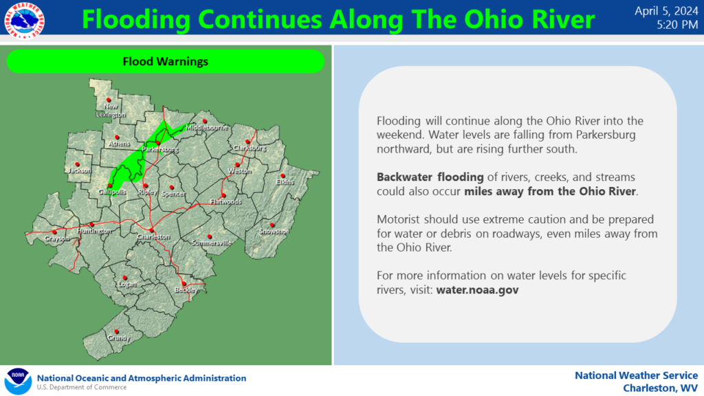
But with the intensity of some recent storms in the mid-Atlantic, there is a still a threat for some flash flooding, particularly in the coarser terrain of the Ohio Valley.
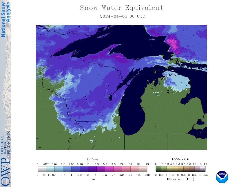
We spent part of our spring break at Wisconsin Dells and watched snow just keep piling up. The snow was laser focused on Wisconsin and Upper Michigan, which really was not the spring break mood we were hoping for. Ultimately, the real winner was Marquette, Michigan and the Keweenaw Peninsula, where even now, there is almost a foot of snow on the ground. Happy April!
Palm Coast is a fairly new addition to the census, having first been developed only starting in 1969, and incorporating 30 years later. Palm Coast is only 25, and in the last 25 years has grown by over 200%. It also has had a history of local wildfires. Will that be a factor with this forecast?
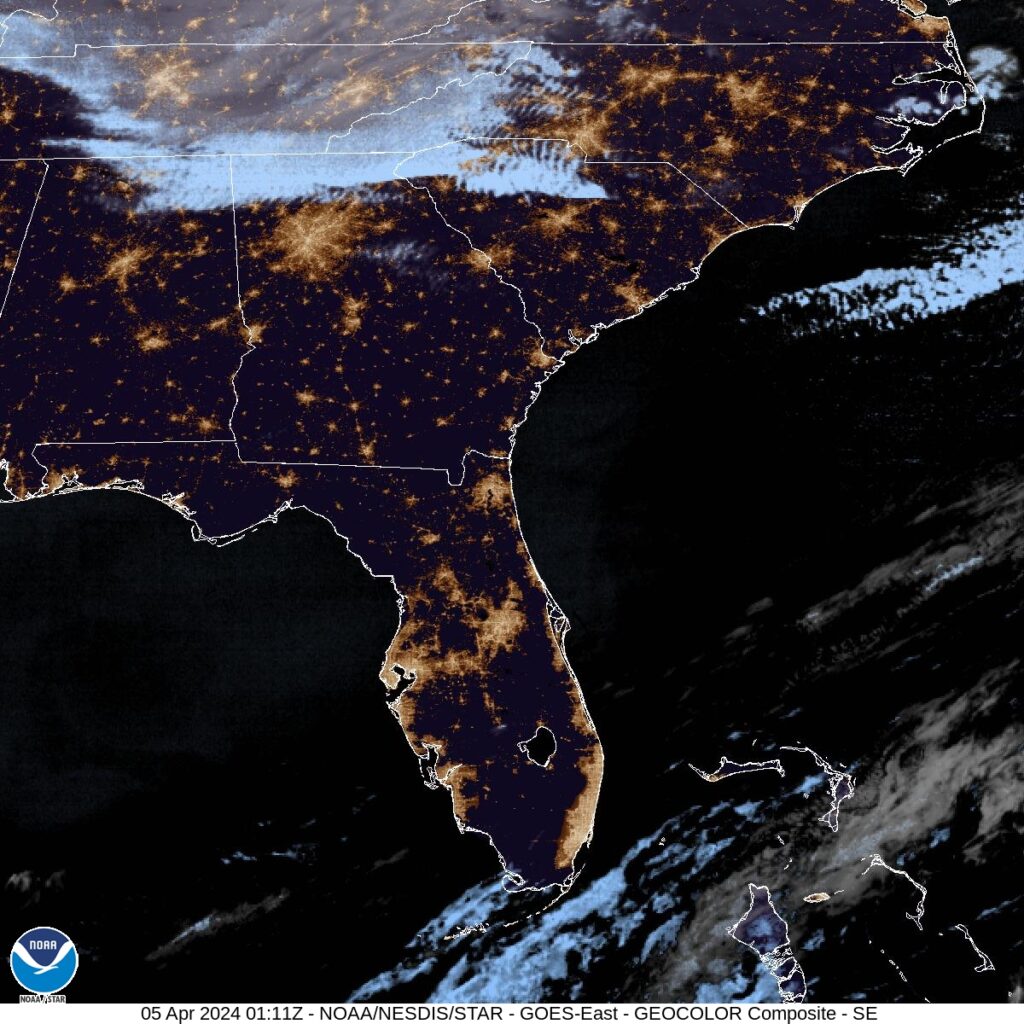
At 1035 PM, ET, Palm Coast was reporting a temperature of 58 degrees and clear skies. In fact, Florida found itself entirely under clear skies, which was surely helping with the temperatures dipping into the 50s in April. Low pressure was bringing a late season snow storm to interior New England, and its attendant cold front had already swept through the Sunshine State and was splitting the Bahamas this evening. The clear air will continue into the morning, before a ridge builds into the region. Expect a little bit of cloud cover to return in the afternoons of both Friday and Saturday, thanks to some light sea breezes. Flow aloft will be negligible over Florida, so surface features will have a greater role in the daily weather, but the region hasn’t hit the rainy season yet, and rain is not expected even if cumulus fields form. A weak upper level ridge in the southeast will provide another element of stability for the area. Tomorrow – Partly cloudy, High 75, Low 49 Saturday – Partly cloudy, High 69, Low 50
TWC: Tomorrow – A mainly sunny sky. High 75, Low 50 Saturday – Sunshine. High 69, Low 51
AW: Tomorrow – Nice with plenty of sun High 75, Low 51 Saturday – Partly sunny High 68, Low 52
NWS: Tomorrow -Sunny High 74, Low 50 Saturday – Sunny High 70, Low 50
WB: Tomorrow – Sunny, High 75, Low 46 Saturday – Sunny, High 68, Low 46
WN: Tomorrow – Sunny, High 72, Low 51 Saturday – Sunny, High 67, Low 51
CLI: Tomorrow – Sunny, High 73. Low 50 Saturday – Partly cloudy High 67, Low 50
A brisk north wind as the ridge settles in is going to be the driving factor in those temperatures coming down. Starting cool because of the crystal clear skies, however.
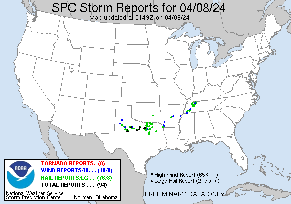
There have been quite a few severe storms this evening, from Indiana to Texas, including super cells with detected tornadoes and very large hail. St. Louis was in a tornado warning, and some suburbs saw 2″ diameter hail. There had been a moderate risk for severe weather over Oklahoma that has since been allowed to transition to an enhanced risk, but again, tomorrow, we are looking at a moderate risk, with the bullseye over a different “o” state – Ohio.
It’s absolutely severe season now, so this shouldn’t be a surprise. Be weather aware throughout the Buckeye State and even points south to the Florida Panhandle. Strong, long lived tornadoes are most likely, however, in that red shaded areas.
We’ve made it through the third month of the year that had an intense focus on the Midwest. Victoria-Weather, as should be expected, was strong for the month, but not as strong as The Weather Channel, who took the month, and the lead through three months for the year.

